Sacramento, California
| Sacramento, California | ||||||||
|---|---|---|---|---|---|---|---|---|
| State capital and charter city | ||||||||
| City of Sacramento | ||||||||
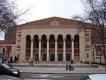
Clockwise from top left: California State Capitol, Sacramento RT Light Rail train through Midtown, Raley Field—View from West Sacramento, Downtown Sacramento skyline, Sacramento Memorial Auditorium, Sacramento Tower Bridge | ||||||||
| ||||||||
| Nickname(s): "City of Trees", "Sactown", "Sac", "Sacto" | ||||||||
|
Motto: Latin: Urbs Indomita (English: "Indomitable City") | ||||||||
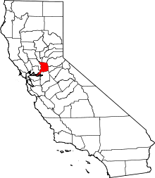
 Location of Sacramento in Sacramento County, California | ||||||||
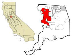
 Sacramento, California  Sacramento, California Location in the United States | ||||||||
| Coordinates: 38°33′20″N 121°28′08″W / 38.55556°N 121.46889°WCoordinates: 38°33′20″N 121°28′08″W / 38.55556°N 121.46889°W | ||||||||
| Country |
| |||||||
| State |
| |||||||
| County |
| |||||||
| Region | Sacramento Valley | |||||||
| CSA | Sacramento-Roseville | |||||||
| MSA | Sacramento–Roseville–Arden-Arcade | |||||||
| Incorporated | February 27, 1850[1] | |||||||
| Chartered | 1920[2] | |||||||
| Named for | Sacrament of the Holy Eucharist | |||||||
| Government | ||||||||
| • Type | City Council[3] | |||||||
| • Body | Sacramento City Council | |||||||
| • Mayor | Kevin Johnson[4] | |||||||
| • City Council[4] |
Councilmembers
| |||||||
| Area[5] | ||||||||
| • City | 100.105 sq mi (259.273 km2) | |||||||
| • Land | 97.915 sq mi (253.600 km2) | |||||||
| • Water | 2.190 sq mi (5.673 km2) 2.19% | |||||||
| Elevation[6] | 30 ft (9 m) | |||||||
| Population (April 1, 2010)[7] | ||||||||
| • City | 466,488 | |||||||
| • Estimate (2014)[7] | 485,199 | |||||||
| • Density | 4,700/sq mi (1,800/km2) | |||||||
| • Urban[8] | 1,723,634 | |||||||
| • Metro[9] | 2,149,127 | |||||||
| • CSA[10] | 2,414,783 | |||||||
| Demonym(s) | Sacramentan | |||||||
| Time zone | Pacific (UTC−8) | |||||||
| • Summer (DST) | PDT (UTC−7) | |||||||
| ZIP codes | 942xx, 958xx | |||||||
| Area code | 916 | |||||||
| FIPS code | 06-64000 | |||||||
| GNIS feature IDs | 1659564, 2411751 | |||||||
| Website |
cityofsacramento | |||||||


Sacramento (/ˌsækrəˈmɛntoʊ/; Spanish: [sakɾaˈmento]) is the capital city of the U.S. state of California and the seat of Sacramento County. It is at the confluence of the Sacramento River and the American River in the northern portion of California's expansive Central Valley. Its estimated 2014 population of 485,199 made it the sixth-largest city in California, and the 35th largest city in the United States.[7][11] Sacramento is the cultural and economic core of the Sacramento metropolitan area, which includes seven counties with a 2010 population of 2,414,783.[10] Its metropolitan area is the fourth largest in California after the Greater Los Angeles area, the San Francisco Bay Area, and the San Diego metropolitan area, and is the 27th largest in the United States. In 2002, the Civil Rights Project at Harvard University conducted for TIME magazine named Sacramento "America's Most Diverse City".[12]
Sacramento became a city through the efforts of the Swiss immigrant John Sutter, Sr., his son John Augustus Sutter, Jr., and James W. Marshall. Sacramento grew quickly thanks to the protection of Sutter's Fort, which was established by Sutter in 1839. During the California Gold Rush, Sacramento was a major distribution point, a commercial and agricultural center, and a terminus for wagon trains, stagecoaches, riverboats, the telegraph, the Pony Express, and the First Transcontinental Railroad.
The city was named after the Sacramento River, which forms its western border. The river was named by Spanish cavalry officer Gabriel Moraga for the Santísimo Sacramento (Blessed Sacrament), referring to the Catholic Eucharist.
California State University, Sacramento, more commonly known as Sacramento State or Sac State, is the largest university in the city and one of 23 campuses in the California State University system. University of the Pacific's Sacramento Campus is a private university with one of its three campuses in Sacramento. In addition, the University of California, Davis, is in nearby Davis, 15 miles (24 km) west of the capital. The UC Davis Medical Center, a world-renowned research hospital, is located in the city of Sacramento.
History
Indigenous culture
Nisenan (Southern Maidu) and Plains Miwok Native Americans had lived in the area for perhaps thousands of years. Unlike the settlers who would eventually make Sacramento their home, these Native Americans left little evidence of their existence. Traditionally, their diet was dominated by acorns taken from the plentiful oak trees in the region, and by fruits, bulbs, seeds, and roots gathered throughout the year.
Spanish exploration
In 1808, the Spanish explorer Gabriel Moraga discovered and named the Sacramento Valley and the Sacramento River. A Spanish writer with the Moraga expedition wrote: "Canopies of oaks and cottonwoods, many festooned with grapevines, overhung both sides of the blue current. Birds chattered in the trees and big fish darted through the pellucid depths. The air was like champagne, and (the Spaniards) drank deep of it, drank in the beauty around them. "Es como el sagrado sacramento! (It's like the Blessed Sacrament.)"[13] The valley and the river were then christened after the "Most Holy Sacrament of the Body and Blood of Christ", referring to the Catholic sacrament of the Eucharist.
Mexican Period: Sutter's Fort and New Helvetia
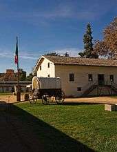
John Sutter first arrived on August 13, 1839 at the divergence of the American and Sacramento Rivers with a Mexican land grant of 50,000 acres. The next year, he and his party established Sutter's Fort, a massive adobe structure with walls eighteen feet high and three feet thick.[14]
Representing Mexico, Sutter called his colony New Helvetia, a Swiss inspired name, and was the political authority and dispenser of justice in the new settlement. Soon, the colony began to grow as more and more pioneers headed west. Within just a few short years, John Sutter had become a grand success, owning a ten-acre orchard and a herd of thirteen thousand cattle. Fort Sutter became a regular stop for the increasing number of immigrants coming through the valley. In 1847, Sutter hired James Marshall to build a sawmill so that he could continue to expand his empire.[14]
From pioneers to gold fever
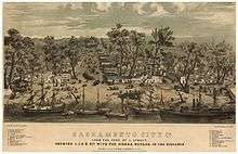
Sutter received 2,000 fruit trees in 1847, which started the agriculture industry in the Sacramento Valley. In 1848, when gold was discovered by James W. Marshall at Sutter's Mill in Coloma (located some 50 miles (80.5 km) northeast of the fort), a large number of gold-seekers came to the area, increasing the population. John Sutter, Jr. then planned the City of Sacramento 2 miles south of New Helvetia, in association with Sam Brannan against the wishes of his father, naming the city after the Sacramento River for commercial reasons. He hired topographical engineer William H. Warner to draft the official layout of the city, which included 26 lettered and 31 numbered streets (today's grid from C St. to Broadway and from Front St. to Alhambra Blvd.). However, a bitterness grew between the elder Sutter and his son as Sacramento became an overnight commercial success (Sutter's Fort, Mill and the town of Sutterville, all founded by John Sutter, Sr., would eventually fail).
The citizens of Sacramento adopted a city charter in 1849, which was recognized by the state legislature in 1850. Sacramento is the oldest incorporated city in California, incorporated on February 27, 1850.[15] During the early 1850s, the Sacramento valley was devastated by floods, fires and cholera epidemics. Despite this, because of its position just downstream from the Mother Lode in the Sierra Nevada, the new city grew, quickly reaching a population of 10,000.
Remnants of downtown Sacramento's Chinatown
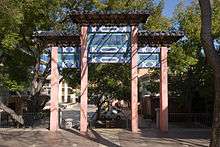
Throughout the early 1840s and 1850s, China was at war with Great Britain and France in the First and Second Opium Wars. The wars, along with endemic poverty in China, helped drive many Chinese immigrants to America. Many first came to San Francisco, which was then the largest city in California, which was known as "Dai Fow" (The Big City) and some came eventually to Sacramento (then the second-largest city in California), which is known as "Yee Fow" (Second City). Many of these immigrants came in hope of a better life as well as the possibility of finding gold in the foothills east of Sacramento.
Sacramento's Chinatown was located on "I" Street from Second to Sixth Streets. At the time, this area of "I" Street was considered a health hazard because - lying within a levee zone - it was lower than other parts of the city, which were situated on higher land. Throughout Sacramento's Chinatown history, there were fires, acts of discrimination, and prejudicial legislation such as the Chinese Exclusion Act that was not repealed until 1943. The mysterious fires were thought to be set off by those who did not take a liking to the Chinese working class.[16] Ordinances on what was viable building material were set into place to try to get the Chinese to move out. Newspapers such as The Sacramento Union wrote stories at the time that portrayed the Chinese in an unfavorable light to inspire ethnic discrimination and drive the Chinese away. As the years passed, a railroad was created over parts of the Chinatown, and further politics and laws would make it even harder for Chinese workers to sustain a living in Sacramento. While the east side of the country fought for higher wages and fewer working hours, many cities in the western United States wanted the Chinese out because of the belief that they were stealing jobs from the white working class.
The Chinese remained resilient despite these efforts. They built their buildings out of bricks just as the building guidelines were established. They helped build part of the railroads that span the city as well as made a great contribution to the transcontinental railroad that spans the United States. They also helped build the levees within Sacramento and its surrounding cities. As a result, the Chinese are a well-recognized part of Sacramento's history and heritage.
While most of Sacramento's Chinatown has now been razed, a small Chinatown mall remains as well as a museum dedicated to the history of Sacramento's Chinatown and the contributions Chinese Americans have made to the city. Amtrak sits along what was part of Sacramento's Chinatown "I" Street.[17][18]
Capital city
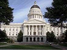
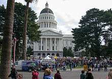
The California State Legislature, with the support of Governor John Bigler, moved to Sacramento in 1854. The capital of California under Spanish (and, subsequently, Mexican) rule had been Monterey, where in 1849 the first Constitutional Convention and state elections were held. The convention decided that San Jose would be the new state's capital. After 1850, when California's statehood was ratified, the legislature met in San Jose until 1851, Vallejo in 1852, and Benicia in 1853, before moving to Sacramento. In the 1879 Constitutional Convention, Sacramento was named to be the permanent state capital.
Begun in 1860 to be reminiscent of the United States Capitol in Washington, D.C., the Classical Revival style California State Capitol was completed in 1874. In 1861, the legislative session was moved to the Merchants Exchange Building in San Francisco for one session because of massive flooding in Sacramento. The legislative chambers were first occupied in 1869 while construction continued. From 1862 to 1868, part of the Leland Stanford Mansion was used for the governor's offices during Stanford's tenure as the Governor; and the legislature met in the Sacramento County Courthouse.

With its new status and strategic location, Sacramento quickly prospered and became the western end of the Pony Express. Later it became a terminus of the First Transcontinental Railroad, which began construction in Sacramento in 1863 and was financed by "The Big Four"—Mark Hopkins, Charles Crocker, Collis P. Huntington, and Leland Stanford.
In 1850 and again in 1861, Sacramento citizens were faced with a completely flooded town. After the devastating 1850 flood, Sacramento experienced a cholera epidemic and a flu epidemic, which crippled the town for several years. In 1861, Governor Leland Stanford, who was inaugurated in early January 1861, had to attend his inauguration in a rowboat, which was not too far from his house in town on N street. The flood waters were so bad, the legend says, that when he returned to his house, he had to enter into it through the second floor window. From 1862 until the mid-1870s Sacramento raised the level of its downtown by building reinforced brick walls on its downtown streets, and filling the resulting street walls with dirt. Thus the previous first floors of buildings became the basements, with open space between the street and the building, previously the sidewalk, now at the basement level. Most property owners used screw jacks to raise their buildings to the new grade. The sidewalks were covered, initially by wooden sidewalks, then brick barrel vaults, and eventually replaced by concrete sidewalks. Over the years, many of these underground spaces have been filled or destroyed by subsequent development. However, it is still possible to view portions of the "Sacramento Underground".
The same rivers that earlier brought death and destruction began to provide increasing levels of transportation and commerce. Both the American and especially Sacramento rivers would be key elements in the economic success of the city. In fact, Sacramento effectively controlled commerce on these rivers, and public works projects were funded though taxes levied on goods unloaded from boats and loaded onto rail cars in the historic Sacramento Rail Yards. Now both rivers are used extensively for recreation. The American River is a 5-mph (8-km/h) waterway for all power boats (including jet-ski and similar craft) (Source Sacramento County Parks & Recreation) and has become an international attraction for rafters and kayaking.
The Sacramento River sees many boaters, who can make day trips to nearby sloughs or continue along the Delta to the Bay Area and San Francisco. The Delta King, a paddlewheel steamboat which for eighteen months lay on the bottom of the San Francisco Bay, was refurbished and now boasts a hotel, a restaurant, and two different theaters for nightlife along the Old Sacramento riverfront.
Modern era
The city's current charter was adopted by voters in 1920.[19] As a charter city, Sacramento is exempt from many laws and regulations passed by the state legislature. The city has expanded continuously over the years. The 1964 merger of the City of North Sacramento with Sacramento substantially increased its population, and large annexations of the Natomas area eventually led to significant population growth throughout the 1970s, 1980s, and 1990s.
Sacramento County (along with a portion of adjacent Placer County) is served by a customer-owned electric utility, the Sacramento Municipal Utility District (SMUD). Sacramento voters approved the creation of SMUD in 1923.[20] In April 1946, after 12 years of litigation, a judge ordered Pacific Gas & Electric to transfer title of Sacramento's electric distribution system to SMUD. Today SMUD is the sixth-largest public electric utility in the U.S., and is a leader for innovative programs and services, including the development of clean fuel resources, such as solar power.[21] The year following the creation of SMUD, 1924, brought several events in Sacramento: Standard Oil executive Verne McGeorge established McGeorge School of Law, American department store Weinstock & Lubin opened a new store at 12th and K street, the US$2 million Senator Hotel was open, Sacramento's drinking water became filtered and treated drinking water, and Sacramento boxer Georgie Lee fought Francisco Guilledo, a Filipino professional boxer known as Pancho Villa, at L Street Auditorium on March 21.[22]
| Wikimedia Commons has media related to Japanese American internment processing in Sacramento. |
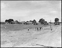
Early in World War II, the Sacramento Assembly Center (also known as the Walerga Assembly Center) was established to house Japanese Americans forcibly "evacuated" from the West Coast under Executive Order 9066. The camp was one of fifteen temporary detention facilities where over 110,000 Japanese Americans, two-thirds of them U.S. citizens, were held while construction on the more permanent War Relocation Authority camps was completed. The assembly center was built on the site of a former migrant labor camp, and inmates began arriving from Sacramento and San Joaquin Counties on May 6, 1942. It closed after only 52 days, on June 26, and the population of 4,739 was transferred to the Tule Lake concentration camp. The site was then turned over to the Army Signal Corps and dedicated as Camp Kohler. After the war and the end of the incarceration program, returning Japanese Americans were often unable to find housing and so 234 families temporarily lived at the former assembly center. Camp Kohler was destroyed by a fire in December 1947, and the assembly center site is now part of the Foothill Farms-North Highlands subdivision.[23]
The Sacramento-Yolo Port District was created in 1947, and ground was broken on the Port of Sacramento in 1949. On June 29, 1963, with 5,000 spectators waiting to welcome her, the Motor Vessel Taipei Victory arrived.[24] The port was open for business. The Nationalist Chinese flagship, freshly painted for the historic event, was loaded with 5,000 tons of bagged rice for Mitsui Trading Co. bound for Okinawa and 1,000 tons of logs for Japan. She was the first ocean-going vessel in Sacramento since the steamship Harpoon in 1934. The Port of Sacramento has been plagued with operating losses in recent years and faces bankruptcy. This severe loss in business is due to the heavy competition from the Port of Stockton, which has a larger facility and a deeper channel. As of 2006, the city of West Sacramento took responsibility for the Port of Sacramento. During the Vietnam War era, the Port of Sacramento was the major terminus in the supply route for all military parts, hardware and other cargo going into Southeast Asia.

In 1967, Ronald Reagan became the last Governor of California to live permanently in the city. A new executive mansion, constructed by private funds in a Sacramento suburb for Reagan, remained vacant for nearly forty years and was recently sold by the state.
The 1980s and 1990s saw the closure of several local military bases: McClellan Air Force Base, Mather Air Force Base, and Sacramento Army Depot. In 1980, there was another flood. The flood's damage affected the "boat section" of Interstate 5. The culmination of a series of storms as well as a faulty valve are believed to have caused this damage.
.JPG)
In the early 1990s, Mayor Joe Serna attempted to lure the Los Angeles Raiders football team to Sacramento, selling $50 million in bonds as earnest money. When the deal fell through, the bond proceeds were used to construct several large projects, including expanding the Sacramento Convention Center Complex and refurbishing of the Memorial Auditorium. Serna renamed a city park for migrant worker rights activist Cesar Chavez. Through his effort, Sacramento became the first major city in the country to have a paid municipal holiday honoring Chavez.
In spite of military base closures and the decline of agricultural food processing, Sacramento has continued to experience population growth in recent years. Primary sources of population growth are an influx of residents from the nearby San Francisco Bay Area, as well as immigration from Asia and Latin America. From 1990 to 2000, the city's population grew by 14.7%. The Census Bureau estimates that from 2000 to 2007, the county's population increased by nearly 164,000 residents.[25]
In the late 1990s and early 2000s (decade), Mayor Heather Fargo made several abortive attempts to provide taxpayer financing of a new sports arena for the Maloof brothers, owners of the Sacramento Kings NBA Basketball franchise. In November 2006, Sacramento voters soundly defeated a proposed sales tax hike to finance the plan. The defeat was due in part to competing plans for the new arena and its location.
In 2002, Time magazine featured an article recognizing Sacramento as the most diverse and integrated city in America.[26]
Despite a devolution of state bureaucracy, the state government remains by far Sacramento's largest employer. The City of Sacramento expends considerable effort to keep state agencies from moving outside the city limits.[27] In addition, many federal agencies have offices in Sacramento.
The California Supreme Court normally sits in nearby San Francisco.
Geography and climate
Geography


According to the United States Census Bureau, the city covers an area of 100.1 square miles (259 km2), 97.81% of it land, and 2.19% of it water.
Depth to groundwater is typically about 30 feet (9 m). Much of the land to the west of the city (in Yolo County) is permanently reserved for a vast flood control basin (the Yolo Bypass), due to the city's historical vulnerability to floods. As a result, the greater metropolitan area sprawls only four miles (6 km) west of downtown (as West Sacramento, California) but 30 miles (48 km) northeast and east, into the Sierra Nevada foothills, and 10 miles (16 km) to the south into valley farmland.
The city is located at the confluence of the Sacramento River and the American River, and has a deep-water port connected to the San Francisco Bay by a channel through the Sacramento–San Joaquin River Delta. It is the shipping and rail center for the Sacramento Valley. Food processing is among the major industries in the area.[28]
Cityscape
.jpg)
City neighborhoods
The city groups most of its neighborhoods into four areas:
Area one (central/eastern)
Alkali Flat, Boulevard Park, Campus Commons, Sacramento State, Dos Rios Triangle, Downtown, East Sacramento, Fab Forties, Mansion Flats, Marshall School, Midtown, New Era Park, Newton Booth, Old Sacramento, Poverty Ridge, Richards, Richmond Grove, River Park, Elmhurst, Sierra Oaks, Southside Park.[29]
Area two (southwestern)
Airport, Carleton Tract, Freeport Manor, Golf Course Terrace, Greenhaven, Curtis Park, Hollywood Park, Land Park, Little Pocket, Mangan Park, Meadowview, Parkway, Pocket, Sacramento City College, South Land Park, Valley Hi / North Laguna, Z'Berg Park.[30]
Area three (southeastern)
Alhambra Triangle, Avondale, Brentwood, Carleton Tract, Colonial Heights, Colonial Village, Colonial Village North, Curtis Park, Elmhurst, Fairgrounds, Florin, Industrial Park, Fruitridge Manor, Glen Elder, Glenbrook, Granite Regional Park, Lawrence Park, Med Center, North City Farms, Oak Park, Packard Bell, South City Farms, Southeast Village, Tahoe Park, Tahoe Park East, Tahoe Park South, Tallac Village, Vintage Park, Churchill Downs, and Woodbine.[31]
Area four (north of the American River)
Ben Ali, Del Paso Heights, Gardenland, Hagginwood, McClellan Heights West, Natomas (north, south, west), North Sacramento, Northgate, Robla, Swanston Estates, Terrace Manor, Valley View Acres, and Woodlake.[32]
Other areas
Additional prominent regions and neighborhoods in the city include American River Parkway, Arden, Arden Fair, Cal Expo, Capital Avenue, Coffing, College Glen, College Greens, Colonial Manor, Cordova, Creekside, East Fruitridge, Elder Creek, Elkhorn, Elvas, Erikson Industrial Park, Excelsior Sunrise, Foothill Farms, Franklin, Frates Ranch, Gateway Center, Gateway West, Glenwood Meadows, Hansen Park, Heritage Park, Johnson Business Park, Johnson Heights, Mayhew, Metro Center, Mills, Natomas Corporate Center, Natomas Creek, Natomas Crossing, Natomas Park, Newton Booth, Noralto, Northpointe, Norwood, Oak Knoll, Old North Sacramento, Parker Homes, Point West, Raley Industrial Park, Regency Park, Richardson Village, Richmond Grove, Rosemont, Sierra Oaks, Sports Complex, Strawberry Manor, Sundance Lake, Swanston Palms, Town and Country Village, Upper Land Park, Village 5, Village 7, Village 12, Village 14, Village Green, Walerga, Walsh Station, West Del Paso Heights, Westlake, Willowcreek, Wills Acres, Winn Park, Woodside and Youngs Heights.[33][34]
Climate
Sacramento has a Mediterranean climate (Köppen Csa), characterized by damp to wet, mild winters and hot, dry summers. The wet season is generally October through April, though there may be a day or two of light rainfall in June or September. The normal annual mean temperature is 61.0 °F (16.1 °C), with the monthly daily average temperature ranging from 46.4 °F (8.0 °C) in December to 75.5 °F (24.2 °C) in July.[35] Summer heat is often moderated by a sea breeze known as the "delta breeze" which comes through the Sacramento–San Joaquin River Delta from the San Francisco Bay, and temperatures cool down sharply at night.
The foggiest months are December and January. Tule fog can be extremely dense, lowering visibility to less than 100 feet (30 m) and making driving conditions extremely hazardous. Chilling tule fog events have been known to last for several consecutive days or weeks. During Tule fog events, temperatures do not exceed 50 degrees.
Snowfall is rare in Sacramento, which is only 25 ft (7.6 m) above sea level. In the downtown area, there have been only 3 significant snow accumulations since 1900, the last one being in 1976.[36] During especially cold winter and spring storms, intense showers do occasionally produce a significant amount of hail, which can create hazardous driving conditions. Snowfall that does fall in the city often melts upon ground contact, with traceable amounts occurring in some years. Significant annual snow accumulations occur in the foothills located 40 miles (64 km) east of the city, which had brief and traceable amounts of snowfall in January 2002, December 2009 and February 2011.[37][38]
On average, there are 73 days where the high exceeds 90 °F (32 °C), and 14 days where the high exceeds 100 °F (38 °C); On the other extreme, there are 15 days where the temperature does not exceed 50 °F (10 °C), and 15 freezing nights per year.[35] Official temperature extremes range from 18 °F (−8 °C) on December 22, 1990 to 115 °F (46 °C) on June 15, 1961;[35] a station around 5 mi (8.0 km) east-southeast of the city dipped to 17 °F (−8 °C) on December 11, 1932.[39]
The average annual precipitation is 18.52 inches (470 mm). On average, precipitation falls on 60 days each year in Sacramento, and nearly all of this falls during the winter months. Average January rainfall is 3.67 in (93 mm), and measurable precipitation is rare during the summer months. In February 1992, Sacramento had 16 consecutive days of rain, resulting in an accumulation of 6.41 in (163 mm) for the period. On rare occasions, monsoonal moisture surges from the Desert Southwest can bring upper-level moisture to the Sacramento region, leading to increased summer cloudiness, humidity, and even light showers and thunderstorms. Monsoon clouds do occur, usually during late July through early September. Sacramento is the second most flood susceptible city in the United States after New Orleans.[40]
Sacramento has been noted as being the sunniest location on the planet for three months of the year, from July through September. It holds the distinction as the sunniest month, in terms of percent possible sunshine, of anywhere in the world; July in Sacramento averages 14 hours and 12 minutes of sunshine per day, amounting to approximately 98% of possible sunshine.[41]
| Climate data for Sacramento, California (Sacramento Executive Airport), 1981–2010 normals,[lower-alpha 1] extremes 1941–present[lower-alpha 2] | |||||||||||||
|---|---|---|---|---|---|---|---|---|---|---|---|---|---|
| Month | Jan | Feb | Mar | Apr | May | Jun | Jul | Aug | Sep | Oct | Nov | Dec | Year |
| Record high °F (°C) | 76 (24) |
76 (24) |
88 (31) |
95 (35) |
105 (41) |
115 (46) |
114 (46) |
110 (43) |
108 (42) |
104 (40) |
87 (31) |
73 (23) |
115 (46) |
| Mean maximum °F (°C) | 64.0 (17.8) |
70.5 (21.4) |
76.8 (24.9) |
87.2 (30.7) |
95.8 (35.4) |
102.3 (39.1) |
105.0 (40.6) |
103.7 (39.8) |
100.1 (37.8) |
91.6 (33.1) |
76.1 (24.5) |
64.6 (18.1) |
106.8 (41.6) |
| Average high °F (°C) | 53.8 (12.1) |
60.3 (15.7) |
65.1 (18.4) |
71.1 (21.7) |
79.9 (26.6) |
87.1 (30.6) |
92.1 (33.4) |
91.2 (32.9) |
87.2 (30.7) |
77.6 (25.3) |
63.8 (17.7) |
53.9 (12.2) |
73.6 (23.1) |
| Average low °F (°C) | 38.8 (3.8) |
41.4 (5.2) |
44.1 (6.7) |
46.2 (7.9) |
51.1 (10.6) |
55.8 (13.2) |
58.4 (14.7) |
58.0 (14.4) |
55.7 (13.2) |
50.2 (10.1) |
42.8 (6) |
38.4 (3.6) |
48.4 (9.1) |
| Mean minimum °F (°C) | 29.1 (−1.6) |
31.5 (−0.3) |
35.1 (1.7) |
38.0 (3.3) |
42.9 (6.1) |
48.7 (9.3) |
53.1 (11.7) |
53.0 (11.7) |
49.2 (9.6) |
41.7 (5.4) |
32.5 (0.3) |
28.5 (−1.9) |
26.6 (−3) |
| Record low °F (°C) | 20 (−7) |
23 (−5) |
26 (−3) |
31 (−1) |
34 (1) |
41 (5) |
48 (9) |
48 (9) |
42 (6) |
35 (2) |
26 (−3) |
18 (−8) |
18 (−8) |
| Average precipitation inches (mm) | 3.64 (92.5) |
3.47 (88.1) |
2.75 (69.9) |
1.15 (29.2) |
0.68 (17.3) |
0.21 (5.3) |
0 (0) |
0.05 (1.3) |
0.29 (7.4) |
0.95 (24.1) |
2.08 (52.8) |
3.25 (82.6) |
18.25 (463.6) |
| Average precipitation days (≥ 0.01 in) | 10.3 | 9.4 | 9.1 | 4.9 | 3.2 | 1.2 | 0 | 0.3 | 1.3 | 3.6 | 6.9 | 9.9 | 60.0 |
| Average relative humidity (%) | 83.3 | 76.8 | 71.6 | 64.5 | 58.9 | 55.0 | 53.2 | 55.7 | 57.0 | 63.1 | 75.6 | 82.9 | 66.5 |
| Mean monthly sunshine hours | 145.5 | 201.3 | 278.0 | 329.6 | 406.3 | 419.5 | 440.2 | 406.9 | 347.8 | 296.7 | 194.9 | 141.1 | 3,607.8 |
| Percent possible sunshine | 48 | 67 | 75 | 83 | 92 | 94 | 98 | 96 | 93 | 86 | 64 | 48 | 81 |
| Source: NOAA (relative humidity and sun 1961–1990)[43][44] | |||||||||||||
| Climate data for Sacramento 5 ESE, California (1981–2010 normals,[lower-alpha 1] extremes 1877–present) | |||||||||||||
|---|---|---|---|---|---|---|---|---|---|---|---|---|---|
| Month | Jan | Feb | Mar | Apr | May | Jun | Jul | Aug | Sep | Oct | Nov | Dec | Year |
| Record high °F (°C) | 79 (26) |
80 (27) |
90 (32) |
98 (37) |
107 (42) |
112 (44) |
114 (46) |
111 (44) |
109 (43) |
102 (39) |
86 (30) |
72 (22) |
114 (46) |
| Mean maximum °F (°C) | 65.7 (18.7) |
72.8 (22.7) |
80.0 (26.7) |
90.2 (32.3) |
97.9 (36.6) |
104.1 (40.1) |
106.6 (41.4) |
105.4 (40.8) |
101.7 (38.7) |
93.1 (33.9) |
77.0 (25) |
65.6 (18.7) |
108.3 (42.4) |
| Average high °F (°C) | 54.4 (12.4) |
61.2 (16.2) |
66.8 (19.3) |
72.7 (22.6) |
80.9 (27.2) |
87.9 (31.1) |
93.3 (34.1) |
92.2 (33.4) |
87.9 (31.1) |
77.9 (25.5) |
63.7 (17.6) |
54.3 (12.4) |
74.4 (23.6) |
| Average low °F (°C) | 40.7 (4.8) |
43.7 (6.5) |
46.5 (8.1) |
49.0 (9.4) |
53.9 (12.2) |
58.4 (14.7) |
60.9 (16.1) |
60.5 (15.8) |
58.4 (14.7) |
52.8 (11.6) |
45.5 (7.5) |
40.4 (4.7) |
50.9 (10.5) |
| Mean minimum °F (°C) | 32.8 (0.4) |
35.0 (1.7) |
38.7 (3.7) |
41.9 (5.5) |
46.7 (8.2) |
51.6 (10.9) |
55.0 (12.8) |
55.3 (12.9) |
52.1 (11.2) |
45.1 (7.3) |
35.7 (2.1) |
31.5 (−0.3) |
30.1 (−1.1) |
| Record low °F (°C) | 19 (−7) |
21 (−6) |
29 (−2) |
34 (1) |
37 (3) |
43 (6) |
47 (8) |
48 (9) |
44 (7) |
34 (1) |
27 (−3) |
17 (−8) |
17 (−8) |
| Average precipitation inches (mm) | 3.97 (100.8) |
3.69 (93.7) |
3.02 (76.7) |
1.30 (33) |
0.76 (19.3) |
0.19 (4.8) |
0 (0) |
0.03 (0.8) |
0.35 (8.9) |
1.05 (26.7) |
2.43 (61.7) |
3.48 (88.4) |
20.27 (514.9) |
| Average precipitation days (≥ 0.01 in) | 11.2 | 9.8 | 9.2 | 5.2 | 3.2 | 1.2 | 0.1 | 0.4 | 1.4 | 3.6 | 7.4 | 10.5 | 63.5 |
| Source: NOAA[43], Western Regional Climate Center[45] | |||||||||||||
Demographics
| Historical population | |||
|---|---|---|---|
| Census | Pop. | %± | |
| 1850 | 6,820 | — | |
| 1860 | 13,785 | 102.1% | |
| 1870 | 16,283 | 18.1% | |
| 1880 | 21,420 | 31.5% | |
| 1890 | 26,386 | 23.2% | |
| 1900 | 29,282 | 11.0% | |
| 1910 | 44,696 | 52.6% | |
| 1920 | 65,908 | 47.5% | |
| 1930 | 93,750 | 42.2% | |
| 1940 | 105,958 | 13.0% | |
| 1950 | 137,572 | 29.8% | |
| 1960 | 191,667 | 39.3% | |
| 1970 | 257,105 | 34.1% | |
| 1980 | 275,741 | 7.2% | |
| 1990 | 369,365 | 34.0% | |
| 2000 | 407,018 | 10.2% | |
| 2010 | 466,488 | 14.6% | |
| Est. 2015 | 490,712 | [46] | 5.2% |
| Racial composition | 2010[48] | 1990[49] | 1970[49] | 1940[49] |
|---|---|---|---|---|
| White | 45.0% | 60.1% | 81.5% | 94.2% |
| —Non-Hispanic | 34.5% | 53.4% | 71.4%[50] | n/a |
| African American | 14.6% | 15.3% | 10.7% | 1.4% |
| Hispanic or Latino (of any race) | 26.9% | 16.2% | 11.0%[50] | n/a |
| Asian | 18.3% | 15.0% | 6.5% | 4.3% |
2010
The 2010 United States Census[51] reported that Sacramento had a population of 466,488. The population density was 4,660.0 people per square mile (1,799.2/km²).
The racial makeup of Sacramento was :
- 210,006 (45.0%) White
- 68,335 (14.6%) African American
- 85,503 (17.8%) Asian (4.2% Chinese, 3.3% Hmong, 2.8% Filipino, 1.6% Indian, 1.4% Vietnamese, 1.2% Laotian, 1.2% Japanese, 0.3% Pakistani, 0.3% Korean, 0.3% Thai, 0.2% Cambodian)
- 6,655 (1.4%) Pacific Islander (0.6% Fijian, 0.2% Tongan, 0.2% Samoan)
- 5,291 (1.1%) Native American
- 57,573 (12.3%) other races
- 33,125 (7.1%) from two or more races.
Hispanic or Latino of any race were 125,276 persons (26.9%); 22.6% of Sacramento's population is of Mexican heritage, 0.7% Puerto Rican, 0.5% Salvadoran, 0.2% Guatemalan, and 0.2% Nicaraguan.[52] Non-Hispanic Whites were 34.5% of the population in 2010,[48] down from 71.4% in 1970.[49]
The Census reported that 458,174 people (98.2% of the population) lived in households, 4,268 (0.9%) lived in non-institutionalized group quarters, and 4,046 (0.9%) were institutionalized. Also, with the recent housing crash there have been no changes to these numbers.
There were 174,624 households, out of which 57,870 (33.1%) had children under the age of 18 living in them, 65,556 (37.5%) were opposite-sex married couples living together, 27,640 (15.8%) had a female householder with no husband present, 10,534 (6.0%) had a male householder with no wife present. There were 13,234 (7.6%) unmarried opposite-sex partnerships, and 2,498 (1.4%) same-sex married couples or partnerships. 53,342 households (30.5%) were made up of individuals and 14,926 (8.5%) had someone living alone who was 65 years of age or older. The average household size was 2.62. There were 103,730 families (59.4% of all households); the average family size was 3.37.
Sacramento has one of the highest LGBT populations per capita, ranking seventh among major American cities, and third in California behind San Francisco and slightly behind Oakland, with roughly 10% of the city's total population identifying themselves as gay, lesbian, or bisexual.[53]
The age distribution of the city was follows: 116,121 people (24.9%) were under the age of 18, 52,438 people (11.2%) aged 18 to 24, 139,093 people (29.8%) aged 25 to 44, 109,416 people (23.5%) aged 45 to 64, and 49,420 people (10.6%) who were 65 years of age or older. The median age was 33.0 years. For every 100 females there were 94.9 males. For every 100 females age 18 and over, there were 92.2 males.
There were 190,911 housing units at an average density of 1,907.1 per square mile (736.3/km²), of which 86,271 (49.4%) were owner-occupied, and 88,353 (50.6%) were occupied by renters. The homeowner vacancy rate was 2.8%; the rental vacancy rate was 8.3%. 231,593 people (49.6% of the population) lived in owner-occupied housing units and 226,581 people (48.6%) lived in rental housing units.
2000
As of the census[54] of 2000, there are 407,018 people, 154,581 households, and 91,202 families residing in the city. The population density is 4,189.2 people per square mile (1,617.4/km²). There are 163,957 housing units at an average density of 1,687.5 per square mile (651.5/km²). The racial makeup of the city is 41.1% White, 19.5% African American, 1.3% Native American, 12.6% Asian, 0.9% Native Hawaiian and Pacific Islander, 11.0% from other races, and 6.4% from two or more races. 21.6% of the population are Hispanic or Latino of any race.
There are 154,581 households out of which 30.2% have children under the age of 18 living with them, 38.4% are married couples living together, 15.4% have a female householder with no husband present, and 41.0% are non-families. 32.0% of all households are made up of individuals and 9.2% have someone living alone who is 65 years of age or older. The average household size is 2.57 and the average family size is 3.35.

In the city, the age distribution of the population shows 27.3% under the age of 18, 10.4% from 18 to 24, 30.7% from 25 to 44, 20.2% from 45 to 64, and 11.4% who are 65 years of age or older. The median age is 33 years. For every 100 females there are 94.5 males. For every 100 females age 18 and over, there are 91.0 males.
The median income for a household in the city is $37,049, and the median income for a family is $42,051. Males have a median income of $35,946 versus $31,318 for females. The per capita income for the city is $18,721. 20.0% of the population and 15.3% of families are below the poverty line. Out of the total population, 29.5% of those under the age of 18 and 9.0% of those 65 and older are living below the poverty line.
Factors such as mild climate, a location at the crossroads of major interstate highways and railroads, and the availability of campsites along the rivers, as well as an outlook of tolerance, allow homeless people to survive.
Sacramento is notably diverse racially, ethnically, and by household income, and has a notable lack of interracial disharmony. In 2002, the Civil Rights Project at Harvard University conducted for TIME magazine named Sacramento "America's Most Diverse City".[12] The U.S. Census Bureau also groups Sacramento with other U.S. cities having a "high diversity" rating of the diversity index.[55]
Economy
Sutter Health, Blue Diamond Growers, Aerojet, Teichert, and The McClatchy Company are among the companies based in Sacramento.
Top employers
As of 2012,[56] the top employers in the City of Sacramento were:
| # | Employer | Employees |
|---|---|---|
| 1 | State of California | 69,763 |
| 2 | Sacramento County | 11,450 |
| 3 | UC Davis Health System | 7,725 |
| 4 | Dignity Health/Catholic Healthcare West | 7,069 |
| 5 | Intel | 6,633 |
| 6 | Kaiser Permanente | 6,360 |
| 7 | Sutter Health | 5,765 |
| 8 | Elk Grove Unified School District | 5,021 |
| 9 | Sacramento City Unified School District | 5,000 |
| 10 | San Juan Unified School District | 4,700 |
| 11 | City of Sacramento | 4,083 |
Culture and arts

Old Sacramento
The oldest part of the town besides Sutter's Fort is Old Sacramento, which consists of cobbled streets and many historic buildings, several from the 1850s and 1860s. Buildings have been preserved, restored or reconstructed, and the district is now a substantial tourist attraction, with rides on steam-hauled historic trains and paddle steamers.
The historic buildings include the Lady Adams Building, built by the passengers and ship's carpenters of the ship Lady Adams.[57] Having survived the Great Conflagration of November 1852, it is the oldest surviving building in Sacramento other than Sutter's Fort.[57]
Another surviving landmark is the B.F. Hastings building, built in 1853. Early home of the California Supreme Court and the location of the office of Theodore Judah, it also was the western terminus of the Pony Express.[58]
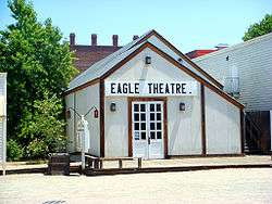
The "Big Four Building", built in 1852, was home to the offices of Collis Huntington, Mark Hopkins, Leland Stanford, and Charles Crocker. The Central Pacific Railroad and Southern Pacific Railroad were founded there. The original building was destroyed in 1963 for the construction of Interstate 5, but was re-created using original elements in 1965. It is now a National Historic Landmark. Also of historic interest is the Eagle Theatre (Sacramento, California), a reconstruction of California's first permanent theatre in its original location.
Theater arts
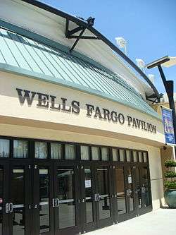
There are several major theatre venues for Sacramento. The Sacramento Convention Center Complex governs both the Community Center Theatre and Memorial Auditorium. The Wells Fargo Pavilion is the most recent addition in 2003. It is built atop the old Music Circus tent foundations. Next to that is the McClatchy Main stage, originally built as a television studio, which was renovated at the same time the pavilion was built. It is the smaller of the venues and provides seating for only 300. The Sacramento Ballet, Sacramento Philharmonic Orchestra and the Sacramento Opera perform at the Community Center Theater.
Professional theatre is represented in Sacramento by a number of companies. California Musical Theatre and its Summer stock theatre, Music Circus, lure many directors, performers, and artists from New York and Los Angeles to work alongside a large local staff for their productions at the Wells Fargo Pavilion.
During the fall, winter and spring seasons Broadway Sacramento brings bus and truck tours to the Community Center Theater. At the B Street Theatre, smaller and more intimate professional productions are performed as well as a children's theatre that will soon be opening a larger theatre complex in the heart of midtown in 2014. Rounding out the professional companies is Capital Stage, which performed aboard the Delta King until the end of the 2010–2011 season and soon took up residence at its own venue along the J-Street corridor.
The Sacramento area has one of the largest collection of community theatres in California. Some of these include the Thistle Dew Dessert Theatre and Playwrights Workshop, Davis Musical Theatre Co., El Dorado Musical Theatre, Runaway Stage Productions, River City Theatre Company, Flying Monkey Productions, The Actor's Theatre, KOLT Run Productions, Kookaburra Productions, Big Idea Theatre, Celebration Arts, Lambda Player, Light Opera Theatre of Sacramento, Synergy Stage and the historic Eagle Theatre. The Sacramento Shakespeare Festival provides entertainment under the stars every summer in William Land Park. Many of these theatres compete annually for the Elly Awards overseen by The Sacramento Area Regional Theatre Alliance or SARTA.
Visual arts
The Sacramento Metropolitan Arts Commission is an organization which was established as the Sacramento arts council in 1977 to provide several arts programs for the city. These include Art in Public Places, Arts Education, Grants and Cultural Programs, Poet Laureate Program, Arts Stabilization Programs and Other Resources and opportunities.
Sacramento Second Saturday Art Walk is a program of local art galleries that stay open into the late evenings every second Saturday of each month, providing a unique experience for the local population as well as tourists to view original art and meet the artists themselves.
Museums
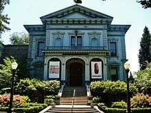
Sacramento has several major museums. The Crocker Art Museum is the oldest public art museum west of the Mississippi River. On July 26, 2007, the museum broke ground for an expansion that more than tripled the museum's floor space. The modern architecture is very different from the museum's original Victorian style building. Construction was completed in 2010.

Also of interest is the Governor's Mansion State Historic Park, a large Victorian Mansion which was home to 13 of California's Governors. The Leland Stanford Mansion State Historic Park, which was completely restored in 2006, serves as the State's official address for diplomatic and business receptions. Guided public tours are available. The California Museum for History, Women, and the Arts, home of the California Hall of Fame, is a cultural destination dedicated to telling the rich history of California and its unique influence on the world of ideas, innovation, art and culture. The museum educates tens of thousands of school children through inspiring programs, sharing with world visitors California's rich art, history and cultural legacy through dynamic exhibits, and serving as a public forum and international meeting place. The California State Railroad Museum in Old Sacramento has historical exhibits and live steam locomotives that patrons may ride. The California Automobile Museum, located just south of Old Sacramento, is filled with automotive history and vehicles from 1880 to 2006 and is the oldest non-profit automotive museum in the West. The mission of it is to preserve, promote, and teach automotive culture and its influence on our lives—past, present and future. In addition, the Sacramento History Museum, in the heart of Old Sacramento, focuses on the history of Sacramento from the region's pre-Gold Rush history through the present day.
There is a Museum Day held in Sacramento every year, when 26 museums in the greater Sacramento area offer free admission. The 2009 Sacramento Museum Day brought out more than 80,000 people, the largest number the event has gathered. Sacramento Museum Day is held every year on the first Saturday of February.
Music
Tower Records was started and based in Sacramento until its closing.[59] Rappers C-Bo, Marvaless, and Lunasicc are among those native to the area. Classical music is widely available. The Sacramento Philharmonic Orchestra, the Sacramento Baroque Soloists, the Sacramento Choral Society & Orchestra, the Sacramento Youth Symphony, the Sacramento Master Singers, the Sacramento Children's Chorus, and the Camellia Symphony each present a full season of concerts.
Each year, the city hosts the Sammies, the Sacramento Music Awards. Sacramento also has a reputation as a center for Dixieland jazz, because of the Sacramento Jazz Jubilee which is held every Memorial Day weekend. Events and performances are held in multiple locations throughout the city. Each year thousands of jazz fans from all over the world visit for this one weekend.
A growing number of rock, hardcore and metal bands hail from the Sacramento area, including Tesla, Deftones, Papa Roach, Will Haven, Trash Talk,[60][61][62] Dance Gavin Dance, A Lot Like Birds, Far, CAKE, !!!, Oleander and Steel Breeze; plus some other famous musicians like record producer and recording artist Charlie Peacock, Bob Stubbs of Social Distortion and Craig Chaquico of Jefferson Starship.
Scottish pop band Middle of the Road sung kindly of Sacramento in their 1972 European hit song "Sacramento". Experimental groups such as Hella, Death Grips, and Tera Melos also come out of Sacramento.
Film
Sacramento is home to the Sacramento French Film Festival, a cultural event held every year in July that features U.S. premieres of French films and classic masterpieces of French cinema and the Sacramento Japanese Film Festival,[63] also held in July. In addition, Sacramento is home to the Trash Film Orgy, a summer film festival celebrating the absurd, B-movies, horror, monster, exploitation.[64] Founded in 2007, the Sacramento Horror Film Festival showcases feature-length and short films as well as live musical and theatrical performances in the horror and macabre genres.[65]
Of note, Sacramento has been home to various actors, including Eddie Murphy, who resided in the Riverlake community of Pocket-Greenhaven with his then wife Nicole Mitchell Murphy, a fashion model and Sacramento native.
Food
In 2012, Sacramento started the marketing campaign as "America's Farm-to-Fork Capital" due to Sacramento's many restaurants that source their food locally from the numerous surrounding farms.[66] In 2012, The Kitchen was nominated for Outstanding Restaurant by the James Beard Foundation.[67] Sacramento is also known for its beverage culture, with keystone events that include Cal Expo's Grape and Gourmet, Sacramento Beer Week, and Sacramento Cocktail Week. Sacramento is home to well-known cookbook authors, Biba Caggiano of Biba's Restaurant and Mai Pham of Lemongrass and Star Ginger.[68]
Sports
Professional teams
Sacramento is home to one major league sports team — the Sacramento Kings of the National Basketball Association. The Kings came to Sacramento from Kansas City in 1985. On January 21, 2013, a controlling interest of the Sacramento Kings was sold to Chris Hansen, who intended to move the franchise to Seattle for the 2013–2014 NBA season and rename the team the Seattle SuperSonics.[69] Sacramento Mayor Kevin Johnson fought the move, forming an ownership group led by Vivek Ranadive to keep the Kings in Sacramento. On May 16, 2013, the NBA Board of Governors voted 22–8 to keep the Kings in Sacramento.[70]
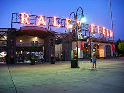
Sacramento has three other professional teams. Sacramento Republic FC began play in April 2014 at Hughes Stadium before a sellout crowd of 20,231, setting a USL Pro regular-season single game attendance record.[71][72] The Republic FC won the USL championship in their first season. In 2000, AAA minor league baseball returned to Sacramento with the Sacramento River Cats, an affiliate of the San Francisco Giants and formerly an affiliate of the Oakland Athletics. The River Cats play in Raley Field, in West Sacramento. The Sacramento Express plays at Bonney Field in the newly formed PRO Rugby competition which kicked off in 2016.
Sacramento is the former home of two professional basketball teams. The Sacramento Heatwave of the American Basketball Association previously played in the Sacramento area until 2013. Sacramento was also formerly home to the now defunct Sacramento Monarchs of the WNBA. The Monarchs were one of the eight founding members of the WNBA in 1997 and won the WNBA Championship in 2005, but folded in November 2009.
| Club | League | Sport | Venue | Attendance | Established | Championships |
|---|---|---|---|---|---|---|
| Sacramento Kings | NBA | Basketball | Golden 1 Center | 16,291 | 1945 (1985) | 1 NBA, 2 NBL (as Rochester Royals) |
| Sacramento Republic FC | USL (D3) | Soccer | Bonney Field | 13,763 | 2012 | 1 USL Pro |
| Sacramento River Cats | PCL (AAA) | Baseball | Raley Field | 8,435 | 1978 (2000) | 2 Triple-A titles, 4 League titles |
| Sacramento Express | PRO Rugby | Rugby union | Bonney Field | — | 2016 | — |
Other sports

Sacramento has frequently hosted the NCAA Men's Outdoor Track and Field Championship as well as the 1st and 2nd rounds of the NCAA Men's Division I Basketball Championship. The California International Marathon (est. 1983) attracts a field of international elite runners who vie for a share of the $50,000 prize purse. The fast course is popular for runners seeking to achieve a Boston Marathon qualifying time and fitness runners.
Parks and recreation
Sacramento boasts an extensive park system consisting of over 5,000 acres (2,023 ha) of parkland and recreation centers.[73] The city features a collection of smaller parks in the Downtown districts, including Crocker Park, Pioneer Landing and Southside Park. Popular parks outside the central core include American River Parkway which spans 23 miles along the American River, and William Land Park.
In its 2013 ParkScore ranking, The Trust for Public Land reported that Sacramento was tied with San Francisco and Boston for having the 3rd best park system among the 50 most populous U.S. cities.[74] ParkScore ranks city park systems by a formula that analyzes the city's median park size, park acres as percent of city area, the percent of residents within a half-mile of a park, spending of park services per resident, and the number of playgrounds per 10,000 residents.
Sacramento is a hotbed for high school rugby. Jesuit High is the recent defending national champion (winning five times in total). Their arch-rival school Christian Brothers came in second nationwide. Burbank, Del Campo and Vacaville have also placed well in the national competition over the years. The Sacramento Valley High School Rugby Conference hosts the largest and arguably deepest preseason youth and high school rugby tournament in America.
Sacramento hosts some recreational facilities and events. The Jedediah Smith Memorial Trail that runs between Old Sacramento and Folsom Lake grants access to the American River Parkway, a natural area that includes more than 5,000 acres (20 km2) of undeveloped land. It attracts cyclists and equestrians from across the state. The California State Fair is held in Sacramento each year at the end of the summer, ending on Labor Day. In 2010, the State Fair moved to July. More than one million people attended this fair in 2001.
Among other recreational options in Sacramento is Discovery Park, a 275-acre (1.1 km2) park studded with stands of mature trees and grasslands. This park is situated where the American River flows into the Sacramento River.
In amateur sports, Sacramento claims many prominent Olympians such as Mark Spitz, Debbie Meyer (6 time gold medalist in for US swimming), Mike Burton, Summer Sanders (Gold medalist in swimming, and trained in childhood by Debbie Meyer at Rio Del Oro Racquet Club), Jeff Float (all swimming), and Billy Mills (track). Coach Sherm Chavoor founded his world-famous Arden Hills Swim Club just east of the city and trained Burton, Spitz and others.
Government and politics
The government of Sacramento operates as a charter city (as opposed to a general law city) under the Charter of the City of Sacramento. The elected government is composed of the Sacramento City Council with 8 city council districts and the Mayor of Sacramento, which operate under a mayor-council government. In addition, there are numerous departments and appointed officers such as the City Manager, Sacramento Police Department (SPD), the Sacramento Fire Department (SFD), City Clerk, City Attorney, and City Treasurer. As of 2015, the mayor is Kevin Johnson and the council members are Angelique Ashby, Allen Warren, Jeff Harris, Steve Hansen, Jay Schenirer, Rich Jennings, and Larry Carr.[4]
County government
The City of Sacramento is part of Sacramento County, for which the government of Sacramento County is defined and authorized under the California Constitution, California law, and the Charter of the County of Sacramento.[75] Much of the government of California is in practice the responsibility of county governments, such as the Government of Sacramento County. The county government provides countywide services such as elections and voter registration, law enforcement, jails, vital records, property records, tax collection, public health, and social services. The government of Sacramento County is composed of the elected five-member Board of Supervisors, several other elected offices, including the Sheriff, District Attorney, and Assessor, and numerous county departments and entities under the supervision of the County Executive Officer. Sacramento is located within all of the supervisorial districts, currently represented by Phil Serna, Jimmie R. Yee, Susan Peters, Roberta MacGlashan, and Don Nottoli. The other officials elected in part by Sacramento residents currently include Sheriff Scott Jones, District Attorney Anne Marie Schubert, and Assessor Kathleen Kelleher. In addition, several other entities of the government of California have jurisdiction conterminous with Sacramento County, such as the Sacramento County Superior Court.
Federal and state representation
In the California State Senate, Sacramento is the heart of the 6th district, represented by Democrat Richard Pan.[76] In the California State Assembly, it is split between the 7th Assembly District, represented by Democrat Kevin McCarty, and the 9th Assembly District, represented by Democrat Jim Cooper.[77]
In the United States House of Representatives, Sacramento forms the majority of the California's 6th congressional district, represented by Democrat Doris Matsui.[78]
Education
Colleges and universities
The Sacramento area hosts a wide variety of higher educational opportunities. There are two major public universities, many private institutions, community colleges, vocational schools, and McGeorge School of Law.
Public
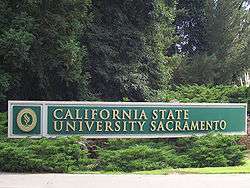
Sacramento is home to Sacramento State (California State University, Sacramento), founded as Sacramento State College in 1947. In 2004, enrollment was 22,555 undergraduates and 5,417 graduate students in the university's eight colleges. The university's mascot is the hornet, and the school colors are green and gold. The 300 acres (1.2 km2) campus is located along the American River Parkway a few miles east of downtown.
The University of California has a campus, UC Davis, in nearby Davis and has a graduate center in downtown Sacramento. The UC Davis Graduate School of Management (GSM) is near the UC Davis Medical Center off of Stockton Boulevard near Highway 50. Many students, about 400 out of 517, at the UC Davis GSM are working professionals and are completing their MBA part-time.[79] The part-time program is ranked in the top-20 and is well known for its small class size, world class faculty, and involvement in the business community. UC also maintains the University of California Sacramento Center (UCCS)[80] for undergraduate and graduate studies. Similar to the UC's Washington, D.C., program, "Scholar Interns" engage in both academic studies and as well as internships, often with the state government. The UC Davis School of Medicine is located at the UC Davis Medical Center between the neighborhoods of Elmhurst, Tahoe Park, and Oak Park.
The Los Rios Community College District consists of several two-year colleges in the Sacramento area—American River College, Cosumnes River College, Sacramento City College, Folsom Lake College, plus a large number of outreach centers for those colleges. Sierra College is on the outskirts of Sacramento in Rocklin.
Private, not for profit
University of the Pacific has its Sacramento Campus in the Oak Park neighborhood of Sacramento. The campus houses McGeorge School of Law, a top 100 law school according to U.S. News & World Report's annual rankings of U.S. law schools (2006, 2007 & 2008). In 2015, the campus was expanded to become a comprehensive graduate and professional campus, including programs in analytics, business, education, health sciences, and public policy.[81]
The National University Sacramento regional campus offers bachelor's and master's degrees in business, education, health-care and teaching credential programs.
The University of San Francisco has one of its four regional campuses in Sacramento. At the undergraduate level they offer degrees in Applied Economics, Information Systems, Organizational Behavior and Leadership, and Public Administration. At the graduate level, Master's programs are offered in: Information Security and Assurance, Information Systems, Organization Development, Project Management, Public Administration, Nonprofit Administration, and Counseling.[82]
The private University of Southern California has an extension in downtown Sacramento, called the State Capital Center. The campus, taught by main campus professors, Sacramento-based professors, and practitioners in the State Capitol and state agencies, offers Master of Public Administration, Masters of Public Policy, and Master of Public Health degrees.[83]
Epic Bible College and the Professional School of Psychology are also based in Sacramento.
Western Seminary has one of its four campuses in Sacramento, which opened on the campus of Arcade Church in 1991. Western is an evangelical, Christian graduate school that provides theological training for students who hope to serve in a variety of ministry roles including pastors, marriage and family therapists, educators, missionaries and lay leadership. The Sacramento campus offers four master's degrees, and a variety of other graduate-level programs.[84]
Private, for profit
Sacramento has a number of private vocational schools as well.
A satellite campus of Alliant International University offers graduate and undergraduate programs of study.
The Art Institute of California – Sacramento was established in 2007, and is a branch of The Art Institute of California – Los Angeles. The school is focused on educating students in the field of commercial arts. The school offers both a Bachelor of Science and an Associate of Science degree, as well as diplomas in some areas of study. Some majors the school offers are Digital Film-making & Video Production, Culinary Management, Graphic Design, and Game Art & Design.
On J Street, there is the Lincoln Law School of Sacramento, a private, evening-only law school program with a strong legal presence in the region.
The Universal Technical Institute (UTI) is in Sacramento; it offers automotive programs in auto mechanical, auto body, and diesel.
K–12 schools
The Sacramento Public Library system has 28 branches located in the greater area. The Sacramento area is served by various public school districts, including the Sacramento City Unified School District, Natomas Unified School District, San Juan Unified School District, Twin Rivers Unified School District, and Elk Grove Unified School District. As of 2009, the area's schools employed 9,600 elementary school teachers (not including special education teachers),[85] and 7,410 middle school teachers (not including special education or vocational teachers).[86]
Public schools
Almost all areas south of the American River are served by the Sacramento City Unified School District. The only exceptions are the Valley Hi/North Laguna and Florin areas that are served by the Elk Grove Unified School District.
Areas north of the American River are served by the remaining school districts. This area was not originally part of the City of Sacramento and as such is not served by Sacramento City Unified School District. North Sacramento outside of Natomas and Robla (for K-8) is served by the Twin Rivers Unified School District. The Robla area is served by the Robla School District for K-8 and by Twin Rivers for 9–12. The Natomas region is served by the Natomas Unified School District. The Campus Commons area and the small portions of the Sierra Oaks neighborhood that fall into the city of Sacramento are served by the San Juan Unified School District.
Private schools
Independent schools
While Roman Catholic institutions still dominate the independent school scene in the Sacramento area, in 1964, Sacramento Country Day School opened and offered Sacramento citizens an independent school that is affiliated with the California Association of Independent Schools. SCDS has grown to its present-day status as a learning community for students from pre-kindergarten through twelfth grade. Additionally, the suburb of Fair Oaks hosts the expansive riverside campus of the Sacramento Waldorf School, a Steiner school adjacent to the Rudolf Steiner College, and the largest Waldorf school in North America. Sacramento Waldorf School educates students from pre-K through 12th grade on a secluded, pastoral site that incorporates a large, functioning biodynamic farm.
Other religious schools
Shalom School is the only Jewish day school in Sacramento; however, Brookefield School on property owned by Congregation B'nai Israel provides extracurricular Jewish education.
Capital Christian School is a pre-school–12th grade private, Christian school.[87] There is a small Bible college on campus offering associate degrees in Bible studies or theology. Sacramento Adventist Academy is another Christian school in Greater Sacramento. This is a pre-school–12 institution, as well.
There is one Islamic school in Sacramento, Masjid Annur, founded in 1988.
Media
Magazines
Newspapers
- Top two newspapers
- The Sacramento Bee, the primary newspaper, was founded in 1857 by James McClatchy. The Sacramento Bee is the flagship paper of The McClatchy Company, the second-largest newspaper publisher in the United States. The Sacramento Bee has won five Pulitzer Prizes in its history and numerous other awards, including many for its progressive public service campaigns promoting free speech (the Bee often criticized government policy, and uncovered many scandals hurting Californians), anti-racism (the Bee supported the Union during the American Civil War and later publicly denounced the Ku Klux Klan), worker's rights (the Bee has a strong history of supporting unionization), and environmental protection (leading numerous tree-planting campaigns and fighting against environmental destruction in the Sierra Nevada).
- The Sacramento Union, the Sacramento Bee's rival, started publishing six years earlier in 1851; it closed its doors in 1994, with a revival attempt lasting from 2005 to 2009. Writer and journalist Mark Twain wrote for the Union in 1866.
- Other newspapers
Radio
Television stations
| Channel | Call Sign | Network |
|---|---|---|
| 3 | KCRA-TV | NBC |
| 6 | KVIE | PBS |
| 10 | KXTV | ABC |
| 13 | KOVR | CBS (O&O) |
| 19 | KUVS-DT | Univision (O&O) |
| 27 | TBA | 3ABN |
| 29 | KSPX-TV | Ion (O&O) |
| 31 | KMAX-TV | CW (O&O) |
| 32 | KSTV-LP | Azteca |
| 33 | KCSO-LD | Telemundo |
| 40 | KTXL | Fox |
| 58 | KQCA | MyNetworkTV |
| 64 | KTFK | Telefutura (O&O) |
Transportation
Roads and highways
The Sacramento region is served by several highways and freeways. Interstate 80 (I-80) is the major east-west route, connecting Sacramento with San Francisco in the west, and Reno in the east. Business 80 (the Capital City Freeway) splits from I-80 in West Sacramento, runs through Sacramento, and then rejoins its parent in the northwest portion of the city. U.S. Highway 50 also begins its eastern journey in West Sacramento, co-signed with Business 80, but then splits off and heads toward South Lake Tahoe as the El Dorado Freeway.
Interstate 5 (I-5) runs though Sacramento, heads north up to Redding, and then heads south near the western edge of the California Central Valley towards Los Angeles. California State Highway 99 runs through Sacramento, heading closer to the eastern edge of the Central Valley, connecting to Marysville and Yuba City in the north, and Fresno and Bakersfield in the south. California State Highway 160 approaches the city after running along the Sacramento River from Contra Costa County in the south, and then becomes a major city street in Downtown Sacramento before turning into the North Sacramento Freeway, going over the American River to Business 80.
Some Sacramento neighborhoods, such as Downtown Sacramento and Midtown Sacramento are very bicycle friendly as are many other communities in the region. As a result of litigation, Sacramento has undertaken to make all city facilities and sidewalks wheelchair accessible. In an effort to preserve its urban neighborhoods, Sacramento has constructed traffic-calming measures in many areas.
Amtrak service
Amtrak provides passenger rail service to the city of Sacramento. The Sacramento Valley Rail Station is on the corner of 5th and I streets near the historic Old Town Sacramento and underwent extensive renovations in 2007. The station serves as a Regional Transit light rail terminus.
Amtrak California operates the Capitol Corridor, a multiple-frequency service providing service from the capital city to its northeastern suburbs and the San Francisco Bay Area.[88]
Sacramento is the northern terminus of the Amtrak California San Joaquins route which provide direct multiple-frequency passenger rail service to California's Central Valley as far as Bakersfield; Thruway Motorcoach connections are available from the trains at Bakersfield to Southern California and Southern Nevada.
Sacramento is a stop along Amtrak's Coast Starlight route which provides scenic service to Seattle via Klamath Falls and Portland to the north and to Los Angeles via San Luis Obispo and Santa Barbara to the south.
Amtrak's California Zephyr serves Sacramento daily and provides service to the east serving Reno, Salt Lake, Denver, Omaha, Chicago and intermediate cities.
The Sacramento Valley Rail Station provides numerous Thruway Motorcoach routes. One route serves the cities of Marysville, Oroville, Chico, Corning, Red Bluff and Redding with additional service to Yreka and even Medford, Oregon. A second serves the cities of Roseville, Rocklin, Auburn, Colfax, Truckee, Reno and Sparks. The third and final thruway motorcoach route serves Placerville, Lake Tahoe, Stateline Casinos, and Carson City, Nevada. Each of these routes provides multiple frequencies each day.
Sacramento has the second busiest Amtrak station in California and the seventh busiest in the country.
Walkability
A 2011 study by Walk Score ranked Sacramento 24th most walkable of fifty largest U.S. cities.[89]
Airport
Sacramento International Airport
Sacramento International Airport (IATA: SMF, ICAO: KSMF, FAA LID: SMF) is a public airport 10 miles (16 km) northwest of downtown Sacramento, in Sacramento County, California. It is run by Sacramento County. Southwest Airlines currently accounts for half the airline passengers. Other airlines include Delta, United, American Airlines and Alaska. In 2015, the airport handled 9,608,948 passengers, an increase of 7.1% from 8,972,956 passengers in 2014.
Sacramento International Airport handles flights to and from various US destinations (including Hawaii) as well as Mexico, Canada and connecting flights to Europe, Asia, and South America.
The airport is best known for its red rabbit installation by Lawrence Argent entitled "Leap".[90]
Other transportation options
The city and its suburbs are served by Sacramento Regional Transit District, which ranks as the eleventh busiest in the United States. Sac RT is a bus and light-rail system, with 274 buses and 76 light-rail vehicles providing service for 58,200 daily passengers. The three Light-rail lines (Blue, Gold, & Green) is a 42.9 mi (69.0 km)[1] system with 54 stations. The Gold Line was extended east as far as the city of Folsom, and more recently the Blue Line was extended south from Meadowview Rd to Cosumnes River College. Sacramento's light rail system goes to the Sacramento Valley Rail Station, Cosumnes River College (Sacramento RT) in south Sacramento, and north to Watt/I-80 where I-80 and Business 80 meet. The Light-rail Blue & Gold Lines have 15 minute weekday headways and 30 minute weekday evening and weekend/holiday headways; the Green Line has 30 minute weekday headways and no weekend service. There are expansion plans to extend the Green Line to Sacramento International Airport and the Blue Line to the City of Roseville, California through the City of Citrus Heights, California. Also, there is a planned street car line to connect downtown Sacramento with the City of West Sacramento, California. Yolobus provides bus service to West Sacramento and Yolo County.
Greyhound Lines provides intercity bus service to Portland, Reno, Los Angeles, and San Francisco from its new station along Richards Boulevard. Intercity bus service to San Francisco and Sparks, Nevada is offered by Megabus.[91]
Bicycling is an increasingly popular transportation mode in Sacramento, which enjoys a mild climate and flat terrain. Bicycling is especially common in the older neighborhoods of Sacramento's center, such as Alkali Flat, Midtown, McKinley Park, Land Park, and East Sacramento. Many employees who work downtown commute by bicycle from suburban communities on a dedicated bicycle path on the American River Parkway. Sacramento was designated as a Silver Level Bicycle Friendly Community by the League of American Bicyclists in September 2006. The advocacy organization Sacramento Area Bicycle Advocates co-sponsors the Sacramento Area Council of Governments' May is Bike Month campaign.
There is commuter bus service from Yolo County on Yolobus, from Solano County on FAST, on two bus lines from Yuba County's Yuba Sutter Transit,[92] from Amador Transit's Sacramento Line,[93] on Placer County Transit's Auburn to Light Rail Line,[94] and from San Joaquin County on several SMART bus lines.
Cemeteries
- Odd Fellows Lawn Cemetery and Mausoleum[95]
- Sacramento Historic City Cemetery[96]
Notable residents
Sister cities
As of 2015, the City of Sacramento has 12 sister cities. They are:[97]
| Country | City | Year of Partnership |
|---|---|---|
| |
Ashkelon | August 15, 2012 |
| |
Bethlehem | December 15, 2009 |
| |
Chişinău[98] | December 12, 1989 |
| |
Hamilton | December 6, 1988 |
| |
Jinan, Shandong | October 16, 1984 |
| |
Liestal | March 21, 1989 |
| |
Manila | June 8, 1961 |
| |
Matsuyama, Ehime | March 17, 1981 |
| |
Mexicali | |
| |
Pasay City | February 28, 2006 |
| |
San Juan de Oriente | February 28, 2006 |
| |
Yongsan-gu, Seoul | July 22, 1997 |
| |
Valencia | July 12, 1990 |
See also
- List of cities and towns in California
- List of largest California cities by population
- List of mayors of Sacramento, California
- List of people from Sacramento, California
- Sacramento Metropolitan Fire District
- University Arboretum at California State University, Sacramento
Notes
References
- ↑ "California Cities by Incorporation Date" (Word). California Association of Local Agency Formation Commissions. Retrieved August 25, 2014.
- ↑ "City Hall". City of Sacramento. Retrieved February 23, 2015.
- ↑ "City Hall". City of Sacramento. Retrieved February 28, 2015.
- 1 2 3 "Mayor & Council". City of Sacramento. Retrieved December 14, 2014.
- ↑ "2010 Census U.S. Gazetteer Files – Places – California". United States Census Bureau.
- ↑ "Sacramento". Geographic Names Information System. United States Geological Survey. Retrieved January 28, 2013.
- 1 2 3 "American FactFinder – Results". United States Census Bureau. Retrieved May 23, 2015.
- ↑ "American Fact Finder – Results". United States Census Bureau. Retrieved April 17, 2015.
- ↑ "American Fact Finder – Results". United States Census Bureau. Retrieved April 6, 2015.
- 1 2 "American Fact Finder – Results". United States Census Bureau. Retrieved April 6, 2015.
- ↑ "Top 50 Cities in the U.S. by Population and Rank". www.infoplease.com. Retrieved 2016-06-29.
- 1 2 Stodghill, Ron (August 25, 2002). "Welcome to America's Most Diverse City". TIME. Retrieved July 20, 2013.
- ↑ "Cathedral of the Blessed Sacrament – Sacramento, California". Cathedralsacramento.org. November 11, 2012. Retrieved November 16, 2012.
- 1 2 "Old Sacramento, California – Walking on History". Retrieved October 2, 2014.
- ↑ "About the City of Sacramento". Cityofsacramento.org. Retrieved November 16, 2012.
- ↑ "Sacramento's Chinatown – News – Local Stories – June 28, 2007 – Sacramento News & Review". Newsreview.com. Retrieved November 16, 2012.
- ↑ "Friends Of the Yee Fow Museum". Yeefowmuseum.org. Retrieved November 16, 2012.
- ↑ "An Evidentiary Timeline on the History of Sacramento's Chinatown". Yeefow.com. Retrieved November 16, 2012.
- ↑ "Status quo for city governance?". Sacramento Bee. September 26, 2009.
- ↑ Editorial Board (September 26, 2012). "Endorsements: Michael Picker is best pick for SMUD Ward 5". Sacramento Bee. Retrieved November 21, 2012.
- ↑ "UARP Relicensing Public Participation Community Oriented Utility". Hydrorelicensing.smud.org. Retrieved November 16, 2012.
- ↑ Don Stanle (July 30, 1989). "1920s A Wet Prohibition, A City Of North Sac, The First Woman Mayor". Sacramento Bee. p. 27.
|section=ignored (help) - ↑ "Sacramento (detention facility)". Densho Encyclopedia. Retrieved August 8, 2014.
- ↑ Avella, Steven M. (2003). Sacramento: Indomitable City. Arcadia Publishing. p. 124. ISBN 0-7385-2444-1.
- ↑ "American FactFinder". Factfinder.census.gov. Retrieved November 16, 2012.
- ↑ Stodghill, Ron; Bower, Amanda (August 25, 2002). "Welcome to America's Most Diverse City". Time.
- ↑ "Sacramento Background". Vcarious.com. Retrieved November 16, 2012.
- ↑ "Sacramento Vacation Information | Hotels, Restaurants, Events, and Things to Do". www.visitsacramento.com. Retrieved 2015-11-16.
- ↑ Area 1
- ↑ Area 2 Archived September 26, 2011, at the Wayback Machine.
- ↑ Area 3 Archived September 26, 2011, at the Wayback Machine.
- ↑ Area 4 Archived September 26, 2011, at the Wayback Machine.
- ↑ "City of Sacramento: Neighborhoods" (PDF). Cityofsacramento.org. Retrieved November 16, 2012.
- ↑ "Community info: neighborhoods, schools, homes for rent, property management". Horizon Properties. Retrieved November 16, 2012.
- 1 2 3 "NowData - NOAA Online Weather Data". National Oceanic and Atmospheric Administration. Retrieved December 6, 2012.
- ↑ "Forecasters Say Snow Possible In Sacramento". capradio.org. February 24, 2011. Retrieved November 16, 2012.
- ↑ "Snow in Sacramento". YouTube. December 19, 2009. Retrieved November 16, 2012.
- ↑ "Arctic Blast Could Bring Dusting Of Snow To Sacramento Valley and Several Feet To Sierra" CBS Sacramento
- ↑ "SACRAMENTO 5 ESE, CALIFORNIA". Western Regional Climate Center. Retrieved October 24, 2012.
- ↑ "How the West May Flood: Winter's Long, Long Reach". Time. June 27, 2011.
- ↑ Osborn, Liz. "Sunniest Places and Countries in the World". Current Results. Retrieved November 16, 2012.
- ↑ ThreadEx
- 1 2 "NowData – NOAA Online Weather Data". National Oceanic and Atmospheric Administration. Retrieved 2016-04-19.
- ↑ "WMO Climate Normals for SACRAMENTO/EXECUTIVE ARPT CA 1961–1990". National Oceanic and Atmospheric Administration. Retrieved 2014-03-11.
- ↑ "SACRAMENTO 5 ESE, CALIFORNIA". Western Regional Climate Center.
- ↑ "Annual Estimates of the Resident Population for Incorporated Places: April 1, 2010 to July 1, 2015". Retrieved July 2, 2016.
- ↑ "Census of Population and Housing". Census.gov. Retrieved June 4, 2015.
- 1 2 "Sacramento (city), California". State & County QuickFacts. U.S. Census Bureau. Retrieved April 21, 2012.
- 1 2 3 4 "California – Race and Hispanic Origin for Selected Cities and Other Places: Earliest Census to 1990". U.S. Census Bureau. Retrieved April 21, 2012.
- 1 2 From 15% sample
- ↑ "2010 Census Interactive Population Search: CA – Sacramento city". U.S. Census Bureau. Retrieved July 12, 2014.
- ↑ "American Factfinder". census.gov. Retrieved August 27, 2011.
- ↑ "12.9% in Seattle are gay or bisexual, second only to S.F., study says". The Seattle Times. November 15, 2006. Retrieved June 13, 2013.
- ↑ "American FactFinder". United States Census Bureau. Retrieved 2008-01-31.
- ↑ The Geography of U.S. Diversity (PDF). United States Census. Retrieved on June 15, 2007.
- ↑ "City of Sacramento Comprehensive Annual Financial Report, Fiscal Year Ended June 30, 2012" (PDF). City of Sacramento. p. 194. Retrieved April 20, 2015.
- 1 2 Sacramento Archives and Museum Collection Center and the Historic Old Sacramento Foundation. Old Sacramento and Downtown. Arcadia, 2006, 20.
- ↑ Sacramento Archives and Museum Collection Center and the Historic Old Sacramento Foundation. Old Sacramento and Downtown. Arcadia, 2006, 23.
- ↑ Sweeney, Adam (September 14, 2011). "Exclusive Interview: Colin Hanks". Playmaker. Retrieved July 20, 2013.
- a "I was born and raised in Sacramento, California, which most people don't know is where Tower started and was based until the end." — ¶ 4.
- ↑ "Deathwish Inc". Deathwish Inc. Retrieved November 16, 2012.
- ↑ "Trash Talk's anthology 'Shame' is released this week, Band Of The Week is in the bag!". Rock Sound. May 18, 2010. Retrieved June 20, 2010.
- ↑ Diver, Mike (May 5, 2010). "Trash Talk Eyes & Nines Review". BBC. Retrieved June 20, 2010.
- ↑ "SJFF Home". Sacjapanesefilmfestival.net. July 13, 2012. Retrieved November 16, 2012.
- ↑ Pham, Jason (February 27, 2015). "Grown-up slumber party, Trash Film Orgy overtake downtown art center". Sactown Magazine. Retrieved March 1, 2015.
- ↑ Meyer, Carla (October 15, 2007). "Horror film fest to debut in Sac". The Sacramento Bee. Retrieved March 1, 2015.
- ↑ Macias, Chris (October 30, 2012). "Sacramento's farm-to-fork moniker to be official – Food & Wine – The Sacramento Bee". Sacbee.com. Retrieved November 16, 2012.
- ↑ Macias, Chris. "Appetizers: The Kitchen, former Sacramento chef receive James Beard nominations". Blogs.sacbee.com. Retrieved November 16, 2012.
- ↑ "Premier Italian Restaurant | Sacramento Italian Restaurant | Home of Biba Caggiano". Biba Restaurant. October 12, 2012. Retrieved November 16, 2012.
- ↑ "Maloofs sell Kings to Hansen-led Seattle group". NBA.com. January 21, 2013. Retrieved February 19, 2013.
- ↑ "Seattle group has filed for relocation". AP on ESPN.com. February 6, 2013. Retrieved February 6, 2013.
- ↑ "Republic FC loses home opener before sellout crowd at Hughes Stadium", Sacramento Bee, April 27, 2014.
- ↑ "Sacramento Republic FC opener sells out, sets league record", Sacramento Bee, April 25, 2014.
- ↑ Warner, Anmargaret. (6 June 2013). [www.businessinsider.com/us-cities-with-the-best-parks-2013-6?op=1 "New York Parks Rank No. 2 in a Survey of 50 U.S. cities"]. Business Insider. Accessed 15 July 2013.
- ↑ Lindelof, Bill. "Capitol rated highly for its parks". 6 June 2013. The Sacramento Bee. Retrieved on 15 July 2013.
- ↑ California Government Code § 23004
- ↑ "Statewide Database". UC Regents. Retrieved November 7, 2014.
- ↑ "Communities of Interest – City". California Citizens Redistricting Commission. Retrieved November 6, 2014.
- ↑ "California's 6th Congressional District - Representatives & District Map". Civic Impulse, LLC. Retrieved March 8, 2013.
- ↑ Archived September 27, 2011, at the Wayback Machine.
- ↑ "Welcome — University of California Center Sacramento". Uccs.universityofcalifornia.edu. Retrieved November 16, 2012.
- ↑ "University of the Pacific to launch five new graduate programs in Sacramento". Retrieved 2015-07-03.
- ↑ Archived March 11, 2010, at the Wayback Machine.
- ↑ "USC Price School in Sacramento – USC Price School of Public Policy". Usc.edu. Retrieved November 16, 2012.
- ↑ "Western Seminary Sacramento Campus". www.westernseminary.edu. Retrieved November 26, 2013.
- ↑ "Sacramento, Arden, Arcade, Roseville CA – Elementary School Teachers (Excluding Special Education) – Career, Salary & Employment Info".
- ↑ "Sacramento, Arden, Arcade, Roseville CA – Middle School Teachers (Excluding Special & Vocational Education) – Career, Salary & Employment Info".
- ↑ "Capital Christian Center | Truth – Growth – Love". Ccconline.cc. Retrieved November 16, 2012.
- ↑ Archived February 25, 2009, at the Wayback Machine.
- ↑ "2011 City and Neighborhood Rankings". Walk Score. 2011. Retrieved August 28, 2011.
- ↑ "Sacramento airport's big red rabbit means business – really". sacbee. Retrieved November 15, 2015.
- ↑ "Low-cost Megabus.com gets service rolling Wednesday". bizjournals.com. December 11, 2012.
- ↑ "Commuter and Midday Express Services". Yubasuttertransit.com. Retrieved November 16, 2012.
- ↑ "Amador Transit Route 1: Sacramento". amadortransit.com. Retrieved November 15, 2015.
- ↑ Placer County Transit
- ↑ "Odd Fellows Lawn Cemetery and Mausoleum". Oddfellows-cmtry-sac.com.
- ↑ "Old City Cemetery Committee, Inc., Sacramento, California". Old City Cemetery Committee, Inc. 2005. Retrieved November 4, 2015.
- ↑ "Sacramento, California". Sister Cities International. Archived from the original on February 21, 2015. Retrieved February 21, 2015.
- ↑ "Oraşe înfrăţite (Twin cities of Minsk) [via WaybackMachine.com]" (in Romanian). Primăria Municipiului Chişinău. Archived from the original on September 3, 2012. Retrieved 2013-07-21.
External links
- Official website
- Official tourism website from the Sacramento Convention and Visitors Bureau
- Sacramento Wiki

| |||||||||||||||||||||||||||||||||||||||||||||||||||||||||||||||||||||||||||||||||