Richmond, California
| Richmond | ||
|---|---|---|
| City | ||
|
Point Richmond seen from nearby Nicholl Knob | ||
| ||
| Motto: The City of Pride and Purpose | ||
 Location in Contra Costa County | ||
 Richmond Location in the United States | ||
| Coordinates: 37°56′09″N 122°20′52″W / 37.93583°N 122.34778°WCoordinates: 37°56′09″N 122°20′52″W / 37.93583°N 122.34778°W | ||
| Country |
| |
| State |
| |
| County | Contra Costa | |
| Incorporated | August 7, 1905[1] | |
| Government | ||
| • Type | Council-Manager[2] | |
| • Body |
City council:[3] Tom Butt (D) (mayor), Jovanka Beckles, Nathaniel Bates, Eduardo Martinez, Gayle McLaughlin, and Jael Myrick | |
| • Supervisor |
District 1: John Gioia | |
| • State senator | Nancy Skinner (D)[4] | |
| • Assemblymember | Tony Thurmond (D)[5] | |
| • U. S. rep. | Mark DeSaulnier (D)[6] | |
| Area[7] | ||
| • City | 52.480 sq mi (135.923 km2) | |
| • Land | 30.068 sq mi (77.875 km2) | |
| • Water | 22.412 sq mi (58.048 km2) 42.71% | |
| Elevation[8] | 46 ft (14 m) | |
| Population (April 1, 2010)[9] | ||
| • City | 103,701 | |
| • Estimate (2014)[10] | 108,565 | |
| • Rank |
2nd in Contra Costa County 61st in California | |
| • Density | 2,000/sq mi (760/km2) | |
| • Urban | 28,038 | |
| • Metro[11] | 4,335,391 | |
| Time zone | Pacific (UTC-8) | |
| • Summer (DST) | PDT (UTC-7) | |
| ZIP codes | 94801, 94802, 94804, 94805, 94807, 94808, 94850 | |
| Area code | 510 | |
| GNIS IDs[8][12][13] | 1659507, 2410939 | |
| FIPS code[8][13] | 06-60620 | |
| Website |
www | |

Richmond (/ˈrɪtʃmənd/ RICH-mənd) is a city in western Contra Costa County, California, United States. The city was incorporated on August 7, 1905.[14] Located in the eastern region of the San Francisco Bay Area, Richmond borders the cities of San Pablo, Albany, El Cerrito and Pinole in addition to the unincorporated communities of North Richmond, Hasford Heights, Kensington, El Sobrante, Bayview-Montalvin Manor, Tara Hills, and East Richmond Heights, and briefly San Francisco on Red Rock Island.
Under the McLaughlin Administration, Richmond was the largest city in the United States served by a Green Party mayor.[15] As of the 2010 U.S. Census, the city's population is at 103,710, making it the second largest city in the United States named Richmond. The largest, Richmond, Virginia, is the namesake of the California city.

History


The Ohlone Indians were the first inhabitants of the Richmond area, settling an estimated 5,000 years ago.[16]
The name "Richmond" appears to predate actual incorporation by more than fifty years. Edmund Randolph, originally from Richmond, Virginia, represented the city of San Francisco when California's first legislature met in San Jose in December 1849, and he became state assemblyman from San Francisco. His loyalty to the town of his birth caused him to persuade a federal surveying party mapping the San Francisco Bay to place the names "Point Richmond" and "Richmond" on an 1854 geodetic coast map, which was the geodetic map at the terminal selected by the San Francisco and San Joaquin Valley Railroad; and by 1899 maps made by the railroad carried the name "Point Richmond Avenue," designating a county road that later became Barrett Avenue, a central street in Richmond.
The Atchison, Topeka and Santa Fe Railroad had its terminus at Richmond.[17] The first post office opened in 1900.[17]
Richmond was founded and incorporated in 1905, carved out of Rancho San Pablo, from which the nearby town of San Pablo inherited its name. Until the enactment of prohibition in 1919, the city had the largest winery in the world;[18] the small abandoned village of Winehaven remains fenced off along Western Drive in the Point Molate Area. In the 1920s the Ku Klux Klan was active in the city. In 1930 the Ford Motor Company opened an assembly plant called Richmond Assembly Plant which moved to Milpitas in the 1960s. The old Ford plant has been a National Historic Place since 1988, and in 2004 was purchased by developer Eddie Orton[19] and has been converted into an events center (Ford Point Building – The Craneway).[20] The city was a small town at that time, until the onset of World War II which brought on a rush of migrants and a boom in the industrial sector. Standard Oil set up operations here in 1901, including a what is now the Chevron Richmond Refinery and tank farm, which are still operated by Chevron. There is a pier into San Francisco Bay south of Point Molate for oil tankers. The western terminus of the Santa Fe Railroad was established in Richmond with ferry connections at Ferry Point in the Brickyard Cove area of Point Richmond to San Francisco.

At the outset of World War II, the four Richmond Shipyards were built along the Richmond waterfront, employing thousands of workers, many recruited from all over the United States, including many African-Americans and women entering the workforce for the first time. Many of these workers lived in specially constructed houses scattered throughout the San Francisco Bay Area, including Richmond, Berkeley and Albany. A specially built rail line, the Shipyard Railway, transported workers to the shipyards. Kaiser's Richmond shipyards built 747 Victory and Liberty ships for the war effort, more than any other site in the U.S.[21] The city broke many records and even built one Liberty ship in a record five days. On average the yards could build a ship in thirty days. The medical system established for the shipyard workers at the Richmond Field Hospital eventually became today's Kaiser Permanente HMO.[22] It remained in operation until 1993 when it was replaced by the modern Richmond Medical Center hospital, that has subsequently expanded to a large multiple building campus.
Point Richmond was originally the commercial hub of the city, but a new downtown arose in the center of the city. It was populated by many department stores such as Kress, J.C. Penney, Sears, Macy's, and Woolworth's. During the war the population increased dramatically and peaked at around 120,000 by the end of the war. Once the war ended the shipyard workers were no longer needed, beginning a decades-long population decline. The Census listed 99,545 residents in 1950. By 1960 much of the temporary housing built for the shipyard workers was torn down, and the population dropped to about 71,000. Many of the people who moved to Richmond were black and came from the Midwest and South. Most of the white men were overseas at war, and this opened up new opportunities for ethnic minorities and women. This era also brought with it the innovation of daycare for children, as a few women could care for several dozen women's children, while most of the mothers went off to work in the factories and shipyards.

In the 1970s the Hilltop area including a large shopping mall was developed in the northern suburbs of the city; this further depressed the downtown area as it drew away retail clients and tenants. In the late 1990s and early 2000s the Richmond Parkway was built along the western industrial and northwestern parkland of the city connecting Interstates 80 and 580.
In the early 1900s, the Santa Fe railroad established a major rail yard adjacent to Point Richmond. The railroad constructed a tunnel through the Potrero San Pablo ridge to run a track from their yard to a ferry landing from which freight cars could be transshipped to San Francisco. Where this track crosses the main street in Point Richmond, there remain two of the last operational wigwag grade crossing signals in the United States, and the only surviving examples of the "upside-down" type. The wigwag is an antiquated type of railroad crossing signal which was phased out in the 1970s and 80s across the country. There was controversy in 2005 when the State Transportation Authority ordered the BNSF railroad company to upgrade the railroad crossing signals. A compromise was achieved that included installing new modern crossing gates, red lights and bells while not removing, but simply shutting off the historic ones and preserving their functionality for special events.[23]
The Pullman Company also established a major facility in Richmond in the early 20th century.[24] The facility connected with both the Santa Fe and Southern Pacific and serviced their passenger coach equipment. The Pullman Company was a large employer of African American men, who worked mainly as porters on the Pullman cars.[25][26] Many of them settled in the East Bay, from Richmond to Oakland, prior to World War II.
Martin Luther King, Jr. had planned to visit Richmond just prior to his assassination.[27]
In 2006 the city celebrated its centennial. This coincided with the repaving and streetscaping project of Macdonald Avenue. The city's old rundown commercial district along Macdonald has been designated the city's "Main Street District" by the state of California. This has led to funding of improvements in the form of state grants.[28]
Geography

Richmond is located at 37°56′09″N 122°20′52″W / 37.93583°N 122.34778°W.[8]
According to the United States Census Bureau, the city has a total area of 52.5 square miles (136 km2), of which 30.1 square miles (78 km2) is land and 22.4 square miles (58 km2) (42.71%) is water. The city sits on 32 miles (51 km) of waterfront, more than any other city in the Bay Area.[29] The city borders San Francisco Bay to the southwest and San Pablo Bay to the northwest, and includes Brooks Island and the Brother Islands entirely, and half of Red Rock Island.
There are several cities and unincorporated communities surrounding or bordering Richmond. To the south is the city of Albany which is in Alameda County and the city of El Cerrito. The unincorporated communities of East Richmond Heights, Rollingwood, Hasford Heights, and El Sobrante lie to the east. North Richmond to the west and San Pablo to the east are almost entirely surrounded by Richmond's city limits. To the north, Richmond borders the city of Pinole and the unincorporated areas of Bayview, Montalvin Manor, Hilltop Green, Tara Hills. Richmond borders Alameda, San Francisco, and Marin counties in the Bay and Red Rock Island.
The city is within the 94801, 94803, 94804, 94805, and 94806 ZIP Codes.[30]

Climate
Richmond, like much of the coastal East Bay, enjoys a very mild Mediterranean climate year round. The climate is slightly warmer than the coastal areas of San Francisco, the Peninsula, and Marin County; it is however more temperate than areas further inland. The average highs range from 57 to 73 °F (14 to 23 °C) and the lows between 43 to 56 °F (6 to 13 °C) year round.[31] Richmond usually enjoys an "Indian summer", and September is, on average, the warmest month. January is on average the coldest month.
The highest recorded temperature in Richmond was 107 °F (42 °C) in September 1971 while the coldest was 24 °F (−4 °C) in January 1990.[31]
The rainy season begins in late October and ends in April with some showers in May. Most of the rain occurs during stronger storms which occur between November and March and drop 3.3–4.91 inches (84–125 mm) of rain per month. January and February are the rainiest months.[31]
Like most of the Bay Area, Richmond is made up of several microclimates. Southern parts of the city and the ridges receive more fog than northern areas. Summer temperatures are higher in inland areas, where the moderating influence of San Francisco Bay is lessened. The average wind speed is 6–9 miles per hour (10–14 km/h) with stronger winds from March through August; the strongest winds are in June.[29] The city also enjoys more than 80% sunshine seven months out of the year and 10 with 60% or more. December and January are the darkest months with about 45% average brightness.[29] The city experiences virtually no snowfall, and brief hail annually. The city is very humid in the morning with the lowest humidity being in the high 70% range. This may be due to San Francisco Bay's notorious fog and also the fact that a majority of Richmond lies on a flat coastal plain predominantly consisting of reclaimed tidal marshes, inter-tidal flats, and seep.[32] Morning humidity is 75% to 92% year round; afternoon humidity is more variable. This percentage is in the high 20s to mid 30s (%) May through October (the summer months) and climbs or descends through 40% to 70% during the winter.[29]
| Climate data for Richmond, California (1981–2010 normals) | |||||||||||||
|---|---|---|---|---|---|---|---|---|---|---|---|---|---|
| Month | Jan | Feb | Mar | Apr | May | Jun | Jul | Aug | Sep | Oct | Nov | Dec | Year |
| Average high °F (°C) | 57.6 (14.2) |
61.1 (16.2) |
64.2 (17.9) |
66.8 (19.3) |
69.1 (20.6) |
72.1 (22.3) |
71.5 (21.9) |
72.3 (22.4) |
74.4 (23.6) |
72.1 (22.3) |
64.6 (18.1) |
57.7 (14.3) |
66.96 (19.43) |
| Average low °F (°C) | 43.5 (6.4) |
45.9 (7.7) |
47.5 (8.6) |
49.4 (9.7) |
52.2 (11.2) |
54.6 (12.6) |
55.7 (13.2) |
56.3 (13.5) |
56.3 (13.5) |
53.6 (12) |
48.8 (9.3) |
43.9 (6.6) |
50.64 (10.36) |
| Average precipitation inches (mm) | 4.79 (121.7) |
4.64 (117.9) |
3.45 (87.6) |
1.60 (40.6) |
0.77 (19.6) |
0.21 (5.3) |
0 (0) |
0.06 (1.5) |
0.17 (4.3) |
1.36 (34.5) |
3.19 (81) |
4.55 (115.6) |
24.80 (629.9) |
| Average precipitation days (≥ 0.01 in) | 10.5 | 10.0 | 9.3 | 5.3 | 3.1 | 0.9 | 0.1 | 0.2 | 1.2 | 3.3 | 7.3 | 9.4 | 60.6 |
| Source: NOAA [33] | |||||||||||||
Environment
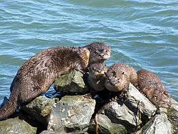
Richmond is home to many species of animals. Canada geese visit the city on their annual migrations. Harbor seals live in the Castro Rocks and pigeons and gulls populate the sidewalks and parking lots. Tadpoles and frogs can be found in the local creeks and vernal pools. Field mice and lizards are also found. Herons and egrets nest in protected areas on Brooks Island. Deer, falcons, raccoons, ducks, foxes, owls, and mountain lions live in Wildcat Canyon and Point Pinole Regional Shoreline.
A license is needed for fishing on the waterfront or city waters but not on the piers, where in addition to crabs, sturgeon are plentiful and manta rays may also be found. Striped bass, bat rays, leopard sharks, surf perch, jacksmelt, sturgeon, white croaker, and flounders are also found.[34] Richmond is one of the few places where you can find the rare Olympia oyster on the west coast, in the polluted waters along the refinery's shoreline. rainbow trout have recently returned to San Pablo and Wildcat creeks.[35]
Red-tailed hawks patrol the skies. Monarch butterflies migrate through the city on their journey between Mexico and Canada. Wildcat Marsh has two ponds where Canada geese often rest, and is also the home of the endangered salt marsh harvest mouse and California clapper rail. Another endangered species in the city is the Santa Cruz tarweed which survives alongside Interstate 80. Wildcat Canyon also hosts falcons and vultures. Threatened black rails also live in the city's marshes.[36]
After a baby grey whale was beached on the Point Richmond shore in May 2007, its rotting corpse became bothersome to neighbors. It took a while to remove it since various agencies argued over which would have to pay for it.[37][38][39][40]
Richmond is also home to one of the last pristine moist grassland habitats in the entire Bay Area at the former Campus Bay UC Berkeley Field Station near Meeker Slough.[41]
In 2006 the city was sued by an environmental group for dumping raw sewage into the Bay. Councilmember Tom Butt was very vocal on the subject accusing the city council of turning a blind eye to the problem.[42]
Mayor McLaughlin has set a goal of installing five megawatts of solar photovoltaic generation in Richmond.[43]
Crime
The city has in the past suffered from a high crime rate; at one point, the city council requested a declaration of a state of emergency and asked for the intervention of the Contra Costa County Sheriff and the California Highway Patrol.[44] Murder, vehicle theft, and larceny rates remain high, although they tend to be concentrated in the Iron Triangle and adjacent unincorporated North Richmond, which is outside the jurisdiction of the Richmond Police Department.
The city received widespread attention in 2009 when a girl was gang raped at a homecoming dance at Richmond High School.
In 2007, Richmond opened a program to prevent gun violence, the Office of Neighborhood Safety.[45] The program collects information and analyzes public records to determine "the 50 people in Richmond most likely to shoot someone and to be shot themselves." It then offers selected individuals "a spot in a program that includes a stipend to turn their lives around".[46] "Over an 18-month period, if the men demonstrate better behavior, ONS offers them up to $1,000 a month in cash, plus opportunities to travel beyond Richmond."[47]
In 2004, Richmond was ranked the 12th most dangerous city in America.[48] Those rankings have changed, and Richmond is no longer a ranked as a "most dangerous" city, in either California or the United States. This is in large part due to the efforts of Police Chief Chris Magnus, who established "community policing", which involves police officers engaging with affected high crime communities.[49]
Disasters
Richmond lies in the volatile California region that has a potential for devastating earthquakes. Many buildings were damaged in the 1989 Loma Prieta earthquake. There was also minor damage in the Richmond earthquake in 1995. The city has also had at least one minor tornado. The Chevron Richmond Refinery often releases gases and had many highly noted chemical leaks in the 1990s. The company has been fined thousands, sometimes hundreds of thousands of dollars. The chemicals most often released are chlorine and sulfur trioxide.[50] In a July 26, 1993, industrial accident, a General Chemical company rail tanker car containing oleum overheated and exploded in the General Chemical railyard. This resulted in a 17-mile (27 km) area contaminated with the poisonous gas, and led to 25,000 people landing in the hospital. The incident led to lawsuits, and has been referred to as a mini-Bhopal.[51]

The city's shoreline and wildlife were seriously affected by the 2007 San Francisco Bay oil spill. Beaches and shoreline were closed, but later reopened.[52] Keller Beach was closed to public access for swimmers.
On April 15, 2010, a sinkhole (roughly 30 feet (9.1 m) deep) appeared at the intersection of El Portal Drive and Via Verdi. Although no one was hurt, a car fell into the sinkhole.[53]
On August 6, 2012, a fire erupted in the Chevron refinery, resulting in 15,000 residents in the surrounding area to seek medical treatment.[54]
There are 17 emergency warning sirens in the city, they are tested every Wednesday and are usually used to warn of toxic chemical releases from the Chevron Richmond Refinery.[55]
Demographics
| Historical population | |||
|---|---|---|---|
| Census | Pop. | %± | |
| 1910 | 6,802 | — | |
| 1920 | 16,843 | 147.6% | |
| 1930 | 20,093 | 19.3% | |
| 1940 | 23,642 | 17.7% | |
| 1950 | 99,545 | 321.1% | |
| 1960 | 71,854 | −27.8% | |
| 1970 | 79,043 | 10.0% | |
| 1980 | 74,676 | −5.5% | |
| 1990 | 87,425 | 17.1% | |
| 2000 | 99,216 | 13.5% | |
| 2010 | 103,701 | 4.5% | |
| Est. 2015 | 109,708 | [56] | 5.8% |
2010
The 2010 United States Census[58] reported that Richmond had a population of 103,701. The population density was 1,976.0 inhabitants per square mile (762.9/km2). The racial makeup of Richmond was 32,590 (31.4%) White, 27,542 (26.6%) African American, 662 (0.6%) Native American, 13,984 (13.5%) Asian (4.0% Chinese, 3.5% Filipino, 1.6% Laotian, 1.2% Indian, 0.7% Vietnamese, 0.6% Japanese, 0.4% Korean, 0.2% Pakistani, 0.1% Thai), 537 (0.5%) Pacific Islander, 22,573 (21.8%) from other races, and 5,813 (5.6%) from two or more races. Hispanic or Latino of any race were 40,921 persons (39.5%). Among the Hispanic population, 27.3% were of Mexican origin, 4.7% Salvadoran, 1.7% Guatemalan, and 1.2% Nicaraguan heritage.
The census reported that 102,118 people (98.5% of the population) lived in households, 670 (0.6%) lived in non-institutionalized group quarters, and 913 (0.9%) were institutionalized.
There were 36,093 households, out of which 13,487 (37.4%) had children under the age of 18 living in them, 14,502 (40.2%) were opposite-sex married couples living together, 6,931 (19.2%) had a female householder with no husband present, 2,585 (7.2%) had a male householder with no wife present. There were 2,538 (7.0%) unmarried opposite-sex partnerships, and 427 (1.2%) same-sex married couples or partnerships. 9,546 households (26.4%) were made up of individuals and 2,707 (7.5%) had someone living alone who was 65 years of age or older. The average household size was 2.83. There were 24,018 families (66.5% of all households); the average family size was 3.43.
The population was spread out with 25,800 people (24.9%) under the age of 18, 10,364 people (10.0%) aged 18 to 24, 30,846 people (29.7%) aged 25 to 44, 26,109 people (25.2%) aged 45 to 64, and 10,582 people (10.2%) who were 65 years of age or older. The median age was 34.8 years. For every 100 females there were 94.8 males. For every 100 females age 18 and over, there were 92.0 males.
There were 39,328 housing units at an average density of 749.4 per square mile (289.3/km2), of which 18,659 (51.7%) were owner-occupied, and 17,434 (48.3%) were occupied by renters. The homeowner vacancy rate was 2.5%; the rental vacancy rate was 8.1%. 52,683 people (50.8% of the population) lived in owner-occupied housing units and 49,435 people (47.7%) lived in rented housing.
The African-American population in Richmond was 22% African-American as of 2015, while it was 44% African-American in 1990.[59]
|
2000
As of the census[61] of 2000, there were 99,216 people, 34,625 households, and 23,025 families in the city. The population density was 3,309.5 inhabitants per square mile (1,277.8/km2). There were 36,044 housing units at an average density of 1,202.3 per square mile (464.2/km2). The racial makeup of the city was 36.06% black or African American, 21.36% white, 0.64% Native American, 12.29% Asian, 0.50% Pacific Islander, 13.86% from other races, and 5.27% from two or more races. 26.53% of the population were Hispanic or Latino, of any race.
Of the 34,625 households, 33.7% had children under the age of 18 living with them, 40.5% were married couples living together, 20.1% had a female householder with no husband present, and 33.5% were non-families. 26.2% of all households were made up of individuals and 7.4% had someone living alone who was 65 years of age or older. The average household size was 2.82 and the average family size was 3.44.
In the city the population was spread out with 27.7% under the age of 18, 9.9% from 18 to 24, 31.4% from 25 to 44, 21.2% from 45 to 64, and 9.9% who were 65 years of age or older. The median age was 33 years. For every 100 females there were 94.6 males. For every 100 females age 18 and over, there were 91.2 males.
The median income for a household in the city was $44,210, and the median income for a family was $46,659. Males had a median income of $37,389 versus $34,204 for females. The per capita income for the city was $19,788. About 13.4% of families and 16.2% of the population were below the poverty line, including 23.1% of those under age 18 and 11.8% of those age 65 or over.
75.4% of inhabitants over the age of 25 were high school graduates, while 22.4% had bachelor's degrees, and 8.3% had a graduate or professional degree. 7.7% of the population was unemployed and those who were employed took, on average, 34.3 minutes to commute to their place of work.[29]
33.2% of the population aged 15 and over has never married, while 46.3% is currently wed. 11.1% have already divorced, 3.1% is currently separated, and 6.4% has been widowed.[29]
20.6% of the population was born outside the U.S., of which 15.4% were born in Latin America and 8.7% in Asia.[29]
During the day the population shrinks by 6.2% due to commuting while 23.3% of the population works within the city limits. 20.5% of the jobs in the city are in the educational, health, and social service fields, while 10.9% are professional, scientific, management, administrative, and waste disposal, and 10.4% are in retail.[29]
7.0% of Richmonders are veterans of the U.S. Armed Forces compared with 10.9% nationally. 33.2% are foreign born while 12.4% are nationwide. 48.1% of men and 43.2% of women are married conversely 55.9 and 51% of Americans are respectively. Nearly half (46.7%) speak a language other than the English language at home. 65.3% are employed even with the national average. The average household income is US$52,794; $6,552 higher than the national average. The average family makes 57,931 dollars while the average American household makes 55,832 dollars. The per capita income is 22,326 compared with 25,035 federally.[62]
Among Richmond residents, 64.56% residents speak English, 23.13% speak Spanish, 2.11% speak Tagalog, 1.75% speak Chinese, 1.20% speak Miao–Mien, 1.12% speak Laotian, 0.72% speak Punjabi, 0.54% speak Cantonese, 0.51% speak French, 0.5% speak Vietnamese, 3.49% speak other languages none of which represents more than half of one percent of the population.[63]
Economy
| Largest employers in Richmond 2012[64] | ||
| Rank | Name | Industry |
| 1. | Chevron | Petrochemical |
| 2. | West Contra Costa Unified School District | Education |
| 3. | Social Security Administration | Government |
| 4. | United States Postal Service | Government |
| 5. | Contra Costa County, California | Government |
| 6. | City of Richmond | Government |
| 7. | Kaiser Permanente | Healthcare |
| 8. | Bio-Rad Laboratories | Medical Equipment |
| 9. | Michael Stead Group | Retail |
| 10. | Walmart | Retail |
| 10. | Dicon Fiberoptics | Industrial |
Many industries have been and are still sited in Richmond. It had a dynamite and gunpowder works (the Giant Powder Company, closed in 1960, now the site of Point Pinole Regional Shoreline), the last active whaling station in the country at Point Molate (closed in 1971), and one of the world's largest wineries (Winehaven), closed by Prohibition in 1919.
During World War II, Richmond developed rapidly as a heavy industrial town, chiefly devoted to shipbuilding. Its major activity now is as a seaport, with 26 million tons of goods shipped through Port Richmond in 1993, mostly oil and petroleum products. Chevron USA has a major oil refinery in the city, with a storage capacity of 15 million barrels (2,400 m3). The Social Security Administration employs over 1,000 at its regional office and program service center in Downtown Richmond. Kaiser Permanente's Richmond Medical Center hospital in the Downtown Richmond is one of the largest employers in the city. Galaxy Desserts is run and operated in the city. Vetrazzo, an award winning green business that manufactures Recycled Glass Countertops out of waste glass such as beer bottles and old traffic lights, is located in the refurbished Ford Assembly Plant.[65] Treeskunk Productions a video game animation studio is based in the town. Bay View recording studios are located in the city, and have worked with artists such as Smash Mouth. Photon Films, LLC, a video production and editing studio, is located in Harborfront area along the southeast shoreline.
Shopping

The Hilltop District includes Hilltop Mall that features Sears, J.C. Penney, Macy's, and Wal-Mart department stores as anchors. Furthermore, the area is home to Hilltop Auto Mall, a 16-screen Century Theaters alongside, Hilltop Plaza Shopping Center.
The 23rd Street business district has evolved into a predominantly Latino neighborhood over the last twenty years as have the storefronts.[66]
In the Downtown Richmond District the Richmond Shopping Center was built as part of the city's "main street" revitalization efforts. It is anchored by a Foods Co. supermarket and a Walgreens pharmacy.
The Macdonald 80 Shopping Center is a commercial plot along the trunk route of Macdonald Avenue which has been designated the city's main street under the aforementioned program. It was once anchored by the now-defunct Montgomery Wards and a Toys"R"Us. Demolition of the former buildings and construction of a new shopping mall were completed in 2006 and the center is now anchored by a Target store.[67]
Richmond Annex and South West Annex
"Big-box" stores already in the city include Costco in the Point Isabel area and a Home Depot which is partially in Richmond. A controversial Kohl's department store has been proposed for Point Isabel. (See Point Isabel)[68]
Redevelopment
The former Richmond Shipyards were transformed starting in the late 1980s into a multiunit residential area, Marina Bay. Starting in the early 2000s, the city began an aggressive redevelopment effort spurring exurban tract housing, condominiums, townhomes, a transit village, and terraced hillside subdivisions. The city also created a redevelopment agency that refurbished Macdonald Avenue, funded the Metro Walk transit village, resurrected the Macdonald 80 Shopping Center, and created the Richmond Greenway rails-to-trails trail and urban farming project. Since 1996, new homes have increased in price by 32%,[29] and there has been a 65.6% increase in the total amount of new dwellings built annually.
Country Club vista is a development surrounding the Richmond Country Club to the south and north. It includes suburban style tract houses with cul-de-sac courts and small yards. Seacliff, at Point Richmond, is a development of luxury waterfront homes built on a terraced hillside. San Marcos is a series of about ten condominium multistory buildings between Hilltop Mall and Country Club Vista. Richmond Transit Village has been constructed in the former west parking lot and an adjacent empty lot of the combined Richmond BART and Amtrak station. The development is part of the city's downtown revitalization efforts.
Richmond CARES
On September 11, 2013, the seven-member Richmond City Council, in a four-to-three vote, decided to pursue a scheme for using eminent domain to buy out mortgages.[69] The vote was on "[setting] up a Joint Powers Authority to bring more cities into the plan". However, at least five votes would be needed before any mortgage could actually be bought out. North Las Vegas, Nevada[70] and California governments including El Monte[71] Fontana, the city of Ontario and San Bernardino County had considered such plans but decided not to pursue them.[72] The vote made Richmond the first to accept the idea.[71] The plan had been opposed by the vice-mayor and some members of the city council, who said it would "compromise" the city's finances.
Critics of the plan noted that the company Mortgage Resolution Partners stood to potentially profit: it would receive $4500 from the new lenders for each refinanced mortgage for arranging the financing to purchase the original loans and for handling all legal, administrative, and refinancing operations (an amount matching what lenders are compensated for under the Federal HARP loan modification program). Critics also questioned the inclusion of wealthy neighborhoods such as "the area near the Richmond Country Club".[73] The Western Contra Costa Association of Realtors hired a public relations agency and sent mass mailings[70] warning against the scheme; its advertising was "funded, in part, by more than $70,000 from the California Association of Realtors and the National Associations of Realtors."[74]
Deutsche Bank and Wells Fargo had sued, claiming the program was unconstitutional.[75] "[T]he National Housing Law Project, Housing and Economic Rights Advocates, Bay Area Legal Aid, the Law Foundation of Silicon Valley, and the California Reinvestment Coalition" opposed the suit, calling the banks' request for an injunction against the city "discrimination in violation of the Fair Housing Act".[76]
Supporters of the plan include the Alliance of Californians for Community Empowerment and Robert Hockett, a professor of law at Cornell University.[77]
Casinos
Many casinos have been proposed for the West Contra Costa area. Point Molate would have a casino, resort, and a luxury shopping mall. Sugar Bowl Casino proposes a casino, a steakhouse, and a buffet promoted by the Pomo Tribe's Scotts Valley Band near the border between North Richmond and the city of Richmond's Parchester Village, whose residents have lauded it as a boon to fighting crime by adding more of a police presence and creating jobs for shiftless youth, but residents from neighboring newly developed sub-divisions along the Richmond Country Club were fervently opposed based on potential losses to property values.[78] Casino San Pablo has already been built in neighboring San Pablo, with 2,500 slots. The projects have been the subject of much civic debate; supporters contend that the often cash-strapped government would get a major new source of revenue, while opponents air their concerns over the ramifications, including an increase in already high crime rates, lowered property values, and worsening neighborhood quality of life.
Point Molate is currently slated to either become a housing and conference center, a casino resort shopping area, or even a large regional park.[79]
In 2010 the city approved the environmental review of the plan in which the tribe agreed to contain development of the casino to the footprint of the buildings on the former naval depot site.[80] The lobbying and reports required by Richmond have cost the tribe $15,000,000.[80] This approval won over the region's strict environmentalists and many council members.[80] Later that year residents were given the opportunity to weigh in on the issue and voted on the non-binding measure U to determine their approval of the project.[80] 58% of voters opposed the 1 billion-dollar project.[80] Citing the people's opposition and the inability to negotiate several key points with the developer, the city council voted down the project in 2011.[80] Councilman Nat Bates remained a proponent of the plan with its projected 17,000 jobs, while the remainder of the council was chagrined at the fact that there was no guarantee that the jobs would go to Richmonders.[80] The city of San Pablo, whose lifeline is their card club, Casino San Pablo, was elated. The Guideville Band of Pomo Indians was given the opportunity of 150 days to create a non-casino plan for the site such as alternatives in the environmental report for a convention center, conference center, hotel, spa, and housing.[80]
Politics
Richmond city government operates under a council-manager system with nine members (including mayor and vice mayor) elected to alternating four-year terms.[81] Politically, the city is a Democratic stronghold. By the early 1990s, not a single Republican remained on the council. The city council has four African Americans, four whites and two Latinos.
The position of Mayor rotated between members of the Richmond City Council until 1981, when the office became an elected position.[82] George D. Carroll, who was voted by the City Council to become Mayor on July 6, 1964, was described at the time as "the first Negro mayor in California and first in America with the exception of small, scattered all-Negro communities in the Deep South,".[83] George Livingston Sr. was the first elected African American mayor. He served from 1985 to 1993. Rosemary Corbin served as the mayor from 1993 to 2001.
Years of political domination by the local firefighters union subsided after a FBI corruption investigation.[84] In the early 2000s Gayle McLaughlin was the first Green elected to the council, with the support of the Richmond Progressive Alliance (RPA), a coalition of liberal Democrats, progressive independents, and Greens. In November 2006, McLaughlin was elected mayor, defeating incumbent first-term Mayor Irma Anderson.
In 2006 the city implemented a computer program that it had ordered from a German firm that provides the city with statistical interactive maps. These maps cover such areas as signage locations, streets, crime hot-spots, and zoning information.[85] In 2007 the city won a contest in which its previously substandard website was upgraded and improved to make it more modern and functional. The prize includes two years of free webmastering.[86]
There has recently been controversy regarding appointments of councilpersons Sandhu and Thurmond who were not elected at-large or were appointed to the ballot on a Yes/No basis.[87]
Recently Mayor McGlaughlin and Councilperson Butt have opposed Chevron's Renewal Project that would replace their 1950's era Hydrogen Manufacturing plant with a newer more efficient plant would increase pollution by using dirtier, thicker, but cheaper crude oil.[88]
The city of Richmond has eight community centers which are located within city parks.[30] Many of the city's community centers were closed in the early 2000s following budget miscalculations and financial difficulties. In the 2006 city elections many candidates ran on platforms promising to reopen these community centers, most of which had been closed due to budget cuts. That election also featured a city sales tax increase, Measure Q, which failed.
There are 53 voting precincts in Richmond. During the regular election on November 7, 2006 21,575 of 37,605 (57.37%) registered voters cast their ballots.[89]
Richmond has formerly been home to black culture and activist movements, most notably the Black Panther Party.
Cannabis dispensaries
The city has eight cannabis dispensaries, and although the city has passed legislation approving them and has legalized their presence, city management does not accept their legality. In fact, the city had sued to close them. It is trying to enforce an injunction that would suspend their operating licenses.[90] Although the city council has passed an ordinance permitting the dispensaries, city management refuses to cooperate with the spirit of the law because it has yet to take effect.[90] The question remains whether the clubs will be closed before the law allowing them to open takes effect.[90]
Government
Richmond is governed by the Richmond City Council.
Richmond is served by the Richmond Police Department and Richmond Fire Department. Dozens of parks are run by the Richmond Parks & Recreation Department. The Richmond Civic Center is currently undergoing a seismic upgrade and renovations program. Some buildings are being refurbished while other buildings will be replaced.[91]
Current mayor Thomas K. Butt was elected Mayor of Richmond in 2015 with more than 50 percent of the vote. Prior to winning the mayoral election, he served on the Richmond City Council for 20 years (from 1995 to 2015) and served as the city's vice-mayor in 2002 and 2012.
Richmond is also home to the West County Detention Center in the Point Pinole area. It is a male and female county jail.
RichmondWorks and Richmond Summer YouthWorks are city programs that aim to decrease unemployment and crime and have led to hundreds receiving employment at area retail businesses.[92]
Fires, medical emergencies and other disasters are handled by the Richmond Fire Department which has seven fire stations in the city. Medical and trauma patients are transported by American Medical Response Paramedics and EMTs.[30]
Sewage is largely handed by the Richmond Sewage Treatment Plant in Point Richmond.[93]
Education

The public schools in Richmond are administered by the West Contra Costa Unified School District, formerly the Richmond Unified School District. There are also many private schools, mostly Catholic schools under the authority of the Diocese of Oakland.
The city has four high schools: De Anza High School, Salesian High School, Richmond High School, and Kennedy High School . In addition, there are three charter high schools, Making Waves Academy, Leadership Public Schools: Richmond and West County Community High School, although West County Community High School was shut down in 2012. In 2012, Richmond Charter Academy, part of the Amethod Public Schools system, opened a charter middle school. There are also three middle schools, 16 elementary schools, and seven elementary-middle schools. Richmond also hosts three adult education schools.
The Contra Costa Community College District serves all of Contra Costa County, and Richmonders who decide to attend a community college typically go to Contra Costa College, located in the neighboring city of San Pablo.
79.8% of Richmonders have a high school diploma or equivalent, compared with 84.2% nationally. But 27.1% have a bachelor's degree compared with a statistically similar 27.2% nationally.[62]
Since an exit exam requirement was implemented for California high schools, the CAHSEE, some Richmond high school students have been protesting against it. Some students sued the district in an attempt to eliminate the requirement. In July 2007, a compromise was reached in which the district would provide two additional years of educational assistance for the purposes of passing the exam. That year, only 28% of Richmond High School students had passed the CAHSEE, a prerequisite for graduating.[94]
Obesity
All Richmond schools have banned junk food, such as candy, soda, Twinkies, pizza, and other similar items in attempt to curb childhood obesity and change children's eating habits. It has been speculated that this was done preemptively, because some believe the state will soon mandate such restrictions.[95] Despite these efforts, soda consumption in Richmond schools has not diminished.[96] Furthermore, the current 32% of Richmond children who are obese will increase the current 24% adult obesity rate to 42% according to the Contra Costa County Health Services.[96] This led the city council to approve a referendum on a 1 cent per ounce tax on beverages with a high sugar content for the 2012 elections, a first in the nation.[96] The measure was opposed by councilmembers Corky Boozé and Nat Bates, who stated that he knew "many obese people that are perfectly healthy" and that it was "elitist" and "targeted black" people respectively.[96] Members Jovanka Beckles and Jeff Ritterman – the latter a cardiologist – expressed horror at the obesity rate. Beckles chastized the other black members (Bates and Boozé) for not supporting the measure, as she found that the epidemic most affected people of color like themselves.[96] The revenues would have been used to counter obesity through health and fitness campaigns and expenditures.[96] The referendum was defeated by voters in the November 2012 election.
Attractions and landmarks
The city of Richmond has dozens of parks, national historic parks, and 10 sites listed under the National Register of Historic Places.[97]
Point Richmond, which is in effect a village within Richmond, is known for its small-town charm and its quaint shops. The Point, as it is known by locals, offers owner-operated stores, coffee shops, and historic benches and streetlights. The Masquers Playhouse is a performing arts center that offers shows and productions year round. Hotel Mac is one of the oldest buildings in the area and has classic early 20th century architecture, like many other buildings in the area. There is also The Plunge, a natatorium which had been closed due to seismic safety issues but was re-opened in August 2010 after the retrofitting was completed. The city expressed a desire to demolish the building at one point, but this was halted by the actions of a neighborhood preservation campaign which continues its mission to "Save the Plunge!".

The Ferry Point Tunnel is one of the oldest tunnels in California. Built in 1899, this structure still gives access to many attractions and neighborhoods in Brickyard Cove. The tunnel goes to the Golden State Railroad Museum, the USS Red Oak Victory, and many beaches and parks, and to Ferry Point where an abandoned ferry-rail pier still stands with a historic ferry slip still standing, though somewhat damaged by fire. It can be viewed from an adjacent fishing pier.
The USS Red Oak Victory (AK-235) is a restored World War II Victory ship, the 558th ship made in Richmond. Liberty and Victory ships transported troops and supplies during World War II.
During World War II the city sprawled and its population increased dramatically. This led city leaders to construct the Richmond Civic Center in 1957. This center houses the city hall, a small convention center, library, hall of justice, police headquarters, and arts center.
The Richmond Public Library, the only public library independent of the Contra Costa County Public Libraries system, lies in the heart of the civic center. It houses over 204,686 books, 4,014 audio materials, 5,277 video materials, and 491 serial subscriptions.[29]
The Richmond-San Rafael Bridge extends 5.5 miles (8.9 km) across San Pablo Bay. The bridge is the origin of the term rollercoaster span, due to its curves, bumps, and appearance which have also earned the bridge the nickname of The Rollercoaster Bridge. It was built in 1957, and connects Contra Costa County with Marin County. Automobiles are charged a $5 toll in the westbound (towards Marin) direction only.
The Golden State Railroad Museum is a complex series of model railroad layouts in a museum in the Brickyard Cove area of Point Richmond. A visitor can operate trains of various eras, and there are miniature freight and passenger terminals, trestles, tunnels, and meticulously detailed town and city scenes, many of which are copied from real life scenes of the 1950s.
The Santa Fe Railroad Terminal operated as the western terminus for the railroad from the late 19th century to the late 20th century. It has now been transformed into a museum to exemplify the feel of the terminal in that era.


The Rosie the Riveter/World War II Home Front National Historical Park is in Richmond, and commemorates women's shipbuilding and support for the war effort in the 1940s.
Keller Beach is one of the city's beaches, located at Miller/Knox Regional Shoreline, a park in Brickyard Cove. It offers picnicking, sunbathing, wading, and swimming. The beach is overlooked by vehicles exiting the Brickyard Cove drive, Ferry Point tunnel and houses on the steep cliffs above. The beach, as with most of the cove, offers spectacular panoramic bay views of the Oakland hills, bridges, the San Francisco skyline and the Golden Gate.
Point Molate Beach Park is a park on the western coast of Richmond along Western Drive. It was originally a Chinese shrimp camp in the 1870s.
Point San Pablo yacht harbor accommodates hundreds of private boats.
East Brother Light Station on East Brother Island (one of the Brother Islands) is host to an exclusive bed and breakfast. It is only accessible by private boat. Visitors come and stay for the day and picnic for free or they may pay for a room.
The city is also home to a radio controlled model airplane airport, Breuner Airfield that is located in Breuner Marsh a contested piece of land and near Point Pinole Regional Park in the Parchester Village neighborhood.
The city's cemeteries include Rolling Hills Memorial Park and St. Joseph Cemetery.
Leisure and culture
Several regional parks administered by the East Bay Regional Park District lie within the city, including the Miller/Knox Regional Shoreline and the Point Pinole Regional Shoreline. They are linked by the San Francisco Bay Trail. Part of the former shipyard is now a marina.
The Richmond Art Center, founded by Hazel Salmi in 1936, is one of the oldest continually operating non-profit art centers on the entire West Coast of the United States. Its programming includes exhibitions, adult and youth education, and community initiatives. The Center currently (as of 2005) provides some of the only arts education programming in the Richmond City School District, relying primarily on public donations and private grants as its means of support.
There is also the East Bay Center for the Performing Arts, Hilltop Multiplex, or Masquers Theaters in Point Richmond.
The Richmond Progressive Alliance and California Green Party are active political parties in Richmond. The House Rabbit Society has its national headquarters in Richmond.
Art
Richmond is home to the National Institute of Art and Disabilities Art Center, also known locally as the NIAD Art Center. NIAD is a non-profit organization hosting over sixty client artists weekly. NIAD's client artist's work can be seen at NIAD's on-site gallery, the Florence Ludins-Katz Gallery. NIAD has a gift shop.
The Richmond Art Center is a contemporary visual arts center, with a gallery and art classes in the heart of Richmond. A showcase for emerging and established artists, the Richmond Art Center hosts the annual "The Art of Living Black," art show which is a showcase of the artwork of Bay Area Black Artists. "Featuring over 50 local artists, the works include fine arts and crafts, paintings, sculpture, photography, prints, masks, stained glass, quilts, textile art, ceramics, jewelry and dolls." [98] The beauty, the pain, the power and the eye of these black artists touch the soul deeply. Founded in 1936 by local artist Hazel Salmi, the Richmond Art Center is a Bay Area cultural institution.
In addition, East Bay Center for the Performing Arts has maintained its roots in the Richmond community since 1968. The Center engages youth and young adults in imagining and creating new worlds for themselves and new visions for their communities through the inspiration and discipline of rigorous training in world performance traditions.
The Hyphy subculture and subgenre of rap music originated in Richmond and surrounding cities.[99]
From 1996 to 2002 a "geekfest" was held on the beach in Point Molate every few weeks or monthly by S.P.A.M. Records. The festival was a community service for under-21-year-olds.
Religion
There are dozens of gathering places for various religions in the city, and some which are not represented in the city can be found nearby. Christian denominational churches include the Kingdom Hall of Jehovah's Witnesses; Word of Faith church; St. Peters C.M.E.; Kingdom Land Baptist Church; Grace Baptist Church; Grace Lutheran Church; Temple Baptist Church; Unity Church of Richmond; Holy Trinity Episcopal Church; First Mexican Baptist Church; Holy Mission Christian Center; St. David Catholic Church, Greater New Bethel Apostolic Ministries, formerly New Bethel Church of God in Christ, founded by Bishop A.D. Bradley in 1945; Faith Temple C.O.G.I.C., and Faith Tabernacle A.O.H. Church Of God; and the Largest Church in Richmond, Hilltop Community Church which is Assemblies of God. There is also a large Laotian Buddhist temple that serves as a community center for the Lao community of the East Bay. There is a synagogue in the Hilltop Green District.[100]
Parks and recreation

The city has 292.6 acres (1.2 km2) of parkland, that is 1.5% of the city's land territory. A new national park, Rosie the Riveter World War II Home Front National Historical Park is now under construction in the former Kaiser shipyards and other wartime industrial sites in Richmond. The park is a memorial to the six million women who labored on the home front, symbolized by the mythical figure "Rosie the Riveter". Richmond was selected for the park because it has many intact buildings that were constructed for 56 wartime industries. Its four shipyards produced an amazing 747 large ships and set production records. The home front changed Richmond from a predominantly rural community of 23,600 residents to a diverse population of over 100,000 people within a year. Industries operated around the clock and public housing, schools, day care centers, health care and merchants mobilized to support the new workforce that arrived on the city's doorstep. Fortunately, Richmond's turbulent and productive home front years were well chronicled and photographed. The National Park Service provides interpretive services and operates a Visitor Center in the craneway of the Ford Assembly Building.
Richmond also has number of local parks and two large regional parks are under the authority of the East Bay Regional Parks District, a consortium of most of the Parks and Recreation lands and facilities of Alameda and Contra Costa County.
Wildcat Canyon Regional Park is the city's largest park at 2,428 acres (10 km2). The park once housed a dance hall and roller rink and has distinctive stonework throughout, which was the rationale for its placement on the National Register of Historic Places.[101] It features San Pablo Creek, trails, forests, horseback riding, picnic areas, and a play structure for children, as well as horses for rent and mountain biking trails. High school students practice cross-country in the park. It is situated in the eastern Richmond hills and stretches into Berkeley's Tilden Regional Park in Alameda County. The park has diverse animal and plant life including great horned owls, opossums, king snakes, rubber boas, turkey vultures and many others.
Point Isabel Regional Shoreline is the largest off-leash dog park in the United States.[102]
The Richmond Greenway is a project costing millions of dollars to transform an old rail line into a walking, jogging, and biking trail. It will span east to west from the end of the Ohlone Trail that follows the BART line from El Cerrito to Berkeley. It will also follow the BART line to Richmond station and continue to Point Richmond. Pedestrian bridges will be used to cross major avenues such as San Pablo Avenue and 23rd Street. An additional side project will add a bike lane/bike trail between the Richmond Greenway and the Ohlone trail at Potrero Avenue via 23rd Street, Carlson Boulevard, Cutting Boulevard, and Potrero. It is currently under construction.
Richmond is home to four marinas: the Brickyard Cove Yacht Club, Point San Pablo Yacht Club, Marina Bay Marina, and Channel Marina in the Santa Fe channel. In addition, Richmond has the "Richmond Plunge", a municipal natatorium dating back to 1926 and which reopened August 14, 2010. The pool is located in the Point Richmond neighborhood.
Celebrations and conferences
The city has annual Juneteenth and Cinco de Mayo celebrations.[103] The Cinco de Mayo celebrations sponsored by the 23rd Street Merchant's Association attracts thousands and closes the entire length of the roadway.[103] The Richmond Police Department, Fire Brigade, United States Marine Corps and other organizations participate in the parade.[103] This is in addition to a fireworks show at Marina Bay celebrating the 4 July and a Silly Parade, an event where people march down the street and generally act "weird" and silly.[104] The city also participates in various Earth Day activities.[105] The city hosts an annual and a physical activity and nutrition forum to discuss health in the community, it has been running since 2006.[106] In 2010 the city began celebrating the Richmond Native American Pow-Wow in Nicholl Park, in 2012 this included area politicians and members of over 50 tribes from throughout the country.[107]
Media
Newspapers
There are two African American weekly newspapers, one general interest online publication, and one multimedia news project that cover Richmond exclusively. The Richmond Post and Richmond Globe publish print and online editions. RichmondConfidential.org, which is run by the UC Berkeley Graduate School of Journalism, is a general interest online-only news publication serving the city of Richmond. Richmond Pulse is a youth-led print and online publication which focuses on community health. The West County Times, run by Media News Group, covers greater Contra Costa County.
Television
A local cable TV station, KCRT-TV, mainly plays historical archives but also airs Government-access television (GATV) City Council Meetings and music videos.
Radio
KKSF (AM) transmits from towers at Point Isabel.[108]
Infrastructure
Port of Richmond
The Port of Richmond, located in along the city's southern coast beside the Richmond Inner Harbor, handles the third-largest shipping tonnage in California annually,[109] a total of 19 million short tons. It ranks number one for ports of the San Francisco Bay for vehicles and liquid bulk.[109] In addition to these commodities, the port can also handle dry-bulk, break-bulk, and containers. Seven of the terminals are city-owned, in addition to five dry docks, while there are 11 privately owned terminals. The port is served by a rail network operated by four major rail companies.[16]
Roadways
Highways and expressways

- Interstate 80 cuts through the eastern and northeastern portions of the city, through a mostly residential area, connecting to Pinole, Hercules and then on to Vallejo via the Carquinez Bridge in the eastbound direction, and through, Albany, Berkeley, Emeryville and eventually terminating in San Francisco via the Bay Bridge in the westbound direction. The weekday westbound morning commute on I-80 through Richmond lies within the most congested stretch of freeway in the Bay Area, according to Caltrans, and has been ranked as such since 2001.[110]
- Interstate 580 curves along the southern waterside of Richmond and merges into I-80 in Albany in the southern Oakland/San Francisco direction while slicing through mixed medium and heavy industries and homes through Point Richmond and onto the Richmond-San Rafael Bridge over the San Pablo Bay segment of the San Francisco Bay into San Rafael and Marin County.
- The Richmond Parkway, built in the between the early 1990s and early 2000s connects I-580 in the Point Richmond area in the southwest to the Hilltop Area and I-80, it runs along the city's heavily industrial western side and through unincorporated area of North Richmond. It has been proposed that it be upgraded to a state highway and be redesignated: State Route 93 and transferred to the authority of Caltrans.
- San Pablo Avenue (State Route 123) runs through Richmond and San Pablo to Pinole, Hercules and to its terminus in Crockett and south through El Cerrito, Albany, Emeryville, and Berkeley, until it runs into Frank Ogawa Plaza in Oakland.
Major trunk streets
- Macdonald Avenue is the "mainstreet" of Richmond, running east-west from Atchison Village through downtown to San Pablo Avenue in the North & East neighborhood. In 2010 it was repaved and refitted with new lampposts, street furniture, business façades, landscaping and trees.
- Cutting Boulevard parallels Macdonald Avenue to the south, traveling from Point Richmond to Arlington Ave. near the top of the hills. It is a busy commercial and commute route. In 1990, a major improvement program was designed by the city also involving Knox Freeway. It is named after the founder of the Port of Richmond, Henry Cutting.
- 23rd Street runs through the heart of the city north-south from where it turns to Marina Bay Parkway at I-580 through this heavily Latino business district and neighborhood to San Pablo Avenue in the city of San Pablo.
- Barrett Avenue parallels Macdonald Ave two blocks north; it is slightly less traveled and has less activity than Macdonald.
- Marina Bay Parkway serves as a link between I-580 and the Marina Bay neighborhood, it turns into 23rd street after crossing 580.
- Marina Way and Harbour Way/Harbour Way South (formerly 14th Street and 10th Street respectively) run north-south.
- Giant Highway, named for the former Giant Powder Company, runs in the northern part of town between San Pablo Avenue and the Leroy Heights neighborhood.
- Hilltop Drive is a trunk street which runs from Richmond Parkway, crosses San Pablo Avenue, passes Hilltop Mall and continues over Interstate 80 into the neighboring city of El Sobrante.
- Carlson Boulevard (formerly Pullman Avenue) is the primary access from Downtown Richmond to the Richmond Annex neighborhood, starting from 23rd Street and terminating at San Pablo Avenue just north of the Alameda-Contra Costa county boundary, feeding into the El Cerrito Plaza shopping center.
Public transportation
Rail
Amtrak provides intercity passenger rail service from Richmond Station, an intermodal connection shared with the BART system. The station is located downtown and has a transit center with connections to AC Transit and Golden Gate Transit buses as well as taxis.
There are two Amtrak lines serving this station. The regional San Joaquin Route runs from nearby Oakland to the south through Richmond and Martinez to the Central Valley through Stockton and Fresno, terminating in Bakersfield. Passengers continuing on to Los Angeles or other points in Southern California may transfer at Bakersfield for connecting Amtrak Thruway bus services.
The second Amtrak line, the Capitol Corridor runs from San José to the state capitol, Sacramento, through Richmond, Fairfield, and Davis; some trains continue to the northern Sacramento suburb of Auburn. This route is the third most heavily used Amtrak line in the United States.[111]
BART has one station in the city of Richmond, mentioned above, which serves as the northern terminus of the Richmond-Millbrae and Richmond-Fremont lines. Two other stations are located near Richmond, El Cerrito del Norte and El Cerrito Plaza, both in El Cerrito. The Richmond BART station had over 1.7 million passengers in 1998 while the Amtrak station carried 238,893 in 2006.
Before AC Transit and BART the Key System provided a network of several rail lines on the East Shore and Suburban Railway.[112]
Bus
AC Transit provides 14 bus lines in the city including local service throughout the city including BRT line 72R along San Pablo Avenue, "Transbay" commuter service across the Bay Bridge to the San Francisco Transbay Terminal and also owl "All-Nighter" service along the BART line. The lines are: 7, 29, 70, 71, 72, 72M, 72R, 74, 76, 376, 800, H, L, LC, LA. There is also local service provided by the Richmond Circular Shuttle in addition to the Point Pinole Shuttle and Kaiser Shuttle.
In June 2007, after engaging with the community for feedback with public hearings, AC Transit implemented the West Contra Costa County Service Plan which realigned existing service finds to reroute portions of certain lines, eliminate service to areas with low ridership, and replace service in some areas with service from a different route providing direct service to areas previously requiring tedious transfers. Furthermore, a great effort was made to provide a better transfer at Richmond Station as well as the Richmond Parkway Transit Center. The changes are covered by Phase I and use no new monies which would be required to completely implement the plan: Phase II. Phase II will use Regional Measure J funds to expands service providing lines along corridors which are undeserved or not served, and increasing hours and decreasing headways. Two of the greatest changes will be extending BRT service to Richmond Parkway Transit Center and providing service along the Ohio Avenue corridor. These changes have effected the northern neighborhoods of the city and the adjacent communities of El Sobrante and San Pablo the most. Phase I was originally supposed to be implemented in late 2006, but the implementation has been delayed until June 2007. Phase II has a target date of mid-2008.[113][114][115][116]
Golden Gate Transit provides a service from San Rafael in Marin County across the Richmond-San Rafael Bridge to Richmond and El Cerrito del Norte BART stations with routes 40 and 42.
Vallejo Transit (line 80) and Fairfield/Suisun Transit (line 85) and Napa VINE (line 29) provide feeder services from the North Bay counties of Solano & Napa, primarily Vallejo but also Fairfield, Vacaville, and Napa and other cities to El Cerrito del Norte BART, these busses pass through Richmond.
WestCat provides similar feeder service from other West County cities like Pinole and Hercules. In addition to service in northern Richmond's Hilltop neighborhood. Lines running through Richmond are: 16, 17, 18, 19, 30Z, C³, J, JX, JPX[117] Carlson Boulevard is the primary access from Downtown Richmond to the Richmond Annex neighborhood, starting from 23rd street and terminating at San Pablo Avenue just north of the Alameda-Contra Costa county boundary, feeding into the El Cerrito Plaza shopping center.
Bear Transit provides commuter and student service from El Cerrito BART and UC Berkeley to the UC Field Station in Campus Bay on route RFS.[118]
Napa VINE offers commuter service from Napa County.
Commercial and cargo rail
The Union Pacific Railroad (UP) has a mainline passing through Richmond. This line was formerly operated by the Southern Pacific Railroad (SP).
The BNSF Railway (BNSF) has a yard and that serves as the Northern California terminus of their line that goes to their main classification yard at Barstow, CA via the San Joaquin Valley. The track was formerly operated by the Atchison, Topeka and Santa Fe Railway (ATSF). Many years ago, the ATSF offered rail car ferry service from Point Richmond to San Francisco. The partially burnt remnants of the ferry pier can still be seen at Point Richmond.
The Richmond Pacific Railroad (RPRC) is a class III shortline railroad operating on 2.5 miles (4.0 km) of track, providing switching services at Richmond's wharves. The RPRC is owned by the Levin-Richmond Terminal Corporation and was formerly known as the Parr Terminal Railroad (PRT).
Ferry
Richmond had commuter ferry service from the Richmond Ferry Terminal to the San Francisco Ferry Building on weekdays and Fisherman's Wharf on weekends in addition to special Giants Ballpark service during the baseball season. The voyage took approximately 45 minutes one-way. The service began in 1999, but was discontinued in the late 2000s in the economic downturn following the dot-com bust. Ferry ridership plummeted and the service became economically unsustainable, which led Red and White Fleet to discontinue the service. The Richmond ferry terminal is at Ford Point located adjacent to the historic Ford Plant in Marina Bay which is now open as an industrial park and under renovation. The terminal had its own dedicated AC Transit feeder service from Point Richmond and downtown Richmond with route 374 also now discontinued.[119][120][121] A new ferry service from Richmond is planned for 2008 by the San Francisco Bay Area Water Transit Authority. The new ferry will take only half an hour to San Francisco and will use the existing terminal and parking facilities at Ford Point.[122] Recently most of the city council except Tom Butt and Mayor McLaughlin have lost interest in the project instead supporting using the site for expanded Toyota vehicle importation parking which that company has expressed an interest in.[123]
Pedestrian and bike lanes
The city has aggressively developed its portions of the San Francisco Bay Trail and has more than any other city at present. The total is 17 miles (27 km)[124] and more is to be built. The city is also currently developing the Richmond Greenway a rails to trails project running parallel to Macdonald Avenue which will feed into the Ohlone Trail which serves as feeder service for the El Cerrito del Norte BART station. There is also the Hercules Bikeway connecting the Ohlone Trail with Hercules, which runs along the neighborhoods of East Richmond and El Sobrante. There is a trail under construction along Wildcat Creek to connect the Bay Trail and Wildcat Marsh with Wildcat Canyon Regional Park. The city also has many miles of trails in that park in addition to Miller/Knox, Point Isabel, and Point Pinole parks, among others.
 The Richmond-San Rafael bridge (Interstate 580) alongside Red Rock Island and barges crossing San Pablo Bay.
 Tree-lined San Pablo Avenue at Macdonald Avenue with an AC Transit BRT stop and businesses in eastern Richmond.
 A freight train of the Richmond Short Railroad
 Richmond BART Station within the intermodal Richmond Station which carries 1.9 million passengers annually.
Municipal services
The Richmond Fire Department is the fire and rescue service for Richmond, and by contract with Contra Costa County it also serves East Richmond Heights, and North Richmond.[125] The Richmond Police Department is headquartered at the Richmond Civic Center; the headquarters building was recently renovated and is LEED certified.[126] Richmond's waste disposal and recycling is handled by the Richmond Sanitary Service. Water is provided by the East Bay Municipal Utility District (EBMUD), while sewers are operated by the city government. The city's electricity and gas is provided by the Pacific Gas & Electric Company (PG&E).
Notable people
Athletics
- Brian Abshire, Olympic track and field athlete, 1988 Summer Olympics in the 3000 meter steeplechase[127]
- Courtney Anderson, Oakland Raiders professional football player[128][129]
- Benny Barnes, NFL player, 11 years as cornerback for Dallas Cowboys, known for a questionable pass interference in Super Bowl XIII on Pittsburgh wide receiver Lynn Swann
- Mark Daniels, Jr., professional bass angler (2013), The Bass Federation (TBF) national champion (2011), fifth place in FLW Everstart Bass Fishing Circuit (2011), sixth in Forrest L. Wood National Guard Circuit (California Delta) (2010), Angler of the Year; (2007)[130][131][132]
- Ken Carter, Richmond High School coach, inspiration for 2005 film Coach Carter[133]
- Loyd Christopher, MLB player and scout.
- Russ Christopher, MLB pitcher for 1948 World Series champion Cleveland Indians.
- Darrell Johnson, MLB player, backup catcher for New York Yankees behind Yogi Berra in late '50s; played with St. Louis Cardinals in late '50s, early '60s; manager for Boston Red Sox, Seattle Mariners and Texas Rangers
- Ricky Jordan, Philadelphia Phillies baseball player[134]
- Willie McGee, MLB player for the St. Louis Cardinals[135]
- Percy Miller aka Master P, had a contract with NBA teams twice, with the Charlotte Hornets during the 1998/99 season and the Toronto Raptors in 1999 pre-season; also played in the Continental Basketball Association (CBA) for the Fort Wayne Fury; in 2004, played for the ABA's Las Vegas Rattlers; joined the 2008 McDonald's NBA All-Star Celebrity Game and scored 17 points, hitting two crucial free throws at the end to win the game[136]
- Dave Smith, MLB pitcher for the Astros, Cubs, and Padres[137]
- Dale Sveum, MLB player and former manager of the Chicago Cubs
- Lamont Thompson, NFL football defensive back for the Tennessee Titans and the Cincinnati Bengals[138]
- Joseph Tijero, MLB player for Seattle Mariners
- Ricardo Valenzuela, soccer referee[139]
Music
- Jason Becker, musician[140]
- Stephen Bradley, musician, producer, and touring member of the band No Doubt
- Peter Buck, guitarist for rock band R.E.M.
- Norton Buffalo, twice Grammy-nominated singer/songwriter, country and blues harmonica man, toured 32 years with Steve Miller and others
- Canary Lee Burton, composer and classical music DJ
- Les Claypool, bassist, songwriter and vocalist of Primus
- Gary Holt, guitarist and founding member of Exodus . Also a member of Slayer since 2011.
- Iamsu!, rapper and fellow organizer of The HBK Gang
- Larry LaLonde, guitarist in Primus
- Laroo T.H.H., rapper and singer signed to E-40's label Heavy on the Grind Entertainment
- Locksmith, rapper
- Master P, rapper, former NBA basketball player, founder/owner of P. Miller clothing, former local businessman[141]
- Also connected to Master P: Silkk Tha Shocker, Lil Romeo, both relatives/associates of Master P, and Big Ed (formerly under Master P's No Limit Records) were residents of Richmond.
Other
- Peter S. Beagle, writer, author of the fantasy novel The Last Unicorn
- Lucretia Edwards, preservation activist and environmentalist[142][143]
- William Haynes, comedian and co-host of the YouTube channel SourceFed
- Fred Davis Jackson, civil rights activist, artist, playwright, champion of schools and peace activist for whom street "Fred Jackson Way" was dedicated in 2011[144]
- George Johnson, supercentenarian and World War I veteran[145]
- Andres Soto, community environmental and civil rights activist[146]
- Pete Suratos (Griffin), television reporter (Fox News Channel, ABC 15 in Phoenix, AZ)[147]
Neighborhoods

Richmond has many distinct neighborhoods. The city can roughly be divided into the northern Hilltop/El Sobrante, eastern Central/East Richmond, downtown/Iron Triangle and Southern Point Richmond/Marina Bay areas.
In literature, film, and music
Books
- Richmond – Windows to the Past, an oral history based photographic history by Susan Alcorn (1980).
- In Contempt (Mass Market Paperback) by Christopher A. Darden, Jess Walter, ReganBooks; Reprint edition (February 1997) (Christopher Darden, one of the prosecutors in the criminal case against O.J. Simpson, grew up in Richmond.)
- Photographing the 2nd Gold Rush: Dorothea Lange and the East Bay at War 1941–1945 (Paperback) by Dorothea Lange, Charles Wollenberg, Heyday Books (August 1995).
- Richmond (Images of America) (Paperback) by Donald Bastin, Arcadia Publishing (SC) (November 2003).
- Tales from the Iron Triangle: Boyhood Days in the Bay Area of the 1920s (Hardcover), by James Polese, Ocean Tree Books; 1st ed. edition (September 1994).
- To Place Our Deeds: The African American Community in Richmond, California, 1910–1963 (Paperback) by Shirley Ann Wilson Moore, University of California Press; 1 edition (February 5, 2001).
- Gypsies: The Hidden Americans (Paperback) by Anne Sutherland, 1975; Re-issued 1986 by Waveland Press, Inc. This book is an anthropological study of a group of American Rom (Gypsies) living in Richmond (Barvale), California. It is based on fieldwork done during 1968–70. In this book, Richmond was given the pseudonym of "Barvale" in order to protect the anonymity of the subjects.
- "If My Eyes Could Rewind THE REAL RICHMOND,CA STORY (Paperback) by Rodney "Alamo" Brown SEP Publishing (November 2013)
Film and television
- The film documentary "Enough is Enough: Live From Tent City in Richmond, CA," details a grassroots movement of Richmond city residents to fight violence on their streets. http://s-data.current.com/news/89473956_enough-is-enough-live-from-tent-city-in-richmond-ca-movie.htm
- Much of the movie Tucker: The Man and His Dream was filmed at the National Preservation Award winning Ford Assembly Building, now commonly referred to as Ford Point.
- Many scenes from the Robin Williams film, Patch Adams were filmed during a week in Point Richmond.
- The basketball movie, Coach Carter although filmed across the bay in San Francisco was based on the story of the Richmond High School Basketball team being benched for poor grades despite an undefeated season.
- In the T.V. Show The Game, character Latasha "Tasha" Mack grew up in Richmond.
- Many parts of the Mel Gibson movie Forever Young were filmed in Point Richmond.
- DeVry College has made a commercial showing businesses along San Pablo Avenue in Richmond.
- Kaiser Permanente made a commercial showing a man riding a bicycle in Point Richmond.
Sister cities
Richmond, California has three sister cities, as designated by Sister Cities International:
-
 Shimada, Shizuoka, Japan
 -
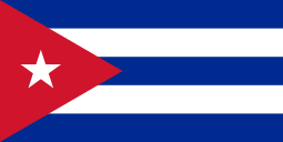 Regla, Cuba
 -
 Zhoushan, Zhejiang, People's Republic of China
See also
- East Richmond Heights
- El Sobrante
- Harry Ells High School
- North Richmond
- Point Richmond
- Rosie the Riveter/World War II Home Front National Historical Park
- USS Tacoma (PF-3)
References
- ↑ "California Cities by Incorporation Date" (Word). California Association of Local Agency Formation Commissions. Retrieved March 26, 2013.
- ↑ "Government". Richmond, California. Retrieved March 18, 2015.
- ↑ "City Council". Richmond, California. Retrieved January 28, 2015.
- ↑ "Senators". State of California. Retrieved March 27, 2013.
- ↑ "Members Assembly". State of California. Retrieved March 27, 2013.
- ↑ "California's 11th Congressional District - Representatives & District Map". Civic Impulse, LLC. Retrieved March 27, 2013.
- ↑ "2010 Census U.S. Gazetteer Files – Places – California". United States Census Bureau.
- 1 2 3 4 "Richmond". Geographic Names Information System. United States Geological Survey. Retrieved May 10, 2014.
- ↑ "Richmond (city) QuickFacts". United States Census Bureau. Retrieved March 24, 2015.
- ↑ "American FactFinder - Results". United States Census Bureau. Retrieved May 24, 2015.
- ↑ "American FactFinder - Results". United States Census Bureau. Retrieved April 16, 2015.
- ↑ "City of Richmond". Geographic Names Information System. United States Geological Survey. Retrieved May 10, 2014.
- 1 2 "FIPS55 Data: California". FIPS55 Data. United States Geological Survey. February 23, 2006. Archived from the original on June 18, 2006. Retrieved May 10, 2014. External link in
|work=(help) - ↑ East Shore and Suburban Railway Chronology, El Cerrito Historical Society, June 2007. Retrieved August 15, 2007.
- ↑ Johnson, Jason B. (January 10, 2007). "Green Party mayor takes the reins". San Francisco Chronicle.
- 1 2 "History of Richmond". City of Richmond. Retrieved June 25, 2007.
- 1 2 Durham, David L. (1998). California's Geographic Names: A Gazetteer of Historic and Modern Names of the State. Clovis, Calif.: Word Dancer Press. p. 689. ISBN 1-884995-14-4.
- ↑ Perrigan, Dana (June 29, 2008). "Where we live. Steeped in history, Richmond looks forward". San Francisco Chronicle. SFGate. Retrieved December 11, 2011.
Richmond was home to the world's largest winery, called Winehaven, until the federal government enacted Prohibition in 1919.
- ↑ Said, Carolyn (November 14, 2010). "Ford Point bringing new life to Richmond". Retrieved May 28, 2013.
- ↑ "Richmond's Historic Ford Point Building Craneway, ''Bay Crossings'', November 2007" (PDF). Retrieved February 19, 2013.
- ↑ "Rosie the Riveter – World War II Home Front National Historical Park: World War II in the San Francisco Bay Area". National Park Service. Retrieved June 26, 2007.
- ↑ Hendricks, Rickey. A Model for National Health Care: The History of Kaiser Permanente (New Brunswick, NJ: Rutgers University Press, 1993), 40–47, 63.
- ↑ "Going Wiggy over Wig-Wags – Pt. Richmond's Wig-Wag Controversy," by Jim Mallory, BayCrossings.com, July 6, 2002. Retrieved May 18, 2007.
- ↑ "Pullman Shop official website". Pullmanshops.com. Retrieved February 19, 2013.
- ↑ Hughes, Lyn. "A. Philip Randolph Pullman Porter Museum official website". Aphiliprandolphmuseum.com. Retrieved February 19, 2013.
- ↑ "Pullman & the African-American Experience". The Pullman State Historic Site. Retrieved May 28, 2013.
- ↑ Son of King shining light on poor, by John Geluardi, Contra Costa Times, May 1, 2007. Retrieved May 25, 2007.
- ↑ TTCA Welcomes the City of Richmond Into the California Main Street Program., Business Wire, December 13, 2007. Retrieved May 24, 2007.
- 1 2 3 4 5 6 7 8 9 10 Statistics of Richmond, California, City Data.com
- 1 2 3 City of Richmond Geographic Information System Viewer. Retrieved August 1, 2007.
- 1 2 3 Average Weather for Richmond, California, Weather.com.
- ↑ Bay Area EcoAtlas. Retrieved June 19, 2007 Archived February 13, 2009, at the Wayback Machine.
- ↑ "NowData – NOAA Online Weather Data". National Oceanic and Atmospheric Administration. Retrieved March 3, 2012.
- ↑ EBRPD, Point Isabel. Retrieved July 25, 2007.
- ↑ Born to be wild: Local trout goes global, San Francisco Chronicle, by Rick DelVecchio, April 22, 2005. Retrieved May 24, 2007.
- ↑ Spawners, Our Watershed. Retrieved July 26, 2007.
- ↑ Young whale washes up in East Bay, May 25, 2007, San Francisco Chronicle
- ↑ Beached whale's carcass to be towed to sea for burial. Retrieved June 7, 2007. Archived September 29, 2007, at the Wayback Machine.
- ↑ CoCo County Pays $18K To Remove Whale Carcass. Retrieved June 7, 2007.
- ↑ Burial at sea for hulkRed tape delayed earlier disposition of rotting remains. Retrieved June 7, 2007.
- ↑ Save The Bay's "Creeks to the Bay" Restoration Vision for Eastshore State Park, well.com. Retrieved August 1, 2007.
- ↑ Sewage Leaks, Richmond Councilman Tom Butt can't keep his mouth shut, bless him. Wikipedians poke at Dick Pombo's bio; and mystery fliers sully mayor's race, by Will Harper, East Bay Express, March 1, 2006. Retrieved August 1, 2007.
- ↑ A Step Toward "Cleaning and Greening" Richmond, MSH Properties' Richmond Cooperative Advances City's 5-Megawatt Solar Energy Goal, Borrego Solar, May 3, 2007. Retrieved August 2, 2007.
- ↑ 4 on council call for a state of emergency, by Jim Herron Zamora, Sfgate.com, San Francisco Chronicle, June 17, 2005. Retrieved May 24, 2007.
- ↑ "Office of Neighborhood Safety". Richmond, CA - Official Website. Retrieved June 21, 2014.
- ↑ Murphy, Tim (August 2014). "Did This City Bring Down Its Murder Rate by Paying People Not to Kill?". Mother Jones. Retrieved June 21, 2014.
- ↑ Jason Motlagh (Director) (June 6, 2014). "A city that pays criminals to behave". America Tonight. Al Jazeera America. Retrieved June 21, 2014.
- ↑ The Iron Triangle: Richmond's Forgotten Neighborhood, North Gate News Online. Archived June 10, 2007, at the Wayback Machine.
- ↑ Romney, Lee (May 2, 2015). "Homicide rates drop as Richmond chief builds bond with community". Los Angeles Times.
- ↑ Chevron Fined Over March Blast, Fire, Sfgate.com, San Francisco Chronicle, September 17, 1999.
- ↑ Taking the Toxic Tour, Commongroundmag.com, Common Ground Magazine, February 2005.
- ↑ Oil Spill Information, City of Richmond website. Retrieved December 18, 2007.
- ↑ Richmond Sinkhole Fix Could Cost $7.5 Million, CBS Local News, April 28, 2010. Retrieved August 12, 2010.
- ↑ http://www.ci.richmond.ca.us/index.aspx?nid=2628
- ↑ Malfunction Causes Emergency Warning Siren to Go Off in Richmond. KRON News. 2011-04-12. Retrieved 2011-04-12.
- ↑ "Annual Estimates of the Resident Population for Incorporated Places: April 1, 2010 to July 1, 2015". Retrieved July 2, 2016.
- ↑ "Census of Population and Housing". Census.gov. Archived from the original on May 11, 2015. Retrieved June 4, 2015.
- ↑ "2010 Census Interactive Population Search: CA - Richmond city". U.S. Census Bureau. Retrieved July 12, 2014.
- ↑ "Richmond's African-American population declining". Bay Area News Group at East Bay Times. 2015-05-22. Retrieved 2016-09-30.
- ↑ "Demographic Profile Bay Area Census".
- ↑ "American FactFinder". United States Census Bureau. Archived from the original on September 11, 2013. Retrieved January 31, 2008.
- 1 2 Richmond Fact Sheet, U.S. Census Bureau.
- ↑ Richmond, California entry, MLA Data Center. Retrieved October 21, 2007.
- ↑ "City of Richmond 2012CAFR". Retrieved May 20, 2013.
- ↑ Vetrazzo About Archived May 4, 2011, at the Wayback Machine.
- ↑ 23rd Street Corridor Visioning and Form-Based Code: Charette Summary Report Richmond, California. City of Richmond website. 2009-08-26. Retrieved 2011-05-22.
- ↑ "Macdonald 80 Shopping Center: Draft Initial Study/Mitigated Negative Declaration" (PDF). Pacific Municipal Consultants. June 2004.
- ↑ New Kohl's store proposed for Richmond, by Katherine Tam, Contra Costa Times, May 30, 2008. Retrieved August 8, 2008.
- ↑ Said, Carolyn (September 11, 2013). "Richmond to move forward with eminent domain plan". blog.sfgate.com. Retrieved September 11, 2013.
Richmond's City Council voted 4-3 early Wednesday morning to continue exploring the use of eminent domain for underwater mortgages [...]
- 1 2 Rogers, Robert (September 7, 2013). "Both sides in Richmond eminent domain plan set for showdown at City Council meeting". Contra Costa Times. Retrieved September 11, 2013.
Any vote to seize assets through eminent domain requires a supermajority of the council, per state law, meaning that five of Richmond's seven council members would need to agree.
- 1 2 "Calif. city moves ahead with eminent domain plan". Anchorage Daily News. Associated Press. September 11, 2013. Retrieved September 11, 2013.
- ↑ MacDuff, Cassie (September 6, 2013). "MORTGAGES: Eminent domain plan didn't fly in Inland area". Press-Enterprise blog. Retrieved September 11, 2013.
- ↑ Joffe, Marc (September 5, 2013). "Richmond, CA's Eminent Domain Mortgage Scheme Could Set An Ugly National Precedent". Forbes. Retrieved September 11, 2013.
- ↑ Palomino, Joaquin (September 10, 2013). "Realtors and residents debate Richmond&'s eminent domain plan". Richmond Confidential.
- ↑ "Richmond Reconsidering Eminent Domain Plan For Underwater Homeowners". cbslocal.com. CBS San Francisco and Bay City News Service. September 10, 2013. Retrieved September 11, 2013.
- ↑ "Fair Housing Groups Ask Court to Deny Banks' Effort to Stop Richmond's Mortgage Rescue Plan". RealEstateRama. September 10, 2013. Retrieved September 11, 2013.
- ↑ Hopkins, Megan (September 10, 2013). "City council to vote on Richmond eminent domain proposal". HousingWire. Retrieved September 11, 2013.
- ↑ Neighbors at odds over casino plan Proposal pits poor community against new subdivision. Cecilia Vega. San Francisco Chronicle. 2011-10-14. Retrieved 2011-01-21.
- ↑ Time Bomb Or Treasure, Sfgate.com, San Francisco Chronicle, April 9, 2001.
- 1 2 3 4 5 6 7 8 Richmond rejects tribe's plans for casino resort. Carolyn Jones. San Francisco Chronicle. 2011-04-07. Retrieved 2011-04-07.
- ↑ "Richmond Government". City of Richmond. Retrieved June 27, 2007.
- ↑ Jones, Carolyn (January 11, 2012). "George Livingston, Richmond's 1st black elected mayor". San Francisco Chronicle. Retrieved January 20, 2012.
- ↑ "Negro Councilman Elevated to Richmond Mayor's Post", Oakland Tribune, July 7, 1964, p19.
- ↑ Hallissy, Erin (December 13, 1999). "'TeflonDon' Faces FBI Probe in Richmond". San Francisco Chronicle. Retrieved 19 February 2015.
- ↑ The City of Richmond, California, Implements Enterprise Framework, ESRI
- ↑ Grand Prize-Winning "Extreme Makeover" Website Is Unveiled!, CivicPlus, January 5, 2007. Retrieved June 24, 2007.
- ↑ Council shifts way it fills seats, Contra Costa Times, by Joshua Geluardi, March 11, 2007. Retrieved May 25, 2007.
- ↑ Johnson, Chip. "California city questions Chevron's refinery upgrade". San Francisco Chronicle.
- ↑ OFFICIAL RESULTS OF THE 2006 MUNICIPAL ELECTION HELD ON NOVEMBER 7, 2006. Retrieved August 2, 2007.
- 1 2 3 Weber, Alex (July 22, 2010). "Will Richmond close its pot clubs before its new law goes into effect?". East Bay Express.
- ↑ Civic Center Revitalization, Mitigative and negative declaration, City of Richmond website. Retrieved August 1, 2007.
- ↑ "Operation Safe Homes". The U.S. Conference of Mayors. Retrieved June 27, 2007.
- ↑ Richmond wastewater treatment plant to resume operations amid controversy. San Francisco Chronicle. Retrieved 2011-01-28.
- ↑ Richmond students protest Exit Exam results, Oroville Mercury Register, June 7, 2007. Retrieved 2007-06-07.
- ↑ Contra Costa, Calif., School District Bans Soda, Junk Food, by Kara Shire, Contra Costa Times, August 30, 2003. Retrieved May 24, 2007.
- 1 2 3 4 5 6 City Council moves forward with soda tax, Alexis Kenyon, Richmond Confidential, 2011-12-12. Retrieved 2011-12-25
- ↑ National Park Service (2010-07-09). "National Register Information System". National Register of Historic Places. National Park Service.
- ↑ "Current Exhibitions - Richmond Art Center". Therac.org. September 18, 1980. Retrieved February 19, 2013.
- ↑ Hip-Hop Car Stunt Leaves 2 De, Associated Press, by Garance Burke, December 29, 2006. Retrieved August 12, 2007.
- ↑ Chris Treadway: Richmond temple plans Holocaust remembrance event, Chris Treadway, Contra Costa Times, 2012-04-16. Retrieved 2012-04-19
- ↑ "Miller/Knox Regional Shoreline | East Bay Regional Parks". Ebparks.org. Retrieved February 19, 2013.
- ↑ Point Isabel Shoreline the largest off-leash dog park in the nation, by Glen Martin, San Francisco Chronicle, August 16, 2004. Retrieved July 25, 2007.
- 1 2 3 Thousands Celebrate Cinco de Mayo in Richmond. Kornelia Trytko. Richmond Confidential. 2011-05-02. Retrieved 2011-05-07.
- ↑ "Richmond United in Silly Parade". Richmondconfidential.org. April 4, 2011. Retrieved February 19, 2013.
- ↑ Earth Day Celebrations Being Richmond Together. Richmond Confidential.
- ↑ Physical Activity and Nurtrition Forum Flyer 2011. 2011.
- ↑ Pow-Wow in Richmond honors Native American culture, Spencer Whitney, Richmond Confidential, 2012-06-25. Retrieved 2012-07-03
- ↑ "Feature Detail Report for: KNEW-AM (Oakland)". Geographic Names Information System. United States Geological Survey. Retrieved August 10, 2008.
- 1 2 "Richmond, CA – Official Website – Port Operations". City of Richmond. Retrieved June 26, 2007.
- ↑ "Bay Area Freeway Congestion Up for Third Straight Year in 2006". Metropolitan Transportation Commission. June 18, 2007.
- ↑ Amtrak.com, Capitol Corridor, Stations (map). Retrieved July 5, 2007.
- ↑ keysystemmap.gif, BayRails. Retrieved August 13, 2007.
- ↑ New Date: Upcoming Service Changes, AC Transit Marketing, March 15, 2007. Retrieved June 7, 2007.
- ↑ AC Transit Service Changes. Retrieved June 7, 2007 Archived May 24, 2007, at the Wayback Machine.
- ↑ West County Service Plan Community and Drivers Input (PDFs). Retrieved June 7, 2007.
- ↑ West Contra Costa County Service Plan (PDFs). Retrieved June 7, 2007.
- ↑ WestCat System Map, WestCat.org. Retrieved June 26, 2007.
- ↑ RFS schedule, Bear Transit website
- ↑ "MTC – News – Transactions". Mtc.ca.gov. September 7, 2010. Retrieved February 19, 2013.
- ↑ Richmond Ferry to Sail, San Francisco Chronicle.
- ↑ Richmond Ferry Wins Praise But Few Riders, San Francisco Chronicle.
- ↑ Water Transit Authority Archived September 28, 2007, at the Wayback Machine.
- ↑ "Berkeley Daily Planet – Friday June 03, 2005". Berkeleydailyplanet.com. Retrieved February 19, 2013.
- ↑ 2007 State of the City Address, by Gayle McLaughlin, March 6, 2007, Gayle McGlaughlin website. Retrieved August 3, 2007.
- ↑ "Richmond Fire Department". Ci.richmond.ca.us. Retrieved February 19, 2013.
- ↑ "Public Safety Police Department". Retrieved February 19, 2013.
- ↑ Regional News, California Track and Running News
- ↑ Raiders.com, Courtney Anderson profile. Retrieved June 23, 2007.
- ↑ NFL.com, 2007 Draft: Prospect Profiles, Courtney Anderson. Retrieved June 23, 2007.
- ↑ http://bassfederation.com/news/mark-daniels-jr-and-ben-wright-crowned-2013-federation-national-champions-on-oklahomas-grand-lake-o-the-cherokees/;
- ↑ http://www.flwoutdoors.com/ap/bio.cfm?mid=282298;
- ↑ http://www.blacksportsthemagazine.com/Magazines/June13.pdf
- ↑ Coach Carter movie official website, CoachCarter.com. Retrieved May 17, 2007.
- ↑ baseball-reference.com, Ricky Jordan profile. Retrieved July 2, 2007.
- ↑ Willie McGee Goes to Bat for Students, by Jason B. Johnson, reprinted with the permission of the San Francisco Chronicle, January 29, 2005. Retrieved January 29, 2009.
- ↑ Master P#Basketball career
- ↑ Baseball Reference profile of Dave Smith, Baseball-reference.com. Retrieved May 17, 2007.
- ↑ Database Football profile of Lamont Thompson, Databasefootball.com. Retrieved May 17, 2007.
- ↑ U.S. Soccer Referees Work More Than 400 Professional & International Games in July..., August 6, 2004. Retrieved August 8, 2008.
- ↑ Rock on: Richmond world-renowned guitarist has lived more than two decades with ALS, Matthias Gafni, Contra Costa Times, 2012-03-23. Retrieved 2012-03-26
- ↑ KochEntertainment.com profile of Master P, KochEntertainment.com . Retrieved May 17, 2007.
- ↑ Lucretia Edwards Shoreline Park, City of Richmond. Retrieved May 17, 2007.
- ↑ Open Space Advocate Honored With a Park, by John Geluardi, Berkeley Daily Planet, January 2, 2004. Retrieved May 17, 2007.
- ↑ Rogers, Roberts (September 8, 2011). "Fred Jackson, North Richmond leader, dead at 73". Richmond Confidential. Retrieved February 24, 2012.
- ↑ Secrets of living a long life, by Chip Johnson, San Francisco Chronicle, May 1, 2001. Retrieved June 17, 2007.
- ↑ http://journalism.berkeley.edu/projects/juvenile/structure/soto.html
- ↑ http://www.abc15.com/dpp/about_us/staff/pete-suratos
Bibliography
- "Feature Detail Report for: Richmond". Geographic Names Information System. United States Geological Survey.
External links
| Wikimedia Commons has media related to Richmond, California. |
- Official website
- West Contra Costa Unified School District
- USGS Faultline interactive for Richmond and East Bay
-
 "Richmond, a city of California". Collier's New Encyclopedia. 1921.
 |
San Pablo Bay | Tara Hills | El Sobrante | |
| San Rafael | |
East Richmond Heights | ||
| ||||
| | ||||
| San Francisco Bay | Albany | El Cerrito |
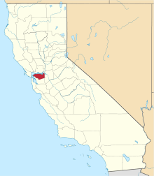
| Bodies of water |
|  |
|---|---|---|
| Counties | ||
| Major cities | ||
| Cities and towns 100k–250k | ||
| Cities and towns 50k–99k | ||
| Cities and towns 25k-50k | ||
| Cities and towns 10k–25k |
| |
| Sub-regions | ||
| |
^* Mayor selected from city council
|