Santa Clara River Valley

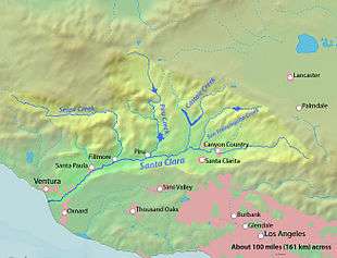

The Santa Clara River Valley is a valley in Ventura County, California that has been given the moniker Heritage Valley by the namesake tourism bureau.[1] The valley includes the communities of Santa Paula, Fillmore, Piru and the national historic landmark of Rancho Camulos. Named for the Santa Clara River,[2] which winds through the valley before emptying into the Pacific Ocean between the cities of Ventura and Oxnard, the tourist bureau describes it as ".... Southern California's last pristine agricultural valley nestled along the banks of the free-flowing Santa Clara River."[3]
Geography
The Santa Clara River Valley is bordered by the Topatopa Mountains, Los Padres National Forest, and Sespe Condor Sanctuary to the north and the Santa Susana Mountains to the south. The valley stretches from the boundary of northwest Los Angeles County and the northern Santa Clarita Valley on the east to the Oxnard Plain on the west marked by South Mountain[4] on the south bank of the river. The Santa Clarita Valley is part of the upper watershed of the river.
History
A footpath through the valley was the only route linking the San Fernando and San Buenaventura missions for 18th-century Spanish priests. Thomas Bard launched a campaign in the 1870s to build a road through the valley as he wanted to connect the new Hueneme wharf with ore mines in Inyo County[5]
The valley is an exception to the post-war urban development that has almost entirely eradicated the evidence of citrus cultivation throughout most of Southern California.
Roads & Highways
- Route 126 - the main E-W highway serving the valley.
- Route 150 - a minor N-S highway connecting Ojai to the valley.
- Route 23 - a minor N-S highway connecting Fillmore to the Conejo Valley.
References
- ↑ Kelly, Peggy (October 15, 1999) "Funding for Montalvo Metrolink station would benefit SP Branch Line" Santa Paula Times
- ↑ U.S. Geological Survey Geographic Names Information System: Santa Clara River
- ↑ Heritage Valley Tourism Bureau official website
- ↑ U.S. Geological Survey Geographic Names Information System: South Mountain
- ↑ Lima, Christina (February 18, 1996) "Collision Course : Scenic but Dangerous California 126 Throws Drivers a Curve" Los Angeles Times
External links
| Wikimedia Commons has media related to Santa Clara River (California). |
- USGS.gov: The Santa Clara River Valley
- County of Ventura.gov: Santa Clara River Watershed]
- Santa Clara River Watershed Committee (SCRWC) website
Municipalities and communities of Ventura County, California, United States | ||
|---|---|---|
| Cities | 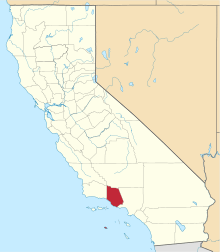 | |
| CDPs | ||
| Unincorporated communities | ||
| Footnotes | ‡This populated place also has portions in an adjacent county or counties | |

Municipalities and communities of Ventura County, California, United States | ||
|---|---|---|
| Cities | | |
| CDPs | ||
| Unincorporated communities | ||
| Footnotes | ‡This populated place also has portions in an adjacent county or counties | |
Coordinates: 34°22′0″N 118°59′0″W / 34.36667°N 118.98333°W