Fremont, California
| Fremont, California | ||
|---|---|---|
| City | ||
| City of Fremont | ||
|
A view of Mission Peak from Fremont Central Park in 2006. | ||
| ||
 Location of Fremont within Alameda County, California | ||
 Fremont, California  Fremont, California  Fremont, California Location of Fremont within Alameda County, California | ||
| Coordinates: 37°32′54″N 121°59′19″W / 37.54833°N 121.98861°WCoordinates: 37°32′54″N 121°59′19″W / 37.54833°N 121.98861°W | ||
| Country |
| |
| State |
| |
| County |
| |
| Incorporated | January 23, 1956[1] | |
| Named for | John Charles Frémont | |
| Government | ||
| • Type | Council–manager[2] | |
| • City council[3] |
Mayor Bill Harrison Vice Mayor Suzanne Lee Chan Vinnie Bacon Lily Mei Rick Jones | |
| • City manager | Fred Diaz[4] | |
| • State senator | Bob Wieckowski (D)[5] | |
| • Assemblymembers | Bill Quirk (D) and Kansen Chu (D)[6] | |
| • United States representatives | Eric Swalwell (D) and Mike Honda (D)[7] | |
| Area[8] | ||
| • Total | 87.6 sq mi (226.9 km2) | |
| • Land | 77.5 sq mi (200.6 km2) | |
| • Water | 10.2 sq mi (26.3 km2) 11.6% | |
| Elevation[9] | 56 ft (17 m) | |
| Population (2014)[10] | ||
| • Total | 220,000 | |
| • Estimate (2016) | 232,206 | |
| • Rank |
2nd in Alameda County 16th in California 96th in the United States | |
| • Density | 2,500/sq mi (970/km2) | |
| Time zone | Pacific (UTC−8) | |
| • Summer (DST) | PDT (UTC−7) | |
| ZIP codes[11] | 94536–94539, 94555 | |
| Area code | 510 | |
| FIPS code | 06-26000 | |
| GNIS feature IDs | 277521, 2410545 | |
| Website |
www | |


Fremont /ˈfriːmɒnt/ is a city in Alameda County, California, western United States. It was incorporated on January 23, 1956, from the merger of five smaller communities: Centerville, Niles, Irvington, Mission San Jose, and Warm Springs. The city is named after American explorer John Charles Frémont.
Located in the southeast section of the San Francisco Bay Area in the East Bay region primarily, Fremont has a population of around 230,000.[10] It is the fourth most populous city in the San Francisco Bay Area, and the largest suburb in the metropolis. It is the closest East Bay city to Silicon Valley, and is thus sometimes associated with it.
The area consisting of Fremont, Newark (an enclave of Fremont), and Union City (formed from the communities of Alvarado and Decoto), is now known as the Tri-City Area.
Fremont is home to the largest population of Afghan Americans in the United States.[12]
History
Early history
The recorded history of the Fremont area began on June 6, 1795, when Mission San José was founded by the Spaniard Father Fermin de Lasuen. The Mission was established at the site of the Ohlone village of Oroysom. On their second day in the area, the Mission party killed a grizzly bear in Niles Canyon. The first English-speaking visitor to Fremont was the renowned trapper and explorer Jedediah Smith in 1827. The Mission prospered, eventually reaching a population of 1,887 inhabitants in 1831. The influence of the missionaries declined after 1834, when the Mexican government enacted secularization.
José de Jesus Vallejo, brother of Mariano Vallejo, was the grantee of the Rancho Arroyo de la Alameda Mexican land grant. His family was influential in the Fremont area in the late colonial era, and owned and built a flour mill at the mouth of Niles Canyon.[13] In 1846 they were visited by the town's namesake John C. Frémont, who mapped a trail through Mission Pass to provide access for American settlers into the southeastern San Francisco Bay Area.
The Fremont area grew rapidly at the time of the California Gold Rush. A town called Mission San Jose grew up around the old mission, with its own post office from 1850. Agriculture dominated the economy with grapes, nursery plants and olives as leading crops. In 1868 the 6.8-magnitude Hayward earthquake on the Hayward Fault collapsed buildings throughout the Fremont area, ruining Mission San José and its outbuildings. Until the 1906 San Francisco earthquake caused its destruction, the Fremont area's Palmdale Winery was the largest in California. The ruins of the Palmdale Winery are still visible near the Five Corners in Irvington.[14]
From 1912 to 1915 the Niles section of the Fremont area was the earliest home of California's motion picture industry.[15] (See Essanay Studios.) Charlie Chaplin filmed several movies in the Fremont area, most notably The Tramp.
Incorporation
Fremont was incorporated under the leadership of Wally Pond in 1956, when five towns in the area, Irvington, Centerville, Mission San Jose, Niles and Warm Springs came together to form a city.[16] Glenmoor Gardens is the largest subdivision in Fremont, was under construction in the area, by developers Ralph E. Cotter, Jr., James R. Meyer, civil engineer Fred T. Duvall, and contractors James L. Reeder, and Robert H. Reeder. When the Glenmoor Gardens Homeowners Association (GGHA) was incorporated, in March 1953, there were no more than 75 houses in the subdivision. It was probably the first such organization in the Fremont area; in its scope and structure. The five-member board of directors (which included James Meyer and James Reeder) was set up to oversee a full range of services, from police and fire protection to street maintenance (which later became the purview of the city government).[17]
Fremont became more industrialized between 1953 and 1962. A boom in high-tech employment in the 1980s to the late 1990s, especially in the Warm Springs District, caused rapid development in the city and linked the city with the Silicon Valley. The Apple factory where the first Mac computer was manufactured was located in Fremont[18] (production ceased in 1993).[18] Other semiconductor and telecommunications firms soon opened in the city, including Cirrus Logic, Asyst Technologies, Mattson Technology, Lam Research, Premisys Communications, and Nextlink California.[18] Approximately 750 high tech companies had offices, headquarters or production facilities in Fremont by 1999.[18] These firms included fifteen of the top one hundred fastest-growing public companies in the San Francisco Bay Area and eighteen of the top fifty companies in the East Bay.[18]

The General Motors automotive assembly plant in South Fremont was the town's largest employer, and Fremont was known for its drag strip. In the 1980s the GM plant became a joint venture automotive assembly plant of Toyota and General Motors called NUMMI. Toyota and NUMMI shut down its operations in early 2010. Part of the plant was acquired in June 2010 by Tesla Motors as its primary production plant, known as the Tesla Factory.
Solyndra, a solar panel manufacturer, was launched by the Bush administration in 2007 and promoted in 2010 by President Barack Obama as a model for government investment in green technology[19] after his administration approved a $535-million Department of Energy loan guarantee and the company built a $733 million state-of-the-art robotic facility, but in 2011 the company filed for Chapter 11 bankruptcy and laid-off 1,000 workers.[20] Data storage company Seagate Technology, incorporated in the Republic of Ireland with executive offices in Cupertino, acquired the former Solyndra building.
The first Fremont post office opened in 1956.[21]
Geography
Centerville, Niles, Irvington, Mission San Jose, and Warm Springs were the original five small independent towns that combined and incorporated to form Fremont in 1956. Today, these places have greatly expanded, are no longer separate communities, and are considered districts or community plan areas of the more or less developed city of Fremont. The town of Newark declined to join Fremont, and is now an enclave of it. Since incorporation, Fremont has created six more districts, which it calls "community plan areas" for planning purposes. These include Central, North Fremont, South Fremont, and Bayside. The two other districts, Baylands and the Hill Areas, are primarily open space.[22]
Centerville District
Centerville was perhaps the main town in Washington Township. Centerville is located at 37°33′15″N 121°59′57″W / 37.55417°N 121.99917°W. It lies at an elevation of 52 feet (16 m). Centerville was started by George Lloyd who started selling cold beer to stage passengers from a tent in 1850.[23] Capt. George Bond set up a general store and the name Centerville was chosen.[23] The post office opened Centreville post office in 1855 and changed the spelling to Centerville in 1893.[23] The Centerville Pioneer Cemetery contains the burial places of many of the city's founding pioneers.
Centerville can be traced back to its native American roots. Spanish, Mexican, Italian, Portuguese and Swiss (Swiss Park), peoples were among the early settlers that contributed greatly to the growth Centerville. Most of Centerville was and still is Catholic.
Early Centerville was a quiet farming community, which consisted of large Spanish land grants divided into smaller farms. The Freitas Ranch on Thornton Ave was probably the largest of the working farms. There were acres of Apricot along with other fruit and nut orchards and large fields of various types of fresh produce.[24]

| Wikimedia Commons has media related to Japanese American internment processing in Centerville, Alameda County, California. |
After President Roosevelt issued Executive Order 9066, which authorized military commanders to exclude "any or all persons" from certain areas in the name of national defense, the Western Defense Command began ordering Japanese Americans living on the West Coast to present themselves for "evacuation" from the newly created military zones. This included many Centerville farming families.
Centerville was also a main stop for the early railways. This gave the local farmers a way to quickly get their produce to market. With the access to railway service there was once a large cannery on Baine Ave. west of Fremont Ave. (now Peralta) next to the tracks. In 1959, the cannery was destroyed in the largest fire in Fremont's history.[25] The fire lasted for two days, and effectively put an end to what had been the largest employer in Centerville at the time. The cannery was never rebuilt.[26]
Prior to the end of WWII housing developments,in the area, were largely nonexistent. Most of the early housing stood along Fremont Blvd. from Decoto Road, south to Washington High school, along Thornton Ave. from Fremont Blvd., west to the Newark city border and along Peralta Blvd, from Fremont Blvd. to Niles.
For city planning purposes, Centerville was enlarged to encompass most of the north central residential section of Fremont, from Mowry Ave to Decoto Rd, from I-880 to the BART line. This Centerville community plan area includes the sprawling subdivisions, developed in the 1950s and 1960s, of Glenmoor Gardens, bounded by Central Avenue, Fremont Boulevard, Mowry Avenue, and the I-880 freeway. and the Cabrillo Park subdivision bound by, Thornton Ave, Fremont Blvd, Decoto Road and the I-880 freeway. Also the Brookvale subdivisions, the Quarry Lakes Regional Park, and part of Parkmont.[27] The area is served by two high schools, Washington High School (Fremont, California) established in 1892, which for a long time was the only high school in the area and American High School established in 1972. It also has two junior high schools, Centerville Junior High School and Thornton Junior High School, which now stands on the old main site of the Freitas ranch.
Niles District

The town is physically divided from other parts of Fremont and neighboring Union City by Mission Boulevard (State Route 238) to the east and north, Alameda Creek to the south, Union Pacific Railroad to the west and southeast, and the Quarry Lakes to the southwest. The hills of Niles are lower than those of the area south of the Alameda Creek in Mission San Jose. Old Town Niles features its own library, post office, and silent movie theater as well as a large number of antique and craft stores. The town is named after Addison Niles. Niles is located at 37°34′44″N 121°58′40″W / 37.57889°N 121.97778°W. It lies at an elevation of 112 feet (34 m).
Niles was the home of one of the first West Coast motion picture companies, Essanay Studios. Charlie Chaplin and Broncho Billy Anderson filmed some of their most famous silent movies in Niles. Scenic Niles Canyon stretches between Niles and Sunol. The nonprofit Niles Essanay Silent Film Museum offers both artifacts of Niles' early years, and each Saturday evening, screenings of early-twentieth-century silent films, many of which were filmed locally.
The Niles Canyon Railway runs along Alameda Creek, and carries passengers on weekend excursions, including a holiday 'train of lights' which is extremely popular – tickets for these trains typically sell out by early October. The Niles Canyon Railroad has a small but well-maintained collection of historic rail stock.
Of special note is the annual antique fair and flea market which takes place on the last Sunday in August. The entire town turns out with things to sell as early as Saturday morning, with bargain hunters from the Bay Area and beyond visiting in search of bargains. Niles is also home to the Fremont Gurdwara, which serves the large American Sikh community of Fremont as a religious shrine open to not only the Sikhs but to everyone regardless of their caste and religion.
The place was originally known as Vallejo's Mills for Vallejo Flour Mill built there.[28] Niles was named by the Central Pacific Railroad in 1869 for Judge Addison C. Niles, who later was elected to the California Supreme Court.[28] A post office was opened at Niles in 1873.[28]
Part of historic Niles is Mayhew Spring, also known as Mayhew's Sulphur Spring, which was located 600 feet (180 m) north of the Niles railroad depot.[28] The facility was owned by H.A. Meyhew.[28] The coast to coast completion of Transcontinental Railroad is reported to have occurred in nearby Niles Canyon. In September 1869, four months after the famous golden spike ceremony at Promontory Summit, Utah, the Central Pacific Railroad completed the transcontinental rail link between Sacramento and the San Francisco Bay, finishing the track through the canyon. The Central Pacific had acquired the Western Pacific and other local railroads and built track to connect them at a waterfront terminal at Alameda Point.
Also part of Niles is Niles Junction on the Western Pacific Railroad,[28] located at 37°34′35″N 121°58′17″W / 37.57639°N 121.97139°W, and situated at an elevation of 79 feet (24 m).
Irvington District
The Irvington District area has cycled through many name changes over time. Shortly after the US Civil war, a freed male black slave traveled from the southern United States to California, reputedly in search of a fortune. This former slave noticed the traffic at the crossroads of what is today the "Five Corners" intersection in Fremont; the transcontinental railroad passed through this region, bringing many passers-by. Realizing a financial opportunity, this freed slave constructed the first building at the cross roads, a tavern with an inn. For many years, due to a lack of a formal name, the intersection was known as "Nigger Corners".[29] This corner, today the intersection of Fremont and Washington Boulevards, Union and Bay Streets, is known as "Five Corners" or Irvington Square. Irvington Square's marker, Irvington Plaza park, is located at 37°31′22″N 121°58′18″W / 37.52278°N 121.97167°W. The inn and several of the other original buildings were demolished by the city of Fremont in the early 1980s.
In 1871 Washington College, one of the first industrial educational institutions in California, was established in Washington township near the crossroads. As a result, the US Postal Service established a post office called Washington Corners at the college in 1870, which became the name of the settlement on the 1878 Alameda County map of Washington Township.
In 1884, realizing the need for a proper town name, local inhabitants selected the name of Irving. The name was chosen in honor of Judge Irving, the local traveling circuit judge of the time. Later, when the railroad came through the area, the published train schedule pamphlets erroneously listed the Irving train depot as "Irvington." The town petitioned the railroad about the error. The railroad company notified the town that it was too costly for them to replace the train schedule pamphlets (over $100,000); and in 1887 following the recommendation, the people of Irving changed the town name to Irvington.
The Irvington district has two main neighborhoods: Irvington Woods and the Irvington Square. The neighborhood is ethnically mixed and is primarily working class. For city planning purposes, the Irvington area was enlarged to encompass most of the south central residential section of Fremont, from Auto Mall Parkway to Mowry Avenue, from I-880 to roughly the BART line (excluding the Central District described below). This Irvington community plan area includes the Sundale neighborhood, the South Sundale neighborhood, 28 Palms, Blacow, and Grimmer subdivisions. The area is served by three high schools: Irvington High School, Robertson High School, and John F. Kennedy High School.
Mission San Jose District
At the time of the California Gold Rush, a boom town grew up around the old Mission, to equip and transport 49ers overland to the gold fields. A post office was opened at Mission San Jose in 1850.[30]
The district, like Niles, is surrounded by hills. The hills are higher and steeper than Niles, with the highest points being on the Mission Ridge. Mission San Jose district lies close to the northern two peaks, Mission Peak and Mount Allison. Mission Peak is very distinctive and is one of Fremont's emblems. These peaks go from 2,517 to 2,604 ft (794 m), taller than Mount Tamalpais, a great height for the San Francisco Bay Area. They see some deep snow occasionally.
Fremont's community college, Ohlone College, is situated one block away from the mission and serves over 12,000 students.
Mission San Jose has the highest concentration of Asian Americans in Fremont – over 50% of the population as of the 2000 census. The local high school is Mission San Jose High School, it is ranked 67 in the nation by U.S. News & World Report. The median family income for the Mission San Jose area (ZIP code 94539) exceeded $114,595 in 2005. Owing to an influx of professionals and other affluent families seeking access to the top-performing local public schools, Mission San Jose's median home value reached $831,000 in 2006, earning the community a rank of 237 on Forbes magazine's list of the 500 most affluent communities in the United States.[31]
In 2001 an attempt by community organizations in the Mission San Jose district to withdraw from the Fremont Unified School District caused state-wide controversy and led to accusations of racism from both sides. The attempt was prompted by a re-drawing of the school enrollment areas, under which some Mission San Jose residents would send their children to Horner Junior High and Irvington High schools. The controversial effort to secede was dropped later that year. Fremont's public schools continue to rank among the best in California.[32][33]
Mission San Jose
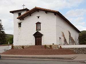
Nestled at the base of Fremont's rolling hills is the Mission San José, one of the oldest of the historic Spanish missions in California, for which this district is named. The church building that exists today is a re-construction (dedicated in 1985 for daily Mass and tours) of the original 1809 adobe church that was destroyed by the 1868 Hayward-fault earthquake. One side of the original mission quadrangle remains and houses a museum. Mission San Jose is located at 37°31′59″N 121°55′13″W / 37.53306°N 121.92028°W; and lies at an elevation of 305 feet (93 m).
Warm Springs District
Warm Springs is located on Rancho Agua Caliente and is so named for the springs that are located there.[34] In early times, there was a settlement called Harrisburgh (also, Harrisburg and Peacock's) a short distance east from the small settlement of Warm Springs.[34] A post office opened in Harrisburgh in 1865 and changed its name to Warm Springs in 1885.[34] The name Harrisburgh commemorated Abram Harris, who settled there in 1858.[34] The name Peacock's commemorated George W. Peacock, its first postmaster.[34] The post office name changed to Warmsprings in 1895 and reverted to Warm Springs in 1950.[34]
The Warm Springs district is the southernmost portion of Fremont whose hub is the Warm Springs and Mission Boulevard intersection. It is located at 37°29′14″N 121°55′45″W / 37.48722°N 121.92917°W, and lies at an elevation of 62 feet (19 m). Due to its proximity to the center of Silicon Valley, Warm Springs has attracted the headquarters of many high-tech companies including Nielsen Norman Group, Lam Research, Corsair Memory and Lexar of the US as well as foreign high-tech companies such as Elitegroup Computer Systems, and Asus. The district is also home to blue-collar industry. The San Jose mission is also present.
Warm Springs also serves as commercial center for the mainly residential Mission San Jose district, especially since the construction of Pacific Commons, a large, modern regional shopping center. The Oakland Athletics talked about moving their stadium to this area. The large Asian population in Mission San Jose comes to Warm Springs for authentic Asian stores such as the 99 Ranch & Marina Food supermarkets, as well as more traditional supermarkets such as Safeway. It was also home to one of the SF Bay Area's only two coffee houses to employ baristas who wear bikinis, Your Coffee Cups, a concept that's gained some controversy from Bay Area newspapers and news stations.[35][36][37][38] This controversy led to the eventual closing of the business.
The BART extension to Warm Springs has been under construction since 2009.[39]
Central district

The central district is surrounded by the Centerville, Niles, Mission San Jose, and Irvington communities. The central district contains retail shopping centers (e.g., the Fremont Hub), the Fremont Bay Area Rapid Transit station, health care centers and Central Park (Lake Elizabeth).
City planners envision a mid-density, pedestrian friendly, transit oriented development, bounded by Mowry Ave, Fremont Blvd, Walnut Ave, and Paseo Padre Pkwy.[22][40] One of the central streets, the Capital Avenue extension to Fremont Blvd, was completed in 2016, as the city pursues its plans for a Downtown Fremont.
North Fremont District

North Fremont is a primarily residential district surrounded by Union City, Centerville District, Newark, and Coyote Hills Regional Park. It is a growing community that includes the Ardenwood neighborhood, the Lakes and Birds neighborhood, and the Northgate neighborhood.[41] It is the site of the Ardenwood Historic Farm, which has the George Washington Patterson House as one of its highlights, and the Ardenwood Technology Park. A 99 Ranch Market is one of many Asian businesses in the North Fremont District. Thornton Junior High School and American High School, which are both physically located in the enlarged Centerville District, also serve as the junior high and high school, respectively, for this community.
South Fremont District
South Fremont is a primarily industrial district, east of Interstate 880 and west of Interstate 680, south of Auto Mall Parkway and north of Brown Rd. The area overlaps with Warm Springs, with which it shares the eponymous BART station. The composition of the area will change, because thousands of residential units were under construction as of 2016. It is sandwiched between the Irvington and Warm Springs community plan areas.[22][40] It is noted as the site of the Tesla Factory as well as the site of the future Warm Springs / South Fremont BART station.
Bayside Industrial District
Bayside Industrial is a primarily industrial and commercial district, west of Interstate 880 between Newark and Milpitas.[22][40]
Baylands District
Baylands is an open space (bay and land) district that stretches from the Bay and engulfs the western edge of North Fremont, Newark, and Bayside Industrial.[22][40] It is the site of the headquarters and visitor center of the Don Edwards San Francisco Bay National Wildlife Refuge.
Hill Area District
Hill Area is an open land district that forms the eastern edge of Fremont.[22][40] It is the site of Mission Peak.
Climate
Fremont has a Mediterranean climate, typical of the San Francisco Bay Area. Like nearby San Jose, precipitation is fairly low (under 15 inches per year) because the city lies in the rain shadow of the Santa Cruz Mountains to the west.
| Climate data for Fremont, California | |||||||||||||
|---|---|---|---|---|---|---|---|---|---|---|---|---|---|
| Month | Jan | Feb | Mar | Apr | May | Jun | Jul | Aug | Sep | Oct | Nov | Dec | Year |
| Average high °F (°C) | 58.1 (14.5) |
61.6 (16.4) |
65.3 (18.5) |
69.0 (20.6) |
71.9 (22.2) |
75.4 (24.1) |
78.1 (25.6) |
79.0 (26.1) |
78.3 (25.7) |
72.8 (22.7) |
64.4 (18) |
57.8 (14.3) |
69.31 (20.73) |
| Average low °F (°C) | 42.2 (5.7) |
44.3 (6.8) |
46.3 (7.9) |
48.5 (9.2) |
51.6 (10.9) |
54.8 (12.7) |
56.6 (13.7) |
56.8 (13.8) |
55.5 (13.1) |
51.7 (10.9) |
46.1 (7.8) |
42.5 (5.8) |
49.74 (9.86) |
| Average precipitation inches (mm) | 3.07 (78) |
3.17 (80.5) |
2.92 (74.2) |
1.16 (29.5) |
0.49 (12.4) |
0.10 (2.5) |
0.00 (0) |
0.04 (1) |
0.21 (5.3) |
0.85 (21.6) |
1.85 (47) |
2.82 (71.6) |
16.68 (423.6) |
| Source: NOAA[42] | |||||||||||||
Demographics
| Historical population | |||
|---|---|---|---|
| Census | Pop. | %± | |
| 1960 | 43,790 | — | |
| 1970 | 100,869 | 130.3% | |
| 1980 | 131,945 | 30.8% | |
| 1990 | 173,339 | 31.4% | |
| 2000 | 203,413 | 17.3% | |
| 2010 | 214,089 | 5.2% | |
| Est. 2015 | 232,206 | [43] | 8.5% |
According to a 2007 estimate, the median income for a household in the city is $93,342, and the median income for a family was $103,846.[45] Males have a median household income of $59,274 versus $40,625 for females. The per capita income for the city was $31,411. About 3.6% of families and 5.4% of the population were below the poverty line, including 5.9% of those under age 18 and 6.2% of those age 65 or over.
Politically, Fremont leans towards[46] the Democratic Party.
As of 2010 more than half the residents of Fremont were of Asian ancestry, with large populations of Chinese, Asian Indians, and Filipinos.
2010
The 2010 United States Census[47] reported that Fremont had a population of 214,089. The population density was 2,443.7 people per square mile (943.5/km²).
The racial makeup of Fremont was:
108,332 (50.6%) Asian (consisting of 18.1% Indian, 17.8% Chinese, 6.7% Filipino, 2.5% Vietnamese, 1.8% Korean, 1.0% Pakistani, 0.8% Japanese, 0.6% Burmese)
70,320 (32.8%) White, (the town is home to the largest population of Afghan Americans in the United States, who are included in both Asian and White categories. Non-Hispanic Whites were 26.5% of the population in 2010,[48] down from 85.4% in 1970.[49])
31,698 (14.8%) Hispanic or Latino of any race. (consisting of 11.0% Mexican, 0.6% Puerto Rican, 0.5% Salvadoran).
13,605 (6.4%) from other races,
12,584 (5.9%) from two or more races
7,103 (3.3%) African American,
1,169 (0.5%) Pacific Islander,
976 (0.5%) Native American,
The Census reported that 212,438 people (99.2% of the population) lived in households, 969 (0.5%) lived in non-institutionalized group quarters, and 682 (0.3%) were institutionalized.
There were 71,004 households, out of which 31,070 (43.8%) had children under the age of 18 living in them, 45,121 (63.5%) were opposite-sex married couples living together, 7,070 (10.0%) had a female householder with no husband present, 3,382 (4.8%) had a male householder with no wife present. There were 2,779 (3.9%) unmarried opposite-sex partnerships, and 444 (0.6%) same-sex married couples or partnerships. 11,576 households (16.3%) were made up of individuals and 3,697 (5.2%) had someone living alone who was 65 years of age or older. The average household size was 2.99. There were 55,573 families (78.3% of all households); the average family size was 3.36.
The population was spread out with 53,216 people (24.9%) under the age of 18, 15,610 people (7.3%) aged 18 to 24, 66,944 people (31.3%) aged 25 to 44, 56,510 people (26.4%) aged 45 to 64, and 21,809 people (10.2%) who were 65 years of age or older. The median age was 36.8 years. For every 100 females there were 98.9 males. For every 100 females age 18 and over, there were 96.4 males.
There were 73,989 housing units at an average density of 844.5 per square mile (326.1/km²), of which 44,463 (62.6%) were owner-occupied, and 26,541 (37.4%) were occupied by renters. The homeowner vacancy rate was 1.3%; the rental vacancy rate was 4.5%. 136,606 people (63.8% of the population) lived in owner-occupied housing units and 75,832 people (35.4%) lived in rental housing units.
|
2000s
Thanks in large part to a substantial influx of Afghans granted asylum in the United States following the 1979 invasion of Afghanistan by the Soviet Union, Fremont is the home to the largest concentration of Afghan Americans in the United States.[12] This is noted in Khaled Hosseini's 2003 novel Kite Runner. In addition, Fremont has a notable concentration of Asian Indians, predominantly employed in Silicon Valley's technology sector.
Among the Asian community of Fremont, the largest ethnic groups are Chinese, Indians, and Filipinos. Fremont and nearby Union City have fairly large numbers of Pacific Islanders, Cubans and Puerto Ricans, Spanish and Portuguese, and a small number of American Indians.
Fremont also has a large Deaf community, in large part because it is home of the Northern California campus of the California School for the Deaf. The school district is called the Fremont Unified School District which also serves parts of Union City and Hayward.
There were 68,237 households out of which 40.2% had children under the age of 18 living with them, 62.7% were married couples living together, 9.2% had a female householder with no husband present, and 23.5% were non-families. 16.5% of all households were made up of individuals and 4.1% had someone living alone who was 65 years of age or older. The average household size was 2.96 and the average family size was 3.34.
In the city the population was spread out with 25.8% under the age of 18, 7.7% from 18 to 24, 36.8% from 25 to 44, 21.4% from 45 to 64, and 8.3% who are 65 years of age or older. The median age is 34 years. For every 100 females there were 101.1 males. For every 100 females age 18 and over, there were 99.2 males.
Economy
Companies headquartered in Fremont include Antec Inc, Corsair Memory, Ikanos Communications, Lam Research, Fremont Bank, Oplink Communications, Silicon Graphics International, SYNNEX, S3 Graphics, Exar,[51] Volterra Semiconductor and DCKAP.
Top employers
According to the City's June 2013 Comprehensive Annual Financial Report,[52] the top employers in the city are:
| # | Employer | # of Employees |
|---|---|---|
| 1 | Tesla Factory | 6,000 (2016)[53] |
| 2 | Fremont Unified School District | 3,000 |
| 3 | Washington Hospital | 1,817 |
| 4 | Lam Research Corporation | 1,500 |
| 5 | Western Digital | 1,300 |
| 6 | Boston Scientific / Target Therapeutics, Inc | 1,200 |
| 7 | Seagate Magnetics | 1,050 |
| 8 | AXT Incorporated | 972 |
| 9 | Kaiser Permanente | 880 |
| 10 | City of Fremont | 832 |
Culture and recreation
The City of Fremont has been a Tree City USA since 1996. There are approximately 55,000 trees in city parks, streets, and landscaped boulevard areas. The city operates the Olive Hyde Art Gallery, adjacent to Mission San Jose, which has featured Bay Area artists such as Wendy Yoshimura, the California Society of Printmakers and the Etsy collective.[54][55] The public gallery is housed in a former home of Olive Hyde, descendent of early San Francisco Mayor George Hyde.[56][57]
Fremont Central Park and Lake Elizabeth
Fremont Central Park is a 450-acre (1.8 km2) park that lies in the Central district of the city of Fremont, California. The park is on Paseo Padre Parkway between Grimmer Road and Stevenson Boulevard and is easily accessible from both I-880 and I-680. It began development in 1960. In the park lies Lake Elizabeth, an 83-acre (340,000 m2) man-made lake that serves as a scenic picture for the residents who come to picnic, play sports, walk or tour the vicinity. The lake was dedicated in 1969 to Fremont's Sister City, Elizabeth, South Australia. For other recreation, the northeastern side of the park consists of the large Fremont Park Golf Course.
Aqua Adventure
The water park has two open and two enclosed forty-foot water slides with water gates called run-outs. Another facility offered is a 700-square-foot (65 m2), 3-foot-deep (0.91 m) lazy river that surrounds the complex. There is also a splash zone with water features such as jets and sprays. Also in the park, there is a 25-yard (23 m) utility pool with five lanes for swimming. For younger children, there is a zero depth entry to the water course and a water bucket spray area only a foot deep. There are twelve shade structures that provide relief from the sun.
In addition to water-oriented activities, it will provide picnic areas for group activities. The water park has been open since May 2009.
Ardenwood Historic Farm
Ardenwood is a regional historic landmark in Fremont. Open in 1985 to the general public, the entire park includes a farm, a large forest and a mansion now called the Patterson House which was first constructed in 1857 by the farm's original owner, George Washington Patterson.
Don Edwards National Wildlife Refuge
The headquarters and visitor center of the Don Edwards San Francisco Bay National Wildlife Refuge is located in Fremont in the Baylands District, on Marshlands Rd off Thornton Ave. From there, the visitor can access trails winding through the Refuge.
Mission Peak Regional Preserve

Mission Peak is a public park that contains a 2,517-foot (767 m) mountain summit making up the northern third of the Mission Ridge, along with Mount Allison and Monument Peak. The mountain is symbolically important, as the City of Fremont logo depicts Mission Peak. The park draws an average of 750 visitors per day and more on weekends, from all parts of the Bay Area. The strenuous climb is popular with tourists: the iconic "Mission Peeker" summit marker is the most geo-tagged and photographed landmark in the city, surrounded frequently by a stream of camera-toting visitors.[58] The slopes are covered with oak woodland and chaparral. Most winters the summit receives a few inches of snow that melts quickly and falls lightly. Significant snow falls rarely, perhaps twice per decade, and generates considerable excitement.
Niles Essanay Silent Film Museum
The Niles Essanay Silent Film Museum is a film museum located in Niles on the former site of the Essanay Studios where Broncho Billy and Charlie Chaplin made films in the 1910s. It shows silent films weekly.
Quarry Lakes Regional Recreation Area
Coyote Hills Regional Park
City government
An elected mayor heads Fremont city government for a four-year term. The mayor chairs the city council, which has four elected council members in addition to the mayor. The council adopts the city's budget, and decides major policies. The city council appoints a city manager and city attorney. The city manager hires city staff, and manages day-to-day business. Advisory bodies work with the city council on some issues, to facilitate the council's final decisions. The mayor appoints advisory body members, subject to the approval of a majority of the Council. Most members serve four-year terms of office without pay, with the exception of planning commissioners.
The City of Fremont directly provides services related to public safety, land use regulation, infrastructure maintenance, parks and recreation, and local social services. To provide these services, the city government is organized into 22 departments, from Animal Services to Transportation Engineering.
According to a 2009 financial report, city revenues were $280 million, expenditures $200 million, assets $1,200 million, cash and investments $340 million, and liabilities $260 million.[59] As of 2015, the annual budget was $160 million and the city had 800 employees.[60]
The city council has adopted a balanced budget by July 1 of each year. Budget problems have in some past years involved cuts in services, reductions in city staffing and wage concessions by labor unions.
Special districts provide water and sewer services for the city: Alameda County Water District and Union Sanitary District. A private contractor, Allied Waste, provides garbage collection and recycling services to the city.
Grand Jury investigation of record-keeping
A Grand Jury in 2015 found that the city government did not comply with state law on public records,[60] by deleting most emails after 30 days instead of the required two years. All emails were labeled automatically as "unsaved drafts" unless designated manually for retention. The city did not keep any record of councilmember emails, which used fremont.gov addresses and were relayed on to councilmembers' private email accounts. Though city officials held that automatic deletion would reduce data storage costs, the Grand Jury determined that the cost of complying with the state law would not be significant.[61][62]
In response to the Grand Jury's findings, the city intended to overhaul its record-keeping procedures, and retain emails for 90 days instead of 30 days. It declined to follow the Grand Jury recommendation to retain all emails under the state Public Records Act, and the city attorney cited the data storage burden posed by email spam "for lunch at Tony's." [63]
Education
Primary and secondary schools
.JPG)
The Fremont Unified School District has five high schools for grades 9–12: American, Irvington, Kennedy, Mission San Jose and Washington. The 5,000 seat Tak Fudenna Stadium serves all five high schools as a venue for football, track, soccer and high school graduation ceremonies.[64] These five high schools, along with James Logan High School in Union City and Newark Memorial High School in Newark, make up the Mission Valley Athletic League (M.V.A.L.).
The district has a continuation high school (Robertson); two independent study programs (Vista and COIL); an adult school; five junior high schools for grades 7–8 (Centerville, Hopkins, Horner, Thornton and Walters); and 29 elementary schools (K-6).[65] The district operates the Mission Valley Regional Occupational Program jointly with Newark and New Haven Unified School Districts.
Fremont Christian School and Averroes High School in Fremont are not part of FUSD. California School for the Deaf, Fremont serves Northern California and shares a campus with the statewide California School for the Blind.
Colleges and universities
The Ohlone Community College District operates Ohlone College in Fremont, and a smaller campus in Newark. The University of Phoenix Bay Area Campus and Northwestern Polytechnic University offer undergraduate and graduate programs in technology and management areas. 42 (school) offer free computer programming tuition in Fremont.
Public libraries
The Alameda County Library is headquartered in Fremont.[66] The Fremont Main Library is the largest branch with the highest circulation of the Alameda County Library, and shares its building with the Alameda County Library Administration. It has the Maurice Marks Center for Local and California History, and the Fukaya public meeting room. Alameda County Library has other branch libraries in Centerville, Irvington and Niles.
Weekend education
Grossman Academy Japanese Language School (グロスマン・アカデミー Gurosuman Akademī), a Japanese weekend educational program, has its school office in Fremont.[67] The school holds its classes in Cubberly Community Center in Palo Alto.[68]

Transportation

Fremont is served by Interstate 880 (Nimitz Freeway) and Interstate 680 (Sinclair Freeway). Though they do not intersect, they are connected in the Warm Springs district via a very busy one-mile segment of Mission Boulevard which is SR 262. In addition, it is served by SR 84 and the segment of Mission Boulevard which is SR 238. The city is the eastern terminus of the Dumbarton Bridge.
Regional rail transportation is provided by BART and the Altamont Commuter Express (ACE). Fremont's BART station serves as the southernmost terminus for the BART system (a 5.4-mile (8.7 km) BART extensions to the Warm Springs district is under construction and a southward extension into San Jose is in the planning stages). The Fremont-Centerville station provides a stopping point for ACE service which travels from Stockton to San Jose. Bus service is provided by AC Transit locally. Santa Clara Valley Transportation Authority provides express bus service to various points in Silicon Valley, including downtown San Jose and California's Great America (seasonally) in Santa Clara, thus providing an alternative to the already heavy traffic on I-880 and I-680.
Elevated sound levels exist along Interstate 880, and Caltrans and the city have sought to mitigate sound levels by constructing noise barriers.[69]
Future rail
Caltrain is undertaking environmental and engineering review for a planned Dumbarton Rail Corridor between the Peninsula and Alameda County. It would add Caltrain stations to Union City, Fremont-Centerville, Newark, and Menlo Park/East Palo Alto.[70]
Notable people
- John Buttencourt Avila, father of sweet potato industry, worked in Niles District during the 1880s
- Vinod Dham, father of the Intel Pentium
- Shawon Dunston, Major League Baseball infielder
- Dina Eastwood, ex-wife of actor/director Clint Eastwood
- Dennis Eckersley, Major League Baseball Hall of Famer
- Yousef Erakat, YouTube personality
- Qader Eshpari, Afghan music artist
- Robb Flynn, musician
- Tony Gemignani, World Champion Pizza Maker
- Pragathi Guruprasad, Indian playback singer
- MC Hammer, music artist
- Don Hertzfeldt, animator
- Ariel Hsing, Olympic table tennis player
- Khaled Hosseini, award-winning Afghan author
- Karin Ireland, author
- Dominic Kinnear, professional soccer player and coach
- Steve Lewis, sprinter, Olympic gold medalist
- Christine Liang, president and founder of ASI Corp.[71]
- Allan Haines Loughead, cofounder of Lockheed Corporation
- Emcee Lynx, hip-hop artist
- Justin Medlock, NFL placekicker
- Helen Wills Moody, tennis pro, won 31 Grand Slam championships
- Lamond Murray, basketball player
- Sammy Obeid, comedian, performed 1,000 nights of comedy in a row, a current world record
- Julie Pinson, actress
- Gary Plummer, football player
- Rome Ramirez, of Sublime with Rome
- James Wesley Rawles, best-selling novelist
- Ryan Sinn, musician
- Ray Stevens, pro wrestler
- Kevin Tan, Olympic gymnast
- Meagan Tandy, model and actress
- Pat Tillman, football player who left NFL career to enlist in U.S. Army
- Robert Turbin, NFL running back
- Bill Walsh, former San Francisco 49ers head coach in Hall of Fame
- Len Wiseman, film director
- John Woodcock, NFL defensive lineman
- Kristi Yamaguchi, figure skater, Olympic gold medalist
Sister cities
As of October 2008, Fremont was the sister city to Elizabeth, South Australia; Puerto Peñasco, Mexico; Fukaya, Japan; Horta, Azores, Portugal; Lipa City, Philippines; and Jaipur, India.[72] Fremont is currently twinned with the following cities:[73]
| City | Subdivision | Country | Date |
|---|---|---|---|
| Puerto Peñasco | |
|
|
| Fukaya | Saitama Prefecture | |
|
| Horta | |
|
|
| Lipa City | Batangas | |
|
| Jaipur | Rajasthan | |
See also
References
- ↑ "California Cities by Incorporation Date" (Word). California Association of Local Agency Formation Commissions. Retrieved March 27, 2013.
- ↑ "Comprehensive Annual Financial Report: Fiscal Year Ended June 30, 2013". City of Fremont, California. Retrieved February 8, 2015.
- ↑ "Mayor & City Council". City of Fremont. Retrieved February 8, 2015.
- ↑ "City of Fremont Official Website — City Manager". Retrieved March 18, 2013.
- ↑ "Senators". State of California. Retrieved March 18, 2013.
- ↑ "Members Assembly". State of California. Retrieved March 18, 2013.
- ↑ "California's 15th Congressional District - Representatives & District Map". Civic Impulse, LLC. Retrieved March 13, 2013.
- ↑ "2010 Census U.S. Gazetteer Files – Places – California". United States Census Bureau.
- ↑ "Fremont". Geographic Names Information System. United States Geological Survey. Retrieved February 8, 2015.
- 1 2 "Demographics". City of Fremont. Retrieved October 7, 2014.
- ↑ "ZIP Code(tm) Lookup". United States Postal Service. Retrieved November 23, 2014.
- 1 2 San Francisco Chronicle, Fremont's Little Kabul eyes election with hope, August 21, 2009.
- ↑ "Alameda County". California Historical Landmarks. State of California Office of Historic Preservation. Retrieved May 6, 2011.
- ↑ "Jill M. Singleton. Lost Wineries and Vineyards of Fremont, California. Fremont Museum of Local History. Accessed 2006-11-09". Museumoflocalhistory.org. Retrieved March 18, 2012.
- ↑ Archived February 24, 2006, at the Wayback Machine.
- ↑ http://www.fremont.gov/DocumentView.aspx?DID=837
- ↑ https://fremont.gov/documentcenter/view/25617
- 1 2 3 4 5 Dennis, Rob (December 30, 2011). "Fremont mayor Bob Wasserman dead at 77". The Argus (Fremont). Retrieved January 21, 2012.
- ↑ "FBI raids solar firm Solyndra". The Oregonian. The Associated Press. September 8, 2011.
- ↑ Goossens, Ehren (December 8, 2009). "Solyndra, Solar-Panel Company Visited by Obama, Shuts Down". Businessweek. Retrieved September 2, 2011.
- ↑ Durham, David L. (1998). California's Geographic Names: A Gazetteer of Historic and Modern Names of the State. Clovis, Calif.: Word Dancer Press. p. 634. ISBN 1-884995-14-4.
- 1 2 3 4 5 6 "Chapter 4: Community Character". General Plan 2030 Working Draft (PDF). City of Fremont, California. November 2010. Retrieved November 24, 2010.
- 1 2 3 Durham, David L. (1998). California's Geographic Names: A Gazetteer of Historic and Modern Names of the State. Clovis, Calif.: Word Dancer Press. p. 615. ISBN 1-884995-14-4.
- ↑ Holmes, Philip. Centerville, Fremont. Images of America. Arcadia Publishing. ISBN 978-0738581774.
- ↑ "History of the Fremont Fire Department". fremont.gov. Retrieved September 23, 2015.
- ↑ Holmes, Philip (June 24, 2015). "History Column: Centerville Fire Department". Tri-City Voice. Fremont. Retrieved September 23, 2015.
- ↑
- 1 2 3 4 5 6 Durham, David L. (1998). California's Geographic Names: A Gazetteer of Historic and Modern Names of the State. Clovis, Calif.: Word Dancer Press. p. 672. ISBN 1-884995-14-4.
- ↑ http://www.museumoflocalhistory.org/documents/African-Amer-UnionCity.pdf
- ↑ Durham, David L. (1998). California's Geographic Names: A Gazetteer of Historic and Modern Names of the State. Clovis, Calif.: Word Dancer Press. p. 665. ISBN 1-884995-14-4.
- ↑ "#237 94539". Forbes.com. September 13, 2007. Retrieved September 9, 2010.
- ↑ Marech, Rona (May 17, 2002). "OF RACE AND PLACE / Little Asia / Fremont community largely made up of immigrants with means". Sfgate.com. Retrieved September 9, 2010.
- ↑ "Immigrants Weigh Splitting from Calif. School System". NPR. Retrieved September 9, 2010.
- 1 2 3 4 5 6 Durham, David L. (1998). California's Geographic Names: A Gazetteer of Historic and Modern Names of the State. Clovis, Calif.: Word Dancer Press. p. 720. ISBN 1-884995-14-4.
- ↑ Matthew Artz (August 29, 2010). "San Jose Mercury News Entry". Media News Group. Retrieved August 29, 2010.
- ↑ Bronstein, Phil (2010). "Are Bikini Baristas 'Bad Feminists?'". San Francisco Chronicle. Retrieved September 7, 2010.
- ↑ http://www.nbcbayarea.com/news/local-beat/Would-You-Like-Some-Coffee-With-Your-Eye-Candy-101797983.html NBC News Story
- ↑ "Bikini Baristas Lure In Fremont Coffee Drinkers". CBS News. August 30, 2010. Archived from the original on September 1, 2010. Retrieved September 7, 2010.
- ↑ "Warm Springs BART link breaks ground in Fremont". October 2, 2009. Archived from the original on August 4, 2016. Retrieved September 7, 2016.
- 1 2 3 4 5 "Chapter 2: Land Use". General Plan 2030 Working Draft (PDF). City of Fremont, California. November 2010. Retrieved November 24, 2010.
- ↑ Community Character Maps
- ↑ "Data Tools: 1981-2010 Normals". NOAA. January 2016. Retrieved January 28, 2016.
- ↑ "Annual Estimates of the Resident Population for Incorporated Places: April 1, 2010 to July 1, 2015". Retrieved July 2, 2016.
- ↑ "Census of Population and Housing". Census.gov. Retrieved June 4, 2015.
- ↑ American FactFinder, United States Census Bureau. "Fremont city, California — Income in the Past 12 Months (In 2007 Inflation-Adjusted Dollars)". Factfinder.census.gov. Retrieved September 9, 2010.
- ↑ precinct inspector 835600
- ↑ "2010 Census Interactive Population Search: CA - Fremont city". U.S. Census Bureau. Retrieved July 12, 2014.
- ↑ "Fremont (city), California". State & County QuickFacts. U.S. Census Bureau. Retrieved April 30, 2012.
- ↑ "California — Race and Hispanic Origin for Selected Cities and Other Places: Earliest Census to 1990". U.S. Census Bureau. Retrieved April 30, 2012.
- ↑ http://www.bayareacensus.ca.gov "Demographic Profile Bay Area Census" Check
|url=value (help). - ↑
- ↑ "City of Fremont, California Comprehensive Annual Financial Report, for the Year ended June 30, 2013". Retrieved October 28, 2014.
- ↑ Campbell, Angela (2016-06-09). "Tesla Motors Inc Workers Being Contacted by UAW For Union Formation". The Country Caller. US. Retrieved 2016-07-25.
- ↑ "City of Fremont Official Website — Upcoming Exhibitions". Fremont.gov. Retrieved March 18, 2012.
- ↑ "Past Exhibits". Olive Hyde Art Guild. Retrieved March 18, 2012.
- ↑ "City of Fremont Official Website — Olive Hyde Art Gallery". Fremont.gov. Retrieved March 18, 2012.
- ↑ "Olive Hyde Art Gallery". Olive Hyde Art Guild. Retrieved March 18, 2012.
- ↑ Pogash, Carol. "Challenge at Mission Peak: Finding a Place to Park". The New York Times. The New York Times Company. Retrieved November 5, 2014.
- ↑ City of Fremont CAFR. Retrieved August 10, 2009.
- 1 2 "2014-2015 Alameda County Grand Jury Report" (PDF). 2015-06-30. pp. 85–92. Retrieved 2015-07-08.
The Grand Jury is deeply concerned with Fremont's loose interpretation of California government transparency and retention statutes and the city's apparent intentional efforts to exclude the public from accessing city emails ... The Grand Jury concludes that the city of Fremont's interpretation of California statutes cited in this report is contrary to the spirit of open and transparent government and must be changed.
- ↑ Grand Jury: Fremont defied spirit of transparency with email retention policy Retrieved 2015-07-08
- ↑ Retrieved 2015-07-08
- ↑ Retrieved 2015-07-08
- ↑ "Tak Fudenna Stadium". Aedisgroup.com. Retrieved March 18, 2012.
- ↑ Fremont USD Directory of Schools
- ↑ "Library Administration." Alameda County Library. Retrieved on April 1, 2010.
- ↑ "Welcome." Grossman Academy. Retrieved on April 1, 2015.
- ↑ "北米の補習授業校一覧(平成25年4月15日現在)." (Archive) MEXT. Retrieved on May 5, 2014. "Cubberley Community Center, A2 4000 Middlefield Road,Paro Alto [sic],CA,94303,USA"
- ↑ Acoustical study for the widening of Interstate 880 in the cities of Newark and Fremont, Alameda County, California, Earth Metrics Inc, for the Federal Highway Administration, October 1989
- ↑ "Dumbarton Rail Corridor". San Mateo County Transportation Authority. Retrieved January 24, 2007.
- ↑ "Channel Vision". Goldsea. 1997. Retrieved 18 November 2015.
- ↑ City of Fremont. "Sister Cities". About Fremont. Retrieved October 5, 2008.
- ↑ http://www.sister-cities.org/interactive-map/Jaipur,%20India
- U.S. Geological Survey Geographic Names Information System: Fremont, California
- U.S. Geological Survey Geographic Names Information System: Centerville
- U.S. Geological Survey Geographic Names Information System: Niles
- U.S. Geological Survey Geographic Names Information System: Niles Junction
- U.S. Geological Survey Geographic Names Information System: Irvington
- U.S. Geological Survey Geographic Names Information System: Mission San Jose
- U.S. Geological Survey Geographic Names Information System: Warm Springs
External links
Municipalities and communities of Alameda County, California, United States | ||
|---|---|---|
| Cities |  | |
| CDPs | ||
| Unincorporated communities | ||
| Former settlements | ||
| Bodies of water |
|  |
|---|---|---|
| Counties | ||
| Major cities | ||
| Cities and towns 100k–250k | ||
| Cities and towns 50k–99k | ||
| Cities and towns 25k-50k | ||
| Cities and towns 10k–25k |
| |
| Sub-regions | ||
| |
^* Mayor selected from city council
|
