Transverse Ranges
| Transverse Ranges | |
|---|---|
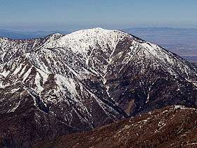 Snowy Mount Baden-Powell in the San Gabriel Mountains | |
| Highest point | |
| Peak | San Gorgonio Mountain |
| Elevation | 11,503 ft (3,506 m) |
| Coordinates | 34°05′57″N 116°49′29″W / 34.099162°N 116.824853°WCoordinates: 34°05′57″N 116°49′29″W / 34.099162°N 116.824853°W |
| Dimensions | |
| Length | 300 mi (480 km) |
| Geography | |
| Country | United States |
| Parent range | Pacific Coast Ranges |
The Transverse Ranges are a group of mountain ranges of southern California, in the Pacific Coast Ranges physiographic region in North America. The Transverse Ranges begin at the southern end of the California Coast Ranges and lie between Santa Barbara and San Diego counties. They derive the name Transverse Ranges due to their east–west orientation, making them transverse to the general north–south orientation of most of California's coastal mountains.[1][2]
Most of the system lies in the California chaparral and woodlands ecoregion. Lower elevations are dominated by chaparral and scrubland, while higher elevations support large conifer forests. Most of the ranges in the system are fault blocks, and were uplifted by tectonic movements during the Cenozoic Era. West of Tejon Pass, the primary rock types are varied, with a mix of sedimentary, volcanic, and metamorphic rocks, while regions east of the pass are dominated by plutonic granitic and metasedimentary rocks.
Geography
Most of the Transverse Ranges are bounded to the north and east by the San Andreas Fault, which separates the ranges from the California Coast Ranges and the Peninsular Ranges. Notable passes along the fault include Tejon Pass, Cajon Pass, and San Gorgonio Pass. Components of Transverse Ranges to the north of the fault include the Tehachapi Mountains and the San Bernardino Mountains. The western and southern boundaries are generally acknowledged to be the Pacific Ocean and various alluvial valleys and basins. Major passes not along the San Andreas Fault include Gaviota Pass, San Marcos Pass, the Conejo Grade, Newhall Pass, and Cahuenga Pass.
The mountains are notable for being steep and difficult to traverse across. On its northern end, there are few passes that are sufficiently low or wide enough to accommodate significant volumes of traffic. This has resulted in situations where major cities are linked to the rest of the state by relatively few number of roads; for example, the vast majority of traffic between the Central Valley and the Los Angeles area is routed through Tejon Pass. This results in significant traffic issues throughout Southern California when a pass has to be shut down due to heavy snow or construction. Occasionally, such as Santa Barbara during the 2005 La Conchita landslide, major cities may be cut off from timely road access to the rest of Southern California.
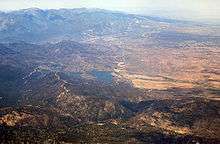
The Transverse Ranges manifest themselves as a series of roughly parallel ridges with an average height of 3,000–8,000 feet (910–2,440 m). The ranges are dissected by young, steep streams of relatively low flow rate; as a result, there is high topographic relief throughout the range, and other than in marginal areas (e.g. the San Fernando Valley) and a few river valleys (such as Lockwood Valley and Big Bear Valley), there are no large, flat basins within the ranges.
Peaks
Major peaks of the Transverse Ranges with at least 500 feet (150 m) of prominence, listed by height:
- Mount San Gorgonio, 11,503 feet (3,506 m), San Bernardino Mountains.
- Anderson Peak, 10,840 feet (3,300 m), San Bernardino Mountains.
- Mount San Antonio (Old Baldy), 10,068 feet (3,069 m), San Gabriel Mountains.
- Sugarloaf Mountain, 9,952 feet (3,033 m), San Bernardino Mountains.
- Mount Baden-Powell, 9,407 feet (2,867 m), San Gabriel Mountains.
- Galena Peak, 9,324 feet (2,842 m), San Bernardino Mountains.
- Throop Peak, 9,142 feet (2,786 m), San Gabriel Mountains.
- Telegraph Peak, 8,985 feet (2,739 m), San Gabriel Mountains.
- Cucamonga Peak, 8,862 feet (2,701 m), San Gabriel Mountains.
- Mount Pinos, 8,847 feet (2,697 m) San Emigdio Mountains.
- Ontario Peak, 8,693 feet (2,650 m), San Gabriel Mountains.
- Delamar Mountain, 8,402 feet (2,561 m), San Bernardino Mountains.
- Cerro Noroeste, 8,280 feet (2,520 m), San Emigdio Mountains.
- Mount Islip, 8,254 feet (2,516 m), San Gabriel Mountains.
- Gold Mountain, 8,239 feet (2,511 m), San Bernardino Mountains.
- Bertha Peak, 8,205 feet (2,501 m), San Bernardino Mountains.
- Frazier Mountain, 8,017 feet (2,444 m), San Emigdio Mountains.
- Iron Mountain #1, 8,010 feet (2,440 m), San Gabriel Mountains.
- Reyes Peak, 7,510 feet (2,290 m), Pine Mountain Ridge.
- Haddock Mountain, 7,431 feet (2,265 m), Pine Mountain Ridge.
Ranges
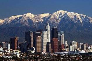
The Transverse ranges run predominantly east–west, while the other coast ranges tend north–south, including the Central Coast Ranges to the north and the Peninsular Ranges to the south. They begin at Point Conception in Santa Barbara County, and include the Santa Ynez Mountains that run parallel to the coast behind Santa Barbara. Also in Santa Barbara County, they include the San Rafael Mountains and the Sierra Madre Mountains, both of which extend approximately to the Ventura County line. The Transverse Ranges also include the Topatopa Mountains and the Santa Susana Mountains of Ventura County and Los Angeles County, the Simi Hills, the Santa Monica Mountains that run along the Pacific coast behind Malibu, and whose eastern portion are known as the Hollywood Hills, and the Chalk Hills.
The Ranges include the steep San Gabriel Mountains northeast of Los Angeles, the San Rafael Hills, Puente Hills, San Jose Hills, and Chino Hills, and the San Bernardino Mountains. To the north of the Transverse ranges are the Central Coast Ranges, The Central Valley, and the Tehachapi Mountains, which separate the Central Valley from the Mojave Desert to the east, and link the Transverse ranges to the Sierra Nevada. The Mojave Desert and California's low desert, including the Coachella Valley, are at the eastern end of the ranges. The northern Channel Islands of California are also part of the Transverse Ranges; San Miguel, Santa Rosa, Santa Cruz and Anacapa Islands are a westward extension of the Santa Monica Mountains.
|
Mountain ranges with peaks exceeding 4,500 feet (1,400 m), listed west to east, include: |
Examples of smaller mountain and hill ranges include: |
Climate
The climate in most of the range is Csb (Warm-summer Mediterranean) under the Köppen climate classification; the upper reaches of San Gorgonio Mountain have an alpine tundra climate (ET), while the lower northern slopes of the range have a desert (BW) or steppe (BS) climate.[3]
Snow falls above 6,000 feet (1,800 m) most winters, and above 3,000 feet (910 m) every few years. It is rare for elevations above 8,000 feet (2,400 m) to go multiple winters without snow, even during severe droughts. Due to relatively low humidity, the regional snow line lies at about 14,000–16,000 feet (4,300–4,900 m), above the highest elevation of the range; as such, snow does not persist year-round except in the form of snow patches.
The tree line lies at about 11,000 feet (3,400 m); San Gorgonio Mountain is the only peak with an alpine environment.
| Climate data for Big Bear Lake, California (1981–2010 normals) | |||||||||||||
|---|---|---|---|---|---|---|---|---|---|---|---|---|---|
| Month | Jan | Feb | Mar | Apr | May | Jun | Jul | Aug | Sep | Oct | Nov | Dec | Year |
| Average high °F (°C) | 47.0 (8.3) |
47.1 (8.4) |
52.1 (11.2) |
58.7 (14.8) |
68.1 (20.1) |
76.2 (24.6) |
81.2 (27.3) |
79.8 (26.6) |
74.1 (23.4) |
64.0 (17.8) |
54.4 (12.4) |
47.6 (8.7) |
62.53 (16.97) |
| Daily mean °F (°C) | 34.1 (1.2) |
34.6 (1.4) |
38.6 (3.7) |
43.9 (6.6) |
51.9 (11.1) |
59.0 (15) |
64.7 (18.2) |
63.6 (17.6) |
57.9 (14.4) |
48.5 (9.2) |
40.3 (4.6) |
34.5 (1.4) |
47.63 (8.7) |
| Average low °F (°C) | 21.2 (−6) |
22.1 (−5.5) |
25.0 (−3.9) |
29.1 (−1.6) |
35.7 (2.1) |
41.8 (5.4) |
48.2 (9) |
47.4 (8.6) |
41.6 (5.3) |
33.0 (0.6) |
26.2 (−3.2) |
21.3 (−5.9) |
32.72 (0.41) |
| Average precipitation inches (mm) | 4.45 (113) |
3.91 (99.3) |
2.66 (67.6) |
.95 (24.1) |
.35 (8.9) |
.15 (3.8) |
.67 (17) |
1.04 (26.4) |
.42 (10.7) |
.94 (23.9) |
1.50 (38.1) |
3.01 (76.5) |
20.05 (509.3) |
| Average snowfall inches (cm) | 16.5 (41.9) |
18.1 (46) |
14.7 (37.3) |
4.1 (10.4) |
.5 (1.3) |
0 (0) |
0 (0) |
0 (0) |
.1 (0.3) |
1.2 (3) |
4.7 (11.9) |
12.3 (31.2) |
72.3 (183.6) |
| Average precipitation days (≥ 0.01 in) | 6.3 | 6.3 | 5.7 | 3.7 | 1.8 | .8 | 2.6 | 3.2 | 2.2 | 2.7 | 3.1 | 5.1 | 43.5 |
| Average snowy days (≥ 0.1 in) | 3.8 | 3.8 | 3.4 | 1.5 | .3 | .1 | 0 | 0 | 0 | .4 | 1.4 | 3.3 | 18.0 |
| Source: NOAA[4] | |||||||||||||
Geology
The Transverse Ranges have a complex geological history, and the rock composition of the ranges are varied.
Tectonics
The Transverse Ranges represent a complex of tectonic forces and faulting stemming from the interaction of the Pacific Plate and the North American Plate along the San Andreas Fault system. Their orientation along an east–west axis as opposed to the general southeast-northwest trend of most California ranges results from a pronounced step in the San Andreas Fault, the cause of which is a subject of intensive ongoing study. The San Andreas Fault is a dextral strike-slip fault with a right step, causing the mountains. Their elevation is somewhat better understood as a consequence of this step. The crust atop the Pacific Plate south of the ranges does not easily make the turn westward as the entire plate moves northwestward, forcing pieces of the crust to compress and lift.
The crust which comprises the Transverse Ranges is part of what is known as the Salinian Block, originally a piece of the North American Plate which was broken off what is now northwestern Mexico as the Gulf of California rifted open.
Physiographically, the Transverse Ranges are a distinct physiographic section of the larger Pacific Border province, which in turn is part of the larger Pacific Mountain System.[5] They exhibit extreme differences in geologic age and composition, varying from sedimentary rocks in the western Santa Ynez and Santa Monica mountains to primarily granitic and metamorphic rock in the eastern regions, where they terminate abruptly in the San Gabriel and San Bernardino mountains.[2]
Between this set of ranges and the Peninsular Ranges is the complex Malibu Coast—Santa Monica—Hollywood fault, which exists as the border between these two mostly geologically unitary provinces.[6]
Rocks
The rock types in the ranges are extremely varied. The oldest rocks are of Proterozoic age, and are found in the San Gabriel Mountains, the San Emigdio Mountains, and the San Bernardino Mountains. The Jurassic-Cretaceous Franciscan Assemblage is found in the western section of the ranges. Exposed plutonic rocks from the Mesozoic, mostly granites, can be found on Mount Pinos and generally in regions east of Tejon Pass. Finally, the youngest rocks are Cenozoic sedimentary and volcanic rocks that can be found throughout the ranges.[7]
Some limestones can be found in the Santa Ynez Mountains; these are remnants of ancient marine fossils. Some rhyolite dikes, presumably formed from rifting processes, can be found around the San Andreas Rift Zone.
Ecology

The plant place of the Transverse ranges include coastal sage scrub, oak woodland and savanna, and pinyon-juniper woodland at lower elevations, and yellow pine forest, Lodgepole Pine forest, and subalpine forest at higher elevations.[8] The Angeles and Los Padres National Forests cover portions of the Transverse ranges. The ranges are part of the California chaparral and woodlands ecoregion, but the eastern points of the range touch two desert regions, the Mojave Desert and the Colorado Desert section of the Sonoran Desert. The Carrizo Plain adjoins the northern edge of the Transverse Range.
Chaparral is a common feature of the Transverse Ranges. Common plant associates in chaparral, especially in the transition between coastal chaparral and coastal sage scrub, include California sagebrush and Toyon, the latter shrub having its southern distribution limit defined by the Transverse Ranges.[9]
Pinyon-juniper woodland is common on the north slopes of the San Gabriel and San Bernardino Mountains. This ecosystem is easily visible in the well-travelled Soledad Pass region, between Pearblossom and Santa Clarita.
Urban impact
A number of densely populated coastal plains and interior valleys lie between the mountain ranges, including the Oxnard Plain of coastal Ventura County, the Santa Clarita Valley north of Los Angeles, the San Fernando Valley, which is mostly included in the City of Los Angeles. The Los Angeles Basin, which includes the portion of Los Angeles County south of the Santa Monica Mountains and most of Orange County, and the Inland Empire basin, which includes the cities of San Bernardino and Riverside, lie between the Transverse Ranges and the Peninsular Ranges to the south.
Transportation

There are a number of important freeways that cross the Transverse Ranges, like (from west to east) US-101, I-5 at Tejon Pass, SR 14 at Soledad Pass, and I-15 at Cajon Pass. These highways link Southern California with places to the north and northeast like San Francisco and Las Vegas, respectively. With the exception of several high passes on less-traveled SR 33, SR 2, SR 330. SR 18 and SR 38, none of these passes are at high elevations, with Cajon Pass being at a modest 4,190 ft (1,277 m) above mean sea level; this means that snow is less of a factor here than in the moderate to high mountain passes to the north like Donner Pass. Still sometimes, heavy snowfall can snarl traffic on Tejon and Cajon Pass, the higher two of the three freeway passes. I-5 and I-15 commonly experience heavy traffic over their mountainous route across these mountains.
See also
- Southern California faults
- Transverse Ranges topics index
- Peninsular Ranges
References
- ↑ Ingram, Scott (2002). California: The Golden State. Gareth Stevens. p. 21. ISBN 0-8368-5282-6.
- 1 2 "California's Coastal Mountains". California Coastal Commission. Retrieved 2007-12-25.
- ↑ Redlands Biology
- ↑ "NowData - NOAA Online Weather Data". National Oceanic and Atmospheric Administration. Retrieved 2013-07-03.
- ↑ "Physiographic divisions of the conterminous U. S.". U.S. Geological Survey. Retrieved 2007-12-06.
- ↑ Meigs, Andrew J.; Oskin, Michael E. (2002). "Convergence, block rotation, and structural interference across the Peninsular-Transverse Ranges boundary, eastern Santa Monica Mountains, California". In Barth, Andrew. Contributions to Crustal Evolution of the Southwestern United States. Geological Society of America. pp. 281–7. ISBN 978-0-8137-2365-5.
- ↑ USGS
- ↑ Schoenherr, Allan A. (1992). A Natural History of California. Berkeley, CA: University of California Press.
- ↑ C. Michael Hogan, (2008) Toyon (Heteromeles arbutifolia), GlobalTwitcher, ed. N. Stromberg
Further reading
- U.S. Geological Survey. (1987). Recent reverse faulting in the Transverse Ranges, California [U.S. Geological Survey Professional Paper 1339]. Washington, D.C.: U.S. Government Printing Office.
External links
- Plio-Pleistocene Tectonic Shortening of the Transverse Ranges, block model animation by Tanya Atwater
| Wikimedia Commons has media related to Transverse Ranges. |