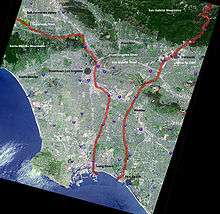
San Gabriel Valley
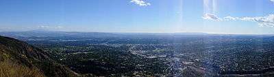
The San Gabriel Valley is one of the principal valleys of Southern California, lying generally to the east of the city of Los Angeles. Surrounding features include:
- San Gabriel Mountains on the north,[1]
- San Rafael Hills to the west,[2] with Los Angeles Basin beyond; San Fernando Valley and Crescenta Valley farther to the northwest,
- Puente Hills to the south,[3] with the coastal plain of Orange County beyond,
- Chino Hills and San Jose Hills to the east, with the Pomona Valley and Inland Empire beyond.
The valley derives its name from the San Gabriel River that flows southward through the center of the valley, which itself was named for the Spanish Mission San Gabriel Arcángel originally built in the Whittier Narrows in 1771.
At one time predominantly agricultural, the San Gabriel Valley is today almost entirely urbanized and is an integral part of the Greater Los Angeles metropolitan area. It is one of the most ethnically diverse regions in the country. About 200 square miles (520 km2) in size, the valley includes thirty-one cities and five unincorporated communities.[4]
In 1886, Pasadena was the first independent incorporated city still located in Los Angeles County (both Anaheim and Santa Ana are now located in Orange County).
Cities and communities
The San Gabriel Valley is in Los Angeles County. The incorporated cities and unincorporated neighborhoods of the San Gabriel Valley include:
- Altadena
- Alhambra
- Arcadia
- Avocado Heights
- Azusa
- Baldwin Park
- Bassett
- Bradbury
- Charter Oak
- Citrus
- City of Industry
- Claremont
- Covina
- Diamond Bar
- Duarte
- East Pasadena
- El Monte
- Glendora
- Hacienda Heights
- Hillgrove
- Irwindale
- La Cañada Flintridge
- La Puente
- La Verne
- Mayflower Village
- Monrovia
- Monterey Park
- North El Monte
- Pasadena
- Pomona
- Rosemead
- Rowland Heights
- San Dimas
- San Gabriel
- San Marino
- Sierra Madre
- South El Monte
- South Pasadena
- South San Gabriel
- South San Jose Hills
- Temple City
- Valinda
- Vincent
- Walnut
- West Covina
- West Puente Valley

Whittier, like Montebello, is considered both a San Gabriel Valley city and part of the Gateway Cities region.[5] Some of Whittier sits below the Puente Hills. Although these hills are small compared to the San Gabriel Mountains, the fact that most of the city sits around them makes Whittier a San Gabriel Valley city. This is similar to Montebello, which is a member of the Gateway Cities Council of Governments, despite geographically being part of the San Gabriel Valley.[6]
Claremont, Diamond Bar, La Verne, Pomona, San Dimas and Walnut are adjacent to the San Gabriel Valley, and although are properly considered part of the Pomona Valley, they are also commonly considered[5] part of the San Gabriel Valley. The 57 Freeway (Orange Freeway) is generally considered[5] the dividing line between the Pomona and San Gabriel valleys. However, for statistical and economic development purposes, the County of Los Angeles generally includes these six cities as part of the San Gabriel Valley.[5] The community of El Sereno, in the city of Los Angeles, is situated at the westernmost edge of the Valley. Unofficial estimates[5] place the combined population of the San Gabriel Valley at around 2 million—roughly a fifth of the population of Los Angeles County.
Early history
Before the arrival of the Spaniards, the land along the Rio Hondo River, a branch of the San Gabriel River, was populated by the Tongva[7] part of the Uto-Aztecan family Native Americans. The Tongva occupied much of the Los Angeles basin and the islands of Santa Catalina, San Nicolas, San Clemente and Santa Barbara. In the northern part of the valley were the Hahanog-na[8] Indian tribe, a branch of the Tongva Nation (part of the Shoshone language group) who lived in villages scattered along the Arroyo Seco and the canyons from the mountains down to the South Pasadena area. In 1542,when the Portuguese explorer João Rodrigues Cabrilho arrived off the shores of San Pedro and Santa Catalina.[9] The Tongva were the people who rowed the remarkable Ti'ats (plank canoes) out to meet Cabrilho.[7] The language of the Tongva was different from the neighboring Indian tribes and it was called Gabrielino by the Spanish. The Tongva also provide the origin of many current names; Piwongna – Pomona, Pasakeg-na – Pasadena, Cucomog-na – Cucamonga. The Gabrielinos lived in dome-like structures with thatched exteriors. Both sexes wore long hair styles and tattooed their bodies. During warm weather the men wore little clothing, but the women would wear minimal skirts made of animal hides. During the cold weather they would wear animal skin capes. European diseases killed many of the Tongva and by 1870 the area had few remaining native inhabitants. Today, several bands of Tongva people live in the Los Angeles area.[7]
The first Europeans to see inland areas of California were the members of the 1769 Portolà expedition, which traveled north by land after establishing the first Spanish settlement in today's state of California at San Diego. On July 30, the expedition crossed the San Gabriel River and continued north toward what is now the city of Los Angeles. To cross the river, the expedition built a rough bridge, which gave the name La Puente to today's San Gabriel Valley city, and hills to the south are called the Puente Hills. A few years later, a mission was established near the river crossing.

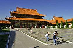
Mission San Gabriel Arcangel was founded by Franciscan Father Junipero Serra, first head of the Spanish missions in California, on September 8, 1771. Its original location was near where San Gabriel Boulevard now crosses the Rio Hondo, which is also near the present day Juan Matias Sanchez Adobe.[10] Angel Somera and Pedro Cambon were the first missionary priests at the new mission, which marked the beginning of the Los Angeles region's settlement by Spaniards. The San Gabriel mission was the third of twenty-one[11] missions that would ultimately be established along California's El Camino Real.
The San Gabriel mission did well in establishing cattle ranching and farming, but six years after its founding a destructive flood led the mission fathers to relocate the establishment to its current location farther north in present-day city of San Gabriel. The original mission site is now marked by a California Historical Landmark.[12]
During the early years of the mission, the region operated under a Rancho system. The lands which now compose the city of Montebello were originally parts of Rancho San Antonio, Rancho La Merced, and Rancho Paso de Bartolo. The Juan Matias Sanchez Adobe, built in 1844, remains standing at the center of old Rancho La Merced in Eastern Montebello in the La Merced area. Recently restored, it is the city's oldest structure.
Mission San Gabriel Arcángel served a central role in Spanish colonial society, with many of the area's first Mexican settlers being baptized at the mission, including Pio Pico, who was born and baptized at the mission in 1801. He became governor of California twice, in 1832 and in 1845 and the city of Pico Rivera was named honoring him as the last Mexican governor of California.
The Battle of Rio San Gabriel took place in Montebello on January 8, 1847 on the banks of the Rio Hondo.[13] This battle gave the control of Los Angeles and Alta California to the United States, and was a decisive battle in the Mexican-American war. Two days later, after several battle losses and defeats, Mexico was forced to cede Alta California to the United States. By 1852, after American occupation, San Gabriel became one of the first townships in the County of Los Angeles. Today the battle site is California State Historical Landmark #385, and there are two old cannons and a plaque commemorating the battle overlooking the river on Bluff Rd. and Washington Blvd.[14]
In 1853, with a contingent of Army Engineers passing through searching for the best route to build a railroad, Geologist William P. Blake observed that the once-extensive vineyards were falling to decay, with fences broken down and animals roaming freely through it. But the bells were ringing, and the church was in use. Prophetically, he wrote, "I believe that when the adaptation of that portion of California to the culture of the grape and the manufacture of wine becomes known and appreciated, the state will become celebrated not only for its gold and grain, but for it fruits and wines.[15]
Following the American Civil War, some 5,000 acres (20 km2) of the East Los Angeles region were owned by an Italian settler from Genoa, Alessandro Repetto. After Repetto's death in 1885, his brother sold his rancho to a consortium of five Los Angeles businessmen including banker Isaias Hellman and wholesale grocer/historian Harris Newmark for $60,000, about $12 an acre.[13]
Chinese, Japanese, Filipino, and South Asian pioneers and settlers first came to the San Gabriel Valley in the mid-19th century. These pioneers worked the fields, picked the grapes and citrus fruit, and built part the infrastructure of today’s San Gabriel Valley.[16] In the 1920s Japanese immigrants arrived in Monterey Park to work as farmhands.
The discovery of oil by Standard Oil Company in the Montebello hills, in 1917, brought about a revolutionary change to the locality. The agricultural hills soon became a major contributor to oil production. By 1920, its oil fields were producing one-eighth of California's crude oil. For several decades, the hills were dotted with active oil wells.[13]
The cities of Whittier, Covina and Pasadena were formerly the sites of the citrus industry. In addition, the oil, dairy and cattle industries used to flourish in the southern region of the SGV. Many equestrian trails in the San Gabriel Valley—specifically, in Covina and Walnut—have disappeared or fallen into disuse. The remaining rural countryside-like areas include the area between eastern West Covina and Cal Poly Pomona and in Walnut and Diamond Bar and La Puente.
Timeline

- 1769: First Europeans pass through in the Spanish Portola Expedition.
- 1771: Mission San Gabriel established. The entire valley eventually becomes mission-controlled ranch and agricultural land. Native tribes are absorbed into the mission system.
- 1774: First Europeans reach the valley from the east, an expedition led by Juan Bautista de Anza.
- 1834: With the secularization of the missions, former mission lands are divided into large land grants called ranchos.
- 1886: Los Angeles and San Gabriel Valley Railroad opens.
- 1890: The first Tournament of Roses Parade is presented in Pasadena.
- 1914: Erection of the first two tents which were the first building blocks of today’s City of Hope National Medical Center
- 1920: The California Institute of Technology or Caltech opens in Pasadena (previously Throop College of Technology, est. 1891).
- 1941: The first freeway in the United States, Arroyo Seco Parkway (now part of California 110, north of downtown Los Angeles), opens.
- 1942–1944 Japanese American citizens were sent to a Japanese internment camp at Santa Anita Park during World War II, with up to 17,000 people living in horse stables.
- 1940s1950s: San Gabriel Valley changes from acres of farmland to suburban bedroom community.
- 1957: San Bernardino Freeway (Interstate 10) opens.
- Late 1960s: Chicano Movement protests by local Mexican Americans in El Monte.
- 1970s–1980s: Taiwanese immigrants began settling in Monterey Park and its neighborhoods.
- 1980s–present Chinese and Hong Kong immigrants began to settle in Alhambra, Arcadia, El Monte, Monterey Park, Rosemead, and San Gabriel.
Demographics and ethnic diversity
The total population of the San Gabriel Valley in the 2000 Census was 1,510,378 people, of which 1,425,596 were living in the 30 incorporated cities. Estimates for the 2010 census put the population at over 2 million.[17]
The average size of a household in the San Gabriel Valley according to the 2000 Census was 3.28 persons compared with 2.98 persons for Los Angeles County as a whole. Eight cities in the Valley have average household sizes of over 4 persons, while an unincorporated area, the South San Jose Hills, was at a significant 5.07 persons per household. (Most addresses do not use South San Jose Hills as the city but use La Puente, West Covina, or Valinda.) At the other end of this scale is Sierra Madre at 2.20 persons per household.[18]
The age distribution in the San Gabriel Valley was a little unusual when compared with the County. A larger share of the population was aged 10–19, 15.5% versus 14.8% for the County. Also, the Valley had a higher share of people over 45 years of age. The income ranges in the San Gabriel Valley area are also quite wide. The highest median household income was found in San Marino ($117,267), followed by La Cañada Flintridge ($109,989), and Bradbury ($100,454). At the other end of the scale was El Monte with a median household income of $32,439. Four other cities in the Valley had household incomes of less than $40,000.[19]
Significant percentages of all major ethnic groups reside in San Gabriel Valley communities, and the area is in general one of the most ethnically diverse regions in the country. The majority of people residing in the San Gabriel Valley are Hispanics and Asian Americans.[16][20][21] The communities of Glendora, La Verne, Claremont, Monrovia, San Marino, Sierra Madre, Pasadena, South Pasadena, and San Dimas have a significant Caucasian population. This area has also known to be very affluent.[21]
The African American population in the San Gabriel Valley is relatively low. However, there are sizable, long-established African American communities in the western Altadena area and in northwest Pasadena, as well as in Monrovia.[22]
Montebello is home to the oldest Armenian Community in Los Angeles County and home to previously, the only Armenian Cathedral in California, Holy Cross Armenian Apostolic Cathedral until the Saint Leon Cathedral was built in Burbank in 2012 .[23] The Armenian Martyrs Monument at Bicknell Park commemorating the victims of the Armenian Genocide by the Ottoman Turks is the largest monument of the genocide found on public property in the world.[24] The Armenian community of Pasadena has its roots in the 1890s. The Pashgian Bros. Oriental Rugs and Fine Carpets was established in 1889.
Hispanics, predominately Mexican Americans, are concentrated in Azusa, Alhambra, Baldwin Park, City of Industry, El Monte, La Puente, Montebello, Rosemead, San Gabriel, South El Monte, West Covina, Covina, Pomona, and Whittier, with significant populations in Pasadena and South Pasadena.
The San Gabriel Valley has the largest concentration of Asian American communities in the United States.[25] Eight of the ten cities in the United States with the largest proportion of Chinese Americans are located in the San Gabriel Valley.[25] The cities of Monterey Park, Walnut, Alhambra, San Gabriel, San Marino, Rowland Heights, Hacienda Heights, Diamond Bar, and Arcadia contain an Asian American majority. This region is a very affluent region of the San Gabriel Valley.[26] "New" Chinatowns have been established in many cities in the San Gabriel Valley.
The Gabrieleno/Tongva of San Gabriel are headquartered in San Gabriel.[7] A small Native American population is also located in Arcadia, Rowland Heights, Walnut, and Diamond Bar. Despite the European influx they remained an integral part of the Southern California community, and continue to in the present day.[7]
There are many Filipino Americans, residing in West Covina and Walnut. Vietnamese Americans tend to be concentrated in San Gabriel, Rosemead, and El Monte. Many Korean Americans live in Hacienda Heights, Rowland Heights, and Diamond Bar. A longstanding Japanese American community exists in Monterey Park.
Asian American influx
Early Chinese pioneers settled into the Valley mostly as laborers. They packed oranges, picked walnuts, did construction, owned or worked in laundries, and worked as cooks and servants in the homes of the wealthy. Mostly a bachelor society, the early Chinese did not leave many descendants. By the late 1880s, there was a growing Japanese pioneer population. Filipinos and Asian Indians also served as laborers in the Valley.
Almost a century later, in the wake of the San Gabriel Valley's burgeoning population of Asian Americans, they have become a dominant cultural force.[27] Several business districts were developed to serve their needs creating a collection of Southern California Chinatowns loosely connected along the Valley Boulevard Corridor. This trend began in the city of Monterey Park during the late 1970s when many well-to-do Taiwanese professionals, began settling in the area. Initially, many Chinese restaurateurs and business owners at the time used primarily Traditional Chinese script and not English names on their business signs. This changed in 1986, when the city council of Monterey Park enacted an ordinance requiring the all businesses to translate their business signs and describe the nature of their businesses in English, deemed a matter of public safety.
Monterey Park is a microcosm of changing demographics, highlighting Asian American history and evolution in the San Gabriel Valley. Rosemead has a smaller group of Vietnamese and Chinese business districts. There are also small pockets of Chinese American businesses that are scattered throughout San Gabriel Valley cities. In Rowland Heights, a handful of Korean American strip malls co-exist with Chinese American businesses. Another ethnic enclave is the Filipino American business district of Little Manila, in West Covina along with an Asian indoor and outdoor shopping center. Small Chinatowns have sprung up in many cities throughout the valley.
Local interest
The San Gabriel Valley is home to the annual Tournament of Roses Parade, which is broadcast live on television on New Year's Day from Pasadena. After the parade, the Rose Bowl game between two rival college football teams is also televised live.[28]
As the oldest incorporated community in the valley, the City of Pasadena serves as a cultural center for the San Gabriel Valley.[29] Several art-house film and play theatres are located in Pasadena, including the Pasadena Playhouse.[30] In addition, the local news/talk National Public Radio station KPCC 89.3 FM broadcasts from Pasadena City College, although it is operated by Minnesota Public Radio.[31]
Old Town Pasadena, which has been restored and rejuvenated, remains highly popular.[32] Old Town has an active nightlife, a shopping mall, boutiques, outdoor cafés, nightclubs, comedy clubs, and varied restaurants. Other communities hope to emulate its successes through commercial redevelopment and reviving their own downtown areas or "Main Streets".
The city of Azusa has attempted to encourage redevelopment of its once-dilapidated downtown section by using a Route 66 theme. Covina has had moderate success with its nostalgic Downtown Covina, with emphasis placed on a small-town America atmosphere and mom-and-pop merchants rather than big-box retail chains; Monrovia has also embraced this theme for their "Old Town."[33] Alhambra has also worked to renovate its downtown along Main St.[34] San Gabriel Mission is the center of Historical Culture in SGV.
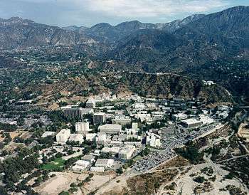
The California Institute of Technology is located in Pasadena. The university is ranked in the top 10 universities worldwide by metrics such as citation index, Nobel Prizes, and general university rankings. Caltech is also responsible for the well-known Jet Propulsion Laboratory, which designs and engineers many of NASA's spacecraft.[35]
The city of Baldwin Park is the birthplace of the popular hamburger fast food chain In-N-Out Burger. Its first location opened in the city in 1948.[36]
Huy Fong's Sriracha sauce, the ubiquitous Sriracha sauce found at Vietnamese restaurants across the western world, manufactures and is headquartered in Irwindale.[37]
Naked Juice, now a division of PepsiCo, is headquartered in Monrovia
Panda Express was launched as a fast food version of the Panda Inn restaurant in Pasadena in 1983. The company's headquarters are in Rosemead
Trader Joe's opened its first location in Pasadena in 1967. The company's headquarters are in Monrovia.
Politics and government
Most cities have their own local mayor, city council, police and fire departments. Unincorporated areas such as Hacienda Heights and Rowland Heights are governed by the Los Angeles County Board of Supervisors, and the Los Angeles County Sheriff's Department has jurisdiction in these areas.
In many unincorporated areas, advisory town councils guide the decisions, made by a supervisor or city manager. Often these groups began as collaborations of local homeowners' associations. The Hacienda Heights Improvement Association, Rowland Heights Coordinating Council, and Altadena Town Council are examples of advisory bodies that are officially sanctioned by the county supervisor representing that community.
In 2003, voters in the unincorporated community of Hacienda Heights defeated a proposal to incorporate as a city. It remains an unincorporated district governed by the Los Angeles County Board of Supervisors rather than by a locally elected mayor and city council.
Transportation

Foothill Transit and the Los Angeles County Metropolitan Transportation Authority provide bus transit services throughout the valley. El Monte Station, a large regional bus station, provides transportation to Union Station in downtown Los Angeles via the El Monte Busway, an 11-mile (18 km) shared-use bus corridor (transitway).[18] The Metrolink San Bernardino Line commuter train runs westward to Downtown Los Angeles and eastward to San Bernardino through the valley.
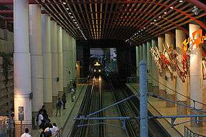
On March 5, 2016 the Los Angeles County Metropolitan Transportation Authority opened the Metro Gold Line foothill extension, expanding the current light rail service that previously traveled from East LA to Pasadena through Downtown LA to a new Northern terminus in Azusa.[38]
Several cities provide their own in-city transportation shuttles. Cities known to provide such service are:
- Alhambra[39]
- Arcadia[40]
- Baldwin Park[41]
- Duarte[42]
- Glendora[43]
- La Puente[44]
- Monrovia[45]
- Montebello[46]
- Monterey Park[47]
- Pasadena[48]
- Temple City[49]
- West Covina[50]
The San Gabriel Valley is served by several major freeways:
- the Foothill Freeway (Interstate 210 (California) and State Route 210)
- the Ventura Freeway (State Route 134)
- the San Bernardino Freeway (Interstate 10)
- the Pomona Freeway (State Route 60)
- the Pasadena Freeway (State Route 110)
- the Long Beach Freeway (Interstate 710)
- the San Gabriel River Freeway (Interstate 605)
- the Orange Freeway (State Route 57)
I-710 ends abruptly at the western border of Alhambra, near California State University, Los Angeles. A small noncontiguous and mostly unsigned spur of I-710 starts again at California Boulevard in Pasadena and ends at the junction of I-210 and SR 134. Since the late 1950s, the plan to connect the two portions of I-710 (formerly SR 7) has generated a long, contentious debate, as well as prolonged litigation. Many residents in South Pasadena fear losing their homes, some of them historically precious Craftsman, and businesses to clear the way for construction. The MTA and Caltrans, an ardent proponent of the extension, has recently proposed the idea of constructing an underground tunnel to complete the so-called "710 gap." Because the entire valley suffers from severe traffic congestion, the I-710 completion plan is a major issue in the politics of all valley cities, and political candidates at all levels of government routinely assert positions on the issue.
At the end of the San Gabriel Valley, the eastern freeway segment of SR 210 (formerly designated SR 30 and still signed as such in some places in San Bernardino County) between SR 57 and I-15 had been a source of similar contention in the bordering community of La Verne, but was finally constructed and added to the Foothill Freeway in 2002.
State Route 39 leads north into the San Gabriel Mountains to the Crystal Lake Recreation Area.[51] The portion connecting the recreation area to the Angeles Crest Highway (State Route 2) has been closed to the public since the early 1970s due to massive damage and rockslides.
General aviation is served by El Monte Airport (EMT) in El Monte, and Brackett Field (POC) in Pomona.
Local media
Newspapers and online media
- See also Los Angeles Times suburban sections
The local daily English-language newspapers are the The Los Angeles Times which include a real estate and automotive advertising sections for the San Gabriel Valley/Inland Empire, the San Gabriel Valley Tribune and the Pasadena Star-News, which operate from the Monrovia office. The Pasadena Star-News covers the Pasadena area and the Tribune covers the central and eastern San Gabriel Valley communities. Business news is covered by the San Gabriel Valley Business Journal.
Other San Gabriel Valley-wide publications include the weekly Mountain Views News serves the foothill communities, The Mid Valley News which serves the central San Gabriel Valley, and the Beacon Media weekly newspaper chain, whose weekly newspapers cover several San Gabriel Valley cities, while the South Pasadena Review serves South Pasadena, and the San Marino Tribune serves San Marino. Additionally, the cities of Alhambra, Glendora, Azusa, San Dimas and La Verne have monthly Community News papers that come out the first Friday of every month since the mid-1990s. These papers include Around Alhambra, Glendora Community News, Azusa Community News, San Dimas Community News and the La Verne Community News, all direct mailed. The Alhambra Source[52] is a USC Annenberg-backed community news site founded in 2010. The site is based on research into local information needs, and includes a multilingual cadre of volunteer and young adult contributors. It publishes online every weekday and includes select content in Spanish and Chinese, as well as English. In the east part of the valley, Claremont has their own community news paper called the Claremont Courier.
Several large newspaper publishing companies serve the large Chinese-speaking readership in the Greater Los Angeles Area; a number of them are based in the San Gabriel Valley. The national daily Chinese-language newspapers Chinese Daily News (Los Angeles edition of the World Journal newspaper) and International Daily News are both printed in Monterey Park. The Los Angeles edition of the Hong Kong-based Sing Tao is printed in Alhambra and the newspaper is specifically tailored to the Cantonese-speaking readership. The Epoch Times (大纪元) is based in New York City and has its Los Angeles office in San Gabriel. These newspapers are circulated and distributed throughout Chinese American communities in the San Gabriel Valley, Chinatown, San Diego, and in Las Vegas, Nevada (where the latter two cities generally receive the Los Angeles editions due to a relatively lower population density of Chinese-speaking Americans).
Filming locations
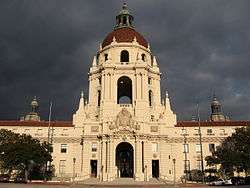
Several blockbuster Hollywood films have been filmed on location in the San Gabriel Valley. Chantry Flats above Arcadia is featured as the landing site of aliens in the original film "War of the Worlds". South Pasadena and Alhambra served as the gloomy backgrounds of a fictional Illinois town of Haddonfield in John Carpenter's 1978 horror film Halloween. Some areas of Pasadena and South Pasadena have a distinctly Midwestern look. Pasadena's distinctive domed City Hall has doubled as a courthouse or capitol building in countless television commercials and movies, and its South Lake shopping district filled in for Rodeo Drive in Beverly Hills Ninja.
The city of San Marino has taken acted as a backdrop for a number of films and television shows. Major studio motion pictures filmed in San Marino include Mr. & Mrs, Smith, Disturbia, Enough, Monster-in-Law, Memoirs of a Geisha, Frailty, Men in Black II, The Hot Chick, One Hour Photo, Anger Management, The Wedding Planner, Starsky & Hutch, Intolerable Cruelty, Mystery Men, Legally Blonde 2, The Nutty Professor, Beverly Hills Ninja, The Sweetest Thing, S1m0ne, Charlie's Angels, Indecent Proposal, and American Wedding. Prime time television programs filmed within city borders include Felicity, The Office, The West Wing, and Alias. In addition, San Marino High School students in the graduating classes of 2004 and 2005 were documented in two separate reality television programs by MTV, which aired on the cable television network in 2005.
The cities of Temple City and Rosemead served as the backdrop for the Emmy Award winning television series The Wonder Years (1988 to 1993). While Temple City's Las Tunas Drive served as the downtown for the Arnold Family's fictitious hometown, Rosemead High School stood in for the town's high school. Downtown Covina was used in the show "Roswell."
The city of Whittier also hosts film crews for various motion picture, television and feature films. In Robert Zemeckis' Back to the Future trilogy of time travel adventure movies (1985, 1989, 1990), Whittier High School was used as Hill Valley High School. Michael J. Fox's character travels back in time on the huge parking lot of the Puente Hills Mall in the City of Industry that served as the location of the fictitious Twin Pines Mall / Lone Pine Mall. The Gamble House in Pasadena provided the exterior of Christopher Lloyd's character's 1950s mansion. The city of El Monte served as a dilapidated future neighborhood. Another movie starring Fox, Teen Wolf. was largely filmed in Arcadia. The Pasadena Chapter building of the Red Cross served as JAG Headquarters for the TV series JAG, and the Caltech campus is regularly seen as the "Cal Sci" campus in the TV series Numb3rs. The actual house used as the residence of the main characters is also located in the southern end of Pasadena. Uptown Whittier was a principal location for the 1987 release Masters of the Universe, and many scenes of the film show the buildings of the neighborhood as they appeared before most of them were damaged or destroyed by the Whittier Narrows earthquake of that year. Forrest Gump (1994), starring Tom Hanks, was partially filmed at East Los Angeles College in Monterey Park. The downtown portion of Myrtle Avenue in Monrovia has been used in many movies and television commercials. Multiple locations throughout Monrovia also played the role of the fictitious Rome, WI in the TV series Picket Fences.Pinky's Record Store in Friday; The 90s television show Roswell filmed in Covina, most noticeably the downtown area. Most recently, the former location of a now closed Ikea in the City of Industry was used to film scenes in the movie Mr. & Mrs. Smith (2005), starring Angelina Jolie and Brad Pitt. Across the street from the defunct Ikea is Speed Zone, an amusement center with 4 race tracks, it has been featured in the films Guess Who and Clerks 2 and on TV in Melrose Place (2009 TV series), Coordinates: 34°06′07″N 118°06′10″W / 34.10194°N 118.10278°W CSI: Miami, Hell's Kitchen, Attack of the Show!, Freaks And Geeks, and more.[53]
Climate
Like much of the Los Angeles region, the San Gabriel Valley enjoys a warm, sunny, and Mediterranean-like climate year-round. Rain is sporadic. Due to the Eastern San Gabriel Valley, (East of State Route 57) being more inland, the area is subject to hotter summers and colder winters. Light snow is extremely rare in the Valley but can often be viewed on the nearby San Gabriel Mountains.
| Climate data for Baldwin Park, California: one of the cities in the San Gabriel Valley | |||||||||||||
|---|---|---|---|---|---|---|---|---|---|---|---|---|---|
| Month | Jan | Feb | Mar | Apr | May | Jun | Jul | Aug | Sep | Oct | Nov | Dec | Year |
| Average high °F (°C) | 70 (21) |
71 (22) |
72 (22) |
77 (25) |
79 (26) |
84 (29) |
89 (32) |
90 (32) |
88 (31) |
83 (28) |
76 (24) |
71 (22) |
75 (24) |
| Average low °F (°C) | 43 (6) |
45 (7) |
47 (8) |
50 (10) |
55 (13) |
59 (15) |
62 (17) |
63 (17) |
61 (16) |
55 (13) |
46 (8) |
42 (6) |
50 (10) |
| Source: weather.com[54] | |||||||||||||
Institutions of higher learning
"The San Gabriel Valley is home to leading educational institutions including the California Institute of Technology (Caltech) and California State Polytechnic University, Pomona (Cal Poly)."[55]
- Alliant International University, private (for-profit) - Alhambra
- Art Center College of Design, private, nonprofit - Pasadena
- Azusa Pacific University (APU), private university - Azusa
- California Institute of Technology (Caltech), private university - Pasadena
- California State Polytechnic University, Pomona (Cal Poly Pomona), public university - Pomona
- California State University, Los Angeles, public university - Los Angeles
- Irell & Manella Graduate School of Biological Sciences, private, not-for-profit graduate school located at the City of Hope in Duarte
- Claremont Graduate University, private graduate university - Claremont
- Claremont McKenna College, private college - Claremont
- Citrus College, community college - Glendora
- Digital Business & Design College (DBD), private (for-profit) college - El Monte
- East Los Angeles College (ELAC), community college - Monterey Park
- Fuller Theological Seminary, private college - Pasadena
- Harvey Mudd College, private college - Claremont
- ITT Technical Institute (ITT Tech), private (for-profit) college - San Dimas
- Keck Graduate Institute, private graduate university - Claremont
- Life Pacific College, private Bible college - San Dimas
- Mt. San Antonio College (Mt. SAC), community college - Walnut
- Occidental College, private college - Eagle Rock
- Pasadena City College (PCC), community college - Pasadena
- Pitzer College, private college - Claremont
- Pomona College, private college - Claremont
- Rio Hondo College, community college - Whittier
- Scripps College, private college - Claremont
- University of La Verne, private college - La Verne
- University of Phoenix, adult education (for-profit) - Diamond Bar and Pasadena
- University of the West (UWest), private university - Rosemead
- Western University of Health Sciences (WU), private university - Pomona
- Whittier College (WC), private college - Whittier
- William Carey International University, private (for-profit) university - Pasadena
Local sites of interest
- Descanso Gardens - La Cañada Flintridge
- Galster Wilderness Park - West Covina
- Devil's Gate Reservoir - Pasadena
- Downtown Covina - Covina
- Frank G. Bonelli Regional County Park, man-made park - San Dimas
- Pomona Fox Theater - Pomona
- Westfield Santa Anita - Arcadia (largest mall in San Gabriel Valley)
- Homestead Museum, site of Pío Pico's burial - City of Industry
- Hsi Lai Temple - Hacienda Heights
- Huntington Library and Botanical Gardens - San Marino
- Fairplex, annual Los Angeles County Fair - Pomona
- Auto Club Raceway at Pomona - Pomona
- Toyota Speedway at Irwindale - Irwindale
- Los Angeles County Arboretum and Botanic Garden - Arcadia
- Mission San Gabriel Arcángel - San Gabriel
- Montclair Plaza (Mall that serves the Eastern San Gabriel Valley) - Montclair
- Norton Simon Museum - Pasadena
- Old Town Pasadena - Pasadena
- Pio Pico State Historic Park - Whittier
- Rancho Santa Ana Botanic Garden - Claremont
- Raging Waters - San Dimas
- Rose Bowl - Pasadena
- Santa Anita Park, horse racing - Arcadia
- Santa Fe Dam Recreation Area - Irwindale
- Vroman's Bookstore, oldest independent bookstore - Pasadena
- The Ice House, Pasadena comedy club
- Rose Hills Memorial Park, Whittier
- Pio Pico House, Whittier
Company headquarters
- Avery Dennison Corporation (packaging products) - Pasadena
- Community Bank - Pasadena
- East West Bank (large Chinese American bank) - Pasadena
- Edison International (large energy provider) - Rosemead
- Huy Fong Foods (leader in Asian hot sauce) - Irwindale
- OneWest Bank - Pasadena
- Viewsonic (computer monitors) - Walnut
- Panda Restaurant Group (Largest Chinese Restaurant chain) - Rosemead
- Trader Joe's (food market) - Monrovia
- Parsons Corporation (engineering group)- Pasadena
- Western Asset (investment firm) - Pasadena
Area codes
Most of the San Gabriel Valley lies within the 626 area code. Montebello, Whittier, and portions of its valley neighbors are in the 323 and 562 area codes. Some of northwestern Pasadena is also serviced by the 818 area code. Most of the communities in the Eastern San Gabriel Valley which lie east of State Route 57 are located in the 909 area code.
See also
- Category: San Gabriel Valley
- Greater Los Angeles Area
- Pomona Valley
- San Gabriel Mountains Regional Conservancy
References
- ↑ "San Gabriel Valley". Geographic Names Information System. United States Geological Survey.
- ↑ "San Rafael Hills". Geographic Names Information System. United States Geological Survey.
- ↑ "Puente Hills". Geographic Names Information System. United States Geological Survey.
- ↑ "Visit San Gabriel Valley.com". Visit San Gabriel Valley.com. Retrieved 2011-11-13.
- 1 2 3 4 5 "SGV". Sgvcog.org. 2011-07-21. Retrieved 2011-11-13.
- ↑ "Volunteer Center of San Gabriel Valley - powered by 1-800-Volunteer.org". 1800volunteer.org. Retrieved 2011-11-13.
- 1 2 3 4 5 "Gabrieleno/Tongva of San Gabriel". Tongva.com. Retrieved 2011-11-13.
- ↑ "Pasadena, California - A Village Inside a City". Legendsofamerica.com. 2006-11-16. Retrieved 2011-11-13.
- ↑ "The Tongva". Cogweb.ucla.edu. Retrieved 2011-11-13.
- ↑ Juan Matias Sanchez Adobe
- ↑ "History". City of Montebello. 1920-10-19. Retrieved 2010-08-03.
- ↑ "Los Angeles". California Historical Landmakrs. California Department of Parks & Recreation Office of Historic Preservation. 2004. Retrieved 2007-07-30.
- 1 2 3 "History". City of Montebello. 1920-10-19. Retrieved 2011-11-13.
- ↑
- Bauer, K. Jack (1974). The Mexican War, 1846–1848. New York: Macmillan. ISBN 0-8032-6107-1.
- ↑ "Past on Parade: What was the San Gabriel Valley like in 1853?". Pasadena Star-News. 2010-03-09. Retrieved 2011-11-13.
- 1 2 Ling, Susie. "History of Asians in the San Gabriel Valley". Imdiversity.com. Retrieved 2014-05-26.
- ↑ "SGV". Sgvcog.org. 2011-07-21. Retrieved 2011-11-13.
- 1 2 "SGV". Sgvcog.org. Retrieved 2011-11-13.
- ↑ San Gabriel Valley, Los Angeles County, California;2006 ECONOMIC OVERVIEW & FORECAST,11/05
- ↑ Chowkwanyun, Merlin; Segall, Jordan (August 24, 2012). "The Rise of the Majority-Asian Suburb". CityLab. Retrieved 23 August 2016.
- 1 2 "SGV". Sgvcog.org. Retrieved 2011-11-13.
- ↑ Cheng, Wendy (August 4, 2014). "A Brief History (and Geography) of the San Gabriel Valley". East of East. KCET. Retrieved 14 February 2016.
- ↑ "Armenian". Cathedrals of California. Archived from the original on 2010-04-24. Retrieved 2010-08-03.
- ↑ "Monument at Bicknell Park in Montebello, California". Armenian-genocide.org. 1965-04-24. Retrieved 2010-08-03.
- 1 2 "Chinese Ethnic Economy: San Gabriel Valley, Los Angeles County - TSENG - 2008 - Journal of Urban Affairs - Wiley Online Library". Onlinelibrary.wiley.com. 2008-06-28. Retrieved 2011-11-13.
- ↑ "Demographic Research | Using Data & Research To Inform Community Work". Demographics.apalc.org. Retrieved 2011-11-13.
- ↑ Jennifer Medina (28 April 2013). "New Suburban Dream Born of Asia and Southern California". New York Times. Retrieved 30 April 2013.
- ↑ Rose Bowl Game ~ Tournament of Roses Archived March 11, 2008, at the Wayback Machine.
- ↑ "Niet compatibele browser". Facebook. Retrieved 2011-11-13.
- ↑ Pasadena Playhouse Archived September 7, 2010, at the Wayback Machine.
- ↑ "Home | 89.3 KPCC". Scpr.org. 2011-10-27. Retrieved 2011-11-13.
- ↑ "The Real Downtown". Old Pasadena. Retrieved 2011-11-13.
- ↑ "Old Town Monrovia Home". Oldtownmonroviaca.com. Retrieved 2011-11-13.
- ↑ "Dining". Downtown Alhambra. Retrieved 2011-11-13.
- ↑ "California Institute of Technology". Caltech.edu. Retrieved 2011-11-13.
- ↑ "IN-N-OUT Burger". In-n-out.com. Retrieved 2011-11-13.
- ↑ Shyong, Frank (April 12, 2013). "Sriracha hot sauce purveyor turns up the heat". Los Angeles Times. Retrieved 2016-06-15.
- ↑ Nelson, Laura J. (March 5, 2016). "Metro Gold Line extension tests San Gabriel Valley's support for transit". Los Angeles Times. Retrieved 6 March 2016.
- ↑ "Alhambra". Cityofalhambra.org. Retrieved 2011-11-13.
- ↑ "City of Arcadia, CA - Arcadia Transit". Ci.arcadia.ca.us. Retrieved 2011-11-13.
- ↑ "Baldwin Park". Baldwin Park. Retrieved 2011-11-13.
- ↑ "City of Duarte, CA - Duarte Transit". AccessDuarte.com. Retrieved 2016-04-12.
- ↑ "City of Glendora, CA - Glendora Transit". ci.glendora.ca.us. Retrieved 2016-04-12.
- ↑ "La Puente". La Puente. Retrieved 2011-11-13.
- ↑ "Transportation". Ci.monrovia.ca.us. 2011-07-14. Retrieved 2011-11-13.
- ↑ "Montebello". Cityofmontebello.com. Retrieved 2011-11-13.
- ↑ "Monterey Park". Ci.monterey-park.ca.us. 2011-01-07. Retrieved 2011-11-13.
- ↑ "City of Pasadena, CA - Pasadena Transit". ww5.cityofpasadena.net. Retrieved 2016-04-12.
- ↑ "City of Temple City". Ci.temple-city.ca.us. Retrieved 2011-11-13.
- ↑ "West Covina". West Covina. 2009-08-17. Retrieved 2011-11-13.
- ↑ "Crystal Lake Forest Health Project". Fs.fed.us. 2003-02-05. Retrieved 2011-11-13.
- ↑ http://www.alhambrasource.org
- ↑ "Speed Zone". Speed Zone. Retrieved 2011-11-13.
- ↑ "WeatherAverages: Weather for Baldwin Park, California, United States of America". Retrieved June 19, 2007.
- ↑ http://www.chooselacounty.com/laregions/sangabriel.html
External links
| Wikivoyage has a travel guide for San Gabriel Valley. |
| Wikimedia Commons has media related to San Gabriel Valley. |
- San Gabriel Valley Conservation and Service Corps
- San Gabriel Valley Economic Partnership
- San Gabriel Valley Council of Governments

Sacramento (capital) | ||
| Topics |  | |
| Regions |
| |
| Metro regions | ||
| Counties |
| |
| Most populous cities | ||