North Auburn, California
| North Auburn | |
|---|---|
| census-designated place | |
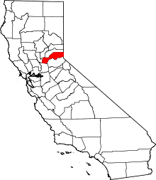
 Location in Placer County and the state of California | |
 North Auburn Location in the United States | |
| Coordinates: 38°56′2″N 121°5′2″W / 38.93389°N 121.08389°WCoordinates: 38°56′2″N 121°5′2″W / 38.93389°N 121.08389°W | |
| Country |
|
| State |
|
| County | Placer |
| Government | |
| • State Senate | Dave Cox (R) |
| • State Assembly | Ted Gaines (R) |
| • U. S. Congress | Doug LaMalfa (R) and Tom McClintock (R)[1] |
| Area[2] | |
| • Total | 7.801 sq mi (20.205 km2) |
| • Land | 7.798 sq mi (20.198 km2) |
| • Water | 0.003 sq mi (0.007 km2) 0.04% |
| Elevation | 1,470 ft (448 m) |
| Population (2000) | |
| • Total | 11,847 |
| • Density | 1,558.8/sq mi (598.3/km2) |
| Time zone | PST (UTC-8) |
| • Summer (DST) | PDT (UTC-7) |
| ZIP code | 95603 |
| Area code(s) | 530 |
| FIPS code | 06-51637 |
| GNIS feature ID | 1867045 |
North Auburn is a census-designated place (CDP) in Placer County, California, United States. It is part of the Sacramento–Arden-Arcade–Roseville Metropolitan Statistical Area. The population was 13,022 at the 2010 census, up from 11,847 at the 2000 census.
Geography
North Auburn is located at 38°56′2″N 121°5′2″W / 38.93389°N 121.08389°W (38.933881, -121.083769).[3]
According to the United States Census Bureau, the CDP has a total area of 7.8 square miles (20 km2), 99.96% of it land and 0.04% of it water.
Climate
According to the Köppen Climate Classification system, North Auburn has a warm-summer Mediterranean climate, abbreviated "Csa" on climate maps.[4]
Demographics
2010
The 2010 United States Census[5] reported that North Auburn had a population of 13,022. The population density was 1,669.3 people per square mile (644.5/km²). The racial makeup of North Auburn was 11,081 (85.1%) White, 115 (0.9%) African American, 172 (1.3%) Native American, 298 (2.3%) Asian, 13 (0.1%) Pacific Islander, 893 (6.9%) from other races, and 450 (3.5%) from two or more races. Hispanic or Latino of any race were 2,108 persons (16.2%).
The Census reported that 11,999 people (92.1% of the population) lived in households, 308 (2.4%) lived in non-institutionalized group quarters, and 715 (5.5%) were institutionalized.
There were 5,080 households, out of which 1,440 (28.3%) had children under the age of 18 living in them, 2,254 (44.4%) were opposite-sex married couples living together, 598 (11.8%) had a female householder with no husband present, 238 (4.7%) had a male householder with no wife present. There were 312 (6.1%) unmarried opposite-sex partnerships, and 24 (0.5%) same-sex married couples or partnerships. 1,657 households (32.6%) were made up of individuals and 978 (19.3%) had someone living alone who was 65 years of age or older. The average household size was 2.36. There were 3,090 families (60.8% of all households); the average family size was 2.97.
The population was spread out with 2,732 people (21.0%) under the age of 18, 1,125 people (8.6%) aged 18 to 24, 2,988 people (22.9%) aged 25 to 44, 3,535 people (27.1%) aged 45 to 64, and 2,642 people (20.3%) who were 65 years of age or older. The median age was 42.5 years. For every 100 females there were 93.2 males. For every 100 females age 18 and over, there were 92.7 males.
There were 5,539 housing units at an average density of 710.0 per square mile (274.1/km²), of which 3,092 (60.9%) were owner-occupied, and 1,988 (39.1%) were occupied by renters. The homeowner vacancy rate was 2.9%; the rental vacancy rate was 10.1%. 6,869 people (52.7% of the population) lived in owner-occupied housing units and 5,130 people (39.4%) lived in rental housing units.
2000
As of the census[6] of 2000, there were 11,847 people, 4,817 households, and 2,991 families residing in the CDP. The population density was 1,553.2 people per square mile (599.5/km²). There were 4,982 housing units at an average density of 653.2 per square mile (252.1/km²). The racial makeup of the CDP was 89.74% White, 0.71% African American, 1.17% Native American, 1.79% Asian, 0.09% Pacific Islander, 3.73% from other races, and 2.76% from two or more races. Hispanic or Latino of any race were 9.21% of the population.
There were 4,817 households out of which 28.0% had children under the age of 18 living with them, 45.3% were married couples living together, 12.7% had a female householder with no husband present, and 37.9% were non-families. 31.7% of all households were made up of individuals and 17.9% had someone living alone who was 65 years of age or older. The average household size was 2.32 and the average family size was 2.90.
In the CDP the population was spread out with 22.3% under the age of 18, 8.1% from 18 to 24, 25.7% from 25 to 44, 22.5% from 45 to 64, and 21.4% who were 65 years of age or older. The median age was 41 years. For every 100 females there were 90.4 males. For every 100 females age 18 and over, there were 86.9 males.
The median income for a household in the CDP was $37,493, and the median income for a family was $46,418. Males had a median income of $37,673 versus $26,789 for females. The per capita income for the CDP was $22,091. About 7.0% of families and 9.4% of the population were below the poverty line, including 14.7% of those under age 18 and 3.0% of those age 65 or over.
References
- ↑ "California's 4th Congressional District - Representatives & District Map". Civic Impulse, LLC. Retrieved March 3, 2013.
- ↑ "2010 Census U.S. Gazetteer Files – Places – California". United States Census Bureau.
- ↑ "US Gazetteer files: 2010, 2000, and 1990". United States Census Bureau. 2011-02-12. Retrieved 2011-04-23.
- ↑ Climate Summary for North Auburn, California
- ↑ "2010 Census Interactive Population Search: CA - North Auburn CDP". U.S. Census Bureau. Retrieved July 12, 2014.
- ↑ "American FactFinder". United States Census Bureau. Retrieved 2008-01-31.
External links
 |
Sheridan | Alta Sierra | Foresthill | |
| Rio Oso | |
Georgetown | ||
| ||||
| | ||||
| Lincoln | Auburn | Cool |