El Cajon, California
| El Cajon, California | ||
|---|---|---|
| City | ||
| City of El Cajon | ||
|
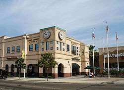
Office building on El Cajon's Main Street | ||
| ||
| Motto: "The Valley of Opportunity" | ||
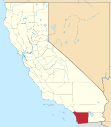
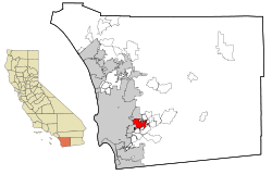 Location in San Diego County and the state of California | ||
 El Cajon, California Location in the United States | ||
| Coordinates: 32°47′54″N 116°57′36″W / 32.79833°N 116.96000°WCoordinates: 32°47′54″N 116°57′36″W / 32.79833°N 116.96000°W | ||
| Country |
| |
| State |
| |
| County | San Diego | |
| Incorporated | November 12, 1912[1] | |
| Government | ||
| • Mayor | Bill Wells[2] | |
| Area[3] | ||
| • Total | 14.433 sq mi (37.381 km2) | |
| • Land | 14.433 sq mi (37.381 km2) | |
| • Water | 0 sq mi (0 km2) 0% | |
| Elevation[4] | 433 ft (132 m) | |
| Population (April 1, 2010)[5] | ||
| • Total | 99,478 | |
| • Estimate (2014)[5] | 103,091 | |
| • Density | 6,900/sq mi (2,700/km2) | |
| Time zone | Pacific (UTC−8) | |
| • Summer (DST) | PDT (UTC−7) | |
| ZIP codes | 92019–92022, 92090 | |
| Area code | 619 | |
| FIPS code | 06-21712 | |
| GNIS feature IDs | 1652701, 2410406 | |
| Website |
www | |
El Cajon (/ɛlkəˈhoʊn/; Spanish: [elkaˈxon]) is a city in San Diego County, California, United States. In a valley surrounded by mountains, the city has acquired the nickname of "The Big Box."[6] Its name originated similarly, from the Spanish phrase "el cajón," which means "the box" or "the drawer."
Name
El Cajon, Spanish for "the big box," was first recorded on September 10, 1821, as an alternative name for sitio rancho Santa Mónica to describe the "boxed in" nature of the valley in which it sat. The name appeared on maps in 1873 and 1875, shortened to "Cajon," until the modern town developed in which the post office was named "Elcajon."
In 1905, the name was once again expanded to "El Cajon" under the insistence of California banker and historian, Zoeth Skinner Eldredge.[7]
Geography and climate
El Cajon is located at 32°47′54″N 116°57′36″W / 32.79833°N 116.96000°W (32.798300, -116.960055).[8] According to the United States Census Bureau, the city has a total area of 14.4 square miles (37 km2), all land. It is bordered by San Diego and La Mesa on the west, Spring Valley on the south, Santee on the north, and unincorporated San Diego County on the east. It includes the neighborhoods of Fletcher Hills, Bostonia, and Rancho San Diego.
Under the Köppen climate classification system, El Cajon straddles areas of Mediterranean climate (CSa) and semi-arid climate (BSh). As a result, it is often described as "arid Mediterranean" and "semi-arid Steppe". Like most inland areas in Southern California, the climate varies dramatically within a short distance, known as microclimate. El Cajon's climate has greater extremes compared to coastal San Diego. The farther east from the coast, the more arid the climate gets, until one reaches the mountains, where precipitation increases due to orographic uplift.[9][10]
El Cajon's climate is warm during summer with mean temperatures averaging 70.1 °F (21.2 °C) or higher and cool during winter with mean temperatures averaging 55.4 °F (13.0 °C) or higher.
The warmest month of the year is August with an average maximum temperature of 88.1 °F (31.2 °C), while the coldest month of the year is December with an average minimum temperature of 40.3 °F (4.6 °C).
Temperature variations between night and day tend to be moderate with an average difference of 24 °F (13 °C) during the summer, and an average difference of 26 °F (14 °C) during the winter.
The annual average precipitation at El Cajon is 11.96 inches (30.4 cm). Rainfall is fairly evenly distributed throughout the winter months, but rare in summer. The wettest month of the year is December with an average rainfall of 3.80 inches (9.7 cm).
The record high temperature was 113 °F (45 °C) on June 14, 1917; September 1, 1955; July 22, 2006; and September 27, 2010. The record low temperature was 19 °F (−7 °C) on January 8, 1913. The wettest year was 1941 with 28.14 inches (71.5 cm) and the dryest year was 1989 with 1.51 inches (3.8 cm). The most rainfall in one month was 11.43 inches (29.0 cm) in January 1993. The most rainfall in 24 hours was 5.60 inches (14.2 cm) on January 27, 1916. A rare snowfall in November 1992 totaled 0.3 inches (0.76 cm).[11] 3 inches of snow covered the ground in January 1882.
History
During Spanish rule (1769–1821), the government encouraged settlement of territory now known as California by the establishment of large land grants called ranchos, from which the English word ranch is derived. Land grants were made to the Roman Catholic Church which set up numerous missions throughout the region. In the early nineteenth century, mission padres' search for pasture land led them to the El Cajon Valley. Surrounding foothills served as a barrier to straying cattle and a watershed to gather the sparse rainfall. For years the pasture lands of El Cajon supported the cattle herds of the mission and its native Indian converts.
It was not until the Mexican era (1821–1846) that titles to plots of land were granted to individuals. The original intent of the 1834 secularization legislation was to have church property divided among the former mission Indians. However, most of the grants were actually made to rich "Californios" of Spanish background who had long been casting envious eyes on the vast holdings of the Roman Catholic missions. In 1845 California Governor Pio Pico confiscated the lands of Mission San Diego de Alcala. He granted eleven square leagues (about 48,800 acres, 197 km2) of the El Cajon Valley to Dona Maria Antonio Estudillo, daughter of José Antonio Estudillo, alcalde of San Diego, to repay a $500 government obligation. The grant was originally called Rancho Santa Monica and encompassed present day El Cajon, Bostonia, Santee, Lakeside, Flinn Springs, and the eastern part of La Mesa. It also contained the 28-acre (0.11 km2) Rancho Cañada de los Coches grant. Maria Estudillo was the wife of Don Miguel Pedrorena (1808–1850), a native of Madrid, Spain, who had come to California from Peru in 1838 to operate a trading business.
With the cession of California to the United States following the Mexican-American War, the 1848 Treaty of Guadalupe Hidalgo provided that the land grants would be honored. As required by the Land Act of 1851, a claim for Rancho El Cajon was filed by Thomas W. Sutherland, guardian of Pedrorena's heirs (his son, Miguel, and his three daughters, Victoria, Ysabel and Elenain) with the Public Land Commission in 1852, confirmed by the U.S. Supreme Court, and the grant was patented in 1876. In 1868, Los Angeles land developer Isaac Lankershim bought the bulk of the Pedrorena's Rancho El Cajon holdings and employed Major Levi Chase, a former Union Army officer, as his agent. Chase received from Lankershim 7,624 acres (30.9 km2) known as the Chase Ranch. Lankershim hired Amaziah Lord Knox (1833–1918), a New Englander whom he had met in San Francisco, to manage Rancho El Cajon. In 1876, Knox established a hotel there to serve the growing number of people traveling between San Diego and Julian, where gold had been discovered in 1869. Room and board for a guest and horse cost $1 a night. The area became known as Knox's Corners and was later renamed.[12][13] By 1878 there were 25 families living in the valley and a portion of the hotel lobby became the valley post office with Knox as the first postmaster.
El Cajon was incorporated as a city in 1912.[14]
In the 1960s and 70s, Frontier Town, Big Oak Ranch, was a tourist attraction, featuring a typical frontier town themepark and a periodic simulated shootout. The park closed around 1980 and is being used for residential housing.
Climate
| Climate data for El Cajon, California (1981–2010 normals) | |||||||||||||
|---|---|---|---|---|---|---|---|---|---|---|---|---|---|
| Month | Jan | Feb | Mar | Apr | May | Jun | Jul | Aug | Sep | Oct | Nov | Dec | Year |
| Record high °F (°C) | 92 (33) |
95 (35) |
98 (37) |
104 (40) |
104 (40) |
106 (41) |
113 (45) |
107 (42) |
110 (43) |
106 (41) |
99 (37) |
91 (33) |
113 (45) |
| Average high °F (°C) | 72.5 (22.5) |
70.5 (21.4) |
75.0 (23.9) |
79.0 (26.1) |
81.0 (27.2) |
85.5 (29.7) |
90.5 (32.5) |
89.5 (31.9) |
96.5 (35.8) |
84.0 (28.9) |
78.0 (25.6) |
69.5 (20.8) |
81.0 (27.2) |
| Average low °F (°C) | 41.0 (5) |
41.5 (5.3) |
45.5 (7.5) |
49.0 (9.4) |
53.5 (11.9) |
59.0 (15) |
63.0 (17.2) |
66.0 (18.9) |
61.0 (16.1) |
54.5 (12.5) |
46.0 (7.8) |
37.5 (3.1) |
51.5 (10.8) |
| Record low °F (°C) | 26 (−3) |
28 (−2) |
30 (−1) |
36 (2) |
31 (−1) |
46 (8) |
50 (10) |
50 (10) |
49 (9) |
40 (4) |
30 (−1) |
25 (−4) |
25 (−4) |
| Average precipitation inches (mm) | 2.09 (53.1) |
2.40 (61) |
2.11 (53.6) |
1.20 (30.5) |
0.77 (19.6) |
0.47 (11.9) |
0.70 (17.8) |
0.35 (8.9) |
0.75 (19) |
1.90 (48.3) |
2.40 (61) |
3.80 (96.5) |
18.94 (481.2) |
| Source: NOAA [15] | |||||||||||||
Demographics
| Historical population | |||
|---|---|---|---|
| Census | Pop. | %± | |
| 1920 | 469 | — | |
| 1930 | 1,050 | 123.9% | |
| 1940 | 1,471 | 40.1% | |
| 1950 | 5,600 | 280.7% | |
| 1960 | 37,618 | 571.8% | |
| 1970 | 52,273 | 39.0% | |
| 1980 | 73,892 | 41.4% | |
| 1990 | 88,693 | 20.0% | |
| 2000 | 94,869 | 7.0% | |
| 2010 | 99,478 | 4.9% | |
| Est. 2015 | 103,679 | [16] | 4.2% |
2010
The 2010 United States Census reported that El Cajon had a population of 99,478. The racial makeup of El Cajon was 68,897 (69.3%) White (56.8% non-Hispanic white), 6,306 (6.3%) African American, 835 (0.8%) Native American, 3,561 (3.6%) Asian (1.7% Filipino, 0.5% Chinese, 0.4% Vietnamese, 0.2% Japanese, 0.1% Indian, 0.1% Korean, 0.6% Other), 495 (0.5%) Pacific Islander, 12,552 (12.6%) from other races, and 6,832 (6.9%) from two or more races. Hispanic or Latino of any race were 28,036 persons (28.2%).[18]
El Cajon has a large Iraqi population, consisting of both Arabs and Assyrians both of which are some of the largest in the country.[19] According to the U.S. Census Bureau 2008-2010 Estimate, 7,537 residents are Arab (7.6%; mainly Iraqi), and 6,409 (6.4%) are Assyrian Americans.[18]
In 2010 El Cajon had San Diego County's highest poverty rate among adults, at 29.7%, and children, at 36.5%.[18]
2000
As of the census[20] of 2000, there were 94,869 people, 34,199 households, and 23,152 families residing in the city. The population density was 6,510.6 inhabitants per square mile (2,514.0/km²). There were 35,190 housing units at an average density of 2,415.0 per square mile (932.5/km²). The racial makeup of the city was 74.0% White, 5.4% African American, 1.0% Native American, 2.8% Asian, 0.4% Pacific Islander, 10.5% from other races, and 6.0% from two or more races. Hispanic or Latino of any race were 22.5% of the population.
There were 34,199 households out of which 37.0% had children under the age of 18 living with them, 46.0% were married couples living together, 16.0% had a female householder with no husband present, and 32.3% were non-families. 24.1% of all households were made up of individuals and 8.5% had someone living alone who was 65 years of age or older. The average household size was 2.70 and the average family size was 3.21.
In the city the population was spread out with 27.9% under the age of 18, 11.2% from 18 to 24, 31.3% from 25 to 44, 18.3% from 45 to 64, and 11.3% who were 65 years of age or older. The median age was 32 years. For every 100 females there were 95.2 males. For every 100 females age 18 and over, there were 91.4 males.
The median income for a household in the city was $35,566, and the median income for a family was $40,045. Males had a median income of $32,498 versus $25,320 for females. The per capita income for the city was $16,698. About 13.5% of families and 16.7% of the population were below the poverty line, including 23.1% of those under age 18 and 9.0% of those age 65 or over.
Current estimates
According to estimates by the San Diego Association of Governments, the median household income of El Cajon in 2005 was $47,885 (not adjusted for inflation). When adjusted for inflation (1999 dollars; comparable to Census data above), the median household income was $38,884.
Government
Until 2012 El Cajon was a general law city operating under a council-manager system. In June 2012 the voters adopted a city charter, changing its status to chartered city.[21] El Cajon is governed by a mayor and a five-member city council.[22]
On October 24, 2013, Mayor Mark Lewis resigned his position after coming under criticism for remarks he made about El Cajon's Chaldean community. Many notable figures including Congressman Juan Vargas and Neighborhood Market Association President Mark Arabo called for his resignation.[23] Lewis resigned shortly after due to health issues.[24] On November 12 the city council appointed Councilman Bill Wells, who had been serving as interim mayor, as the new mayor.The vote of the council was 4-0; Wells recused himself.[25] He was elected to a full four-year term as mayor in November 2014. His term will expire in November 2018.[26]
State and federal representation
In the California State Legislature, El Cajon is in the 38th Senate District, represented by Republican Joel Anderson, and in the 71st Assembly District, represented by Republican Randy Voepel.[27]
In the United States House of Representatives, El Cajon is split between California's 50th congressional district, represented by Republican Duncan D. Hunter, and California's 53rd congressional district, represented by Democrat Susan Davis.[28]
Economy
Parkway Plaza is located in El Cajon.
Top employers
According to the City's 2014 Comprehensive Annual Financial Report,[29] the top employers in the city are:
| # | Employer | # of Employees |
|---|---|---|
| 1 | Cajon Valley Union School District | 1,412 |
| 2 | GKN Aerospace Chem-tronics | 859 |
| 3 | Grossmont–Cuyamaca Community College District | 712 |
| 4 | City of El Cajon | 450 |
| 5 | Grossmont Union High School District | 431 |
| 6 | Taylor Guitars | 400 |
| 7 | Country Hills Health Care & Rehabilitation Center | 357 |
| 8 | University Mechanical & Engineering Contractors | 352 |
| 9 | The Home Depot | 339 |
| 10 | Walmart | 260 |
Schools
Cajon Valley Union School District operates public elementary and middle schools. Grossmont Union High School District operates public high schools.
Elementary schools
- Anza Elementary
- Avocado Elementary
- Blossom Valley Elementary
- Bostonia Elementary
- Chase Avenue Elementary
- Crest Elementary
- Dehesa School
- Fletcher Hills Elementary
- Flying Hills Elementary
- Fuerte Elementary
- Jamacha Elementary
- Johnson Elementary
- Lexington Elementary
- Madison Elementary
- Magnolia Elementary
- Meridian Elementary
- Naranca Elementary
- Rancho San Diego Elementary
- Rios Elementary
- Vista Grande Elementary
- W.D. Hall Elementary
Middle schools
- Cajon Valley Middle School
- Emerald Middle School
- Greenfield Middle School
- Hillsdale Middle School
- Los Coches Creek Middle School
- Montgomery Middle School
High schools
- Chaparral High School
- Christian High School
- El Cajon Valley High School
- Granite Hills High School
- Grossmont High School
- IDEA Center High School
- Valhalla High School
Colleges
- Advanced Training
- Cuyamaca College
- Grossmont College
- San Diego Christian College
- Seminary of Mar Abba the Great of the Chaldean Catholic Church
Places of interest
Companies
- Taylor Guitars
- Solid Gold
- Catholic Answers
- Scantibodies Biologics Inc.
Airports
Notable people
- Lester Bangs, Rolling Stone rock critic[30]
- William Bengen, certified financial planner who proposed the 4 percent draw-down rule in retirement planning
- Kurt Bevacqua, former Major League Baseball player
- Jolene Blalock, model, actress
- Aaron Boone, former Major League Baseball player
- Bob Boone, former Major League Baseball player
- Bret Boone, former Major League Baseball player
- Tony Clark, former Major League Baseball player
- Kevin Correia, current Major League Baseball player
- William John Cox (Billy Jack Cox), public interest attorney, author and political activist lived and served as a police officer in El Cajon between 1962 and 1968
- Dave Dravecky, former Major League Baseball player
- Amy Finley, host of The Gourmet Next Door on the Food Network Channel
- Geoff Geary, former Major League Baseball player
- Brian Giles, former Major League Baseball player
- Marcus Giles, former Major League Baseball player
- Broc Glover, professional motocross racer
- Brian Graham, former Minor League Baseball player
- Ryan Hansen, actor
- Mike Hartley, former Major League Baseball player
- David Jeremiah, Christian minister
- Jimmie Johnson, seven-time NASCAR Champion
- Ricky Johnson, motocross racer
- Joe Kennedy, former Major League Baseball player
- David Lee, volleyball Olympic gold medalist
- Greg Louganis, Olympic diver
- Mark Malone, former NFL football player and sportscaster
- Glen Morgan, film director
- Swen Nater, former NBA basketball player
- Grant Roberts, former Major League Baseball player
- Julia Schultz, former model and Playmate for Playboy magazine
- Brian Sipe, former NFL football player
- Shane Spencer, former Major League Baseball player
- Tommy Vardell, former NFL football player
- Brandon Whitt, current NASCAR driver
- Katie Wilkins, Team USA Olympic volleyball player
- James Wong, television producer
- Frank Zappa, musician[31]
- Barry Zito, former Major League Baseball player
See also
-
 San Diego County portal
References
- ↑ "California Cities by Incorporation Date" (Word). California Association of Local Agency Formation Commissions. Retrieved August 25, 2014.
- ↑ "City Council: Overview". City of El Cajon. Retrieved January 19, 2015.
- ↑ "El Cajon (city), California QuickFacts". U.S. Census. Retrieved September 25, 2013.
- ↑ "El Cajon". Geographic Names Information System. United States Geological Survey. Retrieved November 5, 2014.
- 1 2 "American FactFinder - Results". United States Census Bureau. Retrieved May 24, 2015.
- ↑ El Cajon city history
- ↑ Gudde, Erwin G. (2004). California place names : the origin and etymology of current geographical names (4th ed., rev. and enl. ed.). Berkeley, Calif.: University of California Press. pp. 58, 119. ISBN 978-0-520-24217-3.
- ↑ "US Gazetteer files: 2010, 2000, and 1990". United States Census Bureau. 2011-02-12. Retrieved 2011-04-23.
- ↑ http://www.teachmefinance.com/Scientific_Terms/Orographic_Uplift.html
- ↑ http://milhollandelectric.com/el-cajon-ca/#.U5TtwZRdWd4. Missing or empty
|title=(help) - ↑ El Cajon Monthly Climate Summary; El Cajon Yale Ranch Monthly Climate Summary. Western Regional Climate Center. Retrieved February 26, 2013.
- ↑ City of El Cajon, "The Downtown El Cajon Arch,", retrieved April 24, 2011; a copy is archived by WebCite® at http://www.webcitation.org/5yDCeVdCW
- ↑ City of El Cajon, text of plaque on the Memorial Arch at intersection of Main and Magnolia Streets, 2009.
- ↑ Hellmann, Paul T. (2005). Historical Gazetteer of the United States. Taylor & Francis. p. 86. ISBN 0-203-99700-X.
- ↑ "NOWData - NOAA Online Weather Data". National Oceanic and Atmospheric Administration. Retrieved 2012-12-02.
- ↑ "Annual Estimates of the Resident Population for Incorporated Places: April 1, 2010 to July 1, 2015". Retrieved July 2, 2016.
- ↑ "Census of Population and Housing". Census.gov. Retrieved June 4, 2015.
- 1 2 3 "2010 Census P.L. 94-171 Summary File Data". United States Census Bureau.
- ↑ El Cajon Sees Rise In Iraqi Refugee Population, ABC10 News, September 28, 2010.
- ↑ "American FactFinder". United States Census Bureau. Retrieved 2008-01-31.
- ↑ "Presidential Primary Election, Tuesday, June 5, 2012" (PDF). San Diego County Registrar of Voters. Retrieved October 26, 2013.
- ↑ "Elected officials". City of El Cajon. Retrieved October 26, 2013.
- ↑ Pearlman, Karen (November 13, 2013). "Council names Wells El Cajon's new mayor". San Diego Union Tribune. Retrieved 7 May 2014.
- ↑ Pearlman, Karen (October 24, 2013). "El Cajon Mayor Mark Lewis resigns". San Diego Union Tribune.
- ↑ Alford, Abbie (November 12, 2013). "El Cajon appoints mayor before packed crowd". CBS-8. Retrieved November 13, 2013.
- ↑ El Cajon City Council
- ↑ "Statewide Database". UC Regents. Retrieved November 28, 2014.
- ↑ "Communities of Interest - City". California Citizens Redistricting Commission. Retrieved September 27, 2014.
- ↑ City of El Cajon CAFR
- ↑ Robert Christgau: Lester Bangs, 1948-1982
- ↑ Zwerin, Mike (1993-12-08). "Zappa's Talent for Fun". The New York Times. ISSN 0362-4331. Retrieved 2016-02-28.
External links
| Wikimedia Commons has media related to El Cajon, California. |
| Counties | ||
|---|---|---|
| Major city | ||
| Cities 100k - 250k | ||
| Cities and towns 20k - 99k | ||
| CDPs 20k+ | ||
| Bodies of water | ||
| Regions | ||
| Parks and Monuments | ||
| |
^* Mayor selected from city council
|