Death Valley
| Death Valley | |
|---|---|
|
Death Valley | |
 Death Valley California | |
| Floor elevation | −85 m (−279 ft)[1] |
| Area | 3,000 square miles |
| Geography | |
| Coordinates | 36°14′49″N 116°49′01″W / 36.24694°N 116.81694°WCoordinates: 36°14′49″N 116°49′01″W / 36.24694°N 116.81694°W[2] |
| Watercourses |
Furnace Creek Amargosa River |
Death Valley is a desert valley located in Eastern California. It is one of the hottest places in the world at the height of summertime along with other deserts in Africa and in the Middle East.[3]
Death Valley's Badwater Basin is the point of the lowest elevation in North America, at 282 feet (86 m) below sea level.[1] This point is 84.6 miles (136.2 km) east-southeast of Mount Whitney, the highest point in the contiguous United States with an elevation of 14,505 feet (4,421 m).[4] Death Valley's Furnace Creek holds the record for the highest reliably recorded air temperature in the world, 134 °F (56.7 °C) on July 10, 1913.[5] This has been contested by other weather experts.[6]
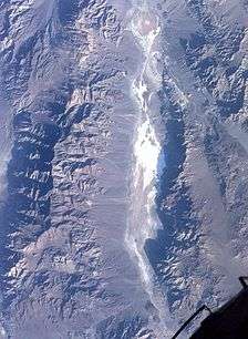
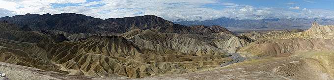
Located near the border of California and Nevada, in the Great Basin, east of the Sierra Nevada mountains, Death Valley constitutes much of Death Valley National Park and is the principal feature of the Mojave and Colorado Deserts Biosphere Reserve. It is located mostly in Inyo County, California. It runs from north to south between the Amargosa Range on the east and the Panamint Range on the west; the Sylvania Mountains and the Owlshead Mountains form its northern and southern boundaries, respectively. It has an area of about 3,000 sq mi (7,800 km2).[7] The highest point in Death Valley itself is Telescope Peak in the Panamint Range, which has an elevation of 11,043 feet (3,366 m).
Geology

Death Valley is one of the best geological examples of a basin and range configuration. It lies at the southern end of a geological trough known as Walker Lane, which runs north into Oregon. The valley is bisected by a right lateral strike slip fault system, represented by the Death Valley Fault and the Furnace Creek Fault. The eastern end of the left lateral Garlock Fault intersects the Death Valley Fault. Furnace Creek and the Amargosa River flow through the valley but eventually disappear into the sands of the valley floor.
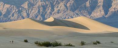
Death Valley also contains salt pans. According to current geological consensus, at various times during the middle of the Pleistocene era, inland lakes (collectively referred to as Lake Manly) formed in Death Valley. Lake Manly received water overflowing from a chain of other Pleistocene lakes, most of which are now also dry lakebeds. As the area turned to desert, the water evaporated, leaving the abundance of evaporitic salts such as common sodium salts and borax, which were later exploited during the modern history of the region, primarily 1883 to 1907.[8]
Climate
Death Valley has a subtropical, hot desert climate (Köppen: BWh), with long, extremely hot summers and short, warm or mild winters, as well as little rainfall. As a general rule, lower altitudes tend to have higher temperatures. When the sun heats the ground, that heat is then radiated upward, but the dense below-sea-level air acts as a blanket and reflects the heat back. In addition, the high valley walls trap rising hot air and recycle it back down to the valley floor, where it is heated by compression.[9]
This process is especially important in Death Valley, as it provides its specific climate and geography. The valley is surrounded by mountains, while its surface is mostly flat and devoid of plants, so much of the sun's heat can reach the ground, absorbed by soil and rock. When air at ground level is heated, it begins to rise, moving up past steep, high mountain ranges, which then cools slightly, sinking back down towards the valley more compressed. This air is then reheated by the sun to a higher temperature, moving up the mountain again, whereby the air moves up and down in a circular motion in cycles, similar to how a convection oven works. This heated air increases ground temperature markedly, forming the hot wind currents that are trapped by atmospheric pressure and mountains, thus stays mostly within the valley. Such hot wind currents contribute to perpetual drought-like conditions in Death Valley and prevent much cloud formation from passing through the confines of the valley, where precipitation is often in the form of a virga.[10] Death Valley holds temperature records because it has an unusually high number of factors that lead to high atmospheric temperatures.
The depth and shape of Death Valley influence its summer temperatures. The valley is a long, narrow basin 282 feet (86 m) below sea level, yet is walled by high, steep mountain ranges. The clear, dry air and sparse plant cover allow sunlight to heat the desert surface. Summer nights provide little relief, as overnight lows may only dip into the 82 to 98 °F (28 to 37 °C) range. Moving masses of super-heated air blow through the valley creating extremely high temperatures.[11]
The hottest air temperature ever recorded in Death Valley was 134 °F (56.7 °C) on July 10, 1913, at Furnace Creek,[12] which is the hottest atmospheric temperature ever recorded on earth.[5] During the heat wave that peaked with that record, five consecutive days reached 129 °F (54 °C) or above. Some meteorologists dispute the accuracy of the 1913 temperature measurement.[13]
The greatest number of consecutive days with a maximum temperature of 100 °F (38 °C) or above was 154 days in the summer of 2001. The summer of 1996 had 40 days over 120 °F (49 °C), and 105 days over 110 °F (43 °C). The summer of 1917 had 52 days where the temperature reached 120 °F (49 °C) or above with 43 of them consecutive. Four major mountain ranges lie between Death Valley and the ocean, each one adding to an increasingly drier rain shadow effect, and in 1929, 1953, and 1989, no rain was recorded for the whole year.[11] The period from 1931 to 1934 was the driest stretch on record with only 0.64 inches (16 mm) of rain over a 40-month period.[10] On June 30, 2013, during the 2013 extreme heat wave, the mercury reached 129 °F (54 °C) at Furnace Creek station, which is the all-time hottest air temperature recorded for June.
The mean annual temperature for Death Valley (Furnace Creek Weather Station) is 77.2 °F (25.1 °C) with an average high in January around 67 °F (19 °C) and 116 °F (47 °C) in July.[14] From 1934-1961, the weather station at Cow Creek recorded a mean annual temperature of 77.2 °F (25.1 °C).[15]
The longest number of consecutive days where temperatures reached 90 °F (32 °C) or more was 205 from April to October 1992.[16] On average, 192 days per year in Death Valley have temperatures that reach 90 °F or more.[17] Before being moved to Furnace Creek, the weather station at Greenland Ranch averaged 194.4 days annually where temperatures reached 90 °F or more.[18]

On July 12, 2012, the day's low temperature was 107 °F (42 °C), tying the record for the world's hottest low temperature ever recorded.[19] On the same day, the average temperature was 117.5 °F (47.5 °C), which is the world's hottest temperature averaged over 24 hours on record.[19]
The lowest temperature recorded at Greenland Ranch was 15 °F (−9 °C) in January 1913.[20]
The period from July 17–19, 1959, was the longest string of consecutive days where nighttime low temperatures did not drop below 100 °F (38 °C).[21] The highest overnight or low temperature recorded in Death Valley is 110 °F (43 °C), recorded on July 5, 1918, and the current world record for hottest overnight low.[22] As recently as July 12, 2012, the low temperature at Death Valley dropped to just 107 °F (42 °C) after a high of 128 °F (53 °C) on the previous day. The only other location which matches Death Valley's overnight low temperature of 107 °F in recent years is Khasab Airport in Oman, which also recorded a low of 107 °F (42 °C) on June 27, 2012. Also on July 12, 2012 the mean 24-hour temperature recorded at Death Valley was 117.5 °F (47.5 °C), which makes it the world's warmest 24-hour temperature on record.[23]
The average annual precipitation in Death Valley is 2.36 inches (60 mm), while the Greenland Ranch station averaged 1.58 in (40 mm).[24] The wettest month on record is January 1995, when 2.59 inches (66 mm) fell on Death Valley.[10] The wettest period on record was mid-2004 to mid-2005, in which nearly 6 inches (150 mm) of rain fell in total, leading to ephemeral lakes in the valley and the region and tremendous wildflower blooms.[25] Snow with accumulation has only been recorded in January 1922, while scattered flakes have been recorded on other occasions.
| Climate data for Death Valley (Furnace Creek Station) | |||||||||||||
|---|---|---|---|---|---|---|---|---|---|---|---|---|---|
| Month | Jan | Feb | Mar | Apr | May | Jun | Jul | Aug | Sep | Oct | Nov | Dec | Year |
| Record high °F (°C) | 87 (31) |
97 (36) |
102 (39) |
113 (45) |
122 (50) |
129 (54) |
134 (57) |
127 (53) |
123 (51) |
113 (45) |
98 (37) |
89 (32) |
134 (57) |
| Mean maximum °F (°C) | 77.0 (25) |
83.9 (28.8) |
93.4 (34.1) |
103.4 (39.7) |
112.1 (44.5) |
120.4 (49.1) |
123.7 (50.9) |
121.9 (49.9) |
116.0 (46.7) |
104.2 (40.1) |
88.8 (31.6) |
77.0 (25) |
124.5 (51.4) |
| Average high °F (°C) | 66.9 (19.4) |
73.3 (22.9) |
82.1 (27.8) |
90.5 (32.5) |
100.5 (38.1) |
109.9 (43.3) |
116.5 (46.9) |
114.7 (45.9) |
106.5 (41.4) |
92.8 (33.8) |
77.1 (25.1) |
65.2 (18.4) |
91.4 (33) |
| Daily mean °F (°C) | 53.4 (11.9) |
59.8 (15.4) |
68.4 (20.2) |
76.3 (24.6) |
86.6 (30.3) |
95.5 (35.3) |
102.2 (39) |
100.2 (37.9) |
91.1 (32.8) |
77.1 (25.1) |
62.6 (17) |
51.7 (10.9) |
77.2 (25.1) |
| Average low °F (°C) | 40.0 (4.4) |
46.3 (7.9) |
54.8 (12.7) |
62.1 (16.7) |
72.7 (22.6) |
81.2 (27.3) |
88.0 (31.1) |
85.7 (29.8) |
75.6 (24.2) |
61.5 (16.4) |
48.1 (8.9) |
38.3 (3.5) |
62.9 (17.2) |
| Mean minimum °F (°C) | 28.4 (−2) |
34.4 (1.3) |
41.4 (5.2) |
48.7 (9.3) |
56.6 (13.7) |
65.4 (18.6) |
75.7 (24.3) |
73.5 (23.1) |
62.7 (17.1) |
48.8 (9.3) |
35.5 (1.9) |
28.8 (−1.8) |
26.3 (−3.2) |
| Record low °F (°C) | 15 (−9) |
20 (−7) |
26 (−3) |
35 (2) |
42 (6) |
49 (9) |
62 (17) |
65 (18) |
41 (5) |
32 (0) |
24 (−4) |
19 (−7) |
15 (−9) |
| Average precipitation inches (mm) | 0.39 (9.9) |
0.51 (13) |
0.30 (7.6) |
0.12 (3) |
0.03 (0.8) |
0.05 (1.3) |
0.07 (1.8) |
0.13 (3.3) |
0.21 (5.3) |
0.07 (1.8) |
0.18 (4.6) |
0.30 (7.6) |
2.36 (59.9) |
| Mean monthly sunshine hours | 217 | 226 | 279 | 330 | 372 | 390 | 403 | 372 | 330 | 310 | 210 | 186 | 3,625 |
| Source #1: NOAA 1981–2010 US Climate Normals[26] | |||||||||||||
| Source #2: weather2travel | |||||||||||||
| Climate data for Death Valley (Cow Creek Station) | |||||||||||||
|---|---|---|---|---|---|---|---|---|---|---|---|---|---|
| Month | Jan | Feb | Mar | Apr | May | Jun | Jul | Aug | Sep | Oct | Nov | Dec | Year |
| Record high °F (°C) | 84 (29) |
89 (32) |
100 (38) |
110 (43) |
120 (49) |
125 (52) |
126 (52) |
125 (52) |
123 (51) |
111 (44) |
95 (35) |
84 (29) |
126 (52) |
| Average high °F (°C) | 64.4 (18) |
71.6 (22) |
80.6 (27) |
90.9 (32.7) |
100.0 (37.8) |
109.3 (42.9) |
116.0 (46.7) |
113.8 (45.4) |
106.9 (41.6) |
92.1 (33.4) |
75.4 (24.1) |
65.9 (18.8) |
90.6 (32.6) |
| Daily mean °F (°C) | 52.5 (11.4) |
59.1 (15.1) |
67.4 (19.7) |
77.5 (25.3) |
86.4 (30.2) |
95.3 (35.2) |
102.1 (38.9) |
99.9 (37.7) |
92.1 (33.4) |
78.1 (25.6) |
62.3 (16.8) |
54.1 (12.3) |
77.2 (25.1) |
| Average low °F (°C) | 40.6 (4.8) |
46.6 (8.1) |
54.3 (12.4) |
64.1 (17.8) |
72.7 (22.6) |
81.2 (27.3) |
88.4 (31.3) |
86.0 (30) |
77.4 (25.2) |
64.0 (17.8) |
49.3 (9.6) |
42.4 (5.8) |
63.9 (17.7) |
| Record low °F (°C) | 19 (−7) |
30 (−1) |
33 (1) |
45 (7) |
52 (11) |
54 (12) |
69 (21) |
69 (21) |
57 (14) |
40 (4) |
32 (0) |
27 (−3) |
19 (−7) |
| Average precipitation inches (mm) | 0.24 (6.1) |
0.32 (8.1) |
0.20 (5.1) |
0.20 (5.1) |
0.10 (2.5) |
0.02 (0.5) |
0.10 (2.5) |
0.11 (2.8) |
0.12 (3) |
0.11 (2.8) |
0.20 (5.1) |
0.29 (7.4) |
2.00 (50.8) |
| Source: www | |||||||||||||
Biota

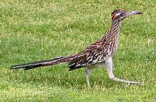
In spite of the overwhelming heat and sparse rainfall, Death Valley exhibits considerable biodiversity. Wildflowers, watered by snowmelt, carpet the desert floor each spring, continuing into June.[25] Bighorn sheep, red-tailed hawks, and wild burros may be seen. Death Valley has over 600 springs and ponds. Salt Creek, a mile-long shallow depression in the center of the valley, supports pupfish.[29]
Darwin Falls, on the western edge of Death Valley Monument, falls 100 feet (30 m) into a large pond surrounded by willows and cottonwood trees. Over 80 species of birds have been spotted around the pond.[30]
Lake Badwater and Glacial Lake Manly
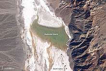
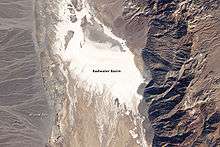
In 2005, Death Valley received four times its average annual rainfall of 1.5 inches (38 mm). As it has done before for hundreds of years, the lowest spot in the valley filled with a wide, shallow lake, but the extreme heat and aridity immediately began sucking the ephemeral lake dry.
This pair of images from NASA's Landsat 5 satellite documents the short history of Death Valley's Lake Badwater: formed in February 2005 (top) and long gone by February 2007 (bottom). In 2005, a big pool of greenish water stretched most of the way across the valley floor. By May 2005 the valley floor had resumed its more familiar role as Badwater Basin, a salt-coated salt flats. In time, this freshly dissolved and recrystallized salt will darken.
The western margin of Death Valley is traced by alluvial fans. During flash floods, rainfall from the steep mountains to the west pours through narrow canyons, picking up everything from fine clay to large rocks. When these torrents reach the mouths of the canyons, they widen and slow, branching out into braided streams. The paler the fans, the younger they are.

During the Pleistocene ice age, which ended roughly 10,000–12,000 years ago, the Sierra Nevada was much wetter. During that time, Death Valley was filled with a huge lake, called Glacial Lake Manly, that was nearly 100 miles (160 km) long and 600 feet (180 m) deep, the end-basin in a chain of lakes that began with Mono Lake in the north and continued through multiple basins down the Owens River Valley through Searles and China Lakes and the Panamint Valley to the immediate west.[31] Remnants of this wetter period can still be seen in the region today, including the presence of several isolated populations of pupfish.[29]
History
Death Valley is home to the Timbisha tribe of Native Americans, formerly known as the Panamint Shoshone, who have inhabited the valley for at least the past millennium. The Timbisha name for the valley, tümpisa, means "rock paint" and refers to the red ochre paint that can be made from a type of clay found in the valley. Some families still live in the valley at Furnace Creek. Another village was in Grapevine Canyon near the present site of Scotty's Castle. It was called in the Timbisha language maahunu, whose meaning is uncertain, although it is known that hunu means "canyon".
The valley received its English name in 1849 during the California Gold Rush. It was called Death Valley by prospectors[32] and others who sought to cross the valley on their way to the gold fields, after 13 pioneers perished from one early expedition of wagon trains.[33] During the 1850s, gold and silver were extracted in the valley. In the 1880s, borax was discovered and extracted by mule-drawn wagons.
On the afternoon of July 10, 1913, the United States Weather Bureau recorded a high temperature of 134 °F (56.7 °C) at Greenland Ranch (now Furnace Creek) in Death Valley.[5] This temperature stands as the highest ambient air temperature ever recorded at the surface of the Earth. (A report of a temperature of 58 °C (136.4 °F) recorded in Libya in 1922 was later determined to be inaccurate.)[12]
Death Valley National Monument was proclaimed on February 11, 1933, by President Herbert Hoover, placing the area under federal protection. In 1994, the monument was redesignated as Death Valley National Park, as well as being substantially expanded to include Saline and Eureka Valleys.
Notable locations

- Badwater Basin
- China Ranch
- Dante's View
- Darwin Falls
- Father Crowley Viewpoint
- Furnace Creek
- Furnace Creek Inn and Ranch Resort
- Harmony Borax Works
- Hells Gate
- Hog Ranch Mountains
- Myers Ranch
- Russell Camp
- New Ryan
- Upper and Lower Noonday Camp
- Shoreline Butte
- Stovepipe Wells
- Tecopa
- Tecopa Hot Springs
- West Side Borax Camp
- Wilson Ranch
- Wildrose Ranger Station
See also
- Racetrack Playa, a large dry lakebed within the Valley
- Sailing stones, famous moving stones of Death Valley
- Death Valley Suite, a symphonic suite by Ferde Grofe, inspired by the history and geography of Death Valley
References
- 1 2 "USGS National Elevation Dataset (NED) 1 meter Downloadable Data Collection from The National Map 3D Elevation Program (3DEP) - National Geospatial Data Asset (NGDA) National Elevation Data Set (NED)". United States Geological Survey. September 21, 2015. Retrieved September 22, 2015.
- ↑ "Feature Detail Report for: Death Valley". Geographic Names Information System. United States Geological Survey.
- ↑ "World Heat Record Overturned--A Personal Account". WunderBlog. Retrieved 24 October 2016.
Consequently, the WMO assessment is that the official highest recorded surface temperature of 56.7°C (134°F) was measured on 10 July 1913 at Greenland Ranch (Death Valley) CA USA.
- ↑ "Find Distance and Azimuths Between 2 Sets of Coordinates". Federal Communications Commission. Retrieved 13 August 2010.
Entered coordinates for Badwater 36-15-01-N, 116-49-33-W; and Mount Whitney 36-34-43-N, 118-17-31-W
- 1 2 3 "World Meteorological Organization World Weather / Climate Extremes Archive". Retrieved 10 January 2013.
- ↑ http://www.kpbs.org/news/2013/jul/15/doubts-cloud-death-valleys-100-year-heat-record/
- ↑ Wright, JW, ed. (2006). The New York Times Almanac (2007 ed.). New York, New York: Penguin Books. p. 456. ISBN 0-14-303820-6.
- ↑ Celeste Cosby; Jeanette Hawkins; Jani Kushla; Molly Robinson (2009). "Boron Minerals of Death Valley". Clark Science Center, Smith College. Archived from the original on 17 March 2008.
- ↑ "Weather and Climate Death Valley National Park" (PDF). U.S. National Park Service. July 2007. Retrieved 16 April 2009.
- 1 2 3 "Weather and Climate". Death Valley National Park. U.S. National Park Service. 23 May 2008. Retrieved 16 April 2009.
- 1 2 National Park Service. "Weather and Climate" (PDF). Death Valley. NPS.gov. Retrieved 29 May 2009.
- 1 2 El Fadli, KI; et al. (September 2012). "World Meteorological Organization Assessment of the Purported World Record 58°C Temperature Extreme at El Azizia, Libya (13 September 1922)". Bulletin of the American Meteorological Society. 94 (2): 199. doi:10.1175/BAMS-D-12-00093.1.
- ↑ Masters, Jeff. "Historic Heat Wave Reponsible(sic) for Death Valley's 129°F Gradually Weakening". WunderBlog. Wunderground.
- ↑ WRCC. "Western U.S. Climate Historical Summaries Weather". Desert Research Institute. Retrieved 29 May 2009.
- ↑ WRCC. "Western U.S. Climate Historical Summaries Weather". Desert Research Institute. Retrieved 17 September 2010.
- ↑ WRCC. "State Extremes". Desert Research Institute. Retrieved 8 June 2009.
- ↑ WRCC. "Temperature". General Climate Summary. Desert Research Institute. Retrieved 8 June 2009.
- ↑ WRCC. "Temperature". General Climate Summary. Desert Research Institute. Retrieved 6 March 2014.
- 1 2 Masters, Jeff (16 July 2013). "Death Valley records a low of 107°F (41.7°C): a world record". Weather Underground. Archived from the original on 27 June 2013.
- ↑ WRCC. "Period of Record General Climate Summary - Temperature". Greenland Ranch, California. Desert Research Institute. Retrieved 17 June 2011.
- ↑ Parzybok, TW (2005). Weather Extremes of the West. Missoula, Montana: Mountain Press Publishing Company. p. 103. ISBN 978-0878424733.
- ↑ http://www.wrh.noaa.gov/vef/climate/DeathValleyClimateBook/July%20Normal%20and%20Record%20Temperatures.pdf
- ↑ Jeff Masters. "Death Valley records a low of 107°F (41.7°C): a world record". Blog. Weather Underground. Retrieved 19 September 2012.
- ↑ WRCC. "Monthly Climate Summary". Desert Research Institute. Retrieved 8 June 2009.
- 1 2 NPR.org
- ↑ NOAA. "1981–2010 US Climate Normals". NOAA. Retrieved 25 July 2011.
- ↑ Weather2travel.com. "Weather2travel Death Valley Climate". Retrieved 16 June 2011.
- ↑ WRCC. "Western U.S. Climate Historical Summaries Weather". Desert Research Institute. Retrieved 3 June 2009.
- 1 2 Phenotypic Plasticity of Death Valley's Pupfish
- ↑ Not So Dead, Smithsonian Magazine, May 2008, p. 30
- ↑ "Image of the Day: Lake Badwater, Death Valley". Earth Observing System. NASA. 18 March 2009. Retrieved 16 April 2009.
- ↑ Lingenfelter, Richard E.; Dwyer, Richard A. (1988). Death Valley Lore, Classic Tales of Fantasy, Adventure and Mystery. Reno: University of Nevada Press. ISBN 0-87417-136-9.
- ↑ Manly, William Lewis (1894). "Death Valley in '49". Project Gutenberg. The Pacific Tree and Vine Co.
External links
| Wikimedia Commons has media related to: |
-
 Death Valley travel guide from Wikivoyage
 - National Park Service: Official Death Valley National Park website
- Historical photographs of Death Valley (1926), The Bancroft Library
- UNESCO Biosphere Preserve: Mojave and Colorado Deserts
- Strange moving rocks of the valley
- The Phenotypic Plasticity of Death Valley's Pupfishes an American Scientist article by Sean Lema
- Death Valley Area Interactive Map
- Surficial Geologic Map of the Death Valley Junction 30' x 60' Quadrangle, California and Nevada United States Geological Survey
- Death Valley Weather
- U.S. Geological Survey Geographic Names Information System: Death Valley
- Death Valley Nonprofit Support Organization
- Death Valley on National Geographic
