Placer County, California
| Placer County, California | |||||
|---|---|---|---|---|---|
| County | |||||
| County of Placer | |||||
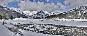
Images, from top down, left to right: The Auburn Courthouse, a view of Colfax, May snow in Squaw Valley | |||||
| |||||
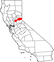 Location in the state of California | |||||
 The location of California in the United States | |||||
| Coordinates: 39°04′N 120°44′W / 39.06°N 120.73°WCoordinates: 39°04′N 120°44′W / 39.06°N 120.73°W | |||||
| Country |
| ||||
| State |
| ||||
| Regions | Sacramento Valley, Sierra Nevada | ||||
| CSA | Greater Sacramento | ||||
| Incorporated | April 25, 1851[1] | ||||
| Named for | Placer mining | ||||
| County seat | Auburn | ||||
| Largest city | Roseville (population and area) | ||||
| Area | |||||
| • Total | 1,502 sq mi (3,890 km2) | ||||
| • Land | 1,407 sq mi (3,640 km2) | ||||
| • Water | 95 sq mi (250 km2) | ||||
| Highest elevation[2] | 9,044 ft (2,757 m) | ||||
| Population (April 1, 2010)[3] | |||||
| • Total | 348,432 | ||||
| • Estimate (2015)[3] | 375,391 | ||||
| • Density | 230/sq mi (90/km2) | ||||
| Time zone | Pacific Time Zone (UTC-8) | ||||
| • Summer (DST) | Pacific Daylight Time (UTC-7) | ||||
| Area codes | 530, 916 | ||||
| FIPS code | 06-061 | ||||
| GNIS feature ID | 277295 | ||||
| Website |
www | ||||


Placer County (/ˈplæsər/ PLAS-ər), officially the County of Placer, is a county located in the U.S. state of California. As of the 2010 census, the population was 348,432.[3] The county seat is Auburn.[4]
Placer County is included in the Sacramento-Roseville-Arden-Arcade, CA Metropolitan Statistical Area. It is located in both the Sacramento Valley and Sierra Nevada regions, in what is known as the Gold Country. It stretches from the suburbs of Sacramento to Lake Tahoe and the Nevada border.
Etymology
The discovery of gold in 1848 brought tens of thousands of miners from around the world, in addition to many more thousands intending to provide goods and services to the miners. Only three years after the discovery of gold, the fast-growing county was formed from portions of Sutter and Yuba counties on April 25, 1851 with Auburn as the county seat. Placer County took its name from the Spanish word for sand or gravel deposits containing gold. Miners washed away the gravel, leaving the heavier gold, in a process known as "placer mining".
History
Gold mining was a major industry through the 1880s, but gradually the new residents turned to farming the fertile foothill soil, harvesting timber and working for the Southern Pacific Railroad. Auburn was settled when Claude Chana discovered gold in Auburn Ravine in May 1848 and later became a shipping and supply center for the surrounding gold camps. The cornerstone of Placer's beautiful and historic courthouse, which is clearly visible from Interstate 80 through Auburn, was laid on July 4, 1894. The building itself was renovated during the late 1980s and continues to serve the public today with courtrooms, a historic sheriff's office and the Placer County Museum. Roseville, once a small agricultural center, became a major railroad center and grew to the county's most populous city after Southern Pacific Railroad moved its railroad switching yards there in 1908.
Loomis and Newcastle began as mining towns, but soon became centers of a booming fruit-growing industry, supporting many local packing houses. Penryn was founded by a Welsh miner, Griffith Griffith, who turned from mining to establish a large granite quarry. Rocklin began as a railroad town and became home to a number of granite quarries. Lincoln and Sheridan continue to support ranching and farming. Lincoln also is the home of one of the county's oldest businesses, the Gladding, McBean terra cotta clay manufacturing plant established in 1875.
The 1960 Winter Olympics were hosted in Squaw Valley, which is located in Placer County.
Geography
According to the U.S. Census Bureau, the county has a total area of 1,502 square miles (3,890 km2), of which 1,407 square miles (3,640 km2) is land and 95 square miles (250 km2) (6.4%) is water.[5] Watercourses in Placer County include the American River and Bunch Creek. Lake Tahoe has 40.96% of its surface area in Placer County, more than in any of the four other counties in which it lies.[6]
National protected areas
- El Dorado National Forest in part
- Tahoe National Forest in part
Demographics
2011
| Population, race, and income | |||||
|---|---|---|---|---|---|
| Total population[7] | 343,554 | ||||
| White[7] | 290,923 | 84.7% | |||
| Black or African American[7] | 4,587 | 1.3% | |||
| American Indian or Alaska Native[7] | 2,654 | 0.8% | |||
| Asian[7] | 20,515 | 6.0% | |||
| Native Hawaiian or other Pacific Islander[7] | 750 | 0.2% | |||
| Some other race[7] | 11,478 | 3.3% | |||
| Two or more races[7] | 12,647 | 3.7% | |||
| Hispanic or Latino (of any race)[8] | 43,268 | 12.6% | |||
| Per capita income[9] | $35,583 | ||||
| Median household income[10] | $74,645 | ||||
| Median family income[11] | $90,446 | ||||
Places by population, race, and income
| Places by population and race | ||||||||
|---|---|---|---|---|---|---|---|---|
| Place | Type[12] | Population[7] | White[7] | Other[7] [note 1] |
Asian[7] | Black or African American[7] |
Native American[7] [note 2] |
Hispanic or Latino (of any race)[8] |
| Alta | CDP | 549 | 97.6% | 2.0% | 0.0% | 0.0% | 0.4% | 9.8% |
| Auburn | City | 13,476 | 90.4% | 6.7% | 1.2% | 1.0% | 0.7% | 6.6% |
| Carnelian Bay | CDP | 289 | 100.0% | 0.0% | 0.0% | 0.0% | 0.0% | 0.0% |
| Colfax | City | 1,999 | 92.1% | 5.0% | 2.7% | 0.1% | 0.2% | 4.1% |
| Dollar Point | CDP | 1,091 | 98.4% | 1.6% | 0.0% | 0.1% | 0.0% | 8.9% |
| Dutch Flat | CDP | 114 | 100.0% | 0.0% | 0.0% | 0.0% | 0.0% | 3.5% |
| Foresthill | CDP | 1,823 | 84.5% | 7.2% | 2.1% | 0.0% | 6.1% | 0.6% |
| Granite Bay | CDP | 22,201 | 88.0% | 5.3% | 5.2% | 0.4% | 1.2% | 5.3% |
| Kings Beach | CDP | 3,136 | 95.7% | 2.8% | 0.0% | 0.3% | 1.2% | 61.3% |
| Kingvale ‡ | CDP | 0 | 0.0% | 0.0% | 0.0% | 0.0% | 0.0% | 0.0% |
| Lincoln | City | 40,177 | 79.0% | 11.6% | 6.2% | 2.2% | 1.0% | 18.7% |
| Loomis | Town | 6,511 | 92.2% | 3.1% | 3.7% | 0.8% | 0.2% | 3.1% |
| Meadow Vista | CDP | 3,095 | 92.5% | 2.9% | 1.5% | 0.0% | 3.0% | 2.7% |
| Newcastle | CDP | 1,166 | 87.7% | 7.5% | 0.0% | 0.0% | 4.9% | 10.5% |
| North Auburn | CDP | 13,184 | 83.0% | 10.2% | 4.9% | 1.1% | 0.8% | 16.2% |
| Penryn | CDP | 665 | 99.1% | 0.0% | 0.9% | 0.0% | 0.0% | 0.0% |
| Rocklin | City | 55,713 | 83.1% | 6.0% | 8.2% | 1.7% | 1.1% | 10.5% |
| Roseville | City | 116,613 | 81.4% | 7.7% | 8.4% | 1.7% | 0.8% | 15.1% |
| Sheridan | CDP | 1,444 | 85.9% | 6.8% | 0.0% | 0.0% | 7.3% | 13.8% |
| Sunnyside-Tahoe City | CDP | 1,667 | 95.4% | 2.8% | 0.0% | 1.7% | 0.0% | 15.6% |
| Tahoe Vista | CDP | 1,376 | 86.4% | 9.4% | 4.1% | 0.0% | 0.0% | 42.5% |
| Tahoma ‡ | CDP | 361 | 100.0% | 0.0% | 0.0% | 0.0% | 0.0% | 10.2% |
| ‡ Data for Placer County area of this CDP | ||||||||
| Places by population and income | |||||
|---|---|---|---|---|---|
| Place | Type[12] | Population[13] | Per capita income[9] | Median household income[10] | Median family income[11] |
| Alta | CDP | 549 | $27,408 | $56,250 | $68,214 |
| Auburn | City | 13,476 | $34,471 | $62,600 | $84,679 |
| Carnelian Bay | CDP | 289 | $29,998 | $47,900 | $55,000 |
| Colfax | City | 1,999 | $27,379 | $58,750 | $70,455 |
| Dollar Point | CDP | 1,091 | $36,547 | $70,673 | $74,659 |
| Dutch Flat | CDP | 114 | $34,586 | $50,288 | $73,056 |
| Foresthill | CDP | 1,823 | $29,272 | $41,410 | $79,276 |
| Granite Bay | CDP | 22,201 | $58,548 | $126,937 | $135,578 |
| Kings Beach | CDP | 3,136 | $23,607 | $40,060 | $55,268 |
| Kingvale ‡ | CDP | 0 | [14] | [14] | [14] |
| Lincoln | City | 40,177 | $33,260 | $75,071 | $83,373 |
| Loomis | Town | 6,511 | $35,922 | $86,990 | $94,966 |
| Meadow Vista | CDP | 3,095 | $35,557 | $69,709 | $88,806 |
| Newcastle | CDP | 1,166 | $24,996 | $31,736 | $49,348 |
| North Auburn | CDP | 13,184 | $25,674 | $44,107 | $51,752 |
| Penryn | CDP | 665 | $46,799 | $87,604 | $98,415 |
| Rocklin | City | 55,713 | $34,658 | $79,675 | $92,295 |
| Roseville | City | 116,613 | $34,047 | $75,245 | $92,433 |
| Sheridan | CDP | 1,444 | $24,253 | $67,813 | $81,339 |
| Sunnyside-Tahoe City | CDP | 1,667 | $32,055 | $62,470 | $85,776 |
| Tahoe Vista | CDP | 1,376 | $32,092 | $69,145 | $77,933 |
| Tahoma ‡ | CDP | 361 | $45,543 | $77,926 | $77,756 |
| ‡ Data for Placer County area of this CDP | |||||
2010
| Historical population | |||
|---|---|---|---|
| Census | Pop. | %± | |
| 1860 | 13,270 | — | |
| 1870 | 11,357 | −14.4% | |
| 1880 | 14,232 | 25.3% | |
| 1890 | 15,101 | 6.1% | |
| 1900 | 15,786 | 4.5% | |
| 1910 | 18,237 | 15.5% | |
| 1920 | 18,584 | 1.9% | |
| 1930 | 24,468 | 31.7% | |
| 1940 | 28,108 | 14.9% | |
| 1950 | 41,649 | 48.2% | |
| 1960 | 56,998 | 36.9% | |
| 1970 | 77,306 | 35.6% | |
| 1980 | 117,247 | 51.7% | |
| 1990 | 172,796 | 47.4% | |
| 2000 | 248,399 | 43.8% | |
| 2010 | 348,432 | 40.3% | |
| Est. 2015 | 375,391 | [15] | 7.7% |
| U.S. Decennial Census[16] 1790–1960[17] 1900–1990[18] 1990–2000[19] 2010–2015[3] | |||
The 2010 United States Census reported that Placer County had a population of 348,432. The racial makeup of Placer County was 290,977 (83.5%) White, 4,751 (1.4%) African American, 3,011 (0.9%) Native American, 20,435 (5.9%) Asian, 778 (0.2%) Pacific Islander, 13,375 (3.8%) from other races, and 15,105 (4.3%) from two or more races. Hispanic or Latino of any race were 44,710 persons (12.8%).[20]
| Population reported at 2010 United States Census | |||||||||
|---|---|---|---|---|---|---|---|---|---|
Population | American | American | | Islander | races | more races | or Latino (of any race) | ||
| Placer County | 348,432 | 290,977 | 4,751 | 3,011 | 20,435 | 778 | 13,375 | 15,105 | 44,710 |
cities and towns | Population | American | American | | Islander | races | more races | or Latino (of any race) | |
| Auburn | 13,330 | 11,863 | 100 | 129 | 240 | 9 | 405 | 584 | 1,331 |
| Colfax | 1,963 | 1,759 | 4 | 26 | 29 | 2 | 54 | 89 | 178 |
| Lincoln | 42,819 | 34,087 | 629 | 399 | 2,663 | 115 | 3,125 | 1,801 | 7,597 |
| Loomis | 6,430 | 5,733 | 33 | 74 | 169 | 12 | 149 | 260 | 568 |
| Rocklin | 56,974 | 47,047 | 858 | 410 | 4,105 | 150 | 1,538 | 2,866 | 6,555 |
| Roseville | 118,788 | 94,199 | 2,329 | 885 | 10,026 | 346 | 5,087 | 5,916 | 17,359 |
places | Population | American | American | | Islander | races | more races | or Latino (of any race) | |
| Alta | 610 | 592 | 1 | 3 | 5 | 1 | 2 | 6 | 23 |
| Carnelian Bay | 524 | 493 | 1 | 4 | 14 | 0 | 1 | 11 | 13 |
| Dollar Point | 1,215 | 1,145 | 4 | 6 | 19 | 0 | 24 | 17 | 83 |
| Dutch Flat | 160 | 155 | 0 | 3 | 1 | 0 | 0 | 1 | 4 |
| Foresthill | 1,483 | 1,371 | 8 | 29 | 6 | 2 | 17 | 50 | 97 |
| Granite Bay | 20,402 | 17,960 | 148 | 138 | 1,152 | 28 | 222 | 754 | 1,260 |
| Kings Beach | 3,796 | 3,216 | 15 | 20 | 14 | 2 | 409 | 120 | 2,115 |
| Kingvale‡ | 143 | 135 | 1 | 1 | 0 | 1 | 2 | 3 | 6 |
| Meadow Vista | 3,217 | 3,017 | 1 | 21 | 35 | 6 | 34 | 103 | 171 |
| Newcastle | 1,224 | 1,113 | 7 | 19 | 17 | 0 | 35 | 33 | 104 |
| North Auburn | 13,022 | 11,081 | 115 | 172 | 298 | 13 | 893 | 450 | 2,108 |
| Penryn | 831 | 718 | 3 | 22 | 32 | 3 | 27 | 26 | 79 |
| Sheridan | 1,238 | 1,026 | 7 | 20 | 13 | 3 | 113 | 56 | 253 |
| Sunnyside-Tahoe City | 1,557 | 1,480 | 3 | 4 | 15 | 1 | 32 | 22 | 84 |
| Tahoe Vista | 1,433 | 1,279 | 3 | 8 | 21 | 2 | 82 | 38 | 352 |
| Tahoma‡ | 411 | 393 | 4 | 3 | 7 | 0 | 1 | 3 | 16 |
communities | Population | American | American | | Islander | races | more races | or Latino (of any race) | |
| All others not CDPs (combined) | 57,003 | 51,248 | 478 | 616 | 1,554 | 83 | 1,125 | 1,899 | 4,360 |
| ‡ Note: these numbers reflect only the portion of these CDPs in Placer County | |||||||||
2000
As of the census[21] of 2000, there were 248,399 people, 93,382 households, and 67,701 families residing in the county. The population density was 177 people per square mile (68/km²). There were 107,302 housing units at an average density of 76 per square mile (30/km²). The racial makeup of the county was 88.6% White, 0.8% Black or African American, 0.9% Native American, 3.0% Asian, 0.2% Pacific Islander, 3.4% from other races, and 3.2% from two or more races. 9.7% of the population were Hispanic or Latino of any race. 15.5% were of German, 12.3% English, 10.6% Irish, 7.1% Italian and 7.0% American ancestry according to Census 2000. 89.7% spoke only English at home; 6.0% spoke Spanish.
There were 93,382 households out of which 35.3% had children under the age of 18 living with them, 59.4% were married couples living together, 9.2% had a female householder with no husband present, and 27.5% were non-families. 21.3% of all households were made up of individuals and 8.1% had someone living alone who was 65 years of age or older. The average household size was 2.63 and the average family size was 3.06.
In the county the population was spread out with 26.5% under the age of 18, 6.9% from 18 to 24, 29.00% from 25 to 44, 24.5% from 45 to 64, and 13.1% who were 65 years of age or older. The median age was 38 years. For every 100 females there were 96.4 males. For every 100 females age 18 and over, there were 93.9 males.
The median income for a household in the county was $57,535, and the median income for a family was $65,858 (these figures had risen to $68,463 and $80,987 respectively as of a 2007 estimate[22]). Males had a median income of $50,410 versus $33,763 for females. The per capita income for the county was $27,963. About 3.9% of families and 5.8% of the population were below the poverty line, including 6.3% of those under age 18 and 3.8% of those age 65 or over. Unemployment in the county is just under 7% which is considerably lower than the state's average.
Politics
Voter registration
| Population and registered voters | ||
|---|---|---|
| Total population[7] | 343,554 | |
| Registered voters[23][note 3] | 208,025 | 60.6% |
| Democratic[23] | 58,257 | 28.0% |
| Republican[23] | 97,817 | 47.0% |
| Democratic–Republican spread[23] | -39,560 | -19.0% |
| Independent[23] | 4,722 | 2.3% |
| Green[23] | 1,116 | 0.5% |
| Libertarian[23] | 2,257 | 1.1% |
| Peace and Freedom[23] | 359 | 0.2% |
| Americans Elect[23] | 10 | 0.0% |
| Other[23] | 410 | 0.2% |
| No party preference[23] | 43,077 | 20.7% |
Cities by population and voter registration
| Cities by population and voter registration | |||||||
|---|---|---|---|---|---|---|---|
| City | Population[7] | Registered voters[23] [note 3] |
Democratic[23] | Republican[23] | D–R spread[23] | Other[23] | No party preference[23] |
| Auburn | 13,476 | 63.8% | 30.9% | 41.7% | -10.8% | 7.4% | 22.3% |
| Colfax | 1,999 | 46.2% | 28.3% | 37.6% | -9.3% | 11.8% | 26.7% |
| Lincoln | 40,177 | 61.5% | 29.1% | 48.3% | -19.2% | 5.7% | 19.1% |
| Loomis | 6,511 | 64.5% | 23.7% | 51.6% | -27.9% | 6.4% | 20.3% |
| Rocklin | 55,713 | 58.1% | 26.6% | 47.8% | -21.2% | 7.0% | 20.8% |
| Roseville | 116,613 | 58.8% | 29.3% | 45.8% | -16.5% | 6.2% | 21.0% |
Overview
| Year | GOP | DEM | Others |
|---|---|---|---|
| 2016 | 52.0% 92,583 | 40.3% 71,760 | 7.7% 13,682 |
| 2012 | 58.2% 99,921 | 38.9% 66,818 | 2.9% 4,972 |
| 2008 | 54.5% 94,647 | 43.2% 75,112 | 2.3% 4,053 |
| 2004 | 62.6% 95,969 | 36.3% 55,573 | 1.1% 1,836 |
| 2000 | 59.3% 69,835 | 36.0% 42,449 | 4.8% 5,515 |
| 1996 | 52.8% 49,808 | 37.1% 34,981 | 10.2% 9,638 |
| 1992 | 41.9% 38,298 | 33.7% 30,783 | 24.4% 22,285 |
| 1988 | 59.6% 42,096 | 39.0% 27,516 | 1.5% 1,030 |
| 1984 | 62.9% 38,035 | 35.2% 21,294 | 1.8% 1,098 |
| 1980 | 54.8% 28,179 | 33.7% 17,311 | 11.6% 5,950 |
| 1976 | 45.0% 18,154 | 52.2% 21,026 | 2.8% 1,131 |
| 1972 | 50.3% 18,597 | 45.8% 16,911 | 3.9% 1,437 |
| 1968 | 42.6% 12,427 | 48.2% 14,050 | 9.2% 2,667 |
| 1964 | 33.9% 9,389 | 66.0% 18,256 | 0.1% 31 |
| 1960 | 43.8% 10,439 | 55.8% 13,304 | 0.5% 120 |
| 1956 | 45.9% 9,059 | 53.8% 10,611 | 0.4% 69 |
| 1952 | 50.6% 9,841 | 48.6% 9,444 | 0.9% 168 |
| 1948 | 36.9% 5,570 | 58.5% 8,837 | 4.6% 702 |
| 1944 | 36.8% 4,196 | 62.7% 7,149 | 0.6% 64 |
| 1940 | 31.3% 3,887 | 67.6% 8,402 | 1.2% 147 |
| 1936 | 22.3% 2,321 | 76.6% 7,959 | 1.0% 108 |
| 1932 | 25.8% 2,242 | 71.4% 6,200 | 2.8% 241 |
| 1928 | 49.3% 3,669 | 49.5% 3,685 | 1.3% 96 |
| 1924 | 36.6% 2,192 | 6.5% 390 | 56.9% 3,402 |
| 1920 | 59.4% 2,894 | 32.0% 1,559 | 8.5% 416 |
Placer County is a stronghold of the Republican Party; it consistently elects Republican public officials and has voted for presidential candidates from the party in every election since 1980.
In the United States House of Representatives, Placer County is split between California's 1st and 4th congressional districts,[25] represented by Doug LaMalfa (R–Richvale) and Tom McClintock (R–Elk Grove), respectively.[26]
In the California State Senate, Placer County is split between the 1st and 4th districts,[27] represented by Ted Gaines and Jim Nielsen, respectively.
In the California State Assembly, the county is split between the 1st, 5th, and 6th districts,[28] represented by Brian Dahle, Frank Bigelow, and Kevin Kiley, respectively.
In 2004, current and former Placer County social workers reported that the county had an "unwritten policy" of homeless dumping, encouraging employees to send homeless individuals to neighboring jurisdictions—namely facilities in Sacramento County. The story was initially reported in the Sacramento News & Review and corroborated in an independent story in the Sacramento Bee.[29][30] Based on this and other instances of homeless dumping in Sacramento, California State Assembly Member Dave Jones introduced Assembly Bill 2745, prohibiting hospitals from sending a homeless person to a facility in another county without that facility's consent.[31] The bill became law in 2006 when it was signed by Governor Schwarzenegger and included in Section 1262.4 of the California Health and Safety Code.[32][33]
Crime
The following table includes the number of incidents reported and the rate per 1,000 persons for each type of offense.
| Population and crime rates | ||
|---|---|---|
| Population[7] | 343,554 | |
| Violent crime[34] | 816 | 2.38 |
| Homicide[34] | 6 | 0.02 |
| Forcible rape[34] | 61 | 0.18 |
| Robbery[34] | 156 | 0.45 |
| Aggravated assault[34] | 593 | 1.73 |
| Property crime[34] | 4,274 | 12.44 |
| Burglary[34] | 1,606 | 4.67 |
| Larceny-theft[34][note 4] | 5,513 | 16.05 |
| Motor vehicle theft[34] | 711 | 2.07 |
| Arson[34] | 42 | 0.12 |
Cities by population and crime rates
| Cities by population and crime rates | ||||||||
|---|---|---|---|---|---|---|---|---|
| City | Population[35] | Violent crimes[35] | Violent crime rate per 1,000 persons |
Property crimes[35] | Property crime rate per 1,000 persons | |||
| Auburn | 13,787 | 44 | 3.19 | 249 | 18.06 | |||
| Lincoln | 44,378 | 14 | 0.32 | 506 | 11.40 | |||
| Rocklin | 58,865 | 49 | 0.83 | 917 | 15.58 | |||
| Roseville | 122,896 | 293 | 2.38 | 3,288 | 26.75 | |||
Economy
Top employers
According to the County's 2010 Comprehensive Annual Financial Report,[36] the top employers in the county are:
| # | Employer | # of Employees |
|---|---|---|
| 1 | Kaiser Permanente | 3,064 |
| 2 | Hewlett-Packard | 2,500 |
| 3 | Placer County | 2,400 |
| 4 | Union Pacific Railroad | 2,000 |
| 5 | Sutter Health | 1,983 |
| 6 | Northstar at Tahoe | 1,500 |
| 7 | Thunder Valley Casino Resort | 1,412 |
| 8 | City of Roseville | 1,282 |
| 9 | PRIDE Industries | 1,135 |
| 10 | Raley's Supermarkets | 1,006 |
mPOWER Placer
mPOWER Placer is Placer County’s Property Assessed Clean Energy (PACE) program. It provides financing to commercial, industrial, agricultural and multifamily property owners to install energy efficiency, water conservation and renewable energy retrofits. The program, administered by the Placer County Treasurer-Tax Collector’s Office, was approved by the Board of Supervisors on February 9, 2010 and launched on March 22, 2010 and is open to eligible Placer County property owners.
Transportation
Major highways
-
.svg.png) Interstate 80
Interstate 80 -
 State Route 28
 -
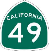 State Route 49
 -
 State Route 65
 -
 State Route 89
 -
 State Route 174
 -
 State Route 267
Public transportation
- Placer County Transit provides basic bus service primarily along the I-80 corridor between Alta and the Watt Ave. Sacramento Regional Transit light rail station. PCT also runs commuter service to Downtown Sacramento.
- The cities of Auburn, Lincoln, and Roseville have their own local transit service. The city of Roseville also offers a commuter service to Sacramento.
- Gold Country Stage (Nevada County) provides a connection between Auburn and Grass Valley.
- Tahoe Area Regional Transit operates in Truckee (Nevada County), Tahoe City and along the North Shore of Lake Tahoe to Incline Village, Nevada.
- Greyhound and Amtrak provide long distance intercity service.
Airports
There are three general aviation airports in Placer County:
The closest commercial airport is Sacramento International Airport in Sacramento.
Communities
Cities
Towns
census-designated places
other communities
Ghost town
Population ranking
The population ranking of the following table is based on the 2010 census of Placer County.[37]
† county seat
| Rank | City/Town/etc. | Municipal type | Population (2010 Census)
|
|---|---|---|---|
| 1 | Roseville | City | 118,788 |
| 2 | Rocklin | City | 56,974 |
| 3 | Lincoln | City | 42,819 |
| 4 | Granite Bay | CDP | 20,402 |
| 5 | † Auburn | City | 13,330 |
| 6 | North Auburn | CDP | 13,022 |
| 7 | Loomis | Town | 6,430 |
| 8 | Kings Beach | CDP | 3,796 |
| 9 | Meadow Vista | CDP | 3,217 |
| 10 | Colfax | City | 1,963 |
| 11 | Sunnyside-Tahoe City | CDP | 1,557 |
| 12 | Foresthill | CDP | 1,483 |
| 13 | Tahoe Vista | CDP | 1,433 |
| 14 | Sheridan | CDP | 1,238 |
| 15 | Newcastle | CDP | 1,224 |
| 16 | Dollar Point | CDP | 1,215 |
| 17 | Tahoma (partially in El Dorado County) | CDP | 1,191 |
| 18 | Penryn | CDP | 831 |
| 19 | Alta | CDP | 610 |
| 20 | Carnelian Bay | CDP | 524 |
| 21 | Dutch Flat | CDP | 160 |
| 22 | Kingvale (mostly in Nevada County) | CDP | 143 |
| 23 | Auburn Rancheria[38] | AIAN | 0 |
See also
- Hiking trails in Placer County
- List of school districts in Placer County, California
- National Register of Historic Places listings in Placer County, California
Notes
- ↑ Other = Some other race + Two or more races
- ↑ Native American = Native Hawaiian or other Pacific Islander + American Indian or Alaska Native
- 1 2 Percentage of registered voters with respect to total population. Percentages of party members with respect to registered voters follow.
- ↑ Only larceny-theft cases involving property over $400 in value are reported as property crimes.
References
- ↑ "Placer County". Geographic Names Information System. United States Geological Survey. Retrieved February 6, 2015.
- ↑ "Mount Baldy-West Ridge". Peakbagger.com. Retrieved February 6, 2015.
- 1 2 3 4 "State & County QuickFacts". United States Census Bureau. Retrieved April 4, 2016.
- ↑ "Find a County". National Association of Counties. Retrieved 2011-06-07.
- ↑ "2010 Census Gazetteer Files". United States Census Bureau. August 22, 2012. Retrieved October 3, 2015.
- ↑ Lake Tahoe census tract blocks, 2000 Census, United States Census Bureau
- 1 2 3 4 5 6 7 8 9 10 11 12 13 14 15 16 17 U.S. Census Bureau. American Community Survey, 2011 American Community Survey 5-Year Estimates, Table B02001. American FactFinder. Retrieved 2013-10-26.
- 1 2 U.S. Census Bureau. American Community Survey, 2011 American Community Survey 5-Year Estimates, Table B03003. American FactFinder. Retrieved 2013-10-26.
- 1 2 U.S. Census Bureau. American Community Survey, 2011 American Community Survey 5-Year Estimates, Table B19301. American FactFinder. Retrieved 2013-10-21.
- 1 2 U.S. Census Bureau. American Community Survey, 2011 American Community Survey 5-Year Estimates, Table B19013. American FactFinder. Retrieved 2013-10-21.
- 1 2 U.S. Census Bureau. American Community Survey, 2011 American Community Survey 5-Year Estimates, Table B19113. American FactFinder. Retrieved 2013-10-21.
- 1 2 U.S. Census Bureau. American Community Survey, 2011 American Community Survey 5-Year Estimates. American FactFinder. Retrieved 2013-10-21.
- ↑ U.S. Census Bureau. American Community Survey, 2011 American Community Survey 5-Year Estimates, Table B01003. American FactFinder. Retrieved 2013-10-21.
- 1 2 3 Data unavailable
- ↑ "County Totals Dataset: Population, Population Change and Estimated Components of Population Change: April 1, 2010 to July 1, 2015". Retrieved July 2, 2016.
- ↑ "U.S. Decennial Census". United States Census Bureau. Retrieved October 3, 2015.
- ↑ "Historical Census Browser". University of Virginia Library. Retrieved October 3, 2015.
- ↑ Forstall, Richard L., ed. (March 27, 1995). "Population of Counties by Decennial Census: 1900 to 1990". United States Census Bureau. Retrieved October 3, 2015.
- ↑ "Census 2000 PHC-T-4. Ranking Tables for Counties: 1990 and 2000" (PDF). United States Census Bureau. April 2, 2001. Retrieved October 3, 2015.
- ↑ "2010 Census P.L. 94-171 Summary File Data". United States Census Bureau.
- ↑ "American FactFinder". United States Census Bureau. Retrieved 2011-05-14.
- ↑ "Placer County, California - Fact Sheet - American FactFinder". Factfinder.census.gov. Retrieved 2010-07-22.
- 1 2 3 4 5 6 7 8 9 10 11 12 13 14 15 16 17 California Secretary of State. February 10, 2013 - Report of Registration. Retrieved 2013-10-31.
- ↑ http://uselectionatlas.org/RESULTS/
- ↑ "Counties by County and by District". California Citizens Redistricting Commission. Retrieved September 24, 2014.
- ↑ "California's 4th Congressional District - Representatives & District Map". Civic Impulse, LLC. Retrieved March 1, 2013.
- ↑ "Communities of Interest — County". California Citizens Redistricting Commission. Retrieved September 28, 2014.
- ↑ "Communities of Interest — County". California Citizens Redistricting Commission. Retrieved September 28, 2014.
- ↑ Duman, Jill (2004-02-14). "Exporting indigence: Social worker calls recent homeless-dumping the 'tip of the iceberg'". Sacramento News & Review. Chico Community Publishing, Inc. Retrieved 2008-07-14.
- ↑ Wiener, Jocelyn (2004-02-22). "Is Placer dumping homeless? With no emergency shelter of its own, county sends its clients to Sacramento, social workers say". Sacramento Bee. The McClatchy Company. Archived from the original on 2008-05-15. Retrieved 2008-07-14.
- ↑ "Castoff practice banned by bills: Shipping homeless across county lines draws legislators' ire" (fee required). Sacramento Bee. The McClatchy Company. May 5, 2006. p. B1. Article 1. Retrieved 2008-07-14.
- ↑ "AB 2745 Assembly Bill - Chaptered". Legislative Counsel, State of California. Retrieved 2008-07-14.
- ↑ "California Health and Safety Code Division 2, Chapter 2, Article 1.". Legislative Counsel, State of California. Retrieved 2008-07-14.
- 1 2 3 4 5 6 7 8 9 10 Office of the Attorney General, Department of Justice, State of California. Table 11: Crimes – 2009. Retrieved 2013-11-14.
- 1 2 3 United States Department of Justice, Federal Bureau of Investigation. Crime in the United States, 2012, Table 8 (California). Retrieved 2013-11-14.
- ↑ County of Placer CAFR
- ↑ http://www.census.gov/2010census/
- ↑ http://www.census.gov/2010census/popmap/ipmtext.php?fl=0120
External links
| Wikimedia Commons has media related to Placer County, California. |
- Official Placer County website
- Placer County Seat Information
- Placer County Library
- Placer Nature Center
- Placer County Museums
- Placer Sentinel Newspaper
- Special Election called for 4th Assembly District, 1/11/2011
- Placer County Network of Care
 |
Yuba County | Nevada County | | |
| Sutter County | |
Washoe County, Nevada and Carson City, Nevada | ||
| ||||
| | ||||
| Sacramento County | El Dorado County | Douglas County, Nevada |
