Pomona Valley

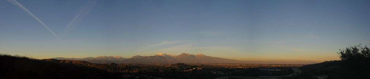
The Pomona Valley is located in the Greater Los Angeles Area between the San Gabriel Valley and San Bernardino Valley in Southern California. The valley is approximately 30 miles east of downtown Los Angeles, which can often be seen from nearby foothills. It ranges from the city of San Dimas from the far west to Rancho Cucamonga to the Far East portion of the valley. The alluvial valley is formed by the Santa Ana River and its tributaries.
The San Antonio Creek runs right through the center of the valley dividing the valley into west and east, and also acts as a section of the border between Los Angeles County and San Bernardino County. It originates from the San Gabriel Mountains watershed around Mount San Antonio (known locally as Mt. Baldy) and joins the Santa Ana River south of Chino. The Pomona Valley is separated from San Gabriel Valley to the west by the northeastern end of the San Jose Hills, running approximately along State Route 57. The eastern boundaries are the Jurupa Hills and the Cajon Pass, (the eastern end of the San Gabriel Mountains) running near Interstate 15, which separates the Pomona Valley from the San Bernardino Valley. The northern boundary is the San Gabriel Mountains. The Chino Hills is the southern boundary that separates the Pomona Valley from northern Orange County. Historic U.S. Route 66 runs east-west across the north side of Pomona Valley.
On March 1, 1893 the California Assembly voted 54-14 for a new county to form in the region, to be named San Antonio County, with Pomona as its seat. Los Angeles interests in the Senate rejected the concept, however, and today the eastern and western portions of the valley remain divided between San Bernardino and Los Angeles counties (San Antonio Creek).[1]
Communities
The cities of Pomona Valley include:
Demographics
The residents of the Pomona Valley are predominantly White and Latino. In contrast to the San Gabriel Valley, the population of Asian Americans is much smaller. Northern areas of the valley that contain the cities of Claremont, La Verne, and San Dimas have large Caucasian populations. Southern portions of the valley that contain the cities of Pomona, Montclair, and Ontario have large Hispanic populations. Portions of the Pomona Valley such as Chino Hills, Diamond Bar, and Walnut contain rather large Asian populations.
Local interest
- American Museum of Ceramic Art, Pomona
- Fairplex, annual Los Angeles County Fair - Pomona
- California State Polytechnic University, Pomona - Pomona
- University of La Verne - La Verne
- Montclair Plaza - Montclair
- Pomona Valley Air Fair - Upland
- Pomona Valley Art Association - Gallery SOHO (located in the Pomona Arts Colony, Pomona)
- The Shoppes at Chino Hills - Chino Hills
- Raging Waters, water park - San Dimas
- Rancho Santa Ana Botanic Garden - Claremont
- Claremont Village - Claremont
- Claremont Colleges - Claremont
- Mt. San Antonio College - Walnut
- Ygnacio Palomares Adobe, List of Registered Historic Places in Los Angeles County, California - Pomona
- La Casa Primera de Rancho San Jose, List of Registered Historic Places in Los Angeles County, California - Pomona
- Victoria Gardens - Rancho Cucamonga
- Ontario Mills - Ontario
Cityscape
Climate
The Pomona Valley experiences a Mediterranean Climate. In contrast to much of the Greater Los Angeles Area, The Pomona Valley can get much hotter summers with high temperatures ranging from the triple digits. Due to its elevation ranging from 800 to 2200 feet, winters in the Pomona Valley can also get cold. Trace amounts of snowfall can occur anywhere above 1500 feet. On the valley floor, average rainfall amounts range anywhere from 12 to 16 inches. Foothill communities can get anywhere from 14 to 18 inches of rain a year. In the fall (fire season), Santa Ana Winds can occur giving strong offshore winds from the Cajon Pass.
| Climate data for Pomona Fairplex, California | |||||||||||||
|---|---|---|---|---|---|---|---|---|---|---|---|---|---|
| Month | Jan | Feb | Mar | Apr | May | Jun | Jul | Aug | Sep | Oct | Nov | Dec | Year |
| Record high °F (°C) | 91 (33) |
94 (34) |
100 (38) |
104 (40) |
106 (41) |
117 (47) |
113 (45) |
110 (43) |
113 (45) |
107 (42) |
97 (36) |
93 (34) |
117 (47) |
| Average high °F (°C) | 65.5 (18.6) |
67.6 (19.8) |
70.1 (21.2) |
74.2 (23.4) |
77.8 (25.4) |
84.1 (28.9) |
91.0 (32.8) |
91.1 (32.8) |
88.4 (31.3) |
80.6 (27) |
73.2 (22.9) |
66.4 (19.1) |
77.5 (25.3) |
| Daily mean °F (°C) | 51.8 (11) |
54.0 (12.2) |
56.2 (13.4) |
59.9 (15.5) |
63.9 (17.7) |
68.8 (20.4) |
74.4 (23.6) |
74.6 (23.7) |
71.9 (22.2) |
65.2 (18.4) |
57.9 (14.4) |
52.4 (11.3) |
62.6 (17) |
| Average low °F (°C) | 38.1 (3.4) |
40.3 (4.6) |
42.3 (5.7) |
45.6 (7.6) |
50.0 (10) |
53.4 (11.9) |
57.7 (14.3) |
58.1 (14.5) |
55.3 (12.9) |
49.8 (9.9) |
42.6 (5.9) |
38.4 (3.6) |
47.6 (8.7) |
| Record low °F (°C) | 21 (−6) |
22 (−6) |
26 (−3) |
29 (−2) |
31 (−1) |
38 (3) |
41 (5) |
42 (6) |
38 (3) |
29 (−2) |
24 (−4) |
22 (−6) |
21 (−6) |
| Average precipitation inches (mm) | 3.56 (90.4) |
3.49 (88.6) |
2.82 (71.6) |
1.22 (31) |
0.35 (8.9) |
0.10 (2.5) |
0.01 (0.3) |
0.07 (1.8) |
0.26 (6.6) |
0.78 (19.8) |
1.56 (39.6) |
2.77 (70.4) |
16.99 (431.5) |
| Source: Western Regional Climate Center[2] | |||||||||||||
Institutions of higher learning
- California State Polytechnic University, Pomona (Cal Poly Pomona), public - Pomona
- Claremont Colleges, liberal arts and engineering - Claremont
- Claremont School of Theology
- DeVry University, technical institute - Pomona
- Mt. San Antonio College, community college - Walnut
- University of La Verne, private - La Verne
- Western University of Health Sciences, private - Pomona
Transportation
International Airports
Public transit
- Foothill Transit
- Omnitrans
- Public transportation in Los Angeles County, California
- Public transportation in San Bernardino County, California
Highways
The Pomona Valley is served by freeways:
- San Bernardino Freeway (Interstate 10) - connects to San Bernardino
- Foothill Freeway (Interstate 210)
- Ontario Freeway (Interstate 15) - connects to Las Vegas, Nevada
- Pomona Freeway (State Route 60) - connects to Riverside
- Chino Valley Freeway (State Route 71)
- Orange Freeway (state route 57)
Major surface thoroughfares serving the Pomona Valley
- Central Ave. (Chino, Montclair, Upland)
- Mountain Ave. (Upland, Ontario, Chino)
- Euclid Ave. (Ontario, Upland, Chino)
- Archibald Ave. (Rancho Cucamonga, Ontario)
- Chino Hills Pkwy. (Diamond Bar, Chino Hills, Chino)
- Haven Ave. (Rancho Cucamonga, Ontario)
- Milliken Ave. (Rancho Cucamonga, Ontario)
- Monte Vista Ave. (Claremont, Upland, Montclair, Chino)
- Foothill Blvd. "(San Dimas, La Verne, Claremont, Upland, Rancho Cucamonga)"
- Bonita Ave. (San Dimas, La Verne, Pomona, Claremont)"
- Base Line Rd. (San Dimas, La Verne, Claremont)"
- Indian Hill Blvd. (Claremont, Pomona)
- Grand Ave. (Chino Hills, Diamond Bar, Walnut)
- Towne Ave. (Claremont, Pomona)
- Garey Ave. (Chino Hills, Pomona, Claremont)
- Arrow Hwy. (San Dimas, La Verne, Pomona, Claremont)
- Arrow Rte. (Upland, Rancho Cucamonga)
- Holt Ave. (Pomona; becomes Valley Blvd from Pomona to Los Angeles)
- Valley Blvd. (Walnut, Pomona)
- Holt Blvd. (Pomona, Montclair, Ontario)
- Mission Blvd. (Pomona, Montclair, Ontario)
- Mount Baldy Road (Claremont, San Antonio Heights, Mount Baldy, and Mt. San Antonio)
In Claremont, Mt. Baldy Road leads into the Mt. Baldy Ski Lifts of Mount San Antonio (nicknamed "Mt. Baldy") in the San Gabriel Mountains.
Media
Newspapers serving the area
- Claremont Courier
- Inland Valley Daily Bulletin, with its offices located in Rancho Cucamonga
- San Gabriel Valley Tribune, serves western Pomona Valley
See also
References
- ↑ "History timeline of the Inland Empire, California". San Bernardino County Sun. October 30, 2007. Retrieved 2007-11-15.
- ↑ "POMONA FAIRPLEX, CALIFORNIA (047050)". Western Regional Climate Center. Retrieved May 2016. Check date values in:
|access-date=(help)
