Owens Valley
| Owens Valley | |
|---|---|
 | |
| Floor elevation | 4,000 feet (1,200 m) |
| Long-axis direction | North to South |
| Long-axis length | 75 miles (121 km) |
| Geography | |
| Bounded by |
Inyo Mountains (E) Coso Range (SE) Rose Valley (S) Sierra Nevada (W) Chalfant Valley (N)[1] |
| Coordinates | 36°48′09″N 118°11′59″W / 36.80250°N 118.19972°WCoordinates: 36°48′09″N 118°11′59″W / 36.80250°N 118.19972°W |
| Watercourses | Owens River |
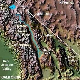
Owens Valley is the arid valley of the Owens River in eastern California in the United States, to the east of the Sierra Nevada and west of the White Mountains and Inyo Mountains on the west edge of the Great Basin section. The mountain peaks on either side (including Mount Whitney) reach above 14,000 feet (4,300 m) in elevation, while the floor of the Owens Valley is at 4,000 feet (1,200 m), making the valley one of the deepest in the United States.[2] The Sierra Nevada casts the valley in a rain shadow, which makes Owens Valley "the Land of Little Rain."[3] The bed of Owens Lake, now a predominantly dry endorheic alkali flat, sits on the southern end of the valley.
The valley provides water to the Los Angeles Aqueduct, the source of half of the water for Los Angeles, and is infamous as the scene of one of the fiercest and longest running episodes of the California Water Wars.[4] These episodes inspired aspects of the film Chinatown.
Towns in the Owens Valley include Bishop, Lone Pine, Independence and Big Pine. The major road in the valley is U.S. Route 395.
Geology
About three million years ago, the Sierra Nevada Fault and the White Mountains Fault systems became active with repeated episodes of slip earthquakes gradually producing the impressive relief of the eastern Sierra Nevada and White Mountain escarpments that bound the northern Owens Valley-Mono Basin region.
Owens Valley is a graben—a downdropped block of land between two vertical faults. Owens Valley is the westernmost graben in the Basin and Range Province. It is also part of a trough which extends from Oregon to Death Valley called the Walker Lane.[5]
The western flank of much of the valley has large moraines coming off the Sierra Nevada. These unsorted piles of rock, boulders, and dust were pushed to where they are by glaciers during the last ice age. An excellent example of a moraine is on State Route 168 as it climbs into Buttermilk Country.[5]
This graben was formed by a long series of earthquakes, such as the 1872 Lone Pine earthquake, that have moved the graben down and helped move the Sierra Nevada up. The graben is in fact much larger than the depth of the valley suggests; gravity studies suggest that 10,000 feet (3,000 m) of sedimentary rock mostly fills the graben and that a very steep escarpment is buried under the western length of the valley. The topmost part of this escarpment is exposed at Alabama Hills.
See also: Inyo and Mono Craters. Smaller versions of the Devils Postpile, can be found, for example, by Little Lake.

%2C%22_California%2C_1936.%2C_ca._1936_-_NARA_-_519935.jpg)
Ecology
The valley contains plants adapted to alkali flat habitat. One of these, the Owens Valley checkerbloom (Sidalcea covillei), is endemic to Owens Valley.
History
The valley was inhabited in late prehistoric times by the Timbisha (also called Panamint or Koso) in the extreme south end around Owens Lake and by the Mono tribe (also called Owens Valley Paiute) in the central and northern portions of the valley. The Timbisha speak the Timbisha language, classified in the Numic branch of Uto-Aztecan language family. The closest related languages are Shoshoni and Comanche. The Eastern Mono speak a dialect of the Mono language which is also Numic, but is more closely related to Northern Paiute. The Timbisha presently live in Death Valley at Furnace Creek although most families also have summer homes in the Lone Pine colony. The Eastern Mono live in several colonies from Lone Pine to Bishop. Trade between Native Americans of the Owens Valley between coastal tribes such as the Chumash has been indicated by the archaeological record.[6]
On May 1, 1834, Joseph R. Walker entered Owens Valley at the mouth of Walker Pass. He and his group of 52 men traveled up the valley on their way back to the Humboldt Sink, and back up the Humboldt River to the Rocky Mountains.[7]
In 1845, John C. Fremont named the Owens valley, river and lake for Richard Owens, one of his guides. Camp Independence was established on Oak Creek nearby modern Independence, California, on July 4, 1862,[8] during the Owens Valley Indian War.[9]
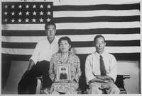
From 1942 to 1945 during World War II, the first Japanese American Internment camp operated in the valley at Manzanar near Independence, California.

California Water Wars
In the early 20th century, the valley became the scene of a struggle between local residents and the city of Los Angeles over water rights. William Mulholland, superintendent of the Los Angeles Department of Water and Power (LADWP) planned the 223-mile (359 km) Los Angeles Aqueduct, completed in 1913, which diverted water from the Owens River. The water rights were acquired in a deceitful manner, often splitting water cooperatives and pitting neighbors against one another. In 1924, local farmers were fed up with the purchases and erupted in violence, sabotaging parts of the water system.[2]
Eventually Los Angeles acquired a large portion of the water rights to over 300,000 acres (121,000 ha) of land in the valley, almost completely diverting the inflows of water away from Owens Lake. This acquisition was made following negotiations in which Los Angeles and the Owens Valley farmers were engaged in a bilateral monopoly. By modern estimates, Los Angeles would have been willing to pay up to $8.70 per acre-foot ($7.05/thousand cubic meters) of water. Eventually the average actual transaction price was near $4.00 per acre-foot ($3.25/thousand cubic meters). The next best option was continuing to use the land for agricultural uses, which fetched a much lower price. Although this price was lower than Los Angeles' willingness to pay, the farmers of Owens Valley received a premium for their land compared to land values in neighboring counties. More over, the farmers who resisted the longest during the Owens Valley Transfers were able to sell their land for even higher prices than the average farmer received due to Los Angeles' willingness to settle.[10] As a result of these acquisitions, the lake subsequently dried up completely, leaving the present alkali flat which plagues the southern valley with alkali dust storms.
In 1970, LADWP completed a second aqueduct from Owens Valley. More surface water was diverted and groundwater was pumped to feed the aqueduct. Owens Valley springs and seeps dried and disappeared, and groundwater-dependent vegetation began to die.[2]
Years of litigation followed. In 1997, Inyo County, Los Angeles, the Owens Valley Committee, the Sierra Club, and other concerned parties signed a Memorandum of Understanding that specified terms by which the lower Owens River would be rewatered by June 2003.[11] LADWP missed this deadline and was sued again. Under another settlement, this time including the state of California, Los Angeles promised to rewater the lower Owens River by September 2005. As of February 2005, LADWP announced it was unlikely to meet this extended deadline. Finally, in 2008, Los Angeles fulfilled its promise and rewatered the lower Owens River.[12]
In July 2004, Los Angeles mayor James Hahn proposed barring all future development on its Owens Valley holdings, by proposing a conservation easement for all LADWP land.[13] As of October 2004, Inyo County officials seemed to be resisting the offer of the easement, perhaps due to the prior history of mistrust over LADWP actions. Los Angeles began using a new, organic method of suppressing airborne dust from the dry bed of Owens Lake in 2014 per an agreement between the city and Great Basin Unified Air Pollution Control District, the Owens Valley air quality regulators, ending a bitter decades-long dispute over the water and dust.[14]

Radio observatory
The Owens Valley Radio Observatory located near Westgard Pass is one of ten dishes making up the Very Long Baseline Array (VLBA).
See also
- Owens River
- Bibliography of the Sierra Nevada — for further reading.
Notes
- ↑ "Owens Valley". Geographic Names Information System. United States Geological Survey. Retrieved 2009-05-03.
- 1 2 3 Smith, Genny; Jeff Putnam (1976). Deepest Valley: a Guide to Owens Valley, its roadsides and mountain trails (2nd ed.). Genny Smith books. Sierra Club. ISBN 0-931378-14-1.
- ↑ Austin, Mary Hunter (1903). Land of Little Rain. Houghton, Mifflin and Company. ISBN 0-8263-0358-7.
- ↑ "Los Angeles Aqueduct". LADWP
- 1 2 Alt; Hyndman (2000). Roadside Geology of Northern and Central California. Missoula: Mountain Press Publishing Company. ISBN 0-87842-409-1.
- ↑ Hogan, C. Michael (2008). Andy Burnham, ed. "Los Osos Back Bay". Megalithic Portal.
- ↑ Gilbert, Bil (1985) [1983]. Westering Man: The Life of Joseph Walker. Tulsa: University of Oklahoma Press. pp. 144–46. ISBN 0806119349.
- ↑ Hart, Herbert M. "Camp Independence (Inyo County)". Digital Desert.
- ↑ Key, V., John W. (1979). The Owens Valley Indian War, 1861-1865 (Thesis). Fort Leavenworth, Kansas: U.S. Army Command and General Staff College.
- ↑ Libecap, Gary D. (2008-04-05). "Chinatown Revisited: Owens Valley and Los Angeles—Bargaining Costs and Fairness Perceptions of the First Major Water Rights Exchange" (PDF). Journal of Law, Economics, and Organization. 24 (2).
- ↑ "The 1997 MOU". Inyo County Water Department
- ↑ "L.A. Returns Water to the Owens Valley". NPR
- ↑ Broder, John M. (2004-08-08). "Los Angeles Mayor Seeks To Freeze Valley Growth". The New York Times. Retrieved 2010-05-20. New York Times
- ↑ Sahagun, Louis (November 14, 2014). "New dust-busting method ends L.A.'s longtime feud with Owens Valley". Los Angeles Times.
References
- Cadillac Desert, Marc Reisner, revised edition, Penguin USA, (1993), ISBN 0-14-017824-4
- Geology Underfoot in Death Valley and Owens Valley, Sharp, Glazner (Mountain Press Publishing Company, Missoula; 1997) ISBN 0-87842-362-1
- Spirit in the Desert: Pilgrimages to Sacred Sites in the Owens Valley, Brad Karelius, BookSurge Publishing, (2009). ISBN 1-4392-1721-1, 0-520-07245-6
- Western Times and Water Wars, John Walton, University of California Press, (1992). ISBN 978-1-4392-1721-4
- The Water Seekers, Remi Nadeau, Crest Publishers, (4th edition: 1997), ISBN 0-9627104-5-8
External links
| Wikimedia Commons has media related to Owens Valley. |
- The Owens Valley Committee: The Owens Valley
- Cenozoic/Mesozoic Volcanism of the Eastern Sierra Nevada
- Groundwater Quality in the Owens Valley, California United States Geological Survey
- Lower Owens River Project - 60-mile (97 km) restoration of the lower owens river
- Inyo County Water Department
- Eval. of the Hydrologic System and Selected Water-Management Alternatives in the Owens Valley, California
- Roadside Geology and Mining History of the Owens Valley and Mono Basin