San Francisco Bay
| San Francisco Bay | |
|---|---|
 | |
| Coordinates | 37°42′30″N 122°16′49″W / 37.70833°N 122.28028°WCoordinates: 37°42′30″N 122°16′49″W / 37.70833°N 122.28028°W |
| Type | Bay |
| River sources |
Sacramento River San Joaquin River Petaluma River Napa River Guadalupe River |
| Ocean/sea sources | Pacific Ocean |
| Basin countries | United States |
| Max. length | 97 km (60 mi) |
| Max. width | 19 km (12 mi) |
| Surface area | 400 to 1,600 sq mi (1,000 to 4,100 km2) |
| Settlements |
San Francisco Oakland San Jose |
The San Francisco Bay is a shallow estuary that drains water from approximately 40% of California. Water from the Sacramento and San Joaquin rivers, and from the Sierra Nevada mountains, passes through the bay to the Pacific Ocean. Specifically, both rivers flow into Suisun Bay, which flows through the Carquinez Strait to meet with the Napa River at the entrance to San Pablo Bay, which connects at its south end to San Francisco Bay. However, the entire group of interconnected bays is often called the San Francisco Bay.
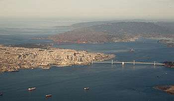
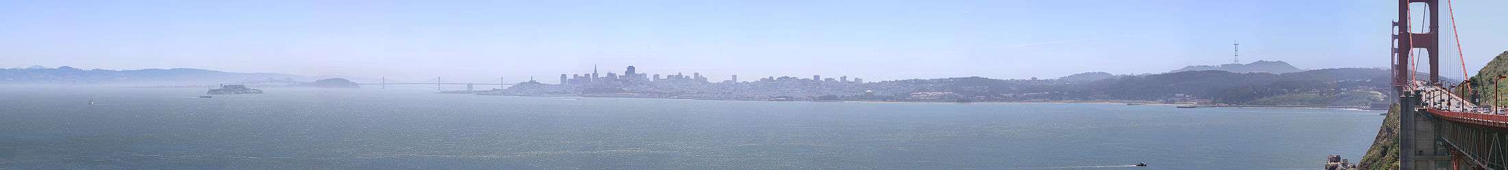
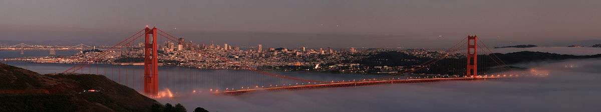
San Francisco Bay is in the U.S. state of California, surrounded by a contiguous region known as the San Francisco Bay Area (often simply "the Bay Area"), dominated by the large cities San Francisco, Oakland, and San Jose. The waterway entrance to San Francisco Bay from the Pacific Ocean is called the Golden Gate. Across the strait spans the Golden Gate Bridge. The bay was designated a Ramsar Wetland of International Importance on February 2, 2013.
Size
The bay covers somewhere between 400 and 1,600 square miles (1,040 to 4,160 square kilometers), depending on which sub-bays (such as San Pablo Bay), estuaries, wetlands, and so on are included in the measurement.[1][2] The main part of the Bay measures 3 to 12 miles (5 to 20 km) wide east-to-west and somewhere between 48 miles (77 km)1 and 60 miles (97 km)2 north-to-south. It is the largest Pacific estuary in the Americas.
The bay was navigable as far south as San Jose until the 1850s, when hydraulic mining released massive amounts of sediment from the rivers that settled in those parts of the bay that had little or no current. Later, wetlands and inlets were deliberately filled in, reducing the Bay's size since the mid-19th century by as much as one third. Recently, large areas of wetlands have been restored, further confusing the issue of the Bay's size. Despite its value as a waterway and harbor, many thousands of acres of marshy wetlands at the edges of the bay were, for many years, considered wasted space. As a result, soil excavated for building projects or dredged from channels was often dumped onto the wetlands and other parts of the bay as landfill.
From the mid-19th century through the late 20th century, more than a third of the original bay was filled and often built on. The deep, damp soil in these areas is subject to liquefaction during earthquakes, and most of the major damage close to the Bay in the Loma Prieta earthquake of 1989 occurred to structures on these areas.
The Marina District of San Francisco, hard hit by the 1989 earthquake, was built on fill that had been placed there for the Panama-Pacific International Exposition (1915), although liquefaction did not occur on a large scale. In the 1990s, San Francisco International Airport proposed filling in hundreds more acres to extend its overcrowded international runways in exchange for purchasing other parts of the bay and converting them back to wetlands. The idea was, and remains, controversial. (For further details, see the "Bay Fill and Depth Profile" section.)

There are five large islands in San Francisco Bay. Alameda, the largest island, was created when a shipping lane was cut in 1901. It is now predominantly a bedroom community. Angel Island was known as "Ellis Island West" because it served as the entry point for immigrants from East Asia. It is now a state park accessible by ferry. Mountainous Yerba Buena Island is pierced by a tunnel linking the east and west spans of the San Francisco–Oakland Bay Bridge. Attached to the north is the artificial and flat Treasure Island, site of the 1939 Golden Gate International Exposition. From the Second World War until the 1990s, both islands served as military bases and are now being redeveloped. Isolated in the center of the Bay is Alcatraz, the site of the famous federal penitentiary. The federal prison on Alcatraz Island no longer functions, but the complex is a popular tourist site. Despite its name, Mare Island in the northern part of the bay is a peninsula rather than an island.
Geology
San Francisco Bay is thought to represent a down-warping of the Earth's crust between the San Andreas Fault to the west and the Hayward Fault to the east, though the precise nature of this remains under study. During the last ice age, the basin now filled by the bay was a large linear valley with small hills, similar to most of the valleys of the Coast Ranges. The rivers of the Central Valley ran out to sea through a canyon that is now the Golden Gate. As the great ice sheets melted, sea level rose 300 feet (91 m) over 4,000 years, and the valley filled with water from the Pacific, becoming a bay. The small hills became islands.
History
The first European to see San Francisco Bay is likely N. de Morena who was left at New Albion at Drakes Bay in Marin County, California by Sir Francis Drake in 1579 and then walked to Mexico.[3][4]
The first recorded European discovery of San Francisco Bay was on November 4, 1769 when Spanish explorer Gaspar de Portolà, unable to find the port of Monterey, California, continued north close to what is now Pacifica and reached the summit of the 1,200-foot (370 m) high Sweeney Ridge, now marked as the place where he first sighted San Francisco Bay. Portolá and his party did not realize what they had discovered, thinking they had arrived at a large arm of what is now called Drakes Bay.[5] At the time, Drakes Bay went by the name Bahia de San Francisco and thus both bodies of water became associated with the name. Eventually, the larger, more important body of water fully appropriated the name San Francisco Bay.
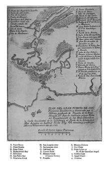
The first European to enter the bay is believed to have been the Spanish explorer Juan de Ayala, who passed through the Golden Gate on August 5, 1775 in his ship the San Carlos, and moored in a bay of Angel Island now known as Ayala Cove. Ayala continued to explore the Bay area and the expedition's cartographer, José de Cañizares, gathered the information necessary to produce the first map of the San Francisco Bay area. A number of place names survive (anglicized) from that first map, including Point Reyes, Angel Island, Farallon Islands and Alcatraz Island.
The United States seized the region from Mexico during the Mexican–American War (1846–48). On February 2, 1848 California was annexed to the U.S. with the signing of the Treaty of Guadalupe Hidalgo. A year and a half later, California requested to join the United States on December 3, 1849 and was accepted as the 31st State of the union on September 9, 1850.
The bay became the center of American settlement and commerce in the Far West through most of the remainder of the 19th century. During the California Gold Rush (1848–55), San Francisco Bay suddenly became one of the world's great seaports, dominating shipping in the American West until the last years of the 19th century. The bay's regional importance increased further when the First Transcontinental Railroad was connected to its western terminus at Alameda on September 6, 1869.[6] The terminus was switched to the Oakland Long Wharf two months later on November 8, 1869.[7]

During the 20th Century, the bay was subject to the Reber Plan, which would have filled in parts of the bay in order to increase industrial activity along the waterfront. In 1959, the United States Army Corps of Engineers released a report stating that if current infill trends continued, the bay would be as big as a shipping channel by 2020. This news created the Save the Bay movement in 1960, which mobilized to stop the infill of wetlands and the bay in general, which had shrunk to two-thirds of its size in the century before 1961.[8]
San Francisco Bay continues to support some of the densest industrial production and urban settlement in the United States. The San Francisco Bay Area is the American West's second-largest urban area with approximately 8 million residents.
Ecology
Despite its urban and industrial character, San Francisco Bay and the Sacramento-San Joaquin Delta remain perhaps California's most important ecological habitats. California's Dungeness crab, California halibut, and Pacific salmon fisheries rely on the bay as a nursery. The few remaining salt marshes now represent most of California's remaining salt marsh, supporting a number of endangered species and providing key ecosystem services such as filtering pollutants and sediments from the rivers. San Francisco Bay is recognized for protection by the California Bays and Estuaries Policy, with oversight provided by the San Francisco Estuary Partnership.[9]
Most famously, the bay is a key link in the Pacific Flyway. Millions of waterfowl annually use the bay shallows as a refuge. Two endangered species of birds are found here: the California least tern and the California clapper rail. Exposed bay muds provide important feeding areas for shorebirds, but underlying layers of bay mud pose geological hazards for structures near many parts of the bay perimeter. San Francisco Bay provided the nation's first wildlife refuge, Oakland's artificial Lake Merritt, constructed in the 1860s, and America's first urban National Wildlife Refuge, the Don Edwards San Francisco Bay National Wildlife Refuge (SFBNWR) in 1972. The Bay is also plagued by non-native species.
Salt produced from San Francisco Bay is produced in salt evaporation ponds and is shipped throughout the Western United States to bakeries, canneries, fisheries, cheese makers and other food industries and used to de-ice winter highways, clean kidney dialysis machines, for animal nutrition, and in many industries. Many companies have produced salt in the Bay, with the Leslie Salt Company the largest private land owner in the Bay Area in the 1940s.[10][11]
Low-salinity salt ponds mirror the ecosystem of the bay, with fish and fish-eating birds in abundance. Mid-salinity ponds support dense populations of brine shrimp, which provide a rich food source for millions of shorebirds. Only salt-tolerant micro-algae survive in the high salinity ponds, and impart a deep red color to these ponds from the pigment within the algae protoplasm.
The seasonal range of water temperature in the Bay is from January's 53 °F (12 °C) to September's 60 °F (16 °C) when measured at Fort Point, which is near the southern end of the Golden Gate Bridge and at the entrance to San Francisco Bay.[12]
Industrial, mining, and other uses of mercury have resulted in a widespread distribution in the bay, with uptake in the bay's phytoplankton and contamination of its sportfish.[13] In January 1971, two Standard Oil tankers collided in the bay, creating an 800,000 gallon oil spill disaster, which spurred environmental protection of the bay. In November 2007, a ship named COSCO Busan collided with the San Francisco–Oakland Bay Bridge and spilled over 58,000 gallons of bunker fuel, creating the largest oil spill in the region since 1996.[14]
For the first time in 65 years, Pacific Harbor Porpoise (Phocoena phocoena) returned to the Bay in 2009.[15] Golden Gate Cetacean Research, a non-profit organization focused on research on cetaceans, has developed a photo-identification database enabling the scientists to identify specific porpoise individuals and is trying to ascertain whether a healthier bay has brought their return.[16] Pacific harbor porpoise range from Point Conception, California to Alaska and across to the Kamchatka Peninsula and Japan. Recent genetic studies show that there is a local stock from San Francisco to the Russian River and that eastern Pacific coastal populations rarely migrate far, unlike western Atlantic Harbor porpoise.[17]
Bay fill and depth profile
San Francisco Bay's profile changed dramatically in the late 19th century and again with the initiation of dredging by the US Army Corps of Engineers in the 20th century. Before about 1860, most bay shores (exception: rocky shores such as those in Carquinez Strait, along Marin shoreline, Point Richmond, Golden Gate area) contained extensive wetlands that graded nearly invisibly from freshwater wetlands to salt marsh and then tidal mudflat. A deep channel ran through the center of the bay, following the ancient drowned river valley.
In the 1860s and continuing into the early 20th century, miners dumped staggering quantities of mud and gravel from hydraulic mining operations into the upper Sacramento and San Joaquin Rivers. GK Gilbert's estimates of debris total more than eight times the amount of rock and dirt moved during construction of the Panama Canal. This material flowed down the rivers, progressively eroding into finer and finer sediment, until it reached the bay system. Here some of it settled, eventually filling in Suisun Bay, San Pablo Bay, and San Francisco Bay, in decreasing order of severity.
By the end of the 19th century, these "slickens" had filled in much of the shallow bay flats, raising the entire bay profile. New marshes were created in some areas.

In the decades surrounding 1900, at the behest of local political officials and following Congressional orders, the US Army Corps began dredging the Sacramento and San Joaquin Rivers and the deep channels of San Francisco Bay. This work has continued without interruption ever since an enormous federal subsidy to San Francisco Bay shipping. Some of the dredge spoils were initially dumped in the bay shallows (including helping to create Treasure Island on the former shoals to the north of Yerba Buena Island) and used to raise an island in the Sacramento-San Joaquin Delta. The net effect of dredging has been to maintain a narrow deep channel—deeper perhaps than the original bay channel—through a much shallower bay. At the same time, most of the marsh areas have been filled or blocked off from the bay by dikes.
Large ships transiting the bay must follow deep underwater channels that are maintained by frequent dredging as the average depth of the Bay is only as deep as a swimming pool—approximately 12 to 15 ft (3.7 to 4.6 m). Between Hayward and San Mateo to San Jose it is 12 to 36 in (300 to 910 mm). The deepest part of the bay is under and out of the Golden Gate Bridge, at 372 ft (113 m).[18]
In the late 1990s, a 12-year harbor-deepening project for the Port of Oakland began; it was largely completed by September 2009. Previously, the bay waters and harbor facilities only allowed for ships with a draft of 46 ft (14 m), but dredging activities undertaken by the United States Army Corps of Engineers in partnership with the Port of Oakland succeeded in providing access for vessels with a 50-foot (15 m) draft. Four dredging companies were employed in the $432 million project, with $244 million paid for with federal funds and $188 million supplied by the Port of Oakland. Some 6,000,000 cubic yards (4,600,000 m3) of mud from the dredging was deposited at the western edge of Middle Harbor Shoreline Park to become a 188-acre (76 ha) shallow-water wetlands habitat for marine and shore life.[19][20] Further dredging followed in 2011, to maintain the navigation channel.[21][22] This dredging enabled the arrival of the largest container ship ever to enter the San Francisco Bay, the MSC Fabiola. Bay pilots trained for the visit on a simulator at the California Maritime Academy for over a year. The ship arrived drawing less than its full draft of 50 feet 10 inches (15.5 m) because it held only three-quarters of a load after its stop in Long Beach.[23]
Transportation
San Francisco Bay was traversed by watercraft since long before the coming of Europeans. Indigenous peoples used canoes to fish and clam along the shoreline. The era of sail brought ships that connected the area to the rest of the world—and served as early ferries and freighters within the Bay and between the Bay and inland ports, such as Sacramento and Stockton. These were gradually replaced by steam-powered vessels starting in the late 19th century. Several shipyards were early established around the Bay, augmented during wartime. (e.g., the Kaiser Shipyards)
San Francisco Bay is spanned by eight bridges, all dedicated to vehicle traffic.
- The Golden Gate Bridge on U.S. Route 101/State Route 1 (US 101/SR 1) was the largest single span suspension bridge ever built at the time of its construction. It spans the Golden Gate, the strait between San Francisco and Marin County, and is the only bridge in the area not owned by the State of California.
- The Richmond–San Rafael Bridge on Interstate 580 (I-580) connects Marin and Contra Costa counties.
- The San Francisco–Oakland Bay Bridge on I-80 connects Alameda and San Francisco counties.
- The San Mateo–Hayward Bridge on SR 92 connects Alameda and San Mateo counties.
- The Dumbarton Bridge on SR 84 connects Alameda and San Mateo counties.
- The Carquinez Bridge (including the Alfred Zampa Memorial Bridge) on I-80 connects Contra Costa and Solano counties.
- The Benicia Bridge on I-680 also connects Contra Costa and Solano counties.
- The Antioch Bridge on SR 160 connects Contra Costa and Sacramento counties.
The Transbay Tube, an underwater tube that BART runs through, runs from Oakland to San Francisco. Prior to the bridges and, later, the Transbay Tube, transbay transportation was dominated by fleets of ferryboats operated by the Southern Pacific Railroad and the Key System transit company. However, in recent decades, ferries have returned, primarily serving commuters from Marin County, relieving the traffic bottleneck of the Golden Gate Bridge. (See article Ferries of San Francisco Bay).
- The Dumbarton Rail Bridge is an abandoned bridge that used to carry rail traffic.
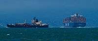
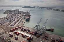
The Bay also continues to serve as a major international shipping port, served by a large container facility operated by the Port of Oakland, and two smaller facilities in Richmond and San Francisco.
Recreation
San Francisco Bay is a mecca for sailors (boats, as well as windsurfing and kitesurfing), due to consistent strong westerly/northwesterly thermally-generated winds (Beaufort force 6 (15-25 knots) is common on summer afternoons) and protection from large open ocean swells. Yachting and yacht racing are popular pastimes and the San Francisco Bay Area is home to many of the world's top sailors. A shoreline bicycle and pedestrian trail known as the San Francisco Bay Trail encircles the edge of the bay. The San Francisco Bay Area Water Trail, a growing network of launching and landing sites around the Bay for non-motorized small boat users (such as kayakers) is being developed. Parks and protected areas around the bay include Eden Landing Ecological Reserve, Hayward Regional Shoreline, Don Edwards San Francisco Bay National Wildlife Refuge, Hayward Shoreline Interpretive Center, Crown Memorial State Beach, Eastshore State Park, Point Isabel Regional Shoreline, Brooks Island Regional Shoreline, and César Chávez Park.
The San Francisco Bay Area Water Trail is a planned system of designated trailheads designed to improve non-motorized small boat access to the bay. The California Coastal Conservancy approved funding in March 2011 to begin implementation of the water trail.

Gallery
 "San Francisco Bay", painting by Albert Bierstadt, 1871–73
 The City of Berkeley, the Bay and Marin County in the background as seen from the Claremont Canyon reserve
 Mount Tamalpais view across San Pablo Bay at Point Pinole Regional Shoreline in Richmond
 Looking north into San Pablo Bay at the Richmond-San Rafael Bridge, 2010
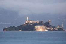 Alcatraz at dawn on San Francisco Bay
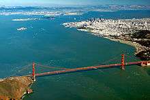
 Aerial view of Golden Gate and the northern Bay, looking east from the Pacific
 People also swim recreationally, at Kellar Beach in Richmond's Miller/Knox Regional Shoreline.
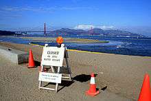 Oil Spill in the Bay
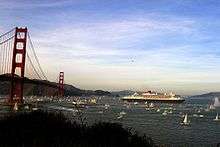 RMS Queen Mary 2 in San Francisco Bay
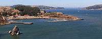 Fort Baker on San Francisco Bay, just east of the Golden Gate
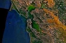 NASA satellite image, showing water flow
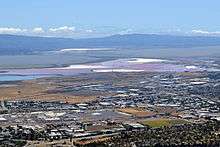 Salt ponds at the southern tip of the bay
See also

- Golden Gate
- Golden Gate Bridge
- Hydrography of the San Francisco Bay Area
- Islands of San Francisco Bay
- McLaughlin Eastshore State Park
- Mount Diablo
- Mount Tamalpais State Park
- Napa Sonoma Marsh
- Point Pinole Regional Shoreline, Richmond
People
- J.C. Barthel, who prepared "plans for the docks and other water-front improvements in the San Francisco Bay district"
References
- ↑ Symphonies in Steel: San Francisco – Oakland Bay Bridge and the Golden Gate
- ↑ San Francisco Bay Watershed Database and Mapping Project Archived October 30, 2004, at the Wayback Machine.
- ↑ Aker, Raymond (1970). REPORT OF FINDINGS RELATING TO THE IDENTIFICATION OF SIR FRANCIS DRAKE'S ENCAMPMENT AT POINT REYES NATIONAL SEASHORE (PDF). pp. 338–340.
- ↑ Charles F. Lumis, ed. (1900). "Narrative of the Pilot Morera, who passed through the North Sea to the South Sea through the Strait". The Land of Sunshine, The Magazine of California and the West (February). pp. 184–186.
- ↑ The representations of San Francisco (California): a portable harbor in the fragile geography of the North Pacific.
- ↑ Alta California, September 7, 1869
- ↑ Cprr.org
- ↑ "History". Save the Bay. Retrieved 14 July 2015.
- ↑ State Water Resources Control Board Water Quality Control Policy for the Enclosed Bays and Estuaries of California (1974) State of California
- ↑ Spatial History Project
- ↑ Hidden Ecologies » Blog Archive » Arden Salt Works
- ↑ Osborn, Liz. "Average Ocean Water Temperatures at San Francisco". Current Results Nexus. Retrieved October 19, 2013.
- ↑ Conaway CH; Black FJ; Grieb TM; Roy S; Flegal AR (2008). "Mercury in the San Francisco Estuary". Rev Environ Contam Toxicol. 194: 29–54. doi:10.1007/978-0-387-74816-0_2. PMID 18069645.
- ↑ Bailey, Eric (November 9, 2007). "Oil oozes in S.F. Bay after ship hits bridge - Los Angeles Times". Los Angeles Times.
- ↑ David Perlman (2010-11-08). "Porpoises return to SF Bay - scientists study why". San Francisco Chronicle. Retrieved 2011-07-25.
- ↑ "Harbor Porpoise Project". Golden Gate Cetacean Research. Retrieved 2011-07-25.
- ↑ Harbor Porpoise (Phocoena phocoena): San Francisco-Russian River Stock (PDF) (Report). National Marine Fisheries Service. 2009-10-15. Retrieved 2011-07-25.
- ↑ Barnard, Patrick; Hanes, Rubin, Kvitek (18 July 2006). "Giant Sand Waves at the Mouth of San Francisco Bay" (PDF). Eos. 87 (29).
- ↑ Port of Oakland (September 21, 2009). "Port of Oakland, California, completes 50-foot-deepening project, allowing it to accommodate larger container ships". Industry Intelligence. Retrieved March 23, 2012.
- ↑ United States. Army. Corps of Engineers. San Francisco District, Port of Oakland (1998). Oakland harbor navigation improvement (-50 foot) project: draft environmental impact statement/environmental impact report: executive summary. U.S. Army Corps of Engineers, San Francisco District.
- ↑ "USA: Port of Oakland Secures USD 18 Million in Federal Funding for Dredging Project". Dredging Today. June 1, 2011. Retrieved March 22, 2012.
- ↑ "USA: Congresswoman Helps Oakland Port Reach Major Funding Milestone for Deepening Project". Dredging Today. March 21, 2012. Retrieved March 22, 2012.
- ↑ Matthews, Mark (March 22, 2012). "Huge container ship cruises into Port of Oakland". ABC7. San Francisco: KGO-TV/DT. Retrieved March 23, 2012.
External links
| Wikimedia Commons has media related to San Francisco Bay. |
| Wikisource has the text of the 1879 American Cyclopædia article San Francisco Bay. |
- San Francisco Bay: Portrait of an Estuary, David Sanger and John Hart, University of California Press
- Barging In - A Short History of Liveaboards on the Bay
- The Islands of San Francisco Bay, James A. Martin | Michael T. Lee, Down Window Press
- Army Corps of Engineers Bay Model: Working scale model of the Bay
- SF Bay Kayak, Canoe, and Boat Launch Ramp guide. A collaboratively edited guide to the SF bay.
- BoatingSF.com: Photos of SF Bay and its boats, plus online cruising guide
- SF Estuary Institute: San Francisco Bay Historical View Maps
- Save San Francisco Bay: Protect and Restore San Francisco Bay
- sfbaywildlife.info Guide to San Francisco Bay wildlife
- Early History of the California Coast, a National Park Service Discover Our Shared Heritage Travel Itinerary
- Cartography & History The representations of San Francisco Bay: a portable harbor in the fragile geography of the North Pacific
- San Francisco Estuary and Watershed Science: a peer-reviewed online science journal
Literature
- The Bay of San Francisco: the metropolis of the Pacific Coast and its suburban cities: a history. Volume I. by Lewis Publishing Company, Chicago, Ill. Published 1892 Contains index to biographical sketches
- Volume II - Biographies
| Bodies of water |
| |
|---|---|---|
| Counties | ||
| Major cities | ||
| Cities and towns 100k–250k | ||
| Cities and towns 50k–99k | ||
| Cities and towns 25k-50k | ||
| Cities and towns 10k–25k |
| |
| Sub-regions | ||