Santa Ana, California
| Santa Ana, California | |||||||
|---|---|---|---|---|---|---|---|
| City | |||||||
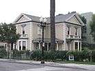
Clockwise from top: Old Orange County Courthouse, Bowers Museum, Discovery Cube Orange County, Minter House, Santa Ana Regional Transportation Center | |||||||
| |||||||
| Motto: Education First | |||||||
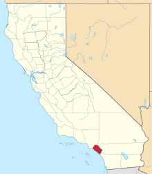
 Location of Santa Ana within Orange County, California | |||||||
 Santa Ana Location in the United States | |||||||
| Coordinates: 33°44′27″N 117°52′53″W / 33.74083°N 117.88139°WCoordinates: 33°44′27″N 117°52′53″W / 33.74083°N 117.88139°W | |||||||
| Country | United States | ||||||
| State | California | ||||||
| County | Orange | ||||||
| Founded | 1869[1] | ||||||
| Incorporated | June 1, 1886[2] | ||||||
| Government | |||||||
| • Mayor | Miguel A. Pulido[3] | ||||||
| Area[4] | |||||||
| • Total | 27.518 sq mi (71.271 km2) | ||||||
| • Land | 27.270 sq mi (70.628 km2) | ||||||
| • Water | 0.248 sq mi (0.643 km2) 0.90% | ||||||
| Elevation[5] | 115 ft (35 m) | ||||||
| Population (2010)[6] | |||||||
| • Total | 324,528 | ||||||
| • Estimate (2014)[7] | 334,909 | ||||||
| • Rank |
2nd in Orange County 11th in California 57th in the United States | ||||||
| • Density | 12,000/sq mi (4,600/km2) | ||||||
| Time zone | Pacific (UTC-8) | ||||||
| • Summer (DST) | PDT (UTC-7) | ||||||
| ZIP codes[8] | 92701–92708, 92711, 92712, 92728, 92735, 92799 | ||||||
| Area code | 657/714, 949 | ||||||
| FIPS code | 06-69000 | ||||||
| GNIS feature IDs | 1652790,[5] 2411814 | ||||||
| Website |
santa-ana | ||||||


Santa Ana /ˌsæntə ˈænə/ (Spanish for "Saint Anne") is the county seat and second most populous city in Orange County, California. The United States Census Bureau estimated its 2011 population at 329,427, making Santa Ana the 57th most-populous city in the United States.
Santa Ana is located in Southern California, adjacent to the Santa Ana River, about 10 miles (16 km) away from the California coast. Founded in 1869, the city is part of the Greater Los Angeles Area, the second largest metropolitan area in the United States with almost 18 million residents in 2010. Santa Ana is a very densely populated city, ranking fourth nationally in that regard among cities of over 300,000 residents (trailing only New York City, San Francisco, and Boston). In 2011 Forbes ranked Santa Ana the fourth-safest city of over 250,000 residents in the United States.[9]
Santa Ana lends its name to the Santa Ana Freeway (I-5), which runs through the city. It also shares its name with the nearby Santa Ana Mountains, and the Santa Ana winds, which have historically fueled seasonal wildfires throughout Southern California.[10] The current Office of Management and Budget (OMB) metropolitan designation for the Orange County Area is Santa Ana–Anaheim–Irvine, California.
History
Members of the Tongva and Juaneño/Luiseño are indigenous to the area. The Tongva called the Santa Ana area "Hotuuk."[11]
After the 1769 expedition of Gaspar de Portolá out of Mexico City, then capitol of New Spain, Friar Junípero Serra named the area Vallejo de Santa Ana (Valley of Saint Anne, or Santa Ana Valley). On November 1, 1776, Mission San Juan Capistrano was established within this valley. This Santa Ana Valley comprised most of what is now called Orange County.
In 1810, year of the commencement of the war of Mexican Independence (1810–1821), Jose Antonio Yorba, a sergeant of the Spanish army, was granted land that he called Rancho Santiago de Santa Ana. Yorba's rancho included the lands where the cities of Olive, Orange, Irvine, Yorba Linda, Villa Park, Santa Ana, Tustin, Costa Mesa and unincorporated El Modena, and Santa Ana Heights, are today. This rancho was the only land grant in Orange County granted under Spanish Rule. Surrounding land grants in Orange County were granted after Mexican Independence by the new government.


After the Mexican-American war ended in 1848, Alta California became part of the United States and American settlers arrived in this area.
Claimed in 1869 by Kentuckian William H. Spurgeon on land obtained from the descendents of Jose Antonio Yorba, Santa Ana was incorporated as a city in 1886 with a population of 2000 and in 1889 became the seat of the newly formed Orange County.
In 1877, the Southern Pacific Railroad built a branch line from Los Angeles to Santa Ana, which offered free right of way, land for a depot, and $10,000 in cash to the railroad in exchange for terminating the line in Santa Ana and not neighboring Tustin. In 1887, the California Central Railway (which became a subsidiary of the Atchison, Topeka and Santa Fe Railway the following year) broke the Southern Pacific's local monopoly on rail travel, offering service between Los Angeles and San Diego by way of Santa Ana as a major intermediate station. By 1905 the Los Angeles Interurban Railway, a predecessor to the Pacific Electric Railway, extended from Los Angeles to Santa Ana, running along Fourth Street downtown.[12] Firestone Boulevard, the first direct automobile route between Los Angeles and Santa Ana, opened in 1935; it was enlarged into the Santa Ana Freeway in 1953.[13]
Santa Ana was the home of the original Glenn L. Martin aviation company, founded in 1912 before merging with the Wright Company in 1916. Later, Glenn Luther Martin created a second company of the same name in Cleveland, Ohio which eventually merged with the Lockheed Corporation to form the largest defense contractor in the world, Lockheed Martin.[14]
During World War II, the Santa Ana Army Air Base was built as a training center for the United States Army Air Forces. The base was responsible for continued population growth in Santa Ana and the rest of Orange County as many veterans moved to the area to raise families after the end of the war.[15]
In 1958, Fashion Square Mall was built, adjoining the existing Bullock's Department Store building that was built in 1954. It opened north of downtown and became a major retail center for the area. In 1987, the mall was completely renovated and became MainPlace Mall (now Westfield MainPlace).
Having been a Charter City since November 11, 1952, the citizens of Santa Ana amended the Charter November 1988 to provide for the direct election of the Mayor who until that point had been appointed from the council membership. The current mayor of Santa Ana is Miguel A. Pulido, the first mayor of Latino descent in the city's history and the first Mayor directly elected by the voters.[16]
Since the 1980s, Santa Ana has been characterized by an effort to revitalize the downtown area which had declined in influence. The Santa Ana Artist's Village was created around Cal State Fullerton's Grand Central Art Center to attract artists and young professionals to live-work lofts and new businesses. The process has continued into 2009 with the reopening of the historic Yost Theater.[17]
Geography
Santa Ana is located at 33°44′27″N 117°52′53″W / 33.74083°N 117.88139°W (33.740717, -117.881408).[18]
According to the United States Census Bureau, the city has a total area of 27.5 square miles (71 km2). 27.3 square miles (71 km2) of it is land and 0.2 square miles (0.52 km2) of it (0.90%) is water. It is the 4th most densely populated place in the United States with a population of 300,000 or more with 12,471.5 people per sq. mile.
Santa Ana is nested on flat, low-lying plains with little land elevation change. Running through the west end of the city is the mostly channelized Santa Ana River, which is also largely seasonal due to the construction of the Prado Dam and Seven Oaks Dam. The river has caused several severe floods in the 20th century, and is a continued threat despite the existence of the dams.
Cityscape
Now fully developed, Santa Ana has several distinct districts. The core of the city is the downtown area, which contains both retail and housing, as well as the Santa Ana Civic Center which is a dense campus of administrative buildings for both the city and the county of Orange. The civic center is also home to the Ronald Reagan Federal Building and Courthouse. Several historic homes dating from the late 1800s can be found as well, and their preservation is a key issue as development of the downtown area continues.[19]
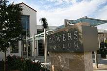
North of downtown is the "Midtown" district along Main St., home to entertainment destinations such as the Bowers Museum, MainPlace Mall, and the Discovery Science Center.
Near the intersection of the Santa Ana Freeway and the Costa Mesa Freeway is the newly designated "Metro East" area, which the city council has envisioned as a secondary mixed-use development district.[20] Currently the area is occupied by several office towers, but little retail or housing. Also on the east side of the city is the Santa Ana Zoo, notable for its collection of monkeys and species from South and Central America.
The southeast end of the city is part of the South Coast Metro area, which is shared with the city of Costa Mesa. South Coast Plaza, a major shopping center, is the primary destination of this area, which also contains several high-rise office and apartment buildings. Yokohama Tire Corporation's United States headquarters are located at 1 MacArthur Place in the South Coast Metro area of Santa Ana, and Banc of California's headquarters will relocate from neighboring Irvine to 3 MacArthur Place, Santa Ana, in 2016.[21][22]
Climate
Santa Ana experiences a Cold semi-arid climate (Köppen: BSk), with hot, dry summers and mild winters with moderate rainfall.[23] The summer months of June to September average a daytime high of 83 °F (28.3 °C) and a nighttime low of 63 °F (17.2 °C). The winter months of December to March average a daytime high of 70 °F (21.1 °C)and a nighttime low of 48 °F (8.9 °C). Rainfall averages about 13.6 in (345 mm) per year, most of which falls from November through April. There are an average of 36 days with measurable precipitation annually.
The record high temperature for Santa Ana was 112 °F (44 °C) on June 14, 1917.[24] The record low temperature was 22 °F (−6 °C) on December 31, 1918, and January 1, 1919.[24] There are an average of 25.6 days with highs of 90 °F (32 °C) or higher and an average of 0.2 days with lows of 32 °F (0 °C) or lower.[24]
The wettest year in Santa Ana was 1941 with 32.36 inches (822 mm) and the driest year was 1961 with 3.55 inches (9.0 cm).[25] The most rainfall in one month was 13.99 inches (35.5 cm) in February 1998.[25] The most rainfall in 24 hours was 4.69 inches (119 mm) on February 16, 1927.[25]
| Climate data for Santa Ana, California | |||||||||||||
|---|---|---|---|---|---|---|---|---|---|---|---|---|---|
| Month | Jan | Feb | Mar | Apr | May | Jun | Jul | Aug | Sep | Oct | Nov | Dec | Year |
| Record high °F (°C) | 96 (36) |
95 (35) |
98 (37) |
104 (40) |
105 (41) |
112 (44) |
110 (43) |
105 (41) |
111 (44) |
106 (41) |
101 (38) |
95 (35) |
112 (44) |
| Average high °F (°C) | 69.9 (21.1) |
70.2 (21.2) |
71.7 (22.1) |
73.9 (23.3) |
75.5 (24.2) |
78.3 (25.7) |
83.1 (28.4) |
84.8 (29.3) |
83.9 (28.8) |
79.6 (26.4) |
74.3 (23.5) |
69.2 (20.7) |
76.2 (24.6) |
| Average low °F (°C) | 47.0 (8.3) |
48.0 (8.9) |
50.0 (10) |
52.7 (11.5) |
56.7 (13.7) |
59.8 (15.4) |
63.2 (17.3) |
63.8 (17.7) |
62.2 (16.8) |
57.9 (14.4) |
51.2 (10.7) |
46.2 (7.9) |
54.9 (12.7) |
| Record low °F (°C) | 22 (−6) |
25 (−4) |
29 (−2) |
31 (−1) |
35 (2) |
39 (4) |
39 (4) |
45 (7) |
40 (4) |
34 (1) |
24 (−4) |
22 (−6) |
22 (−6) |
| Average precipitation inches (mm) | 2.82 (71.6) |
3.39 (86.1) |
2.14 (54.4) |
0.87 (22.1) |
0.21 (5.3) |
0.08 (2) |
0.05 (1.3) |
0.03 (0.8) |
0.21 (5.3) |
0.58 (14.7) |
1.15 (29.2) |
2.10 (53.3) |
13.63 (346.1) |
| Average precipitation days (≥ 0.01 in) | 6.3 | 6.6 | 5.3 | 2.9 | 1.0 | 0.6 | 0.4 | 0.4 | 1.1 | 2.1 | 3.4 | 5.7 | 35.8 |
| Source: NOAA (normals 1981–2010, extremes 1916–present)[24] | |||||||||||||
Demographics
| Historical population | |||
|---|---|---|---|
| Census | Pop. | %± | |
| 1880 | 711 | — | |
| 1890 | 3,628 | 410.3% | |
| 1900 | 4,933 | 36.0% | |
| 1910 | 8,429 | 70.9% | |
| 1920 | 15,485 | 83.7% | |
| 1930 | 30,322 | 95.8% | |
| 1940 | 31,921 | 5.3% | |
| 1950 | 45,533 | 42.6% | |
| 1960 | 100,350 | 120.4% | |
| 1970 | 155,710 | 55.2% | |
| 1980 | 204,023 | 31.0% | |
| 1990 | 293,742 | 44.0% | |
| 2000 | 337,977 | 15.1% | |
| 2010 | 324,528 | −4.0% | |
| Est. 2015 | 335,400 | [26] | 3.4% |
| Racial composition | 2010[28] | 1990[29] | 1970[29] | 1950[29] |
|---|---|---|---|---|
| White | 45.9% | 68.0% | 93.0% | 98.8% |
| —Non-Hispanic whites | 9.2% | 23.1% | 69.8% | n/a |
| Black or African American | 1.5% | 2.6% | 4.3% | 1.0% |
| Hispanic or Latino (of any race) | 78.2% | 65.2% | 24.6% | n/a |
| Asian | 10.5% | 9.7% | 1.0% | 0.1% |
2015
According to the California State Department of Finance, Demographic Research Unit, the current population for 2015 is 335,264. As of 2015, 52,582 residents are enrolled in Santa Ana Unified School District K-12 schools with 11,156 resident students attending Garden Grove schools within Santa Ana and Garden Grove city limits in Garden Grove Unified School District.[30]
According to the Orange County Registrar of Voters, 93,915 residents are registered to vote.[30]
According to the State of California, Employment Development Department, 161,100 residents are a part of the civilian labor force.[30]
2010
The 2010 United States Census[31] reported that Santa Ana had a population of 324,528. The population density was 11,793.3 people per square mile (4,553.4/km²). The racial makeup of Santa Ana was 148,838 (45.9%) White (9.2% Non-Hispanic White), 4,856 (1.5%) African American, 3,260 (1.0%) Native American, 34,138 (10.5%) Asian, 976 (0.3%) Pacific Islander, 120,789 (37.2%) from other races, and 11,671 (3.6%) from two or more races. Hispanic or Latino of any race were 253,928 persons (78.2%).
The census reported that 319,870 people (98.6% of the population) lived in households, 1,415 (0.4%) lived in non-institutionalized group quarters, and 3,243 (1.0%) were institutionalized.
There were 73,174 households, out of which 41,181 (56.3%) had children under the age of 18 living in them, 41,389 (56.6%) were opposite-sex married couples living together, 11,808 (16.1%) had a female householder with no husband present, 6,451 (8.8%) had a male householder with no wife present. There were 4,933 (6.7%) unmarried opposite-sex partnerships, and 556 (0.8%) same-sex married couples or partnerships. 9,254 households (12.6%) were made up of individuals and 3,378 (4.6%) had someone living alone who was 65 years of age or older. The average household size was 4.37. There were 59,648 families (81.5% of all households); the average family size was 4.54.
The age distribution of the population was as follows: 99,678 people (30.7%) under the age of 18, 39,165 people (12.1%) aged 18 to 24, 102,399 people (31.6%) aged 25 to 44, 61,375 people (18.9%) aged 45 to 64, and 21,911 people (6.8%) who were 65 years of age or older. The median age was 29.1 years. For every 100 females there were 104.4 males. For every 100 females age 18 and over, there were 104.6 males.
There were 76,896 housing units at an average density of 2,794.4 per square mile (1,078.9/km²), of which 34,756 (47.5%) were owner-occupied, and 38,418 (52.5%) were occupied by renters. The homeowner vacancy rate was 1.9%; the rental vacancy rate was 4.9%. 154,045 people (47.5% of the population) lived in owner-occupied housing units and 165,825 people (51.1%) lived in rental housing units.
During 2009–2013, Santa Ana had a median household income of $53,335, with 21.5% of the population living below the federal poverty line.[32]
2000
As of the census[33] of 2000, there are 337,977 people, 73,002 households, and 59,788 families residing in the city. The population density is 4,808.2/km² (12,451.9/mi²). There are 74,588 housing units at an average density of 1,061.1/km² (2,748.0/mi²). The racial makeup of the city is 42.73% White, 1.70% African American, 1.19% Native American, 8.81% Asian, 0.34% Pacific Islander, 40.64% from other races, and 4.58% from two or more races. 76.07% of the population are Hispanic or Latino of any race.
There are 73,002 households out of which 53.2% have children under the age of 18 living with them, 60.6% are married couples living together, 13.5% have a female householder with no husband present, and 18.1% are non-families. 12.7% of all households are made up of individuals and 4.6% have someone living alone who is 65 years of age or older. The average household size is 4.55 and the average family size is 4.72.
In the city the population is spread out with 34.2% under the age of 18, 12.8% from 18 to 24, 34.1% from 25 to 44, 13.5% from 45 to 64, and 5.5% who are 65 years of age or older. The median age is 26 years. For every 100 females there are 107.7 males. For every 100 females age 18 and over, there are 108.7 males.
The median income for a household from 2005-2009 was $54,521.[34] The median income for a household in the city is $43,412, and the median income for a family is $41,050. Males have a median income of $23,342 versus $21,637 for females. The per capita income for the city is $12,152. 19.8% of the population and 16.1% of families are below the poverty line. Out of the total population, 24.1% of those under the age of 18 and 10.4% of those 65 and older are living below the poverty line.
Economy
Santa Ana is the corporate headquarters of several companies including Behr Paint, CoreLogic, Corinthian Colleges, First American Corporation, Greenwood & Hall, Ingram Micro, The Orange County Register, SchoolsFirst Federal Credit Union, STEC, TTM Technologies, beverage company Kern's, and Wahoo's Fish Taco. It also houses major regional headquarters for the Xerox corporation, Ultimate Software, and T-Mobile. Nonprofits based in Santa Ana include Open Doors.
One of Santa Ana's most notable businesses is the Rickenbacker musical instrument company, whose electric guitars and bass guitars earned fame in the hands of many rock and roll legends.
Then Glenn L. Martin Company, a precursor to Lockheed Martin, was founded in Santa Ana in 1912 before merging with the Wright Company in 1916.
In recent years, the nearby city of Irvine has outpaced Santa Ana in commercial growth, with the Irvine Business District located near John Wayne Airport. To compete with this, Santa Ana has approved commercial projects in the South Coast Metro area, as well as the "Metro East" development, located at the confluence of the Santa Ana Freeway and the Costa Mesa Freeway.
The Historic South Main Business District contains many older retail shops and other small businesses. It extends from downtown Santa Ana southwards on Main Street to the South Coast Metro area.
Santa Ana is part of a metropolitan area which includes Los Angeles and Long Beach. When it comes to gross metropolitan product of U.S. metro areas, Los Angeles-Long Beach-Santa Ana, CA is ranked number two in 2013 with a GMP of $792.2 billion. When gross domestic product (GDP) and gross metropolitan product (GMP) for country or metro area were compared, Los Angeles-Long Beach-Santa Ana, CA ranked number 20 for their 2013 numbers. The ranking for Santa Ana was higher than both Saudi Arabia and Switzerland, which ranked 21 and 22 respectively. The estimated annual growth rate of United States metro area economies from 2013-2020 is 2.9 percent with $686.5 billion in 2013 and an estimated $838.2 billion in 2020.[35]
According to real gross metropolitan product and employment growth rates from 2013 to 2015, the Los Angeles-Long Beach-Santa Ana, CA metropolitan area ranked number two according to its 2013 GMP. Its percent change in employment was 1.7 in 2013, 1.1 in 2014, and 1.5 in 2015 and its percent change in real GMP 2.7 in 2013, 1.8 in 2014, and 2.6 in 2015. Real gross state and metropolitan output in terms of annual growth percentages in the metropolitan area of Los Angeles-Long Beach-Santa Ana, CA was 2.3 in 2014 and 3.3 in 2015. In terms of end of the year value, the metro area unemployment rates in Los Angeles-Long Beach-Santa Ana, CA were 9.6 percent in 2012, 8.5 percent in 2013, 7.6 percent in 2014, and 7.0 percent in 2015, and will be approximately 6.7 percent in 2016. The unemployment growth rate from 2012 to 2016 is negative 2.9 percent.[35]
There was a recession in the last 2000s (decade) and the expected year for return to peak employment for the Los Angeles-Long Beach-Santa Ana, CA area is 2015. The pre-recession peak year was 2007. Due to the recession, 519.3 thousands of jobs were lost, this was a decline percent was 9.[35] According to the Employment Development Department, the current unemployment rate for 2015 is 5 percent.[30]
When it comes to building activity, the total valuation of all construction comes up to be $155,402,851.[30]
Top employers
According to the City's 2010 Comprehensive Annual Financial Report,[36] the top employers in the city are:
| # | Employer | # of employees |
|---|---|---|
| 1 | County of Orange | 15,390 |
| 2 | Ingram Micro | 4,000 |
| 3 | Rancho Santiago Community College District | 2,300 |
| 4 | United States Postal Service | 2,000 |
| 5 | Tenet Healthcare | 1,500 |
| 6 | Freedom Communications | 900 |
| 6 | First American | 900 |
| 8 | Corinthian Colleges | 858 |
| 9 | California Department of Mental Health | 800 |
| 10 | United Building Services | 800 |
Other large employers include Western Medical Center, TTM Technologies, Integrated Healthcare Holdings Inc, Universal Services of America, MSC Software Corp, and Sterns Learning Inc.[34]
Arts and culture
Recreation and attractions
Santa Ana has a number of parks.[37] Disneyland and Knott's Berry Farm amusement parks are located northwest of Santa Ana, several kilometers away. Beaches are located around 20 minutes to the south, accessible by the 55 freeway. Huntington Beach and Newport Beach as well as other coastal communities offer shopping, dining, boating, swimming and surfing.
Sites of interest
- Artist Village and Civic Center (See Downtown Santa Ana Historic Districts).
- Bowers Museum - Art and History museum started in the 1930s with a large collection of fine art and artifacts from around the world and several traveling exhibits each year.
- CSUF Grand Central Art Center - At the heart of the Artist Village in Santa Ana.
- Delhi Park and El Salvador Park (Artesia Pilar Neighborhood)
- Discovery Science Center.
- Downtown National Register District.
- Downtown Santa Ana Historic Districts.
- El Centro Cultural de México.
- Main Place Mall opened in 1987.
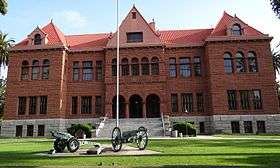
- Old Orange County Courthouse.
- Santa Ana Civic Center.
- Santa Ana College, part of the Rancho Santiago Community College District.
- Santa Ana Zoo, built in 1960.
- Greenville, a former rural part of Santa Ana, has buildings over a century old, but industrial complexes have replaced the agricultural fields once surrounding the town.
Santa Ana has several wall paintings and murals depicting local history, community events and cultural diversity in Orange County.
Notable locations
- Riverview Golf Course
- Willowick Municipal Golf Course
- Pacific Electric Sub-Station No. 14
- Southern (D), Builders Exchange Building
- Ronald W Reagan Federal Courthouse
- Newhope Branch Santa Ana Public Library
- Dr. Willella Howe-Waffle House
- Bowers Museum of Cultural Art
- Santa Ana City Hall
- Santa Ana Public Library
- Santa Ana Regional Transportation Center
- McFadden Branch Santa Ana Public Learning Center
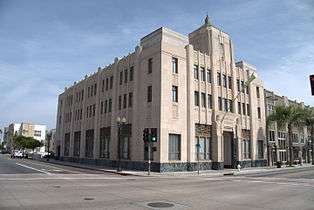
- Santora Building
- Heritage Museum of Orange County (Kellogg House)
- Old Orange County Courthouse
- Rankin Building
- Dexter's Chomp House
- Zawiya Perspective
Sports

Santa Ana has highly competitive high school and collegiate sports teams playing at Santa Ana Stadium and the recently opened Santa Ana Unified School District Sports Complex Stadium. Mater Dei High School has one of the most successful and reputable American football programs in the country.[38] The Dons of Santa Ana College are one of the most successful soccer teams in the state of California, and is a frequent top finisher, statewide.[39] In 2008, the Dons clinched their fifteenth consecutive Orange Empire Conference title.[39] The college is also known for its historically successful baseball teams,[40] and for producing former Texas Rangers and current Los Angeles Angels pitcher C.J. Wilson.
Government
Santa Ana utilizes a mayor-council form of government. The council consists of six members who are elected by the populace of the city. Each member serves for four years and can serve a total of three terms. A mayor pro tem is elected by the council members from within the council.[41]
Mayor Miguel Pulido is currently under investigation by the city attorney for a property swap involving a city contractor, in which the mayor ended up profiting $200,000.[42] The mayor voted for a $1.4-million city contract with an auto parts firm, NAPA Orange County, just over a year after he bought a home from the firm's owner for $230,000 less than fair market value.[43]
Politics
Santa Ana is one of a few cities in Orange County where Democratic Party registration outnumbers that of the Republican Party.[44] In the 2008 Presidential Election, Barack Obama defeated John McCain in the city by a margin of 20,357 votes, 65% to 32%.[45] This was despite Obama losing to fellow Democrat Hillary Clinton in the city during the Democratic Primary. Despite the city's high percentage of Democrats, however, the city tends to vote conservatively on social issues, much like the rest of northern Orange County. It voted Yes on California Proposition 8 by 61.9%, above the county's average of 57.7%. On California Proposition 4, which would have amended the California Constitution to require minors to notify their parents before having an abortion, Santa Ana voted in favor of the measure by 62.0%, much higher than the county as a whole, which voted in favor of the measure by only 54.3%.[46]
In the California State Legislature, Santa Ana is in the 34th Senate District, represented by Republican Janet Nguyen, and in the 69th Assembly District, represented by Democrat Tom Daly.[47]
In the United States House of Representatives, Santa Ana is split between California's 46th congressional district, represented by Democrat Loretta Sanchez, and California's 48th congressional district, represented by Republican Dana Rohrabacher.[48]
The Consulate-General of Mexico in Santa Ana is located on 828 North Broadway Street.[49] The Consulate-General of El Salvador in Santa Ana is located in Suite 103 at 840 North Grand Avenue.[50]
Education

Santa Ana Unified School District includes thirty-seven K–5 elementary schools, nine 6–8 intermediate schools, eight 9–12 high schools, five special schools, and one charter school. Some elementary schools are: John Adams Elementary School, Manuel Esqueda Elementary School, Diamond Elementary School. The school district provides an online accountability report card.[51] The Garden Grove Unified School District also includes some schools within Santa Ana.
Santa Ana Unified School District's public high schools include Valley High School (Santa Ana), Middle College High School, Santa Ana High School, Saddleback High School, Century High School, newly opened Segerstrom Fundamental High School and Godinez Fundamental High School, and other public schools in the area, along with the Orange County High School of the Arts in the midtown district.
The Roman Catholic Diocese operates Mater Dei High School. The Diocese also operates several K–8 schools in Santa Ana, including School of Our Lady, Saint Anne, Saint Barbara, and Saint Joseph. (Immaculate Heart Of Mary And Our Lady Of the Pillar schools were closed in 2005 and merged into the School of Our Lady, which is located at Immaculate Heart of Mary Parish.[52]
The city is home to Santa Ana College, a two-year public community college, as well as California Coast University, and the Orange County branch of the Art Institute of California. Taft Law School a correspondence law school is also based in Santa Ana. Trinity Law School is a Christian, CBE-accredited law school that is the only California campus of the Trinity International University system of schools. Detective Training Institute is a correspondence/distance learning institution that offers private investigator diplomas and is approved to operate by the Bureau for Private Postsecondary Education. Career Networks Institute College is a post secondary occupational learning center for allied health is also based in the city.
Infrastructure
Transportation
A few freeways run through Santa Ana, connecting the city to other areas in Orange County, the Greater Los Angeles Area, and beyond. The Santa Ana Freeway (Interstate 5) heads north to Los Angeles, and south towards Southern Orange County and San Diego. The Garden Grove Freeway (State Route 22) runs along near Santa Ana's northern border, connecting Long Beach to the west and the City of Orange to the east. The Costa Mesa Freeway (State Route 55) travels south to Costa Mesa; and then north to the Riverside Freeway (State Route 91), providing a connection to Riverside.
Amtrak, the national passenger rail system, provides service to Santa Ana several times on weekdays with less frequent service on weekends. It operates its Pacific Surfliner between San Diego to the south and either Los Angeles or Paso Robles to the north (see Santa Ana Regional Transportation Center). Greyhound USA is the largest bus transportation service in Santa Ana. Greyhound serves the continental United States and Canada. The bus lines Crucero, Intercalifornias, and others serve all points into Mexico.
Santa Ana is also served by Metrolink's Orange County Line (Oceanside to Union Station), and Inland Empire-Orange County Line (San Bernardino to San Juan Capistrano).
Santa Ana is in the preliminary stages of implementing a street car system that will connect the Santa Ana Train station to Downtown Santa Ana.[53]
Public transit bus service is available via the Orange County Transportation Authority (OCTA).
John Wayne Airport is located at 18601 Airport Way Santa Ana, CA 92707. The IATA code for the airport is SNA.
Utilities
Electricity for the city is provided by Southern California Edison. The Southern California Gas Company provides natural gas service. Phone and cable television is provided by AT&T.
Emergency service
Law enforcement is provided by the Santa Ana Police Department from three stations throughout the city.[54] The department includes five canine units,[55] an 11 officer equestrian unit and a 37-member SWAT team.[56] The city shares a helicopter with the cities of Costa Mesa and Newport Beach via the Airborne Law Enforcement (ABLE) program.[57]
In March 2012, the city disbanded its municipal fire department which had provided fire protection for 128 years[58] and contracted with the Orange County Fire Authority.
Notable people
See also
- List of California communities with Hispanic majority populations
- Rancho Cañón de Santa Ana (Santa Ana Canyon Ranch)
- Rancho San Juan Cajón de Santa Ana
- Rancho Santiago de Santa Ana
- Santora Building
- Santa Ana (Amtrak station)
- Santa Ana Canyon
- Santa Ana Civic Center
- Santa Ana Freeway
- Santa Ana Heights
- Santa Ana Mountains
- Santa Ana River
- Santa Ana Stadium
- Santa Ana Watershed
- Santa Ana Valley
- Santa Ana wind
- Santiago Creek
- Yost Theater
References
- ↑ "City of Santa Ana Vitals & Statistics" (PDF). City of Santa Ana. Retrieved February 6, 2015.
- ↑ "California Cities by Incorporation Date" (Word). California Association of Local Agency Formation Commissions. Retrieved August 25, 2014.
- ↑ "Elected Officials". City of Santa Ana. Retrieved October 16, 2014.
- ↑ "2010 Census U.S. Gazetteer Files – Places – California". United States Census Bureau.
- 1 2 "Santa Ana". Geographic Names Information System. United States Geological Survey. Retrieved October 12, 2014.
- ↑ "Table 1: Annual Estimates of the Population for Incorporated Places Over 100,000, Ranked by July 1, 2007 Population: April 1, 2000 to July 1, 2007". 2007 Population Estimates. United States Census Bureau, Population Division. 2008-07-10. Archived from the original (CSV) on 2008-07-23. Retrieved 2008-07-10.
- ↑ https://www.census.gov/popest/data/cities/totals/2014/index.html
- ↑ "ZIP Code(tm) Lookup". United States Postal Service. Retrieved November 12, 2014.
- ↑ Beth Greenfield. "#4 Santa Ana, Calif. - In Photos: America's Safest Cities". Forbes.
- ↑ The Santa Ana Winds. Atmos.ucla.edu. Retrieved on 2013-09-06.
- ↑ Munro, Pamela, et al. Yaara' Shiraaw'ax 'Eyooshiraaw'a. Now You're Speaking Our Language: Gabrielino/Tongva/Fernandeño. Lulu.com: 2008.
- ↑ Staff (May 12, 2015). "A look at the trains that built the O.C. coast". Los Angeles Times. Retrieved 12 January 2016.
- ↑ "Pacific Electric Santa Ana Line". erha.org.
- ↑ Featuring Historical Information of Santa Ana. Santa Ana History. Retrieved on 2013-09-06.
- ↑ Historic California Posts: Santa Ana Army Air Base. Militarymuseum.org. Retrieved on 2013-09-06.
- ↑ Eng, Lily; Schwartz, Bob (February 26, 1991). "City's Latinos on the Grow : Majority: Santa Ana's Hispanics make up 65% of the population and have recorded solid gains, but some still say they are ignored by City Hall.". Los Angeles Times. Retrieved 19 March 2016.
- ↑ Yost Theater | Soundcheck. Soundcheck.freedomblogging.com. Retrieved on 2013-09-06.
- ↑ "US Gazetteer files: 2010, 2000, and 1990". United States Census Bureau. 2011-02-12. Retrieved 2011-04-23.
- ↑ Featuring Historical Information of Santa Ana. Santa Ana History. Retrieved on 2013-09-06.
- ↑ Metro East Mixed Use Overlay Zone. Santa-ana.org. Retrieved on 2013-09-06.
- ↑ "Banc of California to Purchase New Corporate Headquarters". Business Wire. Retrieved September 12, 2016.
- ↑ "What it Means to be California's Bank". LA Progressive. Retrieved September 12, 2016.
- ↑ "Climate: Santa Ana". climate-data.org. Retrieved 23 August 2016.
- 1 2 3 4 "NOWData - NOAA Online Weather Data". National Oceanic and Atmospheric Administration. Retrieved June 20, 2013.
- 1 2 3 "Santa Ana Fire STN, California". Western Regional Climate Center. Retrieved June 20, 2013.
- ↑ "Annual Estimates of the Resident Population for Incorporated Places: April 1, 2010 to July 1, 2015". Retrieved July 2, 2016.
- ↑ "Census of Population and Housing". Census.gov. Retrieved June 4, 2015.
- ↑ "Santa Ana (city), California". State & County QuickFacts. U.S. Census Bureau.
- 1 2 3 "Race and Hispanic Origin for Selected Cities and Other Places: Earliest Census to 1990". U.S. Census Bureau.
- 1 2 3 4 5 City of Santa Ana http://www.ci.santa-ana.ca.us/facts/. Retrieved 7 May 2015. Missing or empty
|title=(help) - ↑ "2010 Census Interactive Population Search: CA - Santa Ana city". U.S. Census Bureau. Retrieved July 12, 2014.
- ↑ "Santa Ana (city) QuickFacts from the US Census Bureau". census.gov.
- ↑ "American FactFinder". United States Census Bureau. Retrieved 2008-01-31.
- 1 2 "Facts and Figures". City of Santa Ana. Retrieved 23 April 2015.
- 1 2 3 (PDF) http://usmayors.org/metroeconomies/2014/06/report.pdf. Retrieved 7 May 2015. Missing or empty
|title=(help) - ↑ City of Santa Ana 2010 Comprehensive Annual Financial Report Retrieved 2010-09-26
- ↑ Parks and Recreation, City of Santa Ana. Ci.santa-ana.ca.us. Retrieved on 2013-09-06.
- ↑ http://www.materdei.org/apps/pages/index.jsp?uREC_ID=66342&type=d&pREC_ID=107071
- 1 2 http://www.sacdons.com/sports/msoc/history/championships
- ↑ http://www.sacdons.com/sports/bsb/history/championships
- ↑ "Mayor and City Council". City of Santa Ana. Retrieved March 7, 2012.
- ↑ "Santa Ana Council Meets Privately on Pulido Property Swap". Voice of OC. Retrieved January 15, 2014.
- ↑ "Santa Ana Mayor's Property Swap Raises Questions". Voice of OC. Retrieved January 15, 2014.
- ↑ Archived February 23, 2012, at the Wayback Machine.
- ↑ "Santa Ana election results". The Orange County Register.
- ↑ Archived October 18, 2012, at the Wayback Machine.
- ↑ "Statewide Database". UC Regents. Retrieved November 28, 2014.
- ↑ "Communities of Interest - City". California Citizens Redistricting Commission. Retrieved September 27, 2014.
- ↑ "sobre." Consulate-General of Mexico in Santa Ana. Retrieved on February 1, 2009.
- ↑ "Norte América." Consulate-General of El Salvador in Miami. Retrieved on February 1, 2009.
- ↑ Archived March 5, 2012, at the Wayback Machine.
- ↑ "School of Our Lady". schoolofourlady.org.
- ↑ "Santa Ana streetcar plan moves forward". The Orange County Register.
- ↑ "Santa Ana Police Department". City of Santa Ana. Retrieved March 7, 2012.
- ↑ "Canine Unit". City of Santa Ana. Retrieved March 7, 2012.
- ↑ "Honor Guard, Mounted Unit & SWAT". City of Santa Ana. Retrieved March 7, 2012.
- ↑ "Airborne Law Enforcement Services". City of Santa Ana. Retrieved March 7, 2012.
- ↑ Sewell, Abby (March 6, 2012). "A proud tradition extinguished". Los Angeles Times. section A, p. 1 and 8.
External links
- Official website
- Santa Ana Police Department
- Santa Ana Public Library
- Santa Ana Historical Preservation Society
- Orange County Business Council (Chamber of Commerce)
- Santa Ana Chamber of Commerce
 |
Garden Grove | Anaheim | Orange | |
| Westminster | |
Tustin | ||
| ||||
| | ||||
| Fountain Valley | Costa Mesa | Irvine |