Rancho Cucamonga, California
| Rancho Cucamonga, California | |||
|---|---|---|---|
| City | |||
| City of Rancho Cucamonga | |||
|
Downtown Rancho Cucamonga in December 2008 | |||
| |||
| Motto: A World Class Community | |||
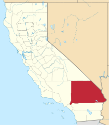
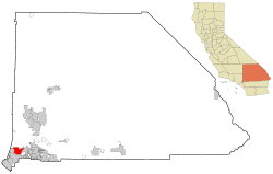 Location of Rancho Cucamonga in San Bernardino County | |||
 Rancho Cucamonga, California Location in the United States | |||
| Coordinates: 34°7′24″N 117°34′46″W / 34.12333°N 117.57944°WCoordinates: 34°7′24″N 117°34′46″W / 34.12333°N 117.57944°W | |||
| Country |
| ||
| State |
| ||
| County |
| ||
| Incorporated (city) | November 30, 1977[1] | ||
| Government | |||
| • Type | Council-Manager | ||
| • City council[2] |
Mayor L. Dennis Michael Sam Spagnolo William J. Alexander Lynne Kennedy Diane Williams | ||
| • City clerk | Janice C. Reynolds[3] | ||
| • City treasurer | James C. Frost[4] | ||
| • City manager | [5] | ||
| Area[6] | |||
| • Total | 39.871 sq mi (103.263 km2) | ||
| • Land | 39.851 sq mi (103.212 km2) | ||
| • Water | 0.0200 sq mi (0.051 km2) 0.05% | ||
| Elevation[7] | 1,207 ft (368 m) | ||
| Population (April 1, 2010)[8] | |||
| • Total | 165,269 | ||
| • Estimate (2014)[9] | 174,305 | ||
| • Rank |
3rd in San Bernardino County 27th in California | ||
| • Density | 4,100/sq mi (1,600/km2) | ||
| Time zone | PST (UTC-8) | ||
| • Summer (DST) | PDT (UTC-7) | ||
| ZIP Code | 91701, 91729, 91730, 91737, 91739[10] | ||
| Area code(s) | 909[11] | ||
| FIPS code | 06-59451 | ||
| GNIS feature ID | 1667908 | ||
| Website |
www | ||

Rancho Cucamonga is a suburban city situated at the foothills of the San Gabriel Mountains in San Bernardino County, California. It is located 37 miles (60 km)[12] east of Downtown Los Angeles. The city had a population of 165,269[13] in 2010 and an estimated population of 174,305[9] in 2014. The city experiences an average of 287 sunny days per year, compared to a national average of 205 days.[14] Its climate is classified as warm Mediterranean, or Csa, under the Köppen climate classification system.[15] The city's seal, which centers on a cluster of grapes, alludes to the city's agricultural history and intimate connections to wine-making.[16]
The city's favorable location and host of public amenities have earned it numerous distinctions. Notably, Money Magazine ranked Rancho Cucamonga 42nd on its "Best Places to Live" list in 2006.[17] In addition, Insider Magazine established one Rancho Cucamonga neighborhood as the 13th richest neighborhood in Southern California.[18] All of the city's four public high schools earned the Silver distinction in a 2015 ranking of the nation's high schools by U.S. News & World Report.[19] The city's proximity to major transportation hubs, airports, and highways has attracted the business of the nation's largest corporations including Coca-Cola, Nong Shim, Frito-Lay, and Amphastar Pharmaceuticals.[20]
History
Rancho Cucamonga's first settlers were Native American. By 1200 A.D., Kukamongan Native Americans had established a village settlement in the area around present-day Red Hill, near the city's western border. Kukamonga derives its name from a Native-American word meaning "sandy place."[21] Anthropologists have determined that this cluster of settlers likely belonged to the Gabrielino culture, at one time one of the largest concentrations of Native American peoples on the North American continent.[22] In the 18th Century, following an expedition led by Gaspar de Portola, the land was incorporated into the Mission System established by Father Junipera Serra and his group of soldiers and Franciscan Monks.

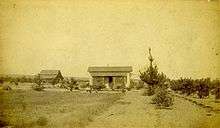
After a half-century of political jockeying in the region, the land finally came under the control of Juan Bautista Alvarado, governor of Mexico. On March 3, 1839, Alvarado granted 13,000 acres of land in the area called Cucamonga to Tubercio Tapia, a first-generation Spanish native of Los Angeles, successful merchant, and notorious smuggler.[22][23] Tapia went on to establish the first winery in California on his newly deeded land.[21][22][24][25] Rancho Cucamonga was purchased by John Rains and his wife in 1858. The Rains family's home, Casa de Rancho Cucamonga, was completed in 1860 and now appears on the National Register of Historic Places.[21][26]
During the ensuing years the town prospered and grew. In 1887, irrigation tunnels were dug into Cucamonga Canyon by Chinese laborers and the Santa Fe Railroad was extended through the area. Among the town's economic mainstays was agriculture, including olives, peaches, citrus, and, most notably, vineyards.[21] In 1913, the Pacific Electric Railway was extended through Rancho Cucamonga in an effort to improve crop transportation. Several landmarks in existence today pay tribute to the city's multicultural founding. In particular, Our Lady of Mt. Carmel[27] remains as a relic of the area's Mexican agriculture laborers while the Chinatown House[28] stands as a reminder of the Chinese immigrants who labored in constructing the area's infrastructure.[22]
In 1977, the unincorporated communities of Alta Loma, Cucamonga, and Etiwanda voted to incorporate, forming the city of Rancho Cucamonga.[29]
Grapeland
The former community of Grapeland, first settled in 1869, lay roughly between today's Victoria Groves Park and Central Park. There was a schoolhouse which also doubled as a church. In 1890 an irrigation district was formed and $200,000 in bonds were sold to pay for improvements. The Sierra Vista reservoir was built in 1886-87 by J.L. Scofield as the focal point of a network of irrigation pipes. The system was unused, however, because the bond issue was declared illegal. "Orchards and vineyards began to die," The Daily Report newspaper reported in a retrospective. "Residents moved out. The post office closed in 1905. Homes, buildings were destroyed or abandoned." The reservoir remained unused until 1956, when the Fontana Union Water Company filled it with 5 million gallons of water. The local school district was merged with the Etiwanda district in 1901. In 1957 the settlement was practically deserted, but there were still rabbit-proof stone walls marking boundaries of previous citrus orchards.[30]
Geography
Rancho Cucamonga is part of the Inland Empire and San Bernardino County, a region that lies inland from the pacific coast and directly east of Los Angeles county.Rancho Cucamonga is located about 37 miles (60 km) east of Los Angeles, bordered by Upland to its West, Ontario to its South, the San Gabriel Mountains to its North and I-15 and Fontana to its East.[12] The city sits atop an alluvial plain and views of Cucamonga Peak, one of the tallest peaks of the San Gabriel Mountains, are available from all points throughout the city.[31] The city has a total area of 39.9 square miles (103 km2), 99.95% of which is land and 0.05% water.[32]
Climate
The city's climate is classified as warm Mediterranean, or Csa, under the Köppen climate classification system.[15] Yearly precipitation is 15.3 inches and the city experiences an average of 287 sunny days per year, compared to a national average of 205 days.[14]
Demographics
| Historical population | |||
|---|---|---|---|
| Census | Pop. | %± | |
| 1980 | 55,250 | — | |
| 1990 | 101,409 | 83.5% | |
| 2000 | 127,743 | 26.0% | |
| 2010 | 165,269 | 29.4% | |
| Est. 2015 | 175,236 | [33] | 6.0% |
The city's estimated 2014 population was 174,305,[9] a 36% increase since 2000.
2010
The 2010 United States Census[13] reported that Rancho Cucamonga had a population of 165,269. The population density was 4,145.2 people per square mile (1,600.5/km²). The racial makeup of Rancho Cucamonga was 102,401 (62.0%) White (42.7% Non-Hispanic White), 15,246 (9.2%) African American, 1,134 (0.7%) Native American, 17,208 (10.4%) Asian, 443 (0.3%) Pacific Islander, 19,878 (12.0%) from other races, and 8,959 (5.4%) from two or more races. There were 57,688 residents of Hispanic or Latino ancestry, of any race (34.9%).
The census reported that 162,145 people (98.1% of the population) lived in households, 136 (0.1%) lived in non-institutionalized group quarters, and 2,988 (1.8%) were institutionalized.[35]
Out of a total of 54,383 households, 23,055 (42.4%) had children under the age of 18 living in them, 30,533 (56.1%) were opposite-sex married couples living together, 7,514 (13.8%) had a female householder with no husband present, and 3,257 (6.0%) had a male householder with no wife present, as well as 2,995 (5.5%) unmarried opposite-sex partnerships and 425 (0.8%) same-sex married couples or partnerships. 9,956 households (18.3%) were made up of individuals and 2,679 (4.9%) had someone living alone who was 65 years of age or older. The average household size was 2.98. Over the 41,304 families (76.0% of all households), the average family size was 2.90.[36]
The age distribution of the city was as follows: 42,550 people (25.7%) under the age of 18, 17,365 people (10.5%) aged 18 to 24, 48,600 people (29.4%) aged 25 to 44, 43,710 people (26.4%) aged 45 to 64, and 13,044 people (7.9%) who were 65 years of age or older. The median age was 34.5 years. For every 100 females there were 97.6 males. For every 100 females age 18 and over, there were 95.2 males.
There were 56,618 housing units at an average density of 1,420.1 per square mile (548.3/km²), of which 35,250 (64.8%) were owner-occupied, and 19,133 (35.2%) were occupied by renters. The homeowner vacancy rate was 1.6%; the rental vacancy rate was 5.2%. 110,570 people (66.9% of the population) lived in owner-occupied housing units and 51,575 people (31.2%) lived in rental housing units.
During 2009–2013, Rancho Cucamonga had a median household income of $77,835, with 6.9% of the population living below the federal poverty line.[37]
2000
As of the census of 2000, there were 127,743 people, 40,863 households, and 31,832 families residing in the city. The population density was 1,317.0/km² (3,411.4/mi²). There were 42,134 housing units at an average density of 434.4/km² (1,125.2/mi²). The racial makeup of the city was 66.53% White, 9.00% Asian, 0.67% Native American, 5.99% African American, 0.27% Pacific Islander, 13.25% from other races, and 5.41% from a biracial or multiracial background. Hispanic or Latino of any race were 27.78% of the population.
There are 40,863 households, of which 44.7% have children under the age of 18. 60.2% of households consist of a married couple living together. 12.8% have a female householder with no husband present. 22.1% were non-families. 16.8% of all households are single-person and 4.1% have a person of 65 years of age or older. The average household size was 3.04 and the average family size was 3.44.
In the city, the population spread is as follows: 29.9% are under the age of 18, 9.9% are from 18 to 24, 33.2% are from 25 to 44, 21.0% are from 45 to 64, and 6.1% are 65 years of age or older. The median age is 32 years. For every 100 females there were 100.1 males. For every 100 females age 18 and over, there were 98.0 males.
The median income for a household in the city was $78,428 and the median income for a family was $91,240. Males had a median income of $50,288 versus $40,952 for females. The per capita income for the city was $23,702. About 4.9% of families and 7.1% of the population were below the poverty line, including 7.6% of those under age 18 and 7.3% of those age 65 or over.
Economy
In 2006, Money magazine ranked the city 42nd on its "Best Places to Live" list.[17] Business Insider magazine ranked Haven View Estates, one of the city's many gated communities, 13th on its list of "The 27 Richest Neighborhoods in Southern California", just behind the Los Angeles neighborhood of Bel Air, which ranked 12th.[18]

While most of the city's land area is devoted to residential areas, Rancho Cucamonga, like its neighbors Ontario and Fontana, is a major center for the logistics industry in Southern California. This is due to its proximity to two interstate highways and Ontario International Airport, and the space afforded by the large tracts of former agricultural land in the southern section of the city.[38]
In the area around Milliken Avenue, between Archibald and Etiwanda Avenues, Foothill Boulevard, and Fourth Street, about seven square miles of land are primarily occupied by numerous massive distribution centers, and even more, smaller manufacturing companies. This area is ringed by office parks, mostly along Haven Avenue, and shopping strips, such as the Terra Vista Town Center (part of a nearly two-square-mile master-planned community in the center of the city), and malls, such as Victoria Gardens, and the Ontario Mills, across Fourth Street in Ontario.[39]
The city is also home to Tamco Steel, which runs the only steel mini-mill in California. This mill recycles ferrous scrap, such as junked cars and appliances, to produce rebar.[40]
The city hosts LoanMart Field, (formerly known as The Epicenter), a minor-league baseball stadium, home of the Rancho Cucamonga Quakes. The Quakes' mascot, Tremor, is a "Rallysaurus".
Victoria Gardens
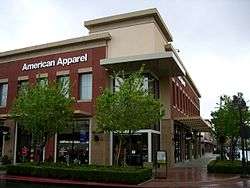
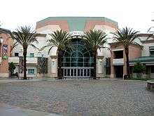
The "Victoria Gardens lifestyle center", built in the eastern end of the city, is located at the intersection of Foothill and Day Creek Boulevards. Since the city had never developed a traditional commercial downtown like neighboring cities Ontario and Upland had, efforts were made in the design of Victoria Gardens to bring elements of more traditional and urban town design to what had historically been a suburban city. While retaining many characteristics of traditional shopping malls, such as large anchor stores, a food court, and vast parking lots and garages, the smaller stores are arranged as city blocks in a grid of two-lane streets, featuring lush landscaping and metered "teaser parking" in front of the stores, which open onto the sidewalk. There are two "Main Streets", which run from west to east across the center. Running from north to south between them is a pedestrian axis leading from one of the Macy's anchor stores, through a "town square" between a pair of mixed-use office buildings, to the Victoria Gardens Cultural Center, which contains a 570-seat theater and a city library. There are restaurants throughout the center, both well-known chains and unique eateries including California Pizza Kitchen, N7 Creamery, Fleming's, Gyu-Kaku Japanese BBQ Dining, Harry's Pacific Grill, Johnny Rockets, King's Fish House, Lucille's BBQ, P.F. Chang's China Bistro, Richie's Diner, T.G.I. Friday's, and Yard House. The center features a 12 screen AMC Theatre. Foothills Crossing is a shopping center located at Foothill Blvd just west of Interstate 15.
Across the street from Victoria Gardens, Rancho Cucamonga also boasts Southern California's only Bass Pro Shops Outdoor World superstore.
Top employers
According to the City's 2011 Comprehensive Annual Financial Report, [41] the top employers in the city are:
| # | Employer | # of employees |
|---|---|---|
| 1 | Etiwanda School District | 1,312 |
| 2 | Chaffey College | 1,300 |
| 3 | Amphastar Pharmaceuticals | 999 |
| 4 | City of Rancho Cucamonga | 880 |
| 5 | Alta Loma School District | 783 |
| 6 | Macy's | 750 |
| 7 | Central School District | 680 |
| 8 | West Valley Detention Center | 668 |
| 9 | Big Lots | 521 |
| 10 | Mercury Insurance Company | 509 |
Government
Local government
Rancho Cucamonga is a General Law City, incorporated in 1977 under the "Council-Manager" form of local government. The four-member Council, plus the Mayor, City Clerk, and City Treasurer, are all elected at-large by the voters of the city. The Council then appoints the City Manager, who acts as the administrative head of the city government, and is responsible for the day-to-day operations, code enforcement, and the fiscal soundness of the municipal government. The council itself serves as a local legislative body.
L. Dennis Michael has been the city's mayor since 2011, with John Gillison as the city manager.
According to a city Comprehensive Annual Financial Report, the city's various funds had $278.3 million in Revenues, $243.6 million in expenditures, $1,400.7 million in total assets, $492.1 million in total liabilities, and $583.3 million in cash and investments.[42]

Politics
In the California State Legislature, Rancho Cucamonga is in the 23rd Senate District, represented by Republican Mike Morrell, and in the 40th Assembly District, represented by Republican Marc Steinorth.[43]
In the United States House of Representatives, Rancho Cucamonga is in California's 31st congressional district, represented by Democrat Pete Aguilar.[44]
In 2005, the non-partisan Bay Area Center for Voting Research ranked Rancho Cucamonga as the 28th most conservative city in the United States.[45]
Law enforcement
Since incorporation in 1977, law enforcement services in Rancho Cucamonga City have been provided through a contract with the San Bernardino County Sheriff's Department.[46]
Rancho Cucamonga is also home to the Foothill Communities San Bernardino County Courthouse, which is housed in a building adjacent to the Rancho Cucamonga Civic Center, in a government complex located at Haven Avenue and Civic Center Drive in the city. The Civic Center houses the Rancho Cucamonga city hall, the city police department, and other local government offices.
Education


Schools
Rancho Cucamonga has multiple public K-12 schools, operating under several different school districts, within its borders: Alta Loma School District, Central School District, Cucamonga School District, Etiwanda School District, and Chaffey Joint Union High School District. In addition to these, Rancho Cucamonga is the home to Chaffey College and satellite campuses of the University of La Verne, Cambridge College, University of Redlands, Everest College, and University of Phoenix, as well as the automotive trade school, Universal Technical Institute. Its newest addition is the private school Upland Christian Academy.
High Schools
Libraries
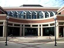
The city of Rancho Cucamonga has two public libraries, with a combined total of over 200,000 volumes. The library at 7368 Archibald Avenue opened in 1994 and was remodeled in the summer of 2008. The Paul A. Biane library at 12505 Cultural Center Drive at the Victoria Gardens Cultural Center opened in August 2006. In 2013, the Rancho Cucamonga Public Library was a recipient of the National Medal for Museum and Library Services, the nation's highest honor that can be bestowed on a Library or Museum.[47]
Infrastructure
Rancho Cucamonga's location at the base of the San Gabriel Mountains has necessitated the use of numerous control channels and basins to reduce the seasonal flood danger from the several streams descending from the range. In past years, some of the city's roads were known for flooding. Hermosa Avenue, in particular, now features many high curbs and extra-large storm drain grates to reduce flooding.
Transportation
Rancho Cucamonga is served by Omnitrans Bus Service, Metrolink Train Service, and nearby Ontario International Airport. Interstate 15 and the relatively new 210 freeway extension run through Rancho Cucamonga as well as the historic U.S. Route 66. I-15 sits atop an elevated berm, and cuts a curve through the southeastern part of the city, isolating a mostly industrial area, a small shopping center, and several housing tracts from the larger part of the city. It then levels out toward the north, and forms part of the northeastern border with neighboring Fontana, before entering the Cajon Pass through the San Gabriel Mountains. Route 210 runs nearly straight east-west through the northern part of the city, roughly bisecting the residential communities of Alta Loma and Etiwanda. The western section of the freeway, as it passes through the city, sits in a trench, but east of Day Creek Boulevard, the freeway levels out, then becomes elevated as it passes the San Sevaine creek flood control basins, before passing into Fontana at the angled interchange with I-15.
Utilities
Rancho Cucamonga receives natural gas from the Southern California Gas Company. The city's water supply and sewage are managed by the Cucamonga Valley Water District. Garbage collection is by Burrtec Disposal, phone service is from Verizon, and cable TV is provided by Time Warner Cable and Charter Communications.
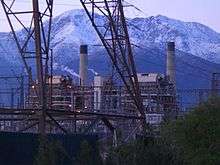
Electric power in Rancho Cucamonga is provided by Southern California Edison and the Rancho Cucamonga Municipal Utility, and the city is also home to the Reliant Energy Etiwanda Generating Station, on Etiwanda Avenue. This facility, one of five Reliant stations in California, is a natural gas-fired power plant, which began operation in 1963. At 640 MW net capacity, it is Reliant's second-highest capacity plant on the West Coast. It utilizes four steam turbine generators; of which units three and four are currently active. Steam turbines one and two, as well as a combustion turbine, were retired in 2003 and 2004, respectively. Several systems are in place to control gas emissions, and annually, over 900,000,000 gallons of recycled water are used for cooling.[48][49]
On 29 November 2011, The Inland Empire Utilities Agency has installed the first wind turbine in Rancho Cucamonga.[50]
In popular culture
The name "Cucamonga" became well known to fans of Jack Benny's popular radio program, in which an announcer, voiced by Mel Blanc, would call out: "Train leaving on track five for Anaheim, Azusa and Cu-camonga!" This running gag became so well known that it eventually led to a statue of Benny in Cucamonga.[51]
In the 1970s, Sesame Street often referenced Cucamonga, including the neologism "Cucamongaphobia".[52]
Bugs Bunny cartoons feature numerous references to Cucamonga. In Mutiny On the Bunny, Cucamonga is one of the stickers on the boat at the end of the cartoon that Bugs is riding in. In My Bunny Lies Over The Sea, Bugs reads map directions that include "turn left at Cucamonga".
Rancho Cucamonga has been featured on the Comedy Central hit show Workaholics where it was nicknamed "Hollywood East". The main characters are said to live in the heart of Rancho Cucamonga.
Rancho Cucamonga was featured in the 2000 stoner comedy film Next Friday starring Ice Cube and Mike Epps.
See also
References
- ↑ "California Cities by Incorporation Date" (Word). California Association of Local Agency Formation Commissions. Retrieved August 25, 2014.
- ↑ "Mayor & City Council". Rancho Cucamonga. Retrieved January 19, 2015.
- ↑ "City Clerk's Office". Rancho Cucamonga. Retrieved January 19, 2015.
- ↑ "City Treasurer James Frost". Rancho Cucamonga. Retrieved January 19, 2015.
- ↑ "City Manager's Office". Rancho Cucamonga. Retrieved January 19, 2015.
- ↑ "2010 Census U.S. Gazetteer Files – Places – California". United States Census Bureau.
- ↑ "Rancho Cucamonga". Geographic Names Information System. United States Geological Survey. Retrieved 2014-12-19.
- ↑ "Rancho Cucamonga (city) QuickFacts". United States Census Bureau. Retrieved 2015-03-20.
- 1 2 3 "American FactFinder - Results". United States Census Bureau. Retrieved 2015-05-22.
- ↑ "USPS - ZIP Code Lookup - Find a ZIP+ 4 Code By City Results". Retrieved 2007-02-20.
- ↑ "Number Administration System - NPA and City/Town Search Results". Retrieved 2007-02-20.
- 1 2 "Rancho Cucamonga | California, United States". Encyclopedia Britannica. Retrieved 2016-02-01.
- 1 2 "2010 Census Interactive Population Search: CA - Rancho Cucamonga city". U.S. Census Bureau. Retrieved 2014-07-12.
- 1 2 "Rancho_Cucamonga, California Climate". www.bestplaces.net. Retrieved 2016-01-14.
- 1 2 "California Department of Fish & Wildlife, Atlas of Biodiversity". www.dfg.ca.gov. Retrieved 2016-01-16.
- ↑ "'Tangled Vines' explores wine, the pride of Cucamonga". www.dailybulletin.com. Retrieved 2016-02-01.
- 1 2 "MONEY Magazine: Best places to live 2006: Rancho Cucamonga, CA snapshot". CNN. Archived from the original on 2011-12-01. Retrieved 2011-12-11.
- 1 2 Cooperstein, Paige. "The 27 Richest Neighborhoods In Southern California". Retrieved 2015-05-28.
- ↑ "Best High Schools Rankings | Top High Schools | US News". www.usnews.com. Retrieved 2016-01-14.
- ↑ "Rancho Cucamonga - Top 25 Companies by Number of Employees". www.cityofrc.us. Retrieved 2016-01-16.
- 1 2 3 4 "Rancho Cucamonga | California, United States". Encyclopedia Britannica. Retrieved 2016-01-15.
- 1 2 3 4 "Rancho Cucamonga - History of RC". www.cityofrc.us. Retrieved 2016-01-15.
- ↑ "RANCHO CUCAMONGA: An old tale of smuggler's gold". Press Enterprise. Retrieved 2016-01-16.
- ↑ "Thomas Vineyards – California's Oldest Winery". Ginoffvine. Retrieved 2016-01-16.
- ↑ "San Bernardino". ohp.parks.ca.gov. Retrieved 2016-01-16.
- ↑ "National Register of Historic Places Database and Research Page -- National Register of Historic Places Official Website--Part of the National Park Service". www.nps.gov. Retrieved 2016-01-16.
- ↑ "Parish History - Our Lady of Mount Carmel". Olmtcarmelranchocucamonga.org. Retrieved 2016-01-16.
- ↑ "Chinatown House in Rancho Cucamonga". Los Angeles Times. ISSN 0458-3035. Retrieved 2016-01-16.
- ↑ Roger Vincent and Adrian G. Uribarri (November 25, 2006). "Getting the masses in the mood". Los Angeles Times. Retrieved 2011-10-29.
- ↑ "Rubble Remains of a Community That Was — Grapeland," The Daily Report, July 13, 1957, page 3 / FONTANA–Between Fontana and Etiwanda lie the dry, dusty remains of a community that died for lack of water. The name of the town was Grapeland. A few people still live in the original tpwnsite, but the brilliant future that was predicted for it in the 1880's never came to pass. Unpaved dirt roads, still graded by San Bernardino County, run spasmodically through the area. Grapevines still cover much of the parched land; but gone are the citrus groves, the fruit trees, the early pioneer settlers. . . . The first settlers came to Grapeland in 1869. Later, more and more arrived, until in 1890 the need for adequate water became imperative. An irrigation district was formed and $200,000 in bonds were sold. With this money, the Sierra Vista Reservoir was built as the focal point of a network of irrigation pipes. It was to remain unused for 66 years, for the entire bond issue was declared illegal. Orchards and vineyards began to die. Residents moved out. The post office was closed in 1905. Homes, buildings were destroyed or abandoned. Today, the hot sun parches the empty fields of Grapeland—the community that died of thirst. / Still in fairly good shape along Grapeland's ghost roads are rabbit-proof stone walls around long-gone ciitrus orchards. / CONSTRUCTED 1886-1887, J.L. Scofield, Engineer and Builder is the legend proclaimed by this plaque in the Sierra Vista Reservoir, which proved a delusion to settlers. It remained dry until 1956, when the Fontana Union Water Co. plastered its colorful pebbly exterior and filled it with 5,000,000 gallons of water.
- ↑ "Cucamonga Peak - LA Trail Hikers". LA Trail Hikers. Retrieved 2016-02-04.
- ↑ "Rancho Cucamonga (city) QuickFacts from the US Census Bureau". Quickfacts.census.gov. Retrieved 2016-02-04.
- ↑ "Annual Estimates of the Resident Population for Incorporated Places: April 1, 2010 to July 1, 2015". Retrieved July 2, 2016.
- ↑ "Census of Population and Housing". Census.gov. Archived from the original on 2015-05-11. Retrieved 2015-06-04.
- ↑ "Profile of General Population and Housing Characteristics: 2010". American FactFinder. Retrieved 1 May 2016.
- ↑ "Census Bureau Releases 2010". U.S. Census Bureau. Retrieved 10 September 2016.
- ↑ "Rancho Cucamonga (city) QuickFacts". United States Census Bureau. Retrieved 2016-11-17.
- ↑ "Region Occupies Pivotal Position on Commercial Lanes". Citivu.com. Retrieved 2011-12-11.
- ↑
- ↑ "Company Information". Tamco Steel. Retrieved 2011-12-11.
- ↑ Rancho Cucamonga Finance Department. "Comprehensive Annual Financial Report: Year Ended June 30, 2011" (PDF). City of Rancho Cucamonga.
- ↑ "City of Rancho Cucamonga - Comprehensive Annual Financial Report". City of Rancho Cucamonga. 2009. Retrieved 2011-12-11.
- ↑ "Statewide Database". UC Regents. Retrieved 2014-11-30.
- ↑ "California's 31st Congressional District - Representatives & District Map". Civic Impulse, LLC.
- ↑ Modie, Neil (2005-08-12). "Where have Seattle's lefties gone?". Seattle Post-Intelligencer. Retrieved 2009-09-24.
- ↑ "Rancho Cucamonga - Police Department". Cityofrc.us. 2016-08-09. Retrieved 2016-11-17.
- ↑ "INSTITUTE OF MUSEUM AND LIBRARY SERVICES ANNOUNCES RECIPIENTS OF 2013 NATIONAL MEDAL FOR MUSEUM AND LIBRARY SERVICE". Imls.gov. Retrieved 2016-11-17.
- ↑
- ↑
- ↑ Wendy Leung, Inland Valley Daily Bulletin. "Wind turbine to bring inexpensive power to utilities agency - San Bernardino County Sun". Sbsun.com. Retrieved 2012-03-31.
- ↑ Paula Emick. "Rancho Cucamonga". Arcadia Publishing.
- ↑ "Sesame Street - Doctor Monster". YouTube. 2009-04-05. Retrieved 2016-11-17.
External links
| Wikivoyage has a travel guide for Rancho Cucamonga. |
| Wikimedia Commons has media related to Rancho Cucamonga, California. |
- Official website
- Rancho Cucamonga Redevelopment Agency
- History of Rancho Cucamonga on official city web site
- Rancho Cucamonga Library web site
- The History of Casa de Rancho Cucamonga
- Rancho Cucamonga Chamber of Commerce
- Cucamonga Valley Water District
 |
San Antonio Heights (CDP) | San Gabriel Mountains | San Gabriel Mountains & San Bernardino | |
| Upland | |
Fontana | ||
| ||||
| | ||||
| Ontario | Ontario & Ontario Airport | Fontana |
| |
^* Mayor selected from city council
|