Santa Clarita Valley
| Santa Clarita Valley | |
|---|---|
 | |
 Santa Clarita in Los Angeles County | |
| Country |
|
| State |
|
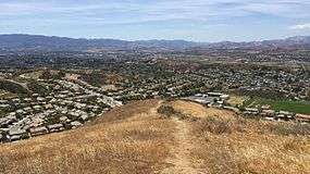
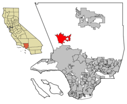
The Santa Clarita Valley is part of the upper watershed of Santa Clara River in Southern California. The valley was part of the 48,612-acre (19,673 ha) Rancho San Francisco Mexican land grant. Located in Los Angeles County, its main population center is the city of Santa Clarita which includes the communities of Canyon Country, Newhall, Saugus, and Valencia. Adjacent unincorporated communities include Castaic, Stevenson Ranch, Sunset Pointe, Tesoro, Val Verde, Westridge, and the new master planned community of Newhall Ranch.
The California Institute of the Arts, also known as CalArts, is located in Santa Clarita Valley in Valencia. College of the Canyons is a public two-year community college that operates within the Santa Clarita Community College District. The college is located on 153.4 acres (62.1 ha) of rolling, tree-dotted hills in the incorporated city of Santa Clarita in northern Los Angeles County, California. Dr. Dianne G. Van Hook is president of the college and chancellor of the Santa Clarita Community College District. She has headed the college and district since 1988.
Geography
The Santa Clarita Valley is bordered by the Lake Piru area, including the community of Val Verde, Los Padres National Forest, and Castaic Lake to the northwest, Sierra Pelona Mountains and Angeles National Forest to the north and northeast, San Gabriel Mountains to the east and southeast, and Santa Susana Mountains to the south and southwest, and Ventura County and the Santa Clara River Valley to the west. To the west-northwest lies the Topatopa Mountains.
Santa Clarita Valley is connected to a wide array of other nearby valleys: the San Fernando Valley and Los Angeles Basin via Newhall Pass to the south; Antelope Valley via CA 14 through Soledad Canyon to the northeast; and the San Joaquin Valley via I-5 through Tejon Pass to the northwest.
Downstream lies the Santa Clara River Valley, which was given the moniker Heritage Valley by the tourism bureau representing Piru, Fillmore, and Santa Paula. Upstream is Soledad Canyon which contains the communities of Vincent, Acton, Ravenna, and Agua Dulce.

Name
The Santa Clara River was named by Spanish explorers for Claire of Assisi. The valley later became known as "little Santa Clara" in deference to the Northern California mission and city of Santa Clara, California. In time, "little Santa Clara" became "Santa Clarita."[1]
Entertainment
Without traffic, Santa Clarita Valley is about a 20-minute drive from the Burbank Bob Hope Airport, and about a 50-minute drive from the Los Angeles International Airport. It is home to the 262-acre theme park Six Flags Magic Mountain and the gated waterpark Six Flags Hurricane Harbor. It offers a variety of family-oriented activity centers such as the Mountasia Family Fun Center and the Ice Station Valencia, restaurants and shopping centers, golf courses, cinemas and theaters, luxurious day spas, outdoor recreation areas like Castaic Lake and Placerita Canyon, acres of parkland, animal sanctuaries like the Gentle Barn and Gibbon Conservation Center, over 70 miles of paseos and trails for hiking and biking, and more. Santa Clarita is also home to a number of historical sites, such as the oil drilling town Mentryville and the William S. Hart Ranch & Museum. Santa Clarita Valley has a rich Western heritage, and since 1994, it has hosted an annual Cowboy Festival, which attracts more than 10,000 visitors each year.[2]
See also
- Santa Clarita, California
- Placerita Canyon State Park
- Newhall Pass (Beale's Cut)
- Rancho San Francisco
- Disney—Golden Oak Ranch
- Monogram Movie Ranch—Melody Ranch
- Santa Susana Mountains
- Santa Clara River
References
- ↑ http://www.scvhistory.com/scvhistory/scv-name.htm
- ↑ "About – Cowboy Festival". cowboyfestival.org. Retrieved 2016-02-14.
External links
| Wikivoyage has a travel guide for Santa Clarita Valley. |

Coordinates: 34°23′53″N 118°31′19″W / 34.398°N 118.522°W