Ventura County, California
| Ventura County, California | |||||||
|---|---|---|---|---|---|---|---|
| County | |||||||
| County of Ventura | |||||||
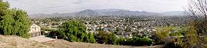
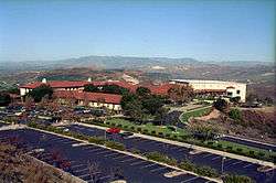
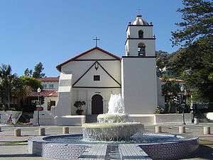
Images, from top down, left to right: Ventura City Hall in Old Town Ventura, Ojai Arcade in Ojai, a view of Camarillo, Ronald Reagan Presidential Library in Simi Valley, Point Mugu | |||||||
| |||||||
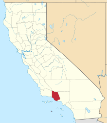 Location in the state of California | |||||||
 California's location in the United States | |||||||
| Country | United States | ||||||
| State | California | ||||||
| Region | California Central Coast | ||||||
| Established | March 22, 1872[1] | ||||||
| County seat | Ventura | ||||||
| Largest city |
Oxnard (population) Thousand Oaks (area) | ||||||
| Area | |||||||
| • Total | 2,208 sq mi (5,720 km2) | ||||||
| • Land | 1,843 sq mi (4,770 km2) | ||||||
| • Water | 365 sq mi (950 km2) | ||||||
| Highest elevation[2] | 8,835 ft (2,693 m) | ||||||
| Population (April 1, 2010)[3] | |||||||
| • Total | 823,318 | ||||||
| • Estimate (2015)[3] | 850,536 | ||||||
| • Density | 370/sq mi (140/km2) | ||||||
| Time zone | Pacific Time Zone (UTC−8) | ||||||
| • Summer (DST) | Pacific Daylight Time (UTC−7) | ||||||
| Area codes | 805, 747/818 | ||||||
| FIPS code | 06-111 | ||||||
| GNIS feature ID | 277320 | ||||||
| Website |
www | ||||||

.jpg)


Ventura County is a county in the southern part of the U.S. state of California. As of the 2010 census, the population was 823,318.[3] The county seat is Ventura.[4]
Ventura County comprises the Oxnard-Thousand Oaks-Ventura, CA Metropolitan Statistical Area, which is also included in the Los Angeles-Long Beach, CA Combined Statistical Area. It is also considered the southernmost county along the California Central Coast.[5]
History
Pre-colonial period
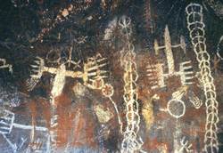
Ventura County was historically inhabited by the Chumash people, who also settled much of Santa Barbara and San Luis Obispo Counties, with their presence dating back 10,000-12,000 years.[6][7] The Chumash were hunter-gatherers, fishermen and also traders with the Mojave, Yokuts, and Tongva Indians.[8] The Chumash are also known for their rock paintings and for their great basketry. Chumash Indian Museum in Thousand Oaks has several reconstructed Chumash houses (‘apa) and there are several Chumash pictographs in the county, including the Burro Flats Painted Cave in Simi Valley. The plank canoe, called a tomol in Chumash, was important to their way of life. Canoe launching points on the mainland for trade with the Chumash of the Channel Islands were located at the mouth of the Ventura River, Mugu Lagoon and Point Hueneme.[9][10] This has led to speculations among archeologists of whether the Chumash could have had a pre-historic contact with Polynesians.[11][12] According to diachronic linguistics, certain words such as tomolo’o (canoe) could be related to Polynesian languages. The dialect of the Chumash language that was spoken in Ventura County was Ventureño.[13]
Several place names in the county has originated from Chumash, including Ojai, which means moon,[14] and Simi Valley, which originates from the word Shimiyi and refers to the stringy, thread-like clouds that typify the region.[15] Others include Point Mugu from the word Muwu (meaning “beach”), Saticoy from the word Sa’aqtiko’y (meaning “sheltered for the wind”), and Sespe Creek from the word S’eqp’e (meaning “kneecap”).[16]
Spanish period
In October 1542, the expedition led by Juan Rodríguez Cabrillo anchored in an inlet near Point Mugu; its members were the first Europeans to arrive in the area that would become Ventura County.[17]
Active occupation of California by Spain began in 1769. Gaspar de Portolà led a military expedition by land from San Diego to Monterey, passing through Ventura County in August of that year. A priest with the expedition, Father Juan Crespí, kept a journal of the trip and noted that the area was ideal for a mission to be established and it was a "good site to which nothing is lacking".[18] Also on this expedition was Father Junípero Serra, who later founded a mission on this site.
On March 31, 1782, the Mission San Buenaventura was founded by Father Serra.[19] It is named after Saint Bonaventure, one of the early intellectual founders of the Franciscan Order. The town that grew up around the mission, was originally and remains named San Buenaventura, although has been known as Ventura since 1891.[20]
In the 1790s, the Spanish Governor of California began granting land concessions to Spanish Californians who were often retiring soldiers. These concessions were known as ranchos and consisted of thousands of acres of land that were used primarily as ranch land for livestock. In Ventura County, Rancho Simi was granted in 1795 and Rancho El Conejo in 1802.
Mexican period
In 1822, California was notified of Mexico's independence from Spain and the Governor of California, the Junta, the military in Monterey and the priests and neophytes at Mission San Buenaventura swore allegiance to Mexico on April 11, 1822. California land that had been vested in the King of Spain was now owned by the nation of Mexico.
By the 1830s, Mission San Buenaventura was in a decline with fewer neophytes joining the mission. The number of cattle owned by the mission dropped from first to fifteenth ranking in the California Missions.[21] The missions were secularized by the Mexican government in 1834. The Mexican governors began granting land rights to Mexican Californians, often retiring soldiers. By 1846, there were 19 rancho grants in Ventura County.[22] In 1836, Mission San Buenaventura was transferred from the Church to a secular administrator. The natives who had been working at the mission gradually left to work on the ranchos. By 1839, only 300 Indians were left at the Mission and it slipped into neglect.[23]
Several outhouses were discovered in July 2007 dating back to the 1800s where a new site had been cleared to prepare for development. The area proved to be a treasure trove for archaeologists who braved the lingering smell in the dirt to uncover artifacts that showed heavy utilization by mission inhabitants, Indians, early settlers and Spanish and Mexican soldiers.[24]
American period
The Mexican–American War began in 1846 but its effect was not felt in Ventura County until 1847. In January of that year, Captain John C. Frémont led the California Battalion into San Buenaventura finding that the Europeans had fled leaving only the Indians in the Mission. Fremont and the Battalion continued south to sign the Treaty of Cahuenga with General Andrés Pico. The Treaty of Guadalupe Hidalgo formally transferred California to the United States in 1848.[25]
By 1849, a constitution had been adopted for the California territory. The new Legislature met and divided the pending state into 27 counties. At the time, the area that would become Ventura County was the southern part of Santa Barbara County.[26]
The 1860s brought many changes to the area. A drought caused many of the ranchos to experience financial difficulties and most were divided, sub-divided and sold. Large sections of land were bought by eastern capitalists based on favorable reports of petroleum deposits. A United States Post Office was opened at Mission San Buenaventura in 1861. On April 1, 1866, the town of San Buenaventura was incorporated becoming the first officially recognized town in what would become Ventura County.[27]
On January 1, 1873, Ventura County was officially split from Santa Barbara County, bringing a flurry of change. That same year, a courthouse and wharf were built in San Buenaventura. A bank was opened and the first public library was created. The school system grew, with the first high school opening in 1890.[28]
Other towns were starting in the county. A plan for Hueneme (later Port Hueneme) was recorded in 1874, and Santa Paula's plan was recorded in 1875. The community of Nordhoff (later renamed Ojai) was started in 1874.[29] Bardsdale, Fillmore, Piru and Montalvo were established in 1887.[30] 1892 saw Simi (later Simi Valley), Somis, Saticoy and Moorpark. Oxnard was a late-comer, not being established until 1898.[31]
The Southern Pacific Railroad laid tracks through San Buenaventura in 1887. For convenience in printing their timetables, Southern Pacific shortened San Buenaventura to Ventura. The Post Office soon followed suit. While the city remains officially known as San Buenaventura, it is more commonly referred to as Ventura.[32] The rail line to northern California originally went through Saugus, Fillmore and Santa Paula, providing a boom to those communities along the line. In 1905, Tunnel #26 was completed between Chatsworth and Corriganville near Simi Valley, shortening the rail route. At 7,369 feet (2,246 m), Tunnel #26 was the longest tunnel ever constructed in its day.[33] This tunnel joined the railroad spur coming the other direction from Montalvo through Camarillo, Moorpark and Simi Valley, making the contemporary main line used today. One stop along the way, at a 90 degree turn, was at a sugar beet processing factory. The factory bore the name of its absentee owners, the Oxnard Brothers. A small community of farm and factory workers grew near the train stop. That community, now bearing the name of the factory shortened to the one word train stop, has become the largest city in Ventura County, Oxnard.[34][35]
Oil has been known in Ventura County since before the arrival of the Europeans, as the native Chumash people used tar from natural seeps as a sealant and waterproofing for baskets and canoes. In the 1860s, several attempts were made to harvest the petroleum products under Ventura County but none were financially successful, and the oil speculators eventually changed from oil to land development. In 1913, oil exploration began in earnest, with Ralph Lloyd obtaining the financial support of veteran oil man Joseph B. Dabney. Their first well, named "Lloyd No. 1", was started on January 20, 1914. The well struck oil at 2558 feet (780 m) but was destroyed when it went wild. Other wells met a similar fate, until 1916, when a deal was struck with the Shell Oil Company. 1916 was the year the large South Mountain Oil Field was discovered, and other deals followed with General Petroleum in 1917 and Associated Oil Company in 1920. At its peak, the largest oil field in the county, the Ventura Avenue oilfield, discovered in 1919 in the hills north of Ventura, was producing 90,000 barrels (14,000 m3) of oil a day, with annual production of over a million and a half barrels. More oil fields came on-line in the 1920s and 1930s, with the Rincon field, the second-largest, in 1927, and the adjacent San Miguelito in 1931.[36][37]
In the early hours of the morning of March 12–13, 1928, the St. Francis Dam collapsed, sending nearly 12,500 million US gallons (47 gigalitres) of water rushing through the Santa Clarita Valley killing as many as 600 people,[38] destroying 1,240 homes and flooding 7,900 acres (32 km2) of land, devastating farm fields and orchards.[39] This was the largest single disaster to strike Ventura County and the second largest, in terms of lives lost, in the state.
Modern period

Ventura County can be separated into two major parts, East County and West County. East County consists of all cities east of the Conejo Grade. Geographically East County is the end of the Santa Monica Mountains, in which the Conejo Valley is located, and where there is a considerable increase in elevation. Communities which are considered to be in the East County are Thousand Oaks, Newbury Park, Lake Sherwood, Hidden Valley, Santa Rosa Valley, Oak Park, Moorpark, and Simi Valley. A majority of these communities are in the Conejo Valley.
West County, which is everything west of the Conejo Grade, consists of communities such as Camarillo, Oxnard, Somis, Point Mugu, Port Hueneme, Ventura, Ojai, Santa Paula, and Fillmore. West County consists of some of the first developed cities in the county. The largest beach communities are located in West County on the coastline of the Channel Islands Harbor.
Starting in the mid-1900s, there was a large growth in population in the East County, moving from the San Fernando Valley in Los Angeles and out into the Conejo and Simi Valleys. Part of the Conejo Valley belongs to Los Angeles County. This part consists of Calabasas, Hidden Hills, Agoura Hills, Agoura, and Westlake Village. The other half of the Conejo Valley, which belongs to Ventura County, consists of Lake Sherwood, Hidden Valley, Oak Park, Thousand Oaks, and Newbury Park, which was formerly an unincorporated area that is now the most westerly part of Thousand Oaks. Many working-class people migrated to this area during the 1960s and 1970s out of East and Central Los Angeles. As a result, there was a large growth in population into the Conejo Valley and into Ventura County through the U.S. Route 101 corridor. Making the U.S. 101 a full freeway in the 1960s, and the expansions that followed, helped make commuting to Los Angeles easier and opened the way for development westward. The communities that have seen the most substantial development are Calabasas, Hidden Hills, Agoura Hills, Westlake Village, Thousand Oaks, and Newbury Park.
Development moved farther down the US 101 corridor and sent population rising in West County cities as well. The largest population growth there has been in Camarillo, Oxnard, and Ventura. Development in the East County and along the US 101 corridor is rare today, because most of these cities are master-planned cities, such as Thousand Oaks and Simi Valley, and are approaching build-out. Although the area still has plenty of open space and land, almost all of it is mandated to never be developed as part of the master plan of each city.[40] Because of this, its private low-key location, its country feel, and its proximity to Los Angeles, the Conejo Valley area has become a very attractive place to live. Like most areas of Ventura County, it once had relatively inexpensive real estate, but prices have risen sharply. For example, real estate in Newbury Park has increased in price by over 250% in the last 10 years. Median home prices in the Conejo Valley now range from $700,000 to $2.2 million. Camarillo also experienced rapid growth in the 1960s and 1970s following a favorable article published in National Geographic Magazine citing the excellent climate. National Geographic magazine compared the Mediterranean climate to the French Riviera. After this, many developers and residents came to Camarillo for the favorable weather.
Geography

According to the U.S. Census Bureau, the county has a total area of 2,208 square miles (5,720 km2), of which 1,843 square miles (4,770 km2) is land and 365 square miles (950 km2) (16.5%) is water.[42][43]
Parts of the county are on the Oxnard Plain which includes the cities of Oxnard, Camarillo, Port Hueneme and much of Ventura. Other cities and communities lie in the intermountain valleys of the Transverse Range. The Santa Clara River Valley is the most prominent valley, while other valleys include Conejo Valley, Simi Valley, Santa Rosa Valley, Tierra Rejada Valley and Las Posas Valley. Other parts of the county are on small coastal mountains, such as the Santa Ynez Mountains, Simi Hills, Santa Monica Mountains and the Piru Mountains. Most of the population of Ventura County lives in the southern portion of the county. The major population centers are the Oxnard Plain and the Simi and Conejo Valleys. In local media, the county is usually split between the eastern portion, generally associated with the San Fernando Valley, and the western portion, often referred to as “Oxnard-Ventura."
Because the total amount of precipitation is small, conserving water and obtaining water from additional sources outside of Ventura County are vital concerns.[44] The climate, though mostly mild and dry, varies because of the variations in topography through for instance differences in elevation and physical geography. The Santa Clara River is the principal waterway. Lake Casitas, an artificial reservoir, is the largest body of water.
The highest peaks in the county include Mount Pinos (8831', 2697 m), Frazier Mountain (8017', 2444 m), and Reyes Peak (7525', 2294 m) in the Transverse Ranges. The uplands are well-timbered with coniferous forests, and receive plentiful snow in the winter. Mount Pinos is sacred to the Chumash Indians. It is known to them as Iwihinmu, and was considered to be the center of the universe; being the highest peak in the vicinity, it has a spectacular view, unimpeded in three directions.[45]
The USDA Economic Research Service rated Ventura County the most desirable county to live in the 48 contiguous states, using six metrics of climate ("mild, sunny winters, temperate summers, low humidity"), topographic variation, and access to water, "that reflect environmental qualities most people prefer."[46]
Physical geography


There are 555,953 acres (224,986 ha) outside of national forest land in Ventura County, which means that 53 percent of the county’s total area is made up of national forest. Of the land outside of national forest land, approximately 59 percent is agricultural and 17.5 percent urban.[41] North of Highway 126, the county is mountainous and mostly uninhabited, and contains some of the most unspoiled, rugged and inaccessible wilderness remaining in southern California. Most of this land is in the Los Padres National Forest, and includes the Chumash Wilderness in the northernmost portion, adjacent to Kern County, as well as the large Sespe Wilderness and portions of both the Dick Smith Wilderness and Matilija Wilderness (both of these protected areas straddle the line with Santa Barbara County). All of the wilderness areas are within the jurisdiction of Los Padres National Forest.
The coastal plain was formed by the deposition of sediments from the Santa Clara River and from the streams of the Calleguas-Conejo drainage system. It has a mean elevation of fifty feet (15 m), but at points south of the Santa Clara River, the elevation is as much as 150 feet (46 m), and at points north of the river, as much as 300 feet (91 m). The coastal plain is generally known as the Oxnard Plain with the part that centers on Camarillo lying east of the Revelon Slough is called Pleasant Valley. Most of the arable land in the county is found on the coastal plain. Small coastal mountains rim Ventura County on its landward side. They range in elevation from 50 feet (15 m) along the coast south of the coastal plain, to about 3,100 feet (940 m) in the Santa Monica Mountains. The Santa Ynez Mountains, the Topatopa Mountains, and the Piru Mountains make up the northern boundary of the county the Santa Susana Mountains the eastern boundary, and the Simi Hills and the Santa Monica Mountains make up the southern border towards Los Angeles County. South Mountain and Oak Ridge are low and long mountains that separate Santa Clara Valley from the Las Posas Valley and Simi Valley. The Camarillo Hills and the Las Posas Hills extend from Camarillo to Simi Valley and separate the Las Posas-Simi area from the Santa Rosa Valley and Tierra Rejada Valley.[47]


The intermountain valley of the Santa Clara River is the most prominent valley in the county and trends east-southwest. The Santa Clara River drains an area of 1,605 square miles and flows from its headwaters in Los Angeles to where it empties into the Pacific. Its principal tributaries are Piru Creek, Santa Paula Creek, and Sespe Creek. The valley of the Ventura River is a narrow valley north of Ventura. Ojai Valley is connected to the Ventura River Valley by San Antonio Creek. The small Upper Ojai Valley, east of Ojai Valley and 300-to-500-foot higher (91 to 152 m), drains to the Ventura River on the west and to Santa Paula Creek on the east. Ojai and Upper Ojai Valleys are surrounded by mountains and are rich agricultural areas. The Ventura River flows south and drains an area of 226 square miles. Over South Mountain and Oak Ridge, south of the Santa Clara River, are Las Posas Valley and Simi Valley. Las Posas Valley extends eastward from the Oxnard Plain almost to Simi Valley, which is in the east end of Ventura County. The town of Simi Valley is bounded on the east by the Santa Susana Mountains and on the south by the Simi Hills. To the south, over the Camarillo- and Las Posas Hills, are Santa Rosa- and Tierra Rejada Valleys, which extend from Camarillo eastward for ten miles. In the hills south of Santa Rosa Valley is the broad Conejo Valley. Santa Rosa Valley, Conejo Valley, Simi Valley, and Tierra Rejada Valley are drained by Calleguas Creek and its principal tributary, Conejo Creek. These creeks originate in the Santa Susana and Santa Monica Mountains.[44]
The County's diverse coastline features a variety of terrain. There are many State beaches: Emma Wood, San Buenaventura, McGrath, and Mandalay State Beach. Other beaches include Channel Islands Beach, Solimar Beach, Oxnard Beach Park, and Silver Strand Beach. While Point Mugu State Park is known for its steep coastal terrain with little beach access, nearby County Line Beach in the south coast community of Solromar is part of the fabled Malibu coastline. Ventura County has plenty of other surf spots along the coast including the notable surf spot, Rincon Point, on the Santa Barbara County-line.
Climate
Ventura County has a considerable range in climate because of differences in topography between one part of the county and another. Rainfall is limited in summer and crops have to be irrigated. The average annual temperature is near 60 °F at low elevations near the ocean, in the 50’s over most of the northern two-thirds of the county, and less than 45 °F in the Topatopa Mountains. The annual range in temperature is between 70 °F and 80 °F on the Coastal Plain and as much as 100 °F in the interior. For July, the average maximum temperature is between 70 °F and 80 °F on the Coastal Plain but exceeds 90 °F in the upper part of the Ventura- and Cuyama River Valleys. For January, the average minimum temperature is near 40 °F on the coast but in the lower 30’s and upper 20’s in the northern parts of Ventura County. No temperature data are available for the highest point in the county, Mount Pinos. The length of the growing season ranges more than 300 days near the coast to less than 175 days in the coldest part in northern Ventura County. In both the northern and southern ends of the county, the annual precipitation totals between ten and fifteen inches. In the Topatopa Mountains, the annual total is more than thirty-three inches. The drier parts of the county get less than five inches of rain annually, and the higher and wetter parts get more than 60 inches annually. Measureable amounts of rainfall in Ventura County are reported on thirty to thirty-five days annually, and half an inch or more on six to twelve days annually. In the northern parts of Ventura County, snowfall averages five inches or more per year, and along the northern border and Mount Pinos, more than twenty inches.[47]
Ecology and Wildlife
The ecology of Ventura county varies from place to place. Mostly, though, the native wildlife has been partially taken over by foreign wildlife. The wildlife continues to diminish today, but at a slower rate, due to the protection efforts of wildlife protection agencies.
Oak is common in Ventura County. Invasive grasses have taken over the native grasses, but much native wildlife, like poison oak, still exists in the county.
Raccoons and skunks are common in the neighborhoods. In the wild, mountain lions and bobcats roam around, along with foxes and coyotes. The apex predator is the American black bear.[48]
The Channel Islands in Ventura County are Anacapa and San Nicholas Islands. Both are home to the deer mouse, the latter home to the island fox. Island oak exist on both.
Adjacent counties
- Santa Barbara County, California — west
- Kern County, California — north
- Los Angeles County, California — east
National protected areas
Rivers
Rivers in Ventura County include:
- Los Sauces Creek
- Madrianio Creek
- Padre Juan Canyon
- Ventura River
- Manuel Canyon
- Cañada Larga
- Cañada de Alisos
- Coyote Creek
- Lake Casitas
- Laguna Creek
- Willow Creek
- Santa Ana Creek
- Roble-Casitas Canal
- Poplin Creek
- Deep Cat Lake
- East Fork Coyote Creek
- West Fork Coyote Creek
- Lake Casitas
- Matilija Creek
- Rattlesnake Creek
- Lime Creek
- Murietta Creek
- Middle Fork Matilija Creek
- Upper North Fork Matilija Creek
- North Fork Matilija Creek (This and Matilija Creek form the Ventura River's headwaters.)
- Santa Clara River
- Calleguas Creek
Transportation
Major highways

Unconstructed
Public transportation
Ventura County is served by Amtrak and Metrolink trains along the main coast rail line, as well as Greyhound Lines, Gold Coast Transit (formerly South Coast Area Transit), and VISTA buses. The cities of Camarillo, Moorpark, Simi Valley and Thousand Oaks have their own small bus systems.
Park authorized commercial service operators provide access to the five islands of Channel Islands National Park.[49]
Airports
- Oxnard Airport, just west of Downtown Oxnard and was Ventura County's only commercial airport, it now no longer takes public flights. It is also the county's largest airport.
- Camarillo Airport, formerly a US Air Force Base, is a general aviation airport located south of the City of Camarillo. It is the current base of operations of the Ventura County Sheriff's Department Aviation Unit and the home of the VCSD's Training Facility and Academy, the Ventura County Criminal Justice Training Center. The Camarillo Airport also serves as the base of operations for the Ventura County Fire Department and facilitates the Oxnard College Regional Fire Academy and the Ventura County Reserve Officers Training Center.
- Santa Paula Airport is a privately owned airport; however, it is open to the public for general aviation.
Government
Current county supervisors are Steve Bennett, Linda Parks, Kathy Long, Peter Foy, and John C. Zaragoza. Geoff Dean is the sheriff of the Ventura County Sheriff's Department. Mark Lorenzen is the chief of the Ventura County Fire Department.
Federal and state representation
Much of the county, including the cities of Thousand Oaks, Oxnard and Moorpark, lie within the 26th congressional district, which is represented by Democrat Julia Brownley.[50] Other parts of the county are in California's 24th congressional district, represented by Democrat Lois Capps, California's 25th congressional district, represented by Republican Steve Knight, and California's 30th congressional district, represented by Democrat Brad Sherman.[51] For the previous twenty five years, most of Ventura County was represented by Elton Gallegly, a conservative Republican from Simi Valley, who retired in 2012.
In the California State Senate, Ventura County is split between the 19th Senate District, represented by Democrat Hannah-Beth Jackson, and the 27th Senate District, represented by Democrat Henry Stern.[52]
In the California State Assembly, Ventura County is split between four legislative districts:[53]
- the 37th Assembly District, represented by Democrat Monique Limón,
- the 38th Assembly District, represented by Republican Dante Acosta,
- the 44th Assembly District, represented by Democrat Jacqui Irwin, and
- the 45th Assembly District, represented by Democrat Matt Dababneh.
Politics
| Year | GOP | DEM | Others |
|---|---|---|---|
| 2016 | 37.2% 131,688 | 54.6% 193,185 | 8.1% 28,738 |
| 2012 | 45.2% 147,958 | 52.2% 170,929 | 2.7% 8,825 |
| 2008 | 42.8% 145,853 | 55.0% 187,601 | 2.2% 7,587 |
| 2004 | 51.2% 160,314 | 47.3% 148,859 | 1.3% 4,020 |
| 2000 | 48.2% 136,173 | 47.1% 133,258 | 4.7% 13,261 |
| 1996 | 43.5% 109,202 | 44.1% 110,772 | 12.4% 31,220 |
| 1992 | 35.5% 94,911 | 37.0% 99,011 | 27.5% 73,725 |
| 1988 | 61.6% 147,604 | 37.2% 89,065 | 1.2% 2,804 |
| 1984 | 68.7% 151,383 | 30.2% 66,550 | 1.2% 2,529 |
| 1980 | 60.3% 114,930 | 29.5% 56,311 | 10.2% 19,409 |
| 1976 | 53.2% 82,670 | 44.1% 68,529 | 2.7% 4,201 |
| 1972 | 63.2% 95,310 | 32.7% 49,307 | 4.1% 6,188 |
| 1968 | 51.4% 59,705 | 41.1% 47,794 | 7.5% 8,762 |
| 1964 | 41.0% 40,264 | 58.8% 57,805 | 0.2% 169 |
| 1960 | 49.6% 35,074 | 50.0% 35,334 | 0.5% 315 |
| 1956 | 49.9% 26,342 | 49.8% 26,276 | 0.3% 149 |
| 1952 | 52.5% 24,534 | 47.0% 21,967 | 0.6% 256 |
| 1948 | 42.2% 13,930 | 54.8% 18,100 | 3.1% 1,019 |
| 1944 | 40.2% 11,071 | 59.3% 16,342 | 0.5% 131 |
| 1940 | 42.2% 11,225 | 57.0% 15,182 | 0.9% 227 |
| 1936 | 35.8% 7,579 | 63.1% 13,384 | 1.1% 235 |
| 1932 | 37.3% 6,908 | 58.8% 10,903 | 3.9% 724 |
| 1928 | 70.2% 9,017 | 28.9% 3,717 | 0.9% 117 |
| 1924 | 65.2% 5,705 | 10.4% 911 | 24.4% 2,139 |
| 1920 | 76.0% 5,231 | 19.0% 1,305 | 5.0% 347 |
| Year | GOP | DEM |
|---|---|---|
| 2014 | 46.9% 93,797 | 53.1% 106,072 |
| 2010 | 49.3% 128,082 | 45.3% 117,800 |
| 2006 | 61.0% 134,862 | 34.3% 75,790 |
| 2003 | 51.5% 116,722 | 23.7% 53,705 |
| 2002 | 47.2% 91,193 | 43.2% 83,557 |
| 1998 | 43.8% 91,093 | 53.0% 110,226 |
| 1994 | 62.4% 136,417 | 33.4% 73,163 |
| 1990 | 57.6% 106,234 | 36.9% 68,139 |
| 1986 | 67.2% 118,640 | 31.1% 54,893 |
| 1982 | 55.2% 99,130 | 42.4% 76,094 |
| 1978 | 40.6% 57,777 | 52.8% 75,173 |
| 1974 | 50.5% 60,122 | 47.2% 56,189 |
| 1970 | 58.6% 63,790 | 38.9% 42,350 |
| 1966 | 60.9% 58,068 | 39.1% 37,224 |
| 1962 | 45.2% 31,899 | 53.5% 37,777 |
For many years, Ventura County voted consistently for Republican candidates for local, statewide and federal offices. Only recently has the county begun favoring Democratic candidates in both federal and state elections. While Republicans used to win a large majority of votes throughout the 1970s and 1980s, no party has received more than 55% of the county's vote since 1992. Prior to Barack Obama's victory in the county in 2008, the last Democrat to win a majority was Lyndon Johnson in 1964, though Democrat Bill Clinton carried the county by a plurality in 1992 and 1996.
On March 3, 2008, Democratic registration surpassed Republican registration and this Democratic edge has grown since.[55] The cities of Camarillo, Moorpark, Simi Valley, and Thousand Oaks all have voter rolls with Republican pluralities. The remaining cities and towns in the county have a Democratic plurality or majority on the voter rolls, while the unincorporated areas are split almost evenly between the parties.
Voter registration statistics
| Population and registered voters | ||
|---|---|---|
| Total population[56] | 815,745 | |
| Registered voters[57][note 1] | 431,154 | 52.9% |
| Democratic[57] | 166,462 | 38.6% |
| Republican[57] | 155,180 | 36.0% |
| Democratic–Republican spread[57] | +11,282 | +2.6% |
| Independent[57] | 11,072 | 2.6% |
| Green[57] | 2,324 | 0.5% |
| Libertarian[57] | 2,700 | 0.6% |
| Peace and Freedom[57] | 926 | 0.2% |
| Americans Elect[57] | 13 | 0.0% |
| Other[57] | 5,733 | 1.3% |
| No party preference[57] | 86,744 | 20.1% |
Cities by population and voter registration
| Cities by population and voter registration | |||||||
|---|---|---|---|---|---|---|---|
| City | Population[56] | Registered voters[57] [note 1] |
Democratic[57] | Republican[57] | D–R spread[57] | Other[57] | No party preference[57] |
| Camarillo | 64,340 | 63.2% | 33.1% | 43.2% | -10.1% | 7.8% | 18.6% |
| Fillmore | 14,863 | 42.7% | 47.0% | 27.8% | +19.2% | 7.7% | 20.0% |
| Moorpark | 34,100 | 58.6% | 33.8% | 40.8% | -7.0% | 7.8% | 20.2% |
| Ojai | 7,496 | 65.9% | 46.0% | 27.3% | +18.7% | 9.1% | 20.2% |
| Oxnard | 194,972 | 36.4% | 51.6% | 22.5% | +29.1% | 6.4% | 21.5% |
| Port Hueneme | 21,717 | 40.4% | 47.5% | 25.2% | +22.3% | 8.1% | 21.8% |
| San Buenaventura (Ventura) | 105,809 | 61.1% | 42.4% | 32.3% | +10.1% | 8.5% | 19.4% |
| Santa Paula | 29,248 | 39.8% | 53.4% | 23.7% | +29.7% | 6.6% | 18.5% |
| Simi Valley | 122,864 | 57.8% | 30.3% | 44.7% | -14.4% | 8.2% | 19.6% |
| Thousand Oaks | 125,633 | 62.4% | 31.9% | 41.8% | -9.9% | 8.0% | 21.0% |
Crime
The following table includes the number of incidents reported and the rate per 1,000 persons for each type of offense.
| Population and crime rates | ||
|---|---|---|
| Population[56] | 815,745 | |
| Violent crime[58] | 2,021 | 2.48 |
| Homicide[58] | 29 | 0.04 |
| Forcible rape[58] | 116 | 0.14 |
| Robbery[58] | 757 | 0.93 |
| Aggravated assault[58] | 1,119 | 1.37 |
| Property crime[58] | 7,696 | 9.43 |
| Burglary[58] | 2,954 | 3.62 |
| Larceny-theft[58][note 2] | 11,221 | 13.76 |
| Motor vehicle theft[58] | 1,154 | 1.41 |
| Arson[58] | 113 | 0.14 |
Cities by population and crime rates
| Cities by population and crime rates | ||||||||
|---|---|---|---|---|---|---|---|---|
| City | Population[59] | Violent crimes[59] | Violent crime rate per 1,000 persons |
Property crimes[59] | Property crime rate per 1,000 persons | |||
| Camarillo | 66,506 | 61 | 0.92 | 955 | 14.36 | |||
| Fillmore | 15,298 | 24 | 1.57 | 198 | 12.94 | |||
| Moorpark | 35,102 | 41 | 1.17 | 330 | 9.40 | |||
| Ojai | 7,607 | 13 | 1.71 | 162 | 21.30 | |||
| Oxnard | 201,797 | 603 | 2.99 | 4,071 | 20.17 | |||
| Port Hueneme | 22,142 | 65 | 2.94 | 467 | 21.09 | |||
| Santa Paula | 29,899 | 91 | 3.04 | 590 | 19.73 | |||
| Simi Valley | 126,686 | 141 | 1.11 | 1,916 | 15.12 | |||
| Thousand Oaks | 129,171 | 157 | 1.22 | 1,838 | 14.23 | |||
| Ventura | 108,511 | 310 | 2.86 | 3,885 | 35.80 | |||
Demographics
2011
| Population, race, and income | |||||
|---|---|---|---|---|---|
| Total population[56] | 815,745 | ||||
| White[56] | 578,324 | 70.9% | |||
| Black or African American[56] | 14,435 | 1.8% | |||
| American Indian or Alaska Native[56] | 9,186 | 1.1% | |||
| Asian[56] | 56,230 | 6.9% | |||
| Native Hawaiian or other Pacific Islander[56] | 1,410 | 0.2% | |||
| Some other race[56] | 123,892 | 15.2% | |||
| Two or more races[56] | 32,268 | 4.0% | |||
| Hispanic or Latino (of any race)[60] | 323,735 | 39.7% | |||
| Per capita income[61] | $32,740 | ||||
| Median household income[62] | $76,728 | ||||
| Median family income[63] | $86,321 | ||||
Places by population, race, and income
| Places by population and race | ||||||||
|---|---|---|---|---|---|---|---|---|
| Place | Type[64] | Population[56] | White[56] | Other[56] [note 3] |
Asian[56] | Black or African American[56] |
Native American[56] [note 4] |
Hispanic or Latino (of any race)[60] |
| Bell Canyon | CDP | 2,291 | 83.9% | 3.0% | 10.3% | 0.0% | 2.7% | 3.4% |
| Camarillo | City | 64,340 | 73.0% | 13.8% | 10.7% | 1.4% | 1.0% | 24.5% |
| Casa Conejo | CDP | 3,424 | 89.0% | 4.6% | 2.1% | 4.3% | 0.0% | 32.6% |
| Channel Islands Beach | CDP | 3,299 | 94.0% | 4.8% | 1.2% | 0.0% | 0.0% | 19.2% |
| El Rio | CDP | 6,014 | 60.2% | 35.9% | 1.6% | 1.5% | 0.9% | 79.5% |
| Fillmore | City | 14,863 | 60.4% | 35.0% | 3.2% | 0.6% | 0.9% | 74.8% |
| Lake Sherwood | CDP | 1,396 | 88.4% | 6.0% | 0.5% | 2.5% | 2.6% | 2.9% |
| Meiners Oaks | CDP | 3,339 | 79.5% | 15.4% | 0.8% | 1.1% | 3.2% | 29.3% |
| Mira Monte | CDP | 7,666 | 86.7% | 9.2% | 1.8% | 0.9% | 1.4% | 15.7% |
| Moorpark | City | 34,100 | 75.1% | 18.3% | 5.4% | 1.0% | 0.2% | 31.2% |
| Oak Park | CDP | 14,045 | 85.4% | 4.3% | 9.6% | 0.6% | 0.0% | 6.2% |
| Oak View | CDP | 4,166 | 81.0% | 17.3% | 0.0% | 0.0% | 1.7% | 27.8% |
| Ojai | City | 7,496 | 84.4% | 13.4% | 2.0% | 0.0% | 0.1% | 17.0% |
| Oxnard | City | 194,972 | 59.7% | 26.6% | 7.9% | 3.2% | 2.6% | 71.6% |
| Piru | CDP | 1,638 | 60.0% | 39.9% | 0.0% | 0.2% | 0.0% | 83.6% |
| Port Hueneme | City | 21,717 | 63.6% | 19.5% | 7.1% | 5.1% | 4.7% | 51.3% |
| San Buenaventura (Ventura) | City | 105,809 | 73.4% | 21.0% | 3.2% | 1.4% | 1.0% | 32.8% |
| Santa Paula | City | 29,248 | 53.0% | 45.5% | 0.6% | 0.2% | 0.7% | 78.8% |
| Santa Rosa Valley | CDP | 3,143 | 91.8% | 3.3% | 4.9% | 0.0% | 0.0% | 6.5% |
| Santa Susana | CDP | 1,115 | 92.4% | 4.8% | 0.0% | 2.8% | 0.0% | 8.1% |
| Saticoy | CDP | 851 | 59.3% | 36.3% | 0.0% | 0.0% | 4.3% | 74.7% |
| Simi Valley | City | 122,864 | 74.8% | 14.3% | 8.8% | 1.2% | 0.9% | 24.3% |
| Thousand Oaks | City | 125,633 | 79.6% | 9.1% | 9.8% | 1.1% | 0.4% | 16.0% |
| Places by population and income | |||||
|---|---|---|---|---|---|
| Place | Type[64] | Population[65] | Per capita income[61] | Median household income[62] | Median family income[63] |
| Bell Canyon | CDP | 2,291 | $85,789 | $220,764 | $230,455 |
| Camarillo | City | 64,340 | $37,840 | $84,168 | $101,334 |
| Casa Conejo | CDP | 3,424 | $26,950 | $84,286 | $86,630 |
| Channel Islands Beach | CDP | 3,299 | $53,891 | $70,313 | $69,333 |
| El Rio | CDP | 6,014 | $15,861 | $56,415 | $58,665 |
| Fillmore | City | 14,863 | $20,582 | $60,605 | $67,784 |
| Lake Sherwood | CDP | 1,396 | $104,724 | $210,391 | $211,484 |
| Meiners Oaks | CDP | 3,339 | $33,264 | $51,955 | $73,365 |
| Mira Monte | CDP | 7,666 | $32,718 | $71,723 | $83,968 |
| Moorpark | City | 34,100 | $36,375 | $103,009 | $107,412 |
| Oak Park | CDP | 14,045 | $55,681 | $128,618 | $143,188 |
| Oak View | CDP | 4,166 | $38,062 | $80,614 | $81,750 |
| Ojai | City | 7,496 | $36,769 | $63,750 | $89,338 |
| Oxnard | City | 194,972 | $20,612 | $60,191 | $61,965 |
| Piru | CDP | 1,638 | $15,730 | $49,141 | $47,734 |
| Port Hueneme | City | 21,717 | $23,391 | $52,244 | $56,566 |
| San Buenaventura (Ventura) | City | 105,809 | $31,775 | $66,226 | $81,616 |
| Santa Paula | City | 29,248 | $19,713 | $53,359 | $55,399 |
| Santa Rosa Valley | CDP | 3,143 | $71,594 | $154,931 | $176,938 |
| Santa Susana | CDP | 1,115 | $40,271 | $111,610 | $112,027 |
| Saticoy | CDP | 851 | $12,192 | $34,375 | $35,299 |
| Simi Valley | City | 122,864 | $35,467 | $89,452 | $97,999 |
| Thousand Oaks | City | 125,633 | $46,093 | $100,373 | $112,876 |
2010
| Historical population | |||
|---|---|---|---|
| Census | Pop. | %± | |
| 1880 | 5,073 | — | |
| 1890 | 10,071 | 98.5% | |
| 1900 | 14,367 | 42.7% | |
| 1910 | 18,347 | 27.7% | |
| 1920 | 28,724 | 56.6% | |
| 1930 | 54,976 | 91.4% | |
| 1940 | 69,685 | 26.8% | |
| 1950 | 114,647 | 64.5% | |
| 1960 | 199,138 | 73.7% | |
| 1970 | 376,430 | 89.0% | |
| 1980 | 529,174 | 40.6% | |
| 1990 | 669,016 | 26.4% | |
| 2000 | 753,197 | 12.6% | |
| 2010 | 823,318 | 9.3% | |
| Est. 2015 | 850,536 | [66] | 3.3% |
1790-1960[68] 1900-1990[69] 1990-2000[70] 2010–2015[3] | |||
The 2010 United States Census reported that Ventura County had a population of 823,318. The racial makeup of Ventura County was 565,804 (68.7%) White, 15,163 (1.8%) African American, 8,068 (1.0%) Native American, 55,446 (6.7%) Asian, 1,643 (0.2%) Pacific Islander, 140,253 (17.0%) from other races, and 36,941 (4.5%) from two or more races. Hispanic or Latino of any race were 331,567 persons (40.3%).[71]
| Population reported at 2010 United States Census | |||||||||
|---|---|---|---|---|---|---|---|---|---|
Population | American | American | | Islander | races | more races | or Latino (of any race) | ||
| Ventura County | 823,318 | 565,804 | 15,163 | 8,068 | 55,446 | 1,643 | 140,253 | 36,941 | 331,567 |
cities and towns | Population | American | American | | Islander | races | more races | or Latino (of any race) | |
| Camarillo | 65,201 | 48,947 | 1,216 | 397 | 6,633 | 116 | 4,774 | 3,118 | 14,958 |
| Fillmore | 15,002 | 8,581 | 75 | 180 | 155 | 12 | 5,204 | 795 | 11,212 |
| Moorpark | 34,421 | 25,860 | 533 | 248 | 2,352 | 50 | 3,727 | 1,651 | 10,813 |
| Ojai | 7,461 | 6,555 | 42 | 47 | 158 | 1 | 440 | 218 | 1,339 |
| Oxnard | 197,899 | 95,346 | 5,771 | 2,953 | 14,550 | 658 | 69,527 | 9,094 | 145,551 |
| Port Hueneme | 21,723 | 12,357 | 1,111 | 295 | 1,299 | 119 | 5,224 | 1,318 | 11,360 |
| Santa Paula | 29,321 | 18,458 | 152 | 460 | 216 | 24 | 8,924 | 1,087 | 23,299 |
| Simi Valley | 124,237 | 93,597 | 1,739 | 761 | 11,555 | 178 | 10,685 | 5,722 | 28,938 |
| Thousand Oaks | 126,683 | 101,702 | 1,674 | 497 | 11,043 | 146 | 6,869 | 4,752 | 21,341 |
| Ventura | 106,433 | 81,553 | 1,724 | 1,287 | 3,663 | 206 | 12,486 | 5,514 | 33,874 |
places | Population | American | American | | Islander | races | more races | or Latino (of any race) | |
| Bell Canyon | 2,049 | 1,724 | 58 | 4 | 179 | 0 | 10 | 74 | 103 |
| Casa Conejo | 3,249 | 2,560 | 27 | 20 | 160 | 4 | 327 | 151 | 851 |
| Channel Islands Beach | 3,103 | 2,712 | 27 | 16 | 108 | 6 | 103 | 131 | 402 |
| El Rio | 7,198 | 3,495 | 58 | 201 | 73 | 24 | 3,027 | 320 | 6,188 |
| Lake Sherwood | 1,527 | 1,368 | 5 | 1 | 101 | 0 | 9 | 43 | 52 |
| Meiners Oaks | 3,571 | 2,789 | 14 | 58 | 51 | 1 | 549 | 109 | 1,068 |
| Mira Monte | 6,854 | 5,989 | 43 | 61 | 129 | 3 | 406 | 223 | 1,254 |
| Oak Park | 13,811 | 11,473 | 141 | 32 | 1,556 | 9 | 162 | 438 | 826 |
| Oak View | 4,066 | 3,227 | 11 | 63 | 34 | 3 | 575 | 153 | 1,217 |
| Piru | 2,063 | 1,063 | 16 | 43 | 11 | 0 | 830 | 100 | 1,748 |
| Santa Rosa Valley | 3,334 | 2,904 | 23 | 13 | 187 | 4 | 102 | 101 | 353 |
| Santa Susana | 1,037 | 904 | 17 | 2 | 23 | 0 | 33 | 58 | 156 |
| Saticoy | 1,029 | 413 | 9 | 29 | 2 | 0 | 508 | 68 | 895 |
communities | Population | American | American | | Islander | races | more races | or Latino (of any race) | |
| All others not CDPs (combined) | 42,046 | 32,227 | 677 | 400 | 1,208 | 79 | 5,752 | 1,703 | 13,769 |
2000
As of the census[72] of 2000, there were 753,197 people, 243,234 households, and 182,911 families living in the county. The population density was 408 people per square mile (158/km²). There were 251,712 housing units at an average density of 136 per square mile (53/km²). The racial makeup of the county was 69.9% White, 5.4% Asian, 2.0% Black or African American, 0.9% Native American, 0.2% Pacific Islander, 17.7% from other races, and 3.9% from two or more races. About one third (33.4%) of the population is Hispanic or Latino of any race. 9.8% were of German, 7.7% English and 7.1% Irish ancestry according to Census 2000. 67.1% spoke English, 26.2% Spanish and 1.5% Tagalog as their first language.
There were 243,234 households, of which 39.7% had children under the age of 18 living with them, 59.5% were married couples living together, 10.9% had a female householder with no husband present, and 24.8% were non-families. 18.9% of all households were made up of individuals, and 7.4% had someone living alone who was 65 years of age or older. The average household size was 3.04 and the average family size was 3.46.
In the county the population was spread out, with 28.4% under the age of 18, 9.0% from 18 to 24, 30.7% from 25 to 44, 21.7% from 45 to 64, and 10.2% who were 65 or older. The median age was 34 years. For every 100 females there were 99.7 males. For every 100 females age 18 and over, there were 97.5 males.
The median income for a household in the county was $59,666, and the median income for a family was $65,285. Males had a median income of $45,310, versus $32,216 for females. The per capita income for the county was $24,600. About 6.4% of families and 9.2% of the population were below the poverty line, including 11.6% of those under age 18 and 6.3% of those aged 65 or over.
According to an updated 2005 US Census, median household income was $66,859, while the mean was $85,032. Per capita income was up to $29,634, making it the 6th wealthiest county in California.
Sports
The city of Ventura is home to the soccer club, Ventura County Fusion, of the USL Premier Development League.
Metropolitan Statistical Area
The United States Office of Management and Budget has designated Ventura County as the Oxnard-Thousand Oaks-Ventura, CA Metropolitan Statistical Area.[73] The United States Census Bureau ranked the Oxnard-Thousand Oaks-Ventura, CA Metropolitan Statistical Area as the 66th most populous metropolitan statistical area of the United States as of July 1, 2012.[74]
The Office of Management and Budget has further designated the Oxnard-Thousand Oaks-Ventura, CA Metropolitan Statistical Area as a component of the more extensive Los Angeles-Long Beach, CA Combined Statistical Area,[73] the second most populous combined statistical area and primary statistical area of the United States as of July 1, 2012.[74][75]
Environment
In 2010, the County of Ventura completed a solar energy system 492 kilowatts DC in size, on several County buildings. The systems were financed using a solar power purchase agreement, which required no upfront cash from the County. The systems are owned, maintained, and operated by Solar Power Partners and its investors, and were designed and constructed by Solar Power, Inc. The County pays for the solar-generated electricity generated by the system, offsetting a portion of its utility costs.
Libraries
Public Libraries: Ventura County Library—14 locations, Camarillo Public Library, Simi Valley Public Library, Oxnard Public Library, Thousand Oaks Library (Grant R. Brimhall Library), Moorpark City Library, and Blanchard Community Library (in Santa Paula).
Academic Libraries: California State University Channel Islands, California Lutheran University, Thomas Aquinas College, Moorpark College, Oxnard College, and Ventura College.
Other: Ronald Reagan Presidential Library, Ventura County Law Library.
Communities
Cities
Census-designated places
Other unincorporated communities
Population ranking
The population ranking of the following table is based on the 2010 census of Ventura County.[76]
† county seat
| Rank | City/Town/etc. | Municipal type | Population (2010 Census)
|
|---|---|---|---|
| 1 | Oxnard | City | 197,899 |
| 2 | Thousand Oaks | City | 126,683 |
| 3 | Simi Valley | City | 124,237 |
| 4 | † Ventura (San Buenaventura) | City | 106,433 |
| 5 | Camarillo | City | 65,201 |
| 6 | Moorpark | City | 34,421 |
| 7 | Santa Paula | City | 29,321 |
| 8 | Port Hueneme | City | 21,723 |
| 9 | Fillmore | City | 15,002 |
| 10 | Oak Park | CDP | 13,811 |
| 11 | Ojai | City | 7,461 |
| 12 | El Rio | CDP | 7,198 |
| 13 | Mira Monte | CDP | 6,854 |
| 14 | Oak View | CDP | 4,066 |
| 15 | Meiners Oaks | CDP | 3,571 |
| 16 | Santa Rosa Valley | CDP | 3,334 |
| 17 | Casa Conejo | CDP | 3,249 |
| 18 | Channel Islands Beach | CDP | 3,103 |
| 19 | Piru | CDP | 2,063 |
| 20 | Bell Canyon | CDP | 2,049 |
| 21 | Lake Sherwood | CDP | 1,527 |
| 22 | Santa Susana | CDP | 1,037 |
| 23 | Saticoy | CDP | 1,029 |
In popular culture
Lake Sherwood is so called due to its use as the location for Sherwood Forest in the 1922 film, Robin Hood, starring Douglas Fairbanks.[77][78] The 1938 film, The Adventures of Robin Hood, starring Errol Flynn, also had a major scene shot on location at "Sherwood Forest".[79]
On July 23, 1982 actor Vic Morrow and two children actors (My-Ca Dinh Le and Renee Shin-Ye Chen) were filming a helicopter scene for Twilight Zone: The Movie in the area of Indian Dunes in Ventura County when the helicopter lost control and crashed on top of them. Morrow and Le were decapitated and Chen was fatally crushed.
In 1963, the Korean War story The Young and The Brave, featuring a brave and resourceful young boy, was filmed in rural areas of Ventura County.
Also, in 2000 the movie Swordfish filmed the final bank scene on East Main Street in Ventura. The building they used is the white building on the corner. 34°16′51″N 119°17′41″W / 34.280823°N 119.294599°W
In 2009, the popular VH1 television show Tool Academy was filmed in Ventura County.
The movie Back to the Future Part III filmed the scene where Marty returns to the year 1985 in the time-traveling DeLorean at the railroad crossing at S Ventura Rd & Shoreview Dr in Port Hueneme.
Many films including Little Miss Sunshine, Chinatown, Erin Brockovich, The Aviator, and The Rock were partly filmed in Ventura.
Downtown Ventura also hosts the Majestic Ventura Theater, a beautiful early century theatre, which is situated about two blocks away from city hall. It is the region's most prominent local musical venue and hosts concerts regularly. The theater has hosted many internationally famous bands such as Gregg Allman, John Prine, Glenn Frey, The Doors, Devo, Joe Walsh, King's X, Van Halen, X, Paramore, She Wants Revenge, Pennywise, Red Hot Chili Peppers, DJ Jazzy Jeff & The Fresh Prince, The Game, DJ Quik, Lamb of God, Social Distortion, Bad Religion, Thrice, Avenged Sevenfold, Fugazi, Incubus, Tom Petty, America, They Might Be Giants, and Modest Mouse, as well as successful local artists such as Army of Freshmen, Big Bad Voodoo Daddy and Bruce Kimmell.
See also
- Burro Flats Painted Cave
- List of schools in the Roman Catholic Archdiocese of Los Angeles
- Los Angeles Times suburban sections
- National Register of Historic Places listings in Ventura County, California
- Ventura County Air Pollution Control District
Notes
- 1 2 Percentage of registered voters with respect to total population. Percentages of party members with respect to registered voters follow.
- ↑ Only larceny-theft cases involving property over $400 in value are reported as property crimes.
- ↑ Other = Some other race + Two or more races
- ↑ Native American = Native Hawaiian or other Pacific Islander + American Indian or Alaska Native
References
- ↑ "Ventura County". Geographic Names Information System. United States Geological Survey.
- ↑ "Mount Pinos". Peakbagger.com. Retrieved March 13, 2015.
- 1 2 3 4 "State & County QuickFacts". United States Census Bureau. Retrieved April 6, 2016.
- ↑ "Find a County". National Association of Counties. Retrieved 2011-06-07.
- ↑ "Central Coast". California State Parks. California Department of Recreation. Retrieved July 26, 2014.
- ↑ Johnson, John R. 1997. Chumash Indians in Simi Valley in Simi Valley: A Journey Through Time. Simi Valley, CA: Simi Valley Historical Society. ISBN 978-0965944212. Page 6.
- ↑ Starr, Kevin. 2007. California: A History. Modern Library Chronicles 23. New York City, NY: Random House Digital, Inc. ISBN 978-0-8129-7753-0. Page 13.
- ↑ Lynne McCall & Perry Rosalind (ed.). 1991. The Chumash People: Materials for Teachers and Students. Santa Barbara Museum of Natural History. San Luis Obispo, CA: EZ Nature Books. ISBN 0-945092-23-7. Page 31.
- ↑ California Coastal Commission (1987). California Coastal Resource Guide. University of California Press. ISBN 0520061853.
- ↑ U.S. Geological Survey Geographic Names Information System: Point Hueneme
- ↑ http://www.hindawi.com/journals/ecam/
- ↑ http://www.sfgate.com/news/article/Did-ancient-Polynesians-visit-California-Maybe-2661327.php
- ↑ http://linguistics.berkeley.edu/~survey/languages/ventureno.php
- ↑ Harrington, John Peabody. The Papers of John Peabody Harrington in the Smithsonian Institution 1907-1957. Kraus International Publications, 1981, 3.89.66-73.
- ↑ Johnson, John R. 1997. Chumash Indians in Simi Valley in Simi Valley: A Journey Through Time. Simi Valley, CA: Simi Valley Historical Society. ISBN 978-0965944212. Page 8.
- ↑ Lynne McCall & Perry Rosalind (ed.). 1991. The Chumash People: Materials for Teachers and Students. Santa Barbara Museum of Natural History. San Luis Obispo, CA: EZ Nature Books. ISBN 0-945092-23-7. Pages 29-30.
- ↑ Arnold L. Murphy, A Comprehensive Story of Ventura County, California. Oxnard, CA: M & N, 1979; pp. 3–4.
- ↑ Murphy, A Comprehensive Story of Ventura County, California, p. 6.
- ↑ Murphy, A Comprehensive Story of Ventura County, California, p. 8.
- ↑ Erwin G. Gudde, California Place Names: The Origin and Etymology of Current Geographical Names, 4th ed., rev. and enlarged by William Bright (University of California Press, 1998), p. 410.
- ↑ Murphy, A Comprehensive Story of Ventura County, California, p. 11.
- ↑ Ventura County Spanish and Mexican Land Grants
- ↑ Murphy, A Comprehensive Story of Ventura County, California, p. 12.
- ↑ Clerici, Kevin (July 17, 2007). "Artifacts are found at site". Ventura County Star. Archived from the original on 12 March 2013.
- ↑ Murphy, A Comprehensive Story of Ventura County, California, pp. 12–13.
- ↑ Murphy, A Comprehensive Story of Ventura County, California, p. 15.
- ↑ Murphy, A Comprehensive Story of Ventura County, California, pp. 16–17.
- ↑ Murphy, A Comprehensive Story of Ventura County, California, pp. 22–23.
- ↑ Murphy, A Comprehensive Story of Ventura County, California, pp. 23–24.
- ↑ Murphy, A Comprehensive Story of Ventura County, California, pp. 25–27.
- ↑ Murphy, A Comprehensive Story of Ventura County, California, p. 27.
- ↑ Murphy, A Comprehensive Story of Ventura County, California, p. 25.
- ↑ http://www.chatsworthhistory.com/Documents/PastPresent/Train%20Tunnels%20-%20Ann%20CHS.pdf
- ↑ https://www.oxnardpd.org/bureaus/departmenthistory.asp
- ↑ http://www.visitoxnard.com/about-oxnard/history-of-oxnard/
- ↑ Murphy, A Comprehensive Story of Ventura County, California, pp. 27–29.
- ↑ California Oil and Gas Fields, Volumes I, II and III. Vol. I (1998), Vol. II (1992), Vol. III (1982). California Department of Conservation, Division of Oil, Gas, and Geothermal Resources (DOGGR), p. 573.
- ↑ Pollack, Alan (March–April 2010). "President's Message" (PDF). The Heritage Junction Dispatch. Santa Clara Valley Historical Society.
- ↑ Murphy, A Comprehensive Story of Ventura County, California, p. 31.
- ↑ "Comprehensive Review of Water Service/Outside Area Update" (PDF). Administrative Report:City Council Action Date January 23, 2012. City of Ventura. January 5, 2012. Retrieved 3 October 2016.
- 1 2 http://www.conservation.ca.gov/index/news/2001%20News%20Releases/Pages/NR2001-55%20LA,%20Ventural%20FMMP.aspx
- ↑ "US Gazetteer files: 2010, 2000, and 1990". United States Census Bureau. 2011-02-12. Retrieved 2011-04-23.
- ↑ Erwin G. Gudde, William Bright (2004). California Place Names: The Origin and Etymology of Current Geographical Names.
- 1 2 U.S. Department of Agriculture (C. Robert Elford). 1970. Soil Survey: Ventura Area, California. Oakland, CA: University of California Press. Page 142.
- ↑ Fernandez, Lisa (August 2, 1997). "Storyteller Keeps Chumash Ways Alive in Word, Deed". Los Angeles Times. Retrieved 8 October 2016.
- ↑ Ingraham, Christopher (2015-08-17). "Every county in America, ranked by scenery and climate". The Washington Post. ISSN 0190-8286. Retrieved 2015-08-20.
- 1 2 U.S. Department of Agriculture (C. Robert Elford). 1970. Soil Survey: Ventura Area, California. Oakland, CA: University of California Press. Pages 142-143.
- ↑ Johnson, Brett (August 9, 2014). "Great grizzly bear hunt in Santa Paula backcountry reaps state flag icon, tall tales". Ventura County Star. Retrieved 5 May 2016.
- ↑ "Island Transportation" National Park Service:Channel Islands National Park. Accessed 5 November 2013
- ↑ "California's 26th Congressional District - Representatives & District Map". Civic Impulse, LLC. Retrieved September 25, 2014.
- ↑ "Counties by County and by District". California Citizens Redistricting Commission. Retrieved September 24, 2014.
- ↑ "Communities of Interest — County". California Citizens Redistricting Commission. Retrieved September 28, 2014.
- ↑ "Communities of Interest — County". California Citizens Redistricting Commission. Retrieved September 28, 2014.
- ↑ http://uselectionatlas.org/RESULTS/
- ↑ Democrats take lead in county registration : Local News : Ventura County Star
- 1 2 3 4 5 6 7 8 9 10 11 12 13 14 15 16 17 U.S. Census Bureau. American Community Survey, 2011 American Community Survey 5-Year Estimates, Table B02001. American FactFinder. Retrieved 2013-10-26.
- 1 2 3 4 5 6 7 8 9 10 11 12 13 14 15 16 17 California Secretary of State. February 10, 2013 - Report of Registration. Retrieved 2013-10-31.
- 1 2 3 4 5 6 7 8 9 10 Office of the Attorney General, Department of Justice, State of California. Table 11: Crimes – 2009. Retrieved 2013-11-14.
- 1 2 3 United States Department of Justice, Federal Bureau of Investigation. Crime in the United States, 2012, Table 8 (California). Retrieved 2013-11-14.
- 1 2 U.S. Census Bureau. American Community Survey, 2011 American Community Survey 5-Year Estimates, Table B03003. American FactFinder. Retrieved 2013-10-26.
- 1 2 U.S. Census Bureau. American Community Survey, 2011 American Community Survey 5-Year Estimates, Table B19301. American FactFinder. Retrieved 2013-10-21.
- 1 2 U.S. Census Bureau. American Community Survey, 2011 American Community Survey 5-Year Estimates, Table B19013. American FactFinder. Retrieved 2013-10-21.
- 1 2 U.S. Census Bureau. American Community Survey, 2011 American Community Survey 5-Year Estimates, Table B19113. American FactFinder. Retrieved 2013-10-21.
- 1 2 U.S. Census Bureau. American Community Survey, 2011 American Community Survey 5-Year Estimates. American FactFinder. Retrieved 2013-10-21.
- ↑ U.S. Census Bureau. American Community Survey, 2011 American Community Survey 5-Year Estimates, Table B01003. American FactFinder. Retrieved 2013-10-21.
- ↑ "County Totals Dataset: Population, Population Change and Estimated Components of Population Change: April 1, 2010 to July 1, 2015". Retrieved July 2, 2016.
- ↑ "U.S. Decennial Census". United States Census Bureau. Retrieved May 31, 2014.
- ↑ "Historical Census Browser". University of Virginia Library. Retrieved May 31, 2014.
- ↑ "Population of Counties by Decennial Census: 1900 to 1990". United States Census Bureau. Retrieved May 31, 2014.
- ↑ "Census 2000 PHC-T-4. Ranking Tables for Counties: 1990 and 2000" (PDF). United States Census Bureau. Retrieved May 31, 2014.
- ↑ "2010 Census P.L. 94-171 Summary File Data". United States Census Bureau.
- ↑ "American FactFinder". United States Census Bureau. Retrieved 2011-05-14.
- 1 2 "OMB Bulletin No. 13-01: Revised Delineations of Metropolitan Statistical Areas, Micropolitan Statistical Areas, and Combined Statistical Areas, and Guidance on Uses of the Delineations of These Areas" (PDF). United States Office of Management and Budget. February 28, 2013. Retrieved March 20, 2013.
- 1 2 "Table 1. Annual Estimates of the Population of Metropolitan and Micropolitan Statistical Areas: April 1, 2010 to July 1, 2012" (CSV). 2012 Population Estimates. United States Census Bureau, Population Division. March 2013. Retrieved March 20, 2013.
- ↑ "Table 2. Annual Estimates of the Population of Combined Statistical Areas: April 1, 2010 to July 1, 2012" (CSV). 2012 Population Estimates. United States Census Bureau, Population Division. March 2013. Retrieved March 20, 2013.
- ↑ http://www.census.gov/2010census/
- ↑ Behlmer, Rudy (1979). The Adventures of Robin Hood. Madison, Wisconsin: Univ of Wisconsin Press. p. 32. ISBN 0-299-07940-6.
- ↑ http://www.imdb.com/title/tt0013556/locations
- ↑ http://www.imdb.com/title/tt0029843/locations
Further reading
- Charles Montville Gidney, Benjamin Brooks, and Edwin M. Sheridan, History of Santa Barbara, San Luis Obispo and Ventura Counties, California. In two volumes. Chicago: Lewis Publishing Co., 1917. Volume 1 | Volume 2
- Yda Addis Storke, A Memorial and Biographical History of the Counties of Santa Barbara, San Luis Obispo and Ventura, California.... Chicago: Lewis Publishing Co., 1891.
External links
| Wikimedia Commons has media related to Ventura County, California. |
| Wikivoyage has a travel guide for Ventura County. |
- Official website
- Oxnard Transportation Center A Major Transportation Hub of Southern California
- Ventura County Star, largest Ventura County daily news organization, Scripps chain newspaper
- The Ojai and Ventura VIEW, only true locally owned alternative press, a monthly newspaper
- VC Reporter, a weekly chain newsmagazine with a pro-urban developer bias, owned by southland publications corp. based in Pasadena.
- Ventura County Crime Blog, Crime, trials, and reports in Ventura County
- News from Ventura County, from the Los Angeles Times website
- Ventura County Air Pollution Control District
- Ventura County Law Library—open to the public
- Ventura County on the National Association Of Counties
- VenturaCountyWest visitors guide by Ventura County Lodging Association
 |
Kern County | | ||
| Santa Barbara County | |
Los Angeles County | ||
| ||||
| | ||||
| Pacific Ocean | Los Angeles County |
Municipalities and communities of Ventura County, California, United States | ||
|---|---|---|
| Cities | | |
| CDPs | ||
| Unincorporated communities | ||
| Footnotes | ‡This populated place also has portions in an adjacent county or counties | |

Coordinates: 34°22′N 119°09′W / 34.36°N 119.15°W