Lake Tahoe
| Lake Tahoe | |
|---|---|
 The north shore in California as seen from Chimney Bay on the Nevada side | |
| Location | The Sierra Nevada of the U.S, along the state border of California and Nevada |
| Coordinates | 39°05.5′N 120°02.5′W / 39.0917°N 120.0417°WCoordinates: 39°05.5′N 120°02.5′W / 39.0917°N 120.0417°W |
| Lake type | Geologic block faulting |
| Primary outflows | Truckee River |
| Basin countries | United States |
| Max. length | 22 mi (35 km) |
| Max. width | 12 mi (19 km) |
| Surface area |
191 sq mi (490 km2):[1] |
| Average depth | 1,000 ft (300 m)[1] |
| Max. depth | 1,645 ft (501 m) |
| Water volume | 36 cu mi (150 km3)[2] |
| Residence time | 650 years |
| Shore length1 | 71 mi (114 km) |
| Surface elevation | 6,225 ft (1,897 m)[1] |
| Frozen | Never |
| Islands | Fannette Island |
| Settlements |
Incline Village, NV South Lake Tahoe, CA Stateline, NV Tahoe City, CA |
| 1 Shore length is not a well-defined measure. | |
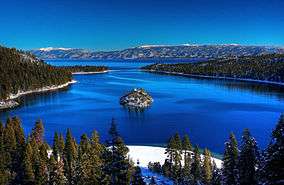
Lake Tahoe (/ˈtɑːhoʊ/) is a large freshwater lake in the Sierra Nevada of the United States. At a surface elevation of 6,225 ft (1,897 m), it straddles the border between California and Nevada, west of Carson City. Lake Tahoe is the largest alpine lake in North America.[3] Its depth is 1,645 ft (501 m), making it the second deepest in the United States after Crater Lake (1,945 ft (593 m)).[1] Additionally, Lake Tahoe is the sixth largest lake by volume in the United States at 122,160,280 acre·ft (150,682,490 dam3), behind the five Great Lakes.
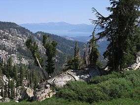
The lake was formed about 2 million years ago and is a part of the Lake Tahoe Basin with the modern lake being shaped during the ice ages. It is known for the clarity of its water and the panorama of surrounding mountains on all sides.[4] The area surrounding the lake is also referred to as Lake Tahoe, or simply Tahoe. More than 75% of the lake's watershed is national forest land, comprising the Lake Tahoe Basin Management Unit of the United States Forest Service.
Lake Tahoe is a major tourist attraction in both Nevada and California. It is home to a number of ski resorts, summer outdoor recreation, and tourist attractions. Snow and skiing are a significant part of the area's economy and reputation.[5][6] Mountain and lake scenery are attractions throughout the year. The Nevada side also includes large casinos. Highways provide year-round access to the area.
Geography

Lake Tahoe is the second deepest lake in the U.S., with a maximum depth of 1,645 feet (501 m),[1][7] trailing Oregon's Crater Lake at 1,949 ft (594 m).[7] Tahoe is the 16th[8] deepest lake in the world, and the fifth deepest in average depth. It is about 22 mi (35 km) long and 12 mi (19 km) wide and has 72 mi (116 km) of shoreline and a surface area of 191 square miles (490 km2). Approximately two-thirds of the shoreline is in California.[9] The south shore is dominated by the lake's largest city, South Lake Tahoe, California, which adjoins the town of Stateline, Nevada, while Tahoe City, California, is located on the lake's northwest shore. Although highways run within sight of the lake shore for much of Tahoe's perimeter, many important parts of the shoreline lie within state parks or are protected by the United States Forest Service. The Lake Tahoe Watershed (USGS Huc 18100200) of 505 sq mi (1,310 km2) includes the land area that drains to the lake and the Lake Tahoe drainage divide traverses the same general area as the Tahoe Rim Trail.
Lake Tahoe is fed by 63 tributaries, which drain an area about the same size as the lake; half the water entering the lake is rain or snow falling directly on it.
The Truckee River is the lake's only outlet.[3] The Truckee flows northeast through Reno, Nevada, and into Pyramid Lake, Nevada, which has no outlet. Only one third of the water that leaves the lake leaves via the Truckee, however; the rest evaporates from the lake's vast surface. The flow of the Truckee River and the height of the lake are controlled by a dam at the outlet. The natural rim, at which the lake can be allowed to flow out through the dam, is at an elevation of 6,223 ft (1,897 m) above sea level. The maximum legal limit, to which the lake can be allowed to rise in order to store water, is at an altitude of 6,229.1 ft (1,898.6 m) above sea level.[10]
Natural history
Geology

The Lake Tahoe Basin was formed by vertical motion (normal) faulting. Uplifted blocks created the Carson Range on the east and the main Sierra Nevada crest on the west. Down-dropped blocks (grabens) created the Lake Tahoe Basin in between.[1] This kind of faulting is characteristic of the geology of the adjoining Great Basin to the east.
Lake Tahoe is the youngest of several extensional basins of the Walker Lane deformation zone that accommodates nearly 12 mm/yr of dextral shear between the Sierra Nevada-Great Valley Block and North America.[11][12]
Three principal faults form the Lake Tahoe basin: the West Tahoe Fault, aligned between Emerald Bay and Tahoe City, and which is the local segment of the Sierra Nevada Fault, extending on shore north and south of these localities;[13] the East Tahoe Fault, aligned along the eastern shoreline; and the North Tahoe Fault, which runs between the two others deep under the northern part of the lake.[14] The West Tahoe Fault appears to be the most active and potentially hazardous fault in the basin. A study in Fallen Leaf Lake, just south of Lake Tahoe, used seafloor mapping techniques to image evidence for paleoearthquakes on the West Tahoe and revealed the last earthquake occurred between 4,100 and 4,500 years ago.[15] Subsequent studies revealed submarine landslides in Fallen Leaf Lake and Lake Tahoe that are thought to have been triggered by earthquakes on the West Tahoe fault and the timing of these events suggests a recurrence interval of 3,000-4,000 years.[16]
Some of the highest peaks of the Lake Tahoe Basin that formed during the process of Lake Tahoe creation are Freel Peak at 10,891 feet (3,320 m), Monument Peak at 10,067 feet (3,068 m), Pyramid Peak at 9,984 feet (3,043 m) (in the Desolation Wilderness), and Mount Tallac at 9,735 feet (2,967 m).[1] The north shore boasts three peaks at 10,000+ feet: Mount Rose, Houghton and Relay peaks. Mt. Rose is a very popular hiking and backcountry skiing destination.
Eruptions from the extinct volcano Mount Pluto formed a dam on the north side. Melting snow filled the southern and lowest part of the basin to form the ancestral Lake Tahoe. Rain and runoff added additional water.[17]
Modern Lake Tahoe was shaped and landscaped by scouring glaciers during the Ice Ages, which began a million or more years ago.
Soils of the basin come primarily from andesitic volcanic rocks and granodiorite, with minor areas of metamorphic rock. Some of the valley bottoms and lower hill slopes are mantled with glacial moraines, or glacial outwash material derived from the parent rock. Sandy soils, rock outcrops and rubble and stony colluvium account for over 70% of the land area in the basin. The basin soils (in the < 2 mm fraction) are generally 65-85% sand (0.05–2.0 mm).
Given the great depth of Lake Tahoe, and the locations of the normal faults within the deepest portions of the lake, modeling suggests that earthquakes on these faults can trigger tsunamis. Wave heights of these tsunamis are predicted to be on the order of 10 to 33 ft (3 to 10 m) in height, capable of traversing the lake in just a few minutes.[18] A massive collapse of the western edge of the basin that formed McKinney Bay around 50,000 years ago is thought to have generated a tsunami/seiche wave with a height approaching 330 ft (100 m).[19]
Climate

Lake Tahoe has a dry-summer continental climate (Dsb in the Koeppen climate classification). Mean annual precipitation ranges from over 55 inches (1440 mm) for watersheds on the west side of the basin to about 26 inches (660 mm) near the lake on the east side of the basin. Most of the precipitation falls as snow between November and April, although rainstorms combined with rapid snowmelt account for the largest floods. There is a pronounced annual runoff of snowmelt in late spring and early summer, the timing of which varies from year to year. In some years, summertime monsoon storms from the Great Basin bring intense rainfall, especially to high elevations on the northeast side of the basin.
August is normally the warmest month at the Lake Tahoe Airport (elevation 6,254 ft, 1,906 m) with an average maximum of 78.7 °F (25.9 °C) and an average minimum of 39.8 °F (4.3 °C). January is the coolest month with an average maximum of 41.0 °F (5.0 °C) and an average minimum of 15.1 °F (−9.4 °C). The all-time maximum of 99 °F (37.2 °C) was recorded on July 22, 1988. The all-time minimum of −29 °F (−33.9 °C) was recorded on December 9, 1972, and February 7, 1989. Temperatures exceed 90 °F (32.2 °C) on an average of 2.0 days annually. Minimum temperatures of 32 °F (0 °C) or lower occur on an average of 231.8 days annually, and minimum temperatures of 0 °F (−17.8 °C) or lower occur on an average of 7.6 days annually. Freezing temperatures have occurred in every month of the year.[20][21]
| Climate data for Tahoe City, California (Elevation 6,230 ft, 1,899 m) | |||||||||||||
|---|---|---|---|---|---|---|---|---|---|---|---|---|---|
| Month | Jan | Feb | Mar | Apr | May | Jun | Jul | Aug | Sep | Oct | Nov | Dec | Year |
| Record high °F (°C) | 59 (15) |
60 (16) |
67 (19) |
74 (23) |
89 (32) |
90 (32) |
99 (37) |
94 (34) |
87 (31) |
80 (27) |
70 (21) |
60 (16) |
94 (34) |
| Average high °F (°C) | 38.6 (3.7) |
40.3 (4.6) |
44.0 (6.7) |
50.4 (10.2) |
59.6 (15.3) |
68.7 (20.4) |
77.9 (25.5) |
77.2 (25.1) |
69.8 (21) |
58.8 (14.9) |
46.9 (8.3) |
40.3 (4.6) |
56.0 (13.3) |
| Average low °F (°C) | 19.1 (−7.2) |
19.9 (−6.7) |
22.8 (−5.1) |
26.9 (−2.8) |
32.8 (0.4) |
38.6 (3.7) |
44.4 (6.9) |
43.7 (6.5) |
39.0 (3.9) |
32.3 (0.2) |
25.8 (−3.4) |
20.8 (−6.2) |
30.5 (−0.8) |
| Record low °F (°C) | −14 (−26) |
−15 (−26) |
−6 (−21) |
5 (−15) |
9 (−13) |
24 (−4) |
22 (−6) |
28 (−2) |
21 (−6) |
9 (−13) |
1 (−17) |
−16 (−27) |
−16 (−27) |
| Average precipitation inches (mm) | 5.97 (151.6) |
5.29 (134.4) |
4.12 (104.6) |
2.14 (54.4) |
1.20 (30.5) |
0.65 (16.5) |
0.26 (6.6) |
0.30 (7.6) |
0.59 (15) |
1.82 (46.2) |
3.57 (90.7) |
5.55 (141) |
31.47 (799.3) |
| Average snowfall inches (cm) | 45.9 (116.6) |
36.5 (92.7) |
35.2 (89.4) |
15.9 (40.4) |
3.7 (9.4) |
0.2 (0.5) |
0 (0) |
0 (0) |
0.3 (0.8) |
2.4 (6.1) |
15.5 (39.4) |
35.2 (89.4) |
190.7 (484.4) |
| Source: The Western Regional Climate Center[22] | |||||||||||||
Ecology
Vegetation in the basin is dominated by a mixed conifer forest of Jeffrey pine (Pinus jeffreyi), lodgepole pine (P. contorta), white fir (Abies concolor), and red fir (A. magnifica).[25] The basin also contains significant areas of wet meadows and riparian areas, dry meadows, brush fields (with Arctostaphylos and Ceanothus) and rock outcrop areas, especially at higher elevations. Ceanothus is capable of fixing nitrogen, but mountain alder (Alnus tenuifolia), which grows along many of the basin’s streams, springs and seeps, fixes far greater quantities, and contributes measurably to nitrate-N concentrations in some small streams. The beaches of Lake Tahoe are the only known habitat for the rare Lake Tahoe yellowcress (Rorippa subumbellata), a plant which grows in the wet sand between low- and high-water marks.[26]
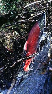
Each autumn, from late September through mid-October, mature kokanee salmon (Oncorhyncus nerka) transform from silver-blue color to a fiery vermilion, and run up Taylor Creek, near South Lake Tahoe. As spawning season approaches the fish acquire a humpback and protuberant jaw. After spawning they die and their carcasses provide a feast for gatherings of mink (Neovison vison), bears (Ursus americanus), and bald eagles (Haliaeetus leucocephalus). The non-native salmon were transplanted from the North Pacific to Lake Tahoe in 1944.[27]
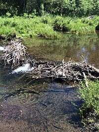
North American beaver (Castor canadensis) were re-introduced to the Tahoe Basin by the California Department of Fish and Wildlife and the U.S. Forest Service between 1934 and 1949. Descended from no more than nine individuals, 1987 beaver populations on the upper and lower Truckee River had reached a density of 0.72 colonies (3.5 beavers) per kilometer.[28] At the present time beaver have been seen in Tahoe Keys, Taylor Creek, Meeks Creek at Meeks Bay on the western shore, and Kings Beach on the north shore, so the descendants of the original nine beavers have apparently migrated around most of Lake Tahoe.[29][30] Recently novel physical evidence has demonstrated that beaver were native to the Sierra until at least the mid-nineteenth century, via radiocarbon dating of buried beaver dam wood uncovered by deep channel incision in the Feather River watershed.[31] That report was supported by a summary of indirect evidence of beaver including reliable observer accounts of beaver in multiple watersheds from the northern to the southern Sierra Nevada, including its eastern slope.[32] A specific documented record of beaver living historically in Lake Tahoe's North Canyon Creek watershed above Glenbrook includes a description of Spooner Meadow rancher Charles Fulstone hiring a caretaker to control the beaver population in the early 20th century.[33] A recent study of Taylor Creek showed that beaver dam removal decreased wetland habitat, increased stream flow, and increased total phosphorus pollutants entering Lake Tahoe - all factors which negatively impact the clarity of the lake's water.[34] In addition, beaver dams located in Ward Creek, located on the west shore of Lake Tahoe, were also shown to decrease nutrients and sediments traveling downstream.[34]
The lake's cold temperatures and extreme depth can slow the decomposition rate of organic matter. For example, a lost diver was found 17 years later at a depth of 300 feet (90 m), with his body preserved nearly perfectly.[35]
Human history
Native people
The area around Lake Tahoe was previously inhabited by the Washoe tribe of Native Americans. Lake Tahoe was the center and heart of Washoe Indian territory, including the upper valleys of the Walker, Carson and Truckee Rivers. The English name for Lake Tahoe derives from the Washo word "dá’aw," meaning "The Lake".[36]
Exploration and naming
Lt. John C. Frémont was the first person of European descent to see Lake Tahoe, during Fremont's second exploratory expedition on February 14, 1844.[37] John Calhoun Johnson, Sierra explorer and founder of "Johnson's Cutoff" (now U.S. Route 50), was likely the first white man to see Meeks Bay and from a peak above the lake he named Fallen Leaf Lake after his Indian guide. His first job in the west was in the government service, carrying the mail on snowshoes from Placerville to Nevada City, during which time he named the lake "Lake Bigler" in honor of California’s third governor John Bigler.
In 1853 William Eddy, the surveyor general of California, identified the lake as Lake Bigler. During the Civil War, Union advocates objected to the name, because Bigler was an ardent secessionist. Due to this, the U.S. Department of the Interior introduced the name Tahoe in 1862. Both names were in use: the legislature passed legislation declaring the official name to be Lake Bigler in 1870, while to most surveys and the general public it was known as Lake Tahoe.[38] The lake didn't receive its official and final designation as Lake Tahoe until 1945.
Mining era
Upon discovery of gold in the South Fork of the American River in 1848, thousands of gold seekers going west passed near the basin on their way to the gold fields. European civilization first made its mark in the Lake Tahoe basin with the 1858 discovery of the Comstock Lode, a silver deposit just 15 miles (24 km) to the east in Virginia City, Nevada. From 1858 until about 1890, logging in the basin supplied large timbers to shore up the underground workings of the Comstock mines. The logging was so extensive that loggers cut down almost all of the native forest.[39]
Development
Even in the mining era, the potential of the basin as a tourist destination was recognized. Tahoe City was founded in 1864 as a resort community for Virginia City.[39]
Public appreciation of the Tahoe basin grew, and during the 1912, 1913 and 1918 congressional sessions, congressmen tried unsuccessfully to designate the basin as a national park.[39]
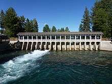
While Lake Tahoe is a natural lake, it is also used for water storage by the Truckee-Carson Irrigation District (TCID). The lake level is controlled by a dam built in 1913 at the lake's only outlet, the Truckee River, at Tahoe City. The 18-foot (5.5 m) high dam can increase the lake's capacity by 744,600 acre·ft (918,500,000 m3).[40]
During the first half of the 20th century, development around the lake consisted of a few vacation homes. The post-World War II population and building boom, followed by construction of gambling casinos in the Nevada part of the basin during the mid-1950s, and completion of the interstate highway links for the 1960 Winter Olympics held at Squaw Valley, resulted in a dramatic increase in development within the basin. From 1960 to 1980, the permanent residential population increased from about 10,000 to greater than 50,000, and the summer population grew from about 10,000 to about 90,000.[39] Since the 1980s, development has slowed due to controls on land use.
Government and politics
After a dispute that included gunshots exchanged between militia, in 1864, California and Nevada defined a partition that followed geographical coordinates: the state line runs east of the approximate center line of the lake; at 39 degrees north latitude, the state border runs southeasterly towards the Colorado River.
Unbeknownst to the negotiators, this compromise split Lake Tahoe: two-thirds for California, one-third for Nevada.[41][42] In California, Lake Tahoe is divided between Placer County and El Dorado County. In Nevada, Lake Tahoe is divided among Washoe County, Douglas County and Carson City (an independent city).
As the population grew and development expanded in the 1960s, the question of protecting the lake became more imperative. In 1969, The U.S. Congress and the California and Nevada State Legislatures created a unique compact to share resources and responsibilities. The Compact established the Tahoe Regional Planning Agency (TRPA), a bi-state agency charged with environmental protection of the Basin through land-use regulation and planning.[43] In 1980, the U.S. Congress amended the Compact with public law 96-551. The law designated a new agency, the Tahoe Transportation District (TTD), to facilitate and implement Basin and regional transportation improvements/additions for the protection, restoration and use of the lake. Schisms between both agencies and local residents have led to the formation of grass-roots organizations that hold to even stricter environmentalism.[44]
Historical locations
Lake Tahoe is also the location of several 19th and 20th century palatial homes of historical significance. The Thunderbird Lodge built by George Whittel Jr once included nearly 27 miles (43 km) of the Nevada shoreline. Vikingsholm was the original settlement on Emerald Bay and included an island teahouse and a 38-room home. The Ehrman Mansion is a summer home built by a former Wells Fargo president in Sugar Pine Point and is now a state park.
Environmental issues
Water quality

Despite land-use planning and export of treated sewage effluent from the basin, the lake is becoming increasingly eutrophic (having an excessive richness of nutrients), with primary productivity increasing by more than 5% annually, and clarity decreasing at an average rate of 0.25 meters per year.[45] Until the early 1980s, nutrient-limitation studies showed that primary productivity in the lake was nitrogen-limited. Now, after a half-century of accelerated nitrogen input (much of it from direct atmospheric deposition), the lake is phosphorus-limited. Theodore Swift et al.,[46] concluded that "suspended inorganic sediments and phytoplanktonic algae both contribute significantly to the reduction in clarity, and that suspended particulate matter, rather than dissolved organic matter, are the dominant causes of clarity loss." The largest source of fine sediment particles to Lake Tahoe is urban stormwater runoff, comprising 72 percent of the total fine sediment particle load.[47] The urban uplands also provide the largest opportunity to reduce fine sediment particle and phosphorus contributions to the lake. Historic clarity of approximately 30 meters can be achieved with total reduction of approximately 75 percent from urban sources.[48]
Historically, the clarity of Lake Tahoe continued to decrease through 2010, when the average Secchi depth, 64.4 feet, was the second lowest ever recorded (the lowest was 64.1 feet in 1997). This represented a decrease of 3.7 feet from the previous year.[49] However, the lake's clarity increased from 2011 to 2014, improving by nearly 20 percent.[50][51]
A water quality study by the Lahontan Water Quality Control Board and the Nevada Division of Environmental Protection determined the largest source of fine sediment particles, 71 percent is developed area (urban) erosion and run-off, much of it associated with transportation infrastructure and services.[52] Recent research has shown that the urban uplands also provide the largest opportunity to reduce fine sediment particle and phosphorus contributions to the lake. Historic clarity of approximately 30 meters can be achieved with total reduction of approximately 75 percent from urban sources.
Lake Tahoe is a tributary watershed drainage element within the Truckee River Basin, and its sole outlet is the Truckee River, which continues on to discharge to Pyramid Lake. Because of the sensitivity of Truckee River water quality (involving two protected species, the cui-ui[53] sucker fish and the Lahontan cutthroat trout), this drainage basin has been studied extensively. The primary investigations were stimulated by the U.S. Environmental Protection Agency, who funded the development of the DSSAM model to analyze water quality below Lake Tahoe.
Lake Tahoe never freezes.[54] Since 1970, it has mixed to a depth of at least 1,300 ft (400 m) a total of 6 or 7 times. Dissolved oxygen is relatively high from top to bottom. Analysis of the temperature records in Lake Tahoe has shown that the lake warmed (between 1969 and 2002) at an average rate of 0.015 °C per year. The warming is caused primarily by increasing air temperatures, and secondarily by increasing downward long-wave radiation. The warming trend is reducing the frequency of deep mixing in the lake, and may have important effects on water clarity and nutrient cycling.
Ecosystem changes
Since the 1960s, the Lake's food web and zooplankton populations have undergone major changes. In 1963–65, opossum shrimp (Mysis diluviana) were introduced to enhance the food supply for the introduced Kokanee salmon (Oncorhynchus nerka). The shrimp began feeding on the lake's cladocerans (Daphnia and Bosmina), and their populations virtually disappeared by 1971.[55] The shrimp provide a food resource for salmon and trout, but also compete with juvenile fish for zooplankton. Since the 1970s, the cladoceran populations have somewhat recovered, but not to former levels. Since 2006, goldfish have been observed in the lake, where they have grown to "giant size", behaving like an invasive species. They may have descended from former pets which owners dumped or escaped, when used as fishing bait.[56]
In June 2007, the Angora Fire burned approximately 3,100 acres (1,300 ha) throughout the South Lake Tahoe area. While the impact of ash on the lake's ecosystem is predicted to be minimal, the impact of potential future erosion is not yet known.[57]
Environmental protection

Until recently, construction on the banks of the Lake had been largely under the control of real estate developers. Construction activities have resulted in a clouding of the lake's blue waters. Currently, the Tahoe Regional Planning Agency is regulating construction along the shoreline.[58] (and has won two Federal Supreme Court battles over recent decisions). These regulations are unpopular with many residents, especially those in the Tahoe Lakefront Homeowners Association.[59]
The League to Save Lake Tahoe (Keep Tahoe Blue) has been an environmental watchdog in the Lake Tahoe Basin for 50 years.[60] Founded when a proposal to build a four-lane highway around the lake—with a bridge over the entrance to Emerald Bay—was proposed in 1957, the League has opposed many development projects in the area, which it alleges were environmentally harmful. The League embraces responsible and diversified use of the Lake's resources while protecting and restoring its natural attributes.[61]
Since 1980, the Lake Tahoe Interagency Monitoring Program (LTIMP) has been measuring stream discharge and concentrations of nutrients and sediment in up to 10 tributary streams in the Lake Tahoe Basin, California-Nevada. The objectives of the LTIMP are to acquire and disseminate the water quality information necessary to support science-based environmental planning and decision making in the basin. The LTIMP is a cooperative program with support from 12 federal and state agencies with interests in the Tahoe Basin. This data set, together with more recently acquired data on urban runoff water quality, is being used by the Lahontan Regional Water Quality Control Board to develop a program (mandated by the Clean Water Act) to limit the flux of nutrients and fine sediment to the Lake.
UC Davis remains a primary steward of the lake. The UC Davis Tahoe Environmental Research Center is dedicated to research, education and public outreach, and to providing objective scientific information for restoration and sustainable use of the Lake Tahoe Basin.[62] Each year, it produces a well-publicized "State of the Lake" assessment report.

Tourist activities
Much of the area surrounding Lake Tahoe is devoted to the tourism industry and there are many restaurants, ski slopes, golf courses and casinos catering to visitors.
Winter sports
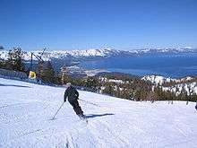

During ski season, thousands of people from all over Nevada and California, including Reno, Las Vegas, Los Angeles, San Diego, San Francisco, and Sacramento, flock to the slopes for downhill skiing. Lake Tahoe, in addition to its panoramic beauty, is well known for its blizzards.[5]
Some of the major ski areas in Tahoe include:
- Heavenly Mountain Resort: the largest ski area in California and Nevada, located near Stateline
- Squaw Valley: the second largest ski area, known for its hosting of the 1960 Winter Olympics, located near Tahoe City
- Alpine Meadows: a medium-sized ski area on the north shore only a few miles from Squaw Valley
- Diamond Peak: a small ski area located in Incline Village, Nevada
- Northstar at Tahoe: a popular north shore ski area
- Kirkwood Mountain Resort: a ski area which gets more snow than any other ski area in the Tahoe region
- Sierra-at-Tahoe: a medium-sized south shore ski area
- Boreal Mountain Resort: a small ski area on Donner Pass
- Sugar Bowl Ski Resort: a medium-sized ski area in Donner Pass
- Donner Ski Ranch: a very small ski area on Donner Pass
- Homewood Mountain Resort: a medium-sized ski area on the west shore
- Mount Rose Ski Resort: a medium-sized ski area north-east of the Lake, on Slide Mountain
The majority of the ski resorts in the Lake Tahoe region are on the northern end of the lake, near Truckee, California and Reno, Nevada. Kirkwood, Sierra-at-Tahoe and Heavenly are located on the southern side of the lake, 55–75 miles (90–120 km) from Reno. Scattered throughout Tahoe are public and private sled parks. Some, such as Granlibakken are equipped with rope tows to help sledders get up the hill.
Many ski areas around Tahoe also have snow tubing, such as Squaw Valley. Throughout Tahoe, cross-country skiing, snowmobile riding and snowshoeing are also popular.
Water sports

During late Spring to early Fall, the lake is popular for water sports and beach activities. The two cities most identified with the Lake Tahoe tourist area are South Lake Tahoe, California and the smaller Stateline; smaller centers on the northern shoreline include Tahoe City and Kings Beach.
Other popular activities include parasailing, jet ski rentals and eco-friendly paddle sport rentals. There are rental locations located around Lake Tahoe. Kayaking and stand up paddle boards have also become very popular.
Boating is a primary activity in Tahoe in the summer. The lake is home to one of the most prestigious wooden boat shows in the country, the Lake Tahoe Concours d'Elegance, held every August. There are lake front restaurants all over the lake, most equipped with docks and buoys (See the restaurants section). There are all sorts of boating events, such as sailboat racing, firework shows over the lake, guided cruises, and more. As an interstate waterway, Lake Tahoe is subject to the United States Coast Guard. Lake Tahoe is home to Coast Guard Station Lake Tahoe.[63]
SCUBA diving is popular at Lake Tahoe, with some dive sites offering dramatic drop-offs or wall dives. Diving at Lake Tahoe is considered advanced due to the increased risk of decompression sickness (DCS) while diving at such a high altitude.[64][65]
Fred Rogers became the first person to swim the length of Lake Tahoe in 1955, and Erline Christopherson became the first woman to do so in 1962.[66][67]
Hiking and bicycling
There are numerous hiking and mountain biking trails around the lake. They range widely in length, difficulty and popularity. One of the most famous of Tahoe's trails is the Tahoe Rim Trail, a 165-mile (270-km) trail that circumnavigates the lake. Directly to the west of the lake is the Granite Chief Wilderness, which provides great hiking and wilderness camping. Also, to the southwest is the very popular Desolation Wilderness. One of the most popular trailheads used to access these popular destinations is Eagle Lake Trailhead, located near Emerald Bay on Tahoe's west shore. The Flume Trail of the east shore is one of Mountain Biking Magazine's Top 10 Trails in the U.S. There are also many paved off-road bicycle paths that meander through communities on all sides of the lake.
Gambling

Gambling is legal on the Nevada side of Lake Tahoe. Casinos, each with a variety of slot machines and table games, are located on the South Shore in Stateline, and on the North Shore in Crystal Bay and Incline Village.
When Nevada legalized gambling in 1931, the first casino at the lake had already been open for years. First built on the North Shore in Crystal Bay by Robert Sherman in 1926,[68] the Calneva cabin became the property of Norman Henry Biltz and was sold to Bill Graham and Jim McKay in 1929.
The Calneva was rebuilt after a fire in 1937 and expanded several times, most noticeably in 1969 when the high-rise hotel was built. Along the way, Frank Sinatra owned the property in the early 1960s, shared his cabins with the likes of Sam Giancana and Marilyn Monroe, and sold out at the height of the area's popularity.
Other casinos at the North Shore include the Crystal Bay Club, first built in 1937 as the Ta-Neva-Ho; the Tahoe Biltmore, and the Nugget. The Hyatt Regency is found at Incline Village.
At South Shore, Bill Harrah purchased the Stateline Country Club, which had stood since 1931 and built Harrah's Tahoe. Other casinos include Hard Rock Hotel and Casino Lake Tahoe, Harveys Lake Tahoe, Montbleu, and the Lakeside Inn.
Transportation
Lake Tahoe can be reached directly by car, and indirectly by train or air. The nearest passenger train service is the Amtrak station in Truckee, and is served by Amtrak's train, the California Zephyr, which runs daily between Chicago and the San Francisco Bay Area. The closest scheduled passenger airline service is available via the Reno-Tahoe International Airport (RNO).
Highways


Visitors can reach Lake Tahoe under ideal conditions within two hours from the Sacramento area, one hour from Reno or thirty minutes from Carson City. In winter months, chains or snow tires are often necessary to reach Tahoe from any direction. Traffic can be heavy on weekends due to tourists if not also from weather.
The primary routes to Lake Tahoe are on Interstate 80 via Truckee, U.S. Route 50, and Nevada State Route 431 via Reno. Most of the highways accessing and encircling Lake Tahoe are paved two-lane mountain roads. US 50 is a four-lane highway (from the canyon of the South Fork American River at Riverton, over the Sierra Nevada at Echo Summit, and into the Lake Tahoe Basin, is a mainly two-lane road) passing south of the lake and along part of the eastern shore.
California State Route 89 follows the western shore of the lake through the picturesque wilderness and connects camping, fishing and hiking locations such as those at Emerald Bay State Park, DL Bliss State Park and Camp Richardson. Farther along are communities such as Meeks Bay and Tahoe City. Finally, the highway turns away from the lake and heads northwest toward Truckee.
California State Route 28 completes the circuit from Tahoe City around the northern shore to communities such as Kings Beach, Crystal Bay, and into Incline Village, Nevada where the road becomes Nevada State Route 28. Route 28 returns along the eastern shore to US 50 near Spooner Lake.
Major area airports
- Reno-Tahoe International Airport/KRNO (Reno, Nevada)
- Sacramento International Airport/KSMF (Sacramento, California)
- Lake Tahoe Airport/KTVL (South Lake Tahoe, California)
- Truckee-Tahoe Airport/KTRK (Truckee, California)
- Minden-Tahoe Airport/KMEV (Minden, Nevada)
Communities

California
- Carnelian Bay #3
- Dollar Point #4
- Kings Beach #1
- Sunnyside-Tahoe City #5
- Tahoe Vista #2
- Tahoma (partially in El Dorado County) #6
- South Lake Tahoe #7
- Tahoma (partially in Placer County) #6
Nevada
- Carson City #14
- Glenbrook #13
- Lakeridge #11
- Logan Creek #12
- Round Hill Village #8
- Skyland #10
- Stateline #17
- Zephyr Cove #9
- Crystal Bay #16
- Incline Village #15
In the media
The Ponderosa Ranch of the TV series Bonanza was formerly located on the Nevada side of Lake Tahoe.[69] The opening sequence of the TV series was filmed at the McFaul Creek Meadow, with Mount Tallac in the background. In September 2004 the Ponderosa Ranch closed its doors, after being sold to developer David Duffield for an undisclosed price.[70][71]
The 1974 film The Godfather Part II used the lakeside estate Fleur de Lac as the location of several scenes, including the elaborate First Communion celebration, the Senator's shakedown attempt of Michael, the assassination attempt on Michael, Michael disowning Fredo, Carmela Corleone's funeral, Fredo's death while fishing, and the closing scene of Michael sitting alone outside. Fleur de Lac, on the western California shore of Lake Tahoe, was formerly the Henry Kaiser estate. The surrounding lakeside area has been developed into a private gated condominium community and some of the buildings of the "Corleone compound" still exist, including the boathouse.[72]
The 2014 film Last Weekend, starring Patricia Clarkson and directed by Tom Dolby and Tom Williams, used the west shore lakefront home of Ray and Dagmar Dolby as the primary location for its interiors and exteriors. The house, built in 1929, was also the site for the exteriors for A Place in the Sun, starring Elizabeth Taylor and Montgomery Clift.[73]
See also
Notes
- 1 2 3 4 5 6 7
 This article incorporates public domain material from the United States Geological Survey document: "Facts About Lake Tahoe". Retrieved October 26, 2008.
 - ↑ van der Leeden; Troise; Todd (1990), The Water Encyclopedia (2nd ed.), Chelsea, MI: Lewis Publishers, p. 198–200
- 1 2 "Amazing Lake Tahoe". Lake Tahoe Visitors Authority. Archived from the original on January 4, 2010. Retrieved October 26, 2008.
- ↑ "Water Quality". The League To Save Lake Tahoe. Retrieved October 26, 2008.
- 1 2 "Lake Tahoe Resorts Winter sports". Porters Tahoe. Archived from the original on 2012-01-03. Retrieved October 26, 2008.
- ↑ Munson, Jeff (October 21, 2008). "In rocky economy, ski-resort jobs are seen as more than free passes". Nevada Appeal. Retrieved October 29, 2008.
- 1 2 "The World's Deepest Lakes" (PDF). US Department of the Interior: National Park Service. Retrieved October 31, 2008.
- ↑ "Deepest Lake in the World Deepest Lake in the United States". Geology.com. Retrieved October 31, 2008.
- ↑ "Lake Tahoe Trivia" (Press release). Lake Tahoe Visitors Authority. June 10, 2005. Archived from the original on February 22, 2009. Retrieved October 26, 2008.
- ↑ "USGS - National Water Information System". Retrieved 2016-04-14.
- ↑ Oldow, J.S.; Aiken, C.L.V.; Hare, J. L.; Ferguson, J. F.; Hardyman, R. F. (January 2001). "Active displacement transfer and differential block motion within the central Walker Lane, western Great Basin". Geology. 29 (1): 19–22. Bibcode:2001Geo....29...19O. doi:10.1130/0091-7613(2001)029<0019:ADTADB>2.0.CO;2. ISSN 0091-7613.
- ↑ Unruh, Jeffrey; Humphrey, James; Barron, Andrew (April 2003). "Transtensional model for the Sierra Nevada frontal fault system, eastern California". Geology. 31 (4): 327–330. Bibcode:2003Geo....31..327U. doi:10.1130/0091-7613(2003)031<0327:TMFTSN>2.0.CO;2. ISSN 0091-7613.
- ↑ Perlman, David (September 3, 2012). "New tool to dig up fresh quake clues". San Francisco Chronicle.
- ↑ "California-Nevada Fault Map centered at 39°N,120°W". USGS. Archived from the original on 2011-06-23. Retrieved 2012-09-18.
- ↑ Brothers, D.S.; Kent, G.M.; Driscoll, N. W.; Smith, S. B.; et al. (April 2009). "New Constraints on Deformation, Slip Rate, and Timing of the Most Recent Earthquake on the West Tahoe-Dollar Point Fault, Lake Tahoe Basin, California". Bulletin of the Seismological Society of America. 99 (2a): 499–519. Bibcode:2009BuSSA..99..499B. doi:10.1785/0120080135.
- ↑ Maloney, J.M.; Noble, P.J.; Driscoll, N.W.; Kent, G.M.; et al. (2013). "Paleoseismic history of the Fallen Leaf segment of the West Tahoe-Dollar Point fault reconstructed from slide deposits in the Lake Tahoe Basin, California-Nevada". Geosphere. 9 (4): 1065–1090. Bibcode:2013Geosp...9.1065M. doi:10.1130/GES00877.1.
- ↑ "Frequently Asked Questions about Lake Tahoe and the Basin". Lake Tahoe Basin Management Unit. Forest Service, U.S. Department of Agriculture. Archived from the original on May 10, 2009. Retrieved June 20, 2007.
- ↑ Ichinose, G.A.; Anderson, J.G.; Satake, K.; Schweickert, R.A.; Lahren, M.M. (April 2000). "The potential hazard from tsunami and seiche waves generated by large earthquakes within Lake Tahoe, California-Nevada". Geophysical Research Letters. 27 (8): 1203–1206. Bibcode:2000GeoRL..27.1203I. doi:10.1029/1999GL011119.
- ↑ Gardner, J.V. (July 2000). "The Lake Tahoe debris avalanche". 15th Annual Geological Conference. Geological Society of Australia.
- ↑ "Tahoe, California – Climate Summary". Desert Research Institute. Retrieved October 31, 2008. (1903–2007 climate data)
- ↑ "Climate Data – North Lahontan Hydrologic Region". State of California, Department of Water Resources. Retrieved October 31, 2008. (30-year climate data)
- ↑ "Seasonal Temperature and Precipitation Information". Western Regional Climate Center. Retrieved April 13, 2013.
- ↑ Ryan L. Lokteff; Brett B. Roper & Joseph M. Wheaton (2013). "Do Beaver Dams Impede the Movement of Trout?" (PDF). Transactions of the American Fisheries Society. 142 (4): 1114–1125. doi:10.1080/00028487.2013.797497. Retrieved 2014-06-17.
- ↑ Eric Collier (1959). Three Against the Wilderness. Victoria, British Columbia: Touchwood. p. 288. ISBN 1-894898-54-0.
- ↑ "Trees Indigenous to Lake Tahoe". Northstar-at-Tahoe Resort. Archived from the original on 2012-01-03. Retrieved October 31, 2008.
- ↑ "The Nature Conservancy: ''Rorippa subumbellata''". Natureserve. Retrieved November 15, 2011.
- ↑ Marcia Williamson (Oct 1992). "Tahoe's drama of the kokanee". Sunset Magazine. Retrieved May 8, 2010.
- ↑ Beier P, Barrett RH (1989). "Beaver Distribution in the Truckee River Basin, California" (PDF). California Fish and Game. Retrieved January 17, 2010.
- ↑ "The Beavers of the Truckee River". Tahoe Arts and Mountain Culture. July 20, 2009. Retrieved August 16, 2010.
- ↑ Keaven Van Lom (January 16, 2010). "This is Wildlife Management in the 21st century?". Moonshine Ink. Archived from the original on 2012-01-03. Retrieved August 16, 2010.
- ↑ James, C. D.; Lanman, R. B. (Spring 2012). "Novel physical evidence that beaver historically were native to the Sierra Nevada". California Fish and Game. 98 (2): 129–132. Retrieved 2014-06-17.
- ↑ R. B. Lanman; H. Perryman; B. Dolman; Charles D. James (Spring 2012). "The historical range of beaver in the Sierra Nevada: a review of the evidence". California Fish and Game. 98 (2): 65–80. Retrieved 2014-06-17.
- ↑ 2ndNature; Huffman & Carpenter, Inc. (April 2010). North Canyon Creek Restoration Project: Phase I Final Report (PDF) (Report). U.S. Army Corps of Engineers Sacramento District. Retrieved September 6, 2016.
- 1 2 Sarah Muskopf (October 2007). The Effect of Beaver (Castor canadensis) Dam Removal on Total Phosphorus Concentration in Taylor Creek and Wetland, South Lake Tahoe, California (Thesis). Humboldt State University, Natural Resources. Retrieved 2012-09-29.
- ↑ "At Lake Tahoe, a scuba diver's body is recovered after 17 years". Los Angeles Times. 2011-08-09.
- ↑ "Lake Tahoe Basin Mgt Unit - History & Culture". www.fs.usda.gov. Retrieved 2016-01-15.
- ↑ "Lake Tahoe Facts and Figures". Tahoe Regional Planning Association. Archived from the original on 2012-01-03. Retrieved October 26, 2008.
- ↑ Erwin, Gudde (2004). California Place Names: The origin and etymology of current geographical names. Berkeley, CA: University of California Press. p. 121.
- 1 2 3 4 This article incorporates public domain material from the United States Geological Survey document: "Stream and Ground-Water Monitoring Program, Lake Tahoe Basin, Nevada and California". Retrieved November 24, 2009.
- ↑ "Water Delivery Projects and Facilities". Lahontan Basin Area Office. U.S. Bureau of Reclamation. Retrieved November 24, 2009.
- ↑ "Truckee River Chronology". Nevada Department of Conservation & Natural Resources. Archived from the original on August 25, 2010. Retrieved October 26, 2008.
- ↑ Brean, Henry (April 27, 2009). "Four Corners mistake recalls long border feud between Nevada, California". Las Vegas Review-Journal. Retrieved April 27, 2009.
- ↑ "Tahoe Regional Planning Agency".
- ↑ "Friends of Lake Tahoe".
- ↑ Lahontan Regional Water Quality Board. "Lake Tahoe Basin Characterization & Assessment of Exemplary Programs for Water Quality Crediting and Trading Feasibility Analysis". Water Quality Crediting and Trading Feasibility Study. Kieser and Associates. Archived from the original (PDF) on 2012-01-03. Retrieved December 6, 2011.
- ↑ Swift, Theodore J; Perez-Losada, Joaquim; Schladow, S. Geoffrey; Reuter, John E; Jassby, Alan D; Goldman, Charles R (2006). "Water clarity modeling in Lake Tahoe: Linking suspended matter characteristics to Secchi depth". Aquat. Sci. 68: 1–15. doi:10.1007/s00027-005-0798-x.
- ↑ "Lake Tahoe Total Maximum Daily Load Report" (PDF). California Regional Water Quality Control Board, Lahontan Region. 2010.
- ↑ Sahoo, G. B.; Schladow, S. G.; Reuter, J. E. (2010). "Effect of sediment and nutrient loading on Lake Tahoe optical conditions and restoration opportunities using a newly developed lake clarity model". Water Resources Research. 46 (10): n/a. Bibcode:2010WRR....4610505S. doi:10.1029/2009WR008447. Archived from the original on January 20, 2012.
- ↑ "Tahoe: State of the Lake Report". UC Davis Tahoe Environmental Research Center. 2011. Archived from the original (PDF) on 2012-01-03.
- ↑ "Lake Tahoe's clarity shows gains for a second year".
- ↑ "Drought helps boost Lake Tahoe's clarity".
- ↑ http://ndep.nv.gov/bwqp/tahoe3.htm
- ↑ Gimenez Dixon (1996). "Chasmistes cujus". IUCN Red List of Threatened Species. Version 2006. International Union for Conservation of Nature. Retrieved May 10, 2006. Listed as Critically Endangered (CR B1+2b v2.3)
- ↑ "Lake Tahoe Facts". Heavenly Mountain Resort. Retrieved October 3, 2010.
- ↑ Goldman, C.R.; M.D. Morgan; S.T. Threlkeld; N. Angeli (1979). "A Population Dynamics Analysis of the Cladoceran Disappearance from Lake Tahoe, California-Nevada". Limnology and Oceanography. 24 (2): 289–297. doi:10.4319/lo.1979.24.2.0289.
- ↑ Laila Kearney. Goldfish influx threatens to cloud pristine Lake Tahoe waters. Reuters Feb 22, 2013.
- ↑ Carl T. Hall (June 26, 2007). "Raging Tahoe Fire's Roots: 150 Years of Mismanagement". San Francisco Chronicle. p. A–1.
- ↑ "Construction Monitoring". Tahoe Regional Planning Agency. Archived from the original on 2011-05-14.
- ↑ "About TLOA". Tahoe Lakefront Homeowners Association. Archived from the original on 2012-04-26. Retrieved December 6, 2011.
- ↑ Baunfire.com. "Keep Tahoe Blue – History". Keep Tahoe Blue. Retrieved November 15, 2011.
- ↑ "History of The League to Save Lake Tahoe". Keep Tahoe Blue. Retrieved September 25, 2008.
- ↑ "Tahoe Environmental Research Center".
- ↑ Hartman, Joanna. "Tahoe Coast Guard changes command". tahoe.com. Sierra Sun. Archived from the original on December 7, 2008. Retrieved October 26, 2008.
- ↑ Egi, S. M.; Brubakk, Alf O. (1995). "Diving at altitude: a review of decompression strategies". Undersea and Hyperbaric Medicine. 22 (3): 281–300. ISSN 1066-2936. OCLC 26915585. PMID 7580768. Retrieved March 11, 2009.
- ↑ "Altitude Diving". Retrieved October 26, 2008.
- ↑ "First person to swim length of Lake Tahoe reflects back on 1955 feat". Tahoe Daily Tribune. Retrieved 17 September 2014.
- ↑ "First woman to swim the length of Lake Tahoe recalls 1962 adventure". Carson Now. Carson City Nevada News. Retrieved 17 September 2014.
- ↑ Moe, Al W. (2008). The Roots of Reno. p. 65. ISBN 9781439211991.
- ↑ "Bonanza". TVLand. Viacom International Inc. Retrieved October 31, 2008.
- ↑ "Ponderosa Ranch". TV Acres. Retrieved November 15, 2011.
- ↑ "Bonanza - Ponderosa Ranch". GoCalifornia.about.com. September 27, 2004. Retrieved November 15, 2011.
- ↑ "Fleur de Lac Estates". Fleur du Lac Estates Home Owners Association. Retrieved May 8, 2012.
- ↑ "Last Weekend' revives 1951 film site' - San Francisco Chronicle". Retrieved June 1, 2014.
References
- Becker, Andrew. "The naming of Tahoe's mountains". Tahoe.com. Archived from the original on April 2, 2010. Retrieved November 1, 2008.
- Byron, Earl R.; Charles R. Goldman (January 1, 1989). "Land-Use and Water Quality in Tributary Streams of Lake Tahoe, California-Nevada". Journal of Environmental Quality. 18 (1): 84–88. doi:10.2134/jeq1989.00472425001800010015x. Retrieved November 1, 2008.
- Chang, C. C. Y.; J. S. Kuwabara; S. P. Pasilis (1992). "Phosphate and iron limitation of phytoplankton biomass in Lake Tahoe". Canadian Journal of Fisheries and Aquatic Science. 49 (6): 1206–1215. doi:10.1139/f92-136.
- Coats, R. N.; Goldman, C. R. (2001). "Patterns of nitrogen transport in streams of the Lake Tahoe basin, California-Nevada". Water Resour. Res. 37 (2): 405–415. Bibcode:2001WRR....37..405C. doi:10.1029/2000wr900219.
- Coats, R. N., J. Perez-Losada, G. Schladow, R. Richards and C. R. Goldman. 2006. The Warming of Lake Tahoe. Climatic Change (In Press).
- Crippen, J. R., and B. R. Pavelka. 1970. The Lake Tahoe basin, California-Nevada U.S. Geological Survey Water-Supply Paper 1972.
- Gardner, James V.; Larry A. Mayer; John Hughes-Clarke (January 16, 2003). "The bathymetry of Lake Tahoe, California-Nevada". Open-File Report 98-509. U.S. Geological Survey. Retrieved November 1, 2008.
- Goldman, C. R.; Jassby, A.; Powell, T. (1989). "Interannual fluctuations in primary production: meteorological forcing at two subalpine lakes". Limnol. Oceanogr. 34 (2): 310–323. doi:10.4319/lo.1989.34.2.0310.
- Goldman, C. R.; Jassby, A. D.; Hackley, S. H. (1993). "Decadal, interannual, and seasonal variability in enrichment bioassays at Lake Tahoe, California-Nevada, USA". Can. J. Fish. Aquat. Sci. 50 (7): 1489–1496. doi:10.1139/f93-170.
- Hatch, L. K.; Reuter, J. E.; Goldman, C. R. (2001). "Stream phosphorus transport in the Lake Tahoe Basin, 1989–1996". Environmental Monitoring and Assessment. 69 (1): 63–83. PMID 11393545.
- Jensen, Carol A.; North Lake Tahoe Historical Society (2012). Lake Tahoe’s West Shore. Charleston, S.C.: Arcadia Publishing. ISBN 9780738588919.
- Jassby, A. D.; Goldman, C. R.; Powell, T. M. (1992). "Trend, seasonality, cycle, and irregular fluctuations in primary productivity at Lake Tahoe, California-Nevada, USA". Hydrobiol. 246 (3): 195–203. doi:10.1007/bf00005697.
- Jassby, A. D.; Reuter, J. E.; Axler, R. P.; Goldman, C. R.; Hackley, S. H. (1994). "Atmospheric deposition of nitrogen and phosphorus in the annual nutrient load of Lake Tahoe (California-Nevada)". Water Resour. Res. 30 (7): 2207–2216. Bibcode:1994WRR....30.2207J. doi:10.1029/94wr00754.
- Jassby, A. D.; Goldman, C. R.; Reuter, J. E. (1995). "Long-term change in Lake Tahoe (California-Nevada, U.S.A.) and its relation to atmospheric deposition of algal nutrients". Arch. Hydrobiol. 135: 1–21.
- Jassby, A. D.; Goldman, C. R.; Reuter, J. E.; Richards, R. C. (1999). "Origins and scale dependence of temporal variability in the transparency of Lake Tahoe, California-Nevada". Limnol. Oceanog. 44 (2): 282–294. doi:10.4319/lo.1999.44.2.0282.
- Jassby, A.; Reuter, J.; Goldman, C. R. (2003). "Determining long-term water -quality change in the presence of climate variability: Lake Tahoe (U.S.A.)". Can. J. Fish. Aquat. Sci. 60 (12): 1452–1461. doi:10.1139/f03-127.
- Leonard, R. L.; Kaplan, L. A.; Elder, J. F.; Coats, R. N.; Goldman, C. R. (1979). "Nutrient Transport in Surface Runoff from a Subalpine Watershed, Lake Tahoe Basin, California". Ecological Monographs. 49 (3): 281–310. doi:10.2307/1942486. JSTOR 1942486.
- Nagy, M., 2003. Lake Tahoe Basin Framework Study Groundwater Evaluation Lake Tahoe Basin, California and Nevada. U.S. Army Corps of Engineers, Sacramento, CA.
- Naslas, G. D.; Miller, W. W.; Blank, R. R.; Gifford, G. F. (1994). "Sediment, nitrate, and ammonium in surface runoff from two Tahoe basin soil types". Water Resour. Bull. 30 (3): 409–417. doi:10.1111/j.1752-1688.1994.tb03300.x.
- Richards, R. C.; Goldman, C. R.; Byron, E.; Levitan, C. (1991). "The mysids and lake trout of Lake Tahoe: A 25-year history of changes in the fertility, plankton, and fishery of an alpine lake". Am. Fish. Soc. Symp. 9: 30–38.
- Sahoo, G. B., S. G. Schladow and J. E. Reuter, 2010. Effect of sediment and nutrient loading on Lake Tahoe optical conditions and restoration opportunities using a newly developed lake clarity model
- Schuster, S.; Grismer, M. E. (2004). "Evaluation of water quality projects in the Lake Tahoe Basin". Environmental Monitoring and Assessment. 90 (1–3): 225–242. doi:10.1023/b:emas.0000003591.52435.8d. PMID 15887374.
- Scott, E. B. 1957. The Saga of Lake Tahoe. Early Lore and History of the Lake Tahoe Basin
External links
| Wikivoyage has a travel guide for Lake Tahoe. |
| Wikimedia Commons has media related to: |
- Lake Tahoe Data Clearinghouse – USGS/Western Geographic Science Center
- US EPA's Lake Tahoe webpage
- Truckee River Watershed Council
- Tahoe Institute for Natural Science
- Lake Tahoe remote Meteorological Data Sites
- Lake Tahoe Watershed- California Rivers Assessment database
- Lake Tahoe at DMOZ
- Lake Tahoe Resource, University of Nevada, Reno Libraries
- Images of Lake Tahoe, University of Nevada, Reno Libraries
