Sacramento Executive Airport
| Sacramento Executive Airport | |||||||||||||||||||
|---|---|---|---|---|---|---|---|---|---|---|---|---|---|---|---|---|---|---|---|
|
2006 USGS Photo | |||||||||||||||||||
|
IATA: SAC – ICAO: KSAC – FAA LID: SAC – WMO: 72483 | |||||||||||||||||||
| Summary | |||||||||||||||||||
| Airport type | Public | ||||||||||||||||||
| Operator | Sacramento County | ||||||||||||||||||
| Location | Sacramento, California | ||||||||||||||||||
| Elevation AMSL | 24 ft / 7 m | ||||||||||||||||||
| Coordinates | 38°30′45″N 121°29′36″W / 38.51250°N 121.49333°WCoordinates: 38°30′45″N 121°29′36″W / 38.51250°N 121.49333°W | ||||||||||||||||||
| Map | |||||||||||||||||||
 KSAC Location of Sacramento Executive Airport | |||||||||||||||||||
| Runways | |||||||||||||||||||
| |||||||||||||||||||
| Helipads | |||||||||||||||||||
| |||||||||||||||||||
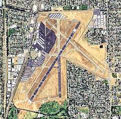
Sacramento Executive Airport (IATA: SAC, ICAO: KSAC, FAA LID: SAC) is a public airport three miles (5 km) south of downtown Sacramento, in Sacramento County, California. The airport covers 540 acres (219 ha) and has three runways (2 lit) and a helipad.
History
When it opened in 1930, Executive Airport was known as Sutterville Aerodrome. As the city-owned facility expanded, in 1941 construction was underway to pave and extend the airport's three runways.
The U.S. Army Air Corps took over the airport during World War II. After the war, control was returned to the city and the facility was renamed Sacramento Municipal Airport. During the late 1940s and early 1950s, improvements were made to parking and taxiway paving, water and sewer systems, and runway/taxiway lighting. The terminal building was built in 1955 along with some navigational aids and T-hangars.
During the airport's last summer of airline operations, the August 1967 Official Airline Guide (OAG) lists 22 weekday nonstops to San Francisco, 11 to Los Angeles, 7 to Reno, 2 to Medford, 2 to Marysville, and one each to Lake Tahoe, Klamath Falls and Oakland. Flights by Pacific Air Lines to the north continued to Chico, Eureka/Arcata, Crescent City and Portland, OR. Pacific Air Lines flight 771 (a Fairchild F-27) flew Reno-Lake Tahoe-Sacramento-San Francisco-San Jose-Fresno-Bakersfield-Burbank-Los Angeles-San Diego. United Airlines flight 224 was a Boeing 727-100 San Francisco-Sacramento-Reno-Denver-Chicago-New York La Guardia. Aircraft included Martin 4-0-4s and Fairchild F-27s (on Pacific Air Lines), Lockheed L-188 Electras (on Pacific Southwest Airlines (PSA) and Western Airlines), Boeing 727-100s (on PSA and United Airlines) and Boeing 720Bs (on Western); Western had one B720B nonstop a day to LAX.
In October 1967 the airlines moved to the new Sacramento Metropolitan Airport (SMF) and Sacramento Municipal Airport was renamed Sacramento Executive Airport. The County of Sacramento became the operator of both airports. Since then Executive Airport has become Northern California's primary general aviation airport.
Executive Airport is self-supporting, receiving no city, county, or tax money. All operating expenses are paid by users.
1972 Farrell's Ice Cream Parlour Crash
On September 24, 1972, a former military Canadair Sabre Mk. 5 jet in civilian ownership with US registration N275X was set to perform an air display at the Golden West Sport Aviation Show. Due to pilot error, the airplane failed to become airborne, went off the end of the runway, across a road and crashed into Farrell's Ice Cream Parlour. The explosion killed 22, twelve of those children, and injured 28 more people. The tragedy prompted closure of that runway, stricter regulations at the airport, and the opening of the Sacramento Firefighter's Burn Institute.[1] The Crossroads shopping center that housed the ice cream parlor was closed and rebuilt in 2002 as the Sacramento Public Safety Center, which is the main center for the Sacramento Fire Department and Sacramento Police Department.[2]
A memorial was constructed at the crash site and dedicated in March 2003.[2]
Facilities
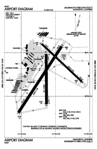
Sacramento Executive Airport is a general aviation airport with many facilities and services. In addition to an FAA tower, the airport has three paved runways (two lighted) and has tie-downs and hangar rentals. In 2004, aircraft operations averaged 370 per day.[3]
Over 20 businesses are located at Executive, providing: air charters; aircraft sales, rentals and repairs; flight training; pilot supplies; computer-based testing; and car rentals.
Located 10 minutes from downtown Sacramento, Executive is close to tourist attractions such as Old Sacramento, the State Capitol, Cal Expo State Fairgrounds, and Sleep Train Arena (home of the Sacramento Kings). The airport is also located near three public golf courses and major shopping areas.
Executive has three runways, two lighted: Runway 2/20 measures 5,503 ft x 150 ft. A Medium Intensity Approach Light System with Runway Alignment Indicator Lights (MALSR) is installed on Runway 2, while REIL and VASI are on Runway 20. The FAA contract control tower operates 06:00–21:00 (local).
Fuel is available from trucks or 24-hour self-serve credit card pumps, and plenty of tie-down and transient parking is available, the first six hours of which are free. Automobile parking in front of the terminal is also plentiful, and free for the first 72 hours.
Amenities
Amenities at Sacramento Executive Airport include:[4]
- Pilot's Lounge
- SACjet terminal with available meeting rooms
- Executive Airport terminal with available meeting rooms
- Disabled access, accommodations, and services throughout the facilities
- Restaurant in the terminal building
- Self-serve 100 LL Avgas, Jet A, tie-downs, hangar space, FBO and line services
- Contract control tower 6 a.m. to 9 p.m. daily (Serco)
- Free, short-term (72-hour) auto parking
Restaurants
Serving breakfast, lunch, and dinner, Aviators overlooks the airfield and can hold up to 190 people. They are available for banquet use and other events.
Cargo Carriers
| Airlines | Destinations |
|---|---|
| Ameriflight | Oakland, Portland, Reno |
See also
References
![]() This article incorporates public domain material from the Air Force Historical Research Agency website http://www.afhra.af.mil/.
This article incorporates public domain material from the Air Force Historical Research Agency website http://www.afhra.af.mil/.
- ↑ "The Crash at Farrell's Ice Cream Parlor in Sacramento, CA – September 24, 1972". Check Six. 2002. Retrieved December 13, 2006.
- 1 2 Pierleoni, Alan (September 24, 2012). "Somber event recalls Farrell's jet-crash disaster". Sacramento Bee. Retrieved February 8, 2014.
- ↑ AirNav info for Sac Executive
- ↑ About Executive Airport
External links
- Executive Airport (SAC) (official Sacramento County Airport System site)
- FAA Airport Master Record for SAC (Form 5010 PDF)
- FAA Airport Diagram (PDF), effective December 8, 2016
- Resources for this airport:
- AirNav airport information for KSAC
- ASN accident history for SAC
- FlightAware airport information and live flight tracker
- NOAA/NWS latest weather observations
- SkyVector aeronautical chart for KSAC
- FAA current SAC delay information
| Airfields |
| .svg.png) |
|---|---|---|
| Units | ||