Linda, California
| Linda | |
|---|---|
| census-designated place | |
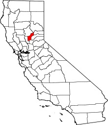
 Location in Yuba County and the state of California | |
 Linda Location in the United States | |
| Coordinates: 39°07′40″N 121°33′03″W / 39.12778°N 121.55083°WCoordinates: 39°07′40″N 121°33′03″W / 39.12778°N 121.55083°W | |
| Country |
|
| State |
|
| County | Yuba |
| Area[1] | |
| • Total | 8.546 sq mi (22.134 km2) |
| • Land | 8.546 sq mi (22.134 km2) |
| • Water | 0 sq mi (0 km2) 0% |
| Elevation | 69 ft (21 m) |
| Population (2010) | |
| • Total | 17,773 |
| • Density | 2,100/sq mi (800/km2) |
| Time zone | Pacific (PST) (UTC-8) |
| • Summer (DST) | PDT (UTC-7) |
| ZIP code | 95901 |
| Area code(s) | 530 |
| FIPS code | 06-41572 |
| GNIS feature ID | 1658963 |
Linda is a census-designated place (CDP) in Yuba County, California, United States. The population was 17,773 at the 2010 census, up from 13,474 at the 2000 census. Linda is located 2 miles (3.2 km) north-northwest of Olivehurst.[2]
Geography
Linda is located at 39°07′40″N 121°33′03″W / 39.12778°N 121.55083°W.[3]
According to the United States Census Bureau, the CDP has a total area of 8.5 square miles (22 km2), all of it land.
Climate
According to the Köppen Climate Classification system, Linda has a warm-summer Mediterranean climate, abbreviated "Csa" on climate maps.[4]
History
The townsite was originally laid out in 1850 and originally called Olivehurst by John Rose at the furthest navigable point on the Yuba River, on the south bank above Marysville.[2] The town at that site lasted only two years before moving to its present location.[2] The original site is buried under tailings from hydraulic mining.[2]
Demographics
2010
The 2010 United States Census[5] reported that Linda had a population of 17,773. The population density was 2,079.7 people per square mile (803.0/km²). The racial makeup of Linda was 9,973 (56.1%) White, 722 (4.1%) African American, 361 (2.0%) Native American, 2,304 (13.0%) Asian, 80 (0.5%) Pacific Islander, 3,029 (17.0%) from other races, and 1,304 (7.3%) from two or more races. Hispanic or Latino of any race were 5,779 persons (32.5%).
The Census reported that 17,752 people (99.9% of the population) lived in households, 21 (0.1%) lived in non-institutionalized group quarters, and 0 (0%) were institutionalized.
There were 5,440 households, out of which 2,700 (49.6%) had children under the age of 18 living in them, 2,635 (48.4%) were opposite-sex married couples living together, 1,012 (18.6%) had a female householder with no husband present, 485 (8.9%) had a male householder with no wife present. There were 542 (10.0%) unmarried opposite-sex partnerships, and 42 (0.8%) same-sex married couples or partnerships. 951 households (17.5%) were made up of individuals and 293 (5.4%) had someone living alone who was 65 years of age or older. The average household size was 3.26. There were 4,132 families (76.0% of all households); the average family size was 3.67.
The population was spread out with 5,929 people (33.4%) under the age of 18, 2,054 people (11.6%) aged 18 to 24, 4,937 people (27.8%) aged 25 to 44, 3,561 people (20.0%) aged 45 to 64, and 1,292 people (7.3%) who were 65 years of age or older. The median age was 27.9 years. For every 100 females there were 100.1 males. For every 100 females age 18 and over, there were 96.1 males.
There were 6,084 housing units at an average density of 711.9 per square mile (274.9/km²), of which 2,670 (49.1%) were owner-occupied, and 2,770 (50.9%) were occupied by renters. The homeowner vacancy rate was 4.3%; the rental vacancy rate was 9.5%. 8,453 people (47.6% of the population) lived in owner-occupied housing units and 9,299 people (52.3%) lived in rental housing units.
2000
As of the census[6] of 2000, there were 13,474 people, 4,072 households, and 3,005 families residing in the CDP. The population density was 2,388.3 people per square mile (922.4/km²). There were 4,483 housing units at an average density of 794.6 per square mile (306.9/km²). The racial makeup of the CDP was 54.87% White, 3.14% African American, 2.90% Native American, 18.38% Asian, 0.21% Pacific Islander, 13.64% from other races, and 6.87% from two or more races. Hispanic or Latino of any race were 22.15% of the population.
There were 4,072 households out of which 44.4% had children under the age of 18 living with them, 47.2% were married couples living together, 19.4% had a female householder with no husband present, and 26.2% were non-families. 19.1% of all households were made up of individuals and 6.2% had someone living alone who was 65 years of age or older. The average household size was 3.30 and the average family size was 3.80.
In the CDP the population was spread out with 37.4% under the age of 18, 11.6% from 18 to 24, 26.2% from 25 to 44, 17.0% from 45 to 64, and 7.8% who were 65 years of age or older. The median age was 26 years. For every 100 females there were 100.4 males. For every 100 females age 18 and over, there were 96.7 males.
The median income for a household in the CDP was $22,753, and the median income for a family was $24,925. Males had a median income of $25,513 versus $18,463 for females. The per capita income for the CDP was $9,826. About 32.6% of families and 37.6% of the population were below the poverty line, including 47.2% of those under age 18 and 10.2% of those age 65 or over.
Media
MySYtv.com provides television coverage of local events in the area.
Government
In the California State Legislature, Linda is in the 4th Senate District, represented by Republican Jim Nielsen, and in the 3rd Assembly District, represented by Republican James Gallagher.[7]
In the United States House of Representatives, Linda is in California's 3rd congressional district, represented by Democrat John Garamendi.[8]
References
- ↑ U.S. Census
- 1 2 3 4 Durham, David L. (1998). California's Geographic Names: A Gazetteer of Historic and Modern Names of the State. Clovis, Calif.: Word Dancer Press. p. 512. ISBN 1-884995-14-4.
- ↑ U.S. Geological Survey Geographic Names Information System: Linda, California
- ↑ Climate Summary for Linda, California
- ↑ "2010 Census Interactive Population Search: CA - Linda CDP". U.S. Census Bureau. Retrieved July 12, 2014.
- ↑ "American FactFinder". United States Census Bureau. Retrieved 2008-01-31.
- ↑ "Statewide Database". UC Regents. Retrieved January 12, 2015.
- ↑ "California's 3rd Congressional District - Representatives & District Map". Civic Impulse, LLC. Retrieved March 1, 2013.
External links
- South Yuba County Live Weather and Scanner Feed
- Edgewater Community Web Site
- U.S. Geological Survey Geographic Names Information System: Linda, California