Chula Vista, California
| Chula Vista, California | |||
|---|---|---|---|
| City | |||
| City of Chula Vista | |||
|
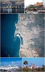
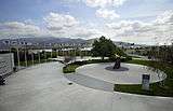
Images from top, left to right: Chula Vista Bayfront, Sleep Train Amphitheatre, HMS Surprise, Third Avenue in Downtown | |||
| |||
|
Nickname(s): The City of Allure Chula-juana[1] Lemon Capital of the World[2] | |||
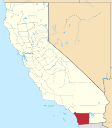
 Location of Chula Vista within San Diego County, California | |||
 Chula Vista, California Location in the United States | |||
| Coordinates: 32°37′40″N 117°2′53″W / 32.62778°N 117.04806°WCoordinates: 32°37′40″N 117°2′53″W / 32.62778°N 117.04806°W | |||
| Country |
| ||
| State |
| ||
| County | San Diego | ||
| Incorporated | November 28, 1911[3] | ||
| Government | |||
| • Type | Council-Manager | ||
| • City Council[4] |
Mayor Mary Casillas Salas Patricia Aguilar Pamela Bensoussan John McCann Steve Miesen | ||
| • City manager | Gary Halbert[5] | ||
| Area[6] | |||
| • City | 52.094 sq mi (134.925 km2) | ||
| • Land | 49.631 sq mi (128.545 km2) | ||
| • Water | 2.463 sq mi (6.380 km2) 4.73% | ||
| Elevation[7] | 66 ft (20 m) | ||
| Population (2010)[8][9] | |||
| • City | 243,916 | ||
| • Estimate (2014)[10] | 260,988 | ||
| • Rank |
2nd in San Diego County 14th in California 75th in the United States | ||
| • Density | 4,700/sq mi (1,800/km2) | ||
| • Metro | San Diego–Tijuana: 5,105,768 | ||
| Time zone | PST (UTC-8) | ||
| • Summer (DST) | PDT (UTC-7) | ||
| ZIP codes | 91909–91915, 91921 | ||
| Area code(s) | 619 | ||
| FIPS code | 06-13392 | ||
| GNIS feature IDs | 1660481, 2409461 | ||
| Website |
www | ||


Chula Vista (/ˌtʃuːlə ˈvɪstə/; Spanish: beautiful view[11][12] ) is the second largest city in the San Diego metropolitan area, the seventh largest city in Southern California, the fourteenth largest city in the state of California, and the 76th-largest city in the United States. The population was 243,916 as of the 2010 census.[9]
Located just 7.5 miles (12.1 km) from downtown San Diego and 7.5 miles (12.1 km) from the Mexican border in the South Bay region of the metropolitan area, the city is at the center of one of the richest economic and culturally diverse zones in the United States. Chula Vista is so named because of its scenic location between the San Diego Bay and coastal mountain foothills.
Founded in the early 19th century, fast population growth has recently been observed in the city. Located in the city is one of America's few year-round United States Olympic Training centers and popular tourist destinations include SleepTrain Amphitheatre, the Chula Vista marina, and the Living Coast Discovery Center, formerly known as the Chula Vista Nature Center.[13]
History
Early history
In the year 3000 BCE, people speaking the Yuman (Quechan) language began movement into the region from the Lower Colorado River Valley and southwestern Arizona portions of the Sonoran desert. Later the Kumeyaay tribe came to populate the land, on which the city sits today, who lived in the area for hundreds of years.[14]
In the year 1542 CE, a fleet of three Spanish Empire ships commanded by Juan Rodríguez Cabrillo, sailed into San Diego Harbor. Early explorations by Spanish conquistadors, such as these, led to Spanish claims of the land. The historic land on which Chula Vista sits became part of the 1795 land grant known as Rancho del Rey or The King's Ranch. The land eventually was renamed Rancho de la Nación.[14]
During the Mexican-American War, California was claimed by the United States, regardless of the California independence movement that had briefly swept the state. Though California was now under the jurisdiction of the United States, land grants were allowed to continue in the form of private property.[14]
The San Diego Land and Town Company developed lands of the Rancho de la Nación for new settlement. The town began as a five thousand acre development, with the first house being erected in 1887; by 1889, ten houses had been completed.[15] Chula Vista can be roughly translated from Spanish as "beautiful view."[14]
The 1888 completion of the Sweetwater Dam allowed for irrigation of Chula Vista farming lands. Chula Vista eventually became the largest lemon-growing center in the world for a period of time.[14]
20th century
The citizens of Chula Vista voted to incorporate on October 17, 1911. The State approved in November.[14]
In 1916, the Hercules Powder Company opened a 30-acre bayfront site, now known as Gunpowder point, which produced substances used to make cordite, a gun propellant used extensively by the British Armed Forces during World War I.[12] Although the Great Depression affected Chula Vista significantly, agriculture still provided considerable income for the residents. In 1931, the lemon orchards produced $1 million in revenue and the celery fields contributed $600,000.[14]
The relocation of Rohr Aircraft Corporation to Chula Vista in early 1941, just months before the attack on Pearl Harbor, changed Chula Vista. The land never returned to being orchard groves again. The population of post-World War II Chula Vista tripled from 5,000 residents in 1940 to more than 16,000 in 1950.[14] After the war, many of the factory workers and thousands of servicemen stayed in the area resulting in the huge growth in population. The last of the citrus groves and produce fields disappeared as Chula Vista became one of the largest communities in San Diego County.[14] From 1960 to 2013, the South Bay Power Plant, a 700 megawatt four boiler plant, occupied 115 acres (47 ha) of the Chula Vista waterfront.[16]
In 1944, the state of California attempted to seize land in Chula Vista owned by Kajiro Oyama, a legal Japanese resident who was then interned in Utah. Oyama was correctly charged with putting the property in his son Fred's name with the intent to evade the Alien Land Law because Fred was a native-born citizen. The case went to the U.S. Supreme Court as Oyama v. California where the court found that Kajiro's equal protection rights had been violated.
In January 1986, Chula Vista annexed the unincorporated community of Montgomery, which had previously rejected annexation in 1979 and 1982. At the time of the annexation the community was virtually surrounded by its larger neighbor.[17] Over the next few decades, Chula Vista continued to expand eastward. Plans called for a variety of housing developments such as Eastlake, Rancho del Rey and Otay Ranch neighborhoods.[12] In 1995, the United States Olympic Committee opened an Olympic Training Center in Eastlake on donated land;[18] it is the USOC's first master-planned facility and is adjacent to Lower Otay Reservoir.[19]
Camp Otay/Weber
During World War I and II The army maintained a base on what is now the corner of Main Street and Albany Avenue. It initially served as a border post during World War I, and was reestablished in December 1942. It was home to the 140th Infantry Regiment, 35th Infantry Division.[20] The regiment conducted war games against the Camp Lockett based 10th Cavalry, and were defeated.[21] The base was closed in February 1944, and the division went on to see combat in the European theater. All traces of the post have since been removed.[20]
21st century
In 2003, Chula Vista had 200,000 residents and was the second largest city in San Diego County.[22]
Chula Vista is growing at a fast pace,[12] with major developments taking place in the Otay Valley near the U.S. Olympic Training Center and Otay Lake Reservoir. Thousands of new homes have been built in the Otay Ranch, Lomas Verdes, Rancho Del Rey, Eastlake and Otay Mesa Areas.[23] The South Bay Expressway, a toll-road extension of state route 125, opened November 19, 2007, connecting freeways 805 and 905 with State Route 54.
On May 30, 2006 officials from Chula Vista and the San Diego Chargers met to potentially discuss building a new stadium that would serve as the home for the team. Yet, in June 2009 the Chargers removed Chula Vista as a possible location for a new stadium.[24] In 2009, Chula Vista - along with nine other second tier metropolitan area cities such as Hialeah and Southern California's Santa Ana - was ranked as one of the most boring cities in America by Forbes magazine;[25] citing the large population but rare mentions of the city in national media. A current development plan in Chula Vista is to develop the bayfront.
Geography

Owning up to its Spanish name origins - beautiful view - Chula Vista is located in the South Bay region of San Diego County, between the foothills of the Jamul and San Ysidro Mountains (including Lower Otay Reservoir) and San Diego Bay on its east and west extremes, and the Sweetwater River and Otay River at its north and south extremes.[26] In South Bay, Chula Vista has a large footprint and, aside from South San Diego, it is the largest geographic entity in the region.
According to the United States Census Bureau, the city covers an area of 52.1 square miles (135 km2), 49.6 square miles (128 km2) of it land, and 2.5 square miles (6.5 km2) or 4.73% of it water.
Ecological preserves
Chula Vista has within its city limits the Sweetwater Marsh unit of the San Diego Bay NWR.[27] It also maintains several city maintained open space areas.[28]
Neighborhoods
West Chula Vista
The original Chula Vista encompasses the area west of Hilltop Drive and north of L Street.[12] The community of Montgomery was annexed by the city, after several failed attempts, in 1986.[17] The community consist of most of the area south of L Street, west of Hilltop Drive and north of San Diego's city limit.[12]
East Chula Vista
Beginning in the late 1980s the planned communities of Eastlake, Otay Ranch, and Rancho del Rey began to develop in the annexed areas east of Interstate 805. These communities expanded upon the eastern annexations of the 1970s, including the area around Southwestern College.[12]
Climate
Like the rest of lowland San Diego County, Chula Vista has a semi-arid climate (Köppen BSh/BSk), with Mediterranean characteristics, though the winter rainfall is too low and erratic to qualify as an actual Mediterranean climate.[29]
| Climate data for Chula Vista, California (1981−2010 normals) | |||||||||||||
|---|---|---|---|---|---|---|---|---|---|---|---|---|---|
| Month | Jan | Feb | Mar | Apr | May | Jun | Jul | Aug | Sep | Oct | Nov | Dec | Year |
| Average high °F (°C) | 68.5 (20.3) |
68.1 (20.1) |
68.1 (20.1) |
69.4 (20.8) |
70.1 (21.2) |
72.0 (22.2) |
75.9 (24.4) |
77.8 (25.4) |
78.0 (25.6) |
75.7 (24.3) |
71.8 (22.1) |
67.4 (19.7) |
71.9 (22.2) |
| Average low °F (°C) | 45.8 (7.7) |
47.5 (8.6) |
50.3 (10.2) |
53.0 (11.7) |
57.5 (14.2) |
60.6 (15.9) |
64.5 (18.1) |
65.6 (18.7) |
63.2 (17.3) |
57.9 (14.4) |
50.2 (10.1) |
45.3 (7.4) |
55.1 (12.8) |
| Average precipitation inches (mm) | 1.87 (47.5) |
2.30 (58.4) |
1.70 (43.2) |
0.66 (16.8) |
0.09 (2.3) |
0.06 (1.5) |
0.03 (0.8) |
0.01 (0.3) |
0.14 (3.6) |
0.49 (12.4) |
0.98 (24.9) |
1.31 (33.3) |
9.64 (244.9) |
| Average precipitation days (≥ 0.01 in) | 5.0 | 6.6 | 5.6 | 3.1 | 0.7 | 0.5 | 0.3 | 0.3 | 0.6 | 1.9 | 3.3 | 4.5 | 32.4 |
| Source: NOAA[30] | |||||||||||||
Demographics
| Historical population | |||
|---|---|---|---|
| Census | Pop. | %± | |
| 1920 | 1,718 | — | |
| 1930 | 3,869 | 125.2% | |
| 1940 | 5,138 | 32.8% | |
| 1950 | 15,927 | 210.0% | |
| 1960 | 42,034 | 163.9% | |
| 1970 | 67,901 | 61.5% | |
| 1980 | 83,927 | 23.6% | |
| 1990 | 135,163 | 61.0% | |
| 2000 | 173,556 | 28.4% | |
| 2010 | 243,916 | 40.5% | |
| Est. 2015 | 265,757 | [31] | 9.0% |
| Year | Population (pop.) | Change in pop. (raw) | Change in pop. (%) |
|---|---|---|---|
| 2010 | 243,916[9] | +70,360 | +40.5% |
| 2000 | 173,556[33] | +38,393 | +28.4% |
| 1990 | 135,163[34] | +51,236 | +61.0% |
| 1980 | 83,927[35] | +16,026 | +23.6% |
| 1970 | 67,901[35] | +25,867 | +61.5% |
| 1960 | 42,034[12] | +26,107 | +163.9% |
| 1950 | 15,927[36] | +10,789 | +209.9% |
| 1940 | 5,138[12] | +1, 269 | +32.7% |
| 1930 | 3,869[12] | +2,151 | +125.2% |
| 1920 | 1,718[12] | +1,068 | +164.3% |
| 1910 | 650[12] | - | - |
2010
The 2010 United States Census[37] reported that Chula Vista had a population of 243,916. The population density was 4,682.2 people per square mile (1,807.8/km²). The racial makeup of Chula Vista was 130,991 (53.7%) White, 11,219 (4.6%) African American, 1,880 (0.8%) Native American, 35,042 (14.4%) Asian, 1,351 (0.6%) Pacific Islander, 49,171 (20.2%) from other races, and 14,262 (5.8%) from two or more races. Hispanic or Latino of any race were 142,066 persons (58.2%).
The Census reported that 242,180 people (99.3% of the population) lived in households, 656 (0.3%) lived in non-institutionalized group quarters, and 1,080 (0.4%) were institutionalized.
There were 75,515 households, out of which 36,064 (47.8%) had children under the age of 18 living in them, 42,153 (55.8%) were opposite-sex married couples living together, 12,562 (16.6%) had a female householder with no husband present, 4,693 (6.2%) had a male householder with no wife present. There were 3,720 (4.9%) unmarried opposite-sex partnerships, and 502 (0.7%) same-sex married couples or partnerships. 12,581 households (16.7%) were made up of individuals and 4,997 (6.6%) had someone living alone who was 65 years of age or older. The average household size was 3.21. There were 59,408 families (78.7% of all households); the average family size was 3.60.
The population was spread out with 68,126 people (27.9%) under the age of 18, 24,681 people (10.1%) aged 18 to 24, 70,401 people (28.9%) aged 25 to 44, 56,269 people (23.1%) aged 45 to 64, and 24,439 people (10.0%) who were 65 years of age or older. The median age was 33.7 years. For every 100 females there were 93.9 males. For every 100 females age 18 and over, there were 90.2 males.
There were 79,416 housing units at an average density of 1,524.5 per square mile (588.6/km²), of which 43,855 (58.1%) were owner-occupied, and 31,660 (41.9%) were occupied by renters. The homeowner vacancy rate was 2.4%; the rental vacancy rate was 4.5%. 143,330 people (58.8% of the population) lived in owner-occupied housing units and 98,850 people (40.5%) lived in rental housing units.
Late 20th century
In 2000, the city's population was 173,556. The racial make up of the city during the 2000 census was 55.1% White, 22.1% Other, 11% Asian, 5.8% of two or more races, 4.6% African American, 0.8% Native American, and 0.6% Pacific Islander. Hispanic or Latino of any race were 49.6%. Of these individuals, 28.7% were under the age of 18.[33][38]
In 1990, the city's population was 135,163. The racial make up of the city during the 1990 census was 67.7% White, 18.1% Other, 8.2% Asian, 4.5% African American, 0.6% Pacific Islander, and 0.6% Native American. Hispanic or Latino of any race were 37.2%. Of these individuals, 26% were under the age of 18.[34]
In 1980, the city's population was 83,927.[35] The racial make up of the city during the 1980 census was 83.1% White, 7.9% "Race, n.e.c.", 6.1% Asian and Pacific Islander, 2.1% African American, and 0.7% Native American. Persons of "Spanish Origin" made up 46.6% of the population.[39]
Economy
Chula Vista maintains a business atmosphere that encourages growth and development.[40] In the city, the small business sector amounts for the majority of Chula Vista's business populous.[40] This small business community is attributed to the city's growth and serves as a stable base for its economic engine.[40]

Tourism
Tourism serves as an economic engine for Chula Vista. The city has numerous dining, shopping, and cinema experiences.[41] As with many California cities, Chula Vista features many golf courses.[42] Some of the city's notable attractions included the Chula Vista Nature Center, Otay Valley Regional Park, Sleep Train Amphitheatre, OnStage Playhouse, the Chula Vista Marina, and the U.S. Olympic Training Center.[43] The Nature Center is home to interactive exhibits describing geologic and historic aspects of the Sweetwater Marsh and San Diego Bay. The Center has exhibits on sharks, rays, waterbirds, birds of prey, insects, and flora.[43] Otay Valley Regional Park is located partially within Chula Vista, where it covers the area of a natural river valley.
The marina at Chula Vista is located in South Bay including multiple marinas and being home to the Chula Vista Yacht Club. Sports fishing and whale watching charters operate the regional bay area. The Olympic Training Center assists current and future Olympic athletes in archery, rowing, kayaking, soccer (association football), softball, field hockey, tennis, track and field, and cycling.[43]
Chula Vista Center is the city's main shopping mall, opened in 1962.
Top employers
According to the City's 2014 Comprehensive Annual Financial Report,[44] the top employers in the city are:
| # | Employer | Employees |
|---|---|---|
| 1 | Sweetwater Union High School District | 4,096 |
| 2 | Chula Vista Elementary School District | 2,803 |
| 3 | United Technologies Aerospace Systems | 2,468 |
| 4 | Sharp Chula Vista Medical Center | 1,823 |
| 5 | Southwestern College | 1,699 |
| 6 | Walmart | 1,239 |
| 7 | City of Chula Vista | 1,154 |
| 8 | Scripps Mercy Hospital Chula Vista | 1,132 |
| 9 | Target | 659 |
| 10 | 24 Hour Fitness | 568 |
Culture
Chula Vista is home to OnStage Playhouse the only live theater in South Bay, San Diego.
Other points of interest and events include the Chula Vista Nature Center,[45] the J Street Harbor,[46] and the Third Avenue Village.[47] Downtown Chula Vista hosts a number of cultural events, including the famous Lemon Festival, Starlight Parade, and Chula Vista Rose Festival.
SleepTrain Amphitheatre is a performing arts theatre that was the areas first major concert music facility. OnStage theater stages high quality productions;[43] serving as a large contributor to the cultural arts setting in Chula Vista.
Sports
Chula Vista is the site of the Olympic Training Center.[48] The U.S. national rugby team practices at the OTC. Chula Vista is also home to Chula Vista FC which gained national attention with its 2015 Lamar Hunt U.S. Open Cup run.[49]
In 2009 Parkview Little League won the 2009 Little League World Series, earning the nickname "The Blue Bombers".
In 2013 Eastlake Little League won the American Championship at the 2013 Little League World Series.
Government
Municipal government
According to the city's most recent Comprehensive Annual Financial Report, the city's various funds had $322.9 million in Revenues, $287.5 million in expenditures, $1,232.7 million in total assets, $258.6 million in total liabilities, and $181.0 million in cash and investments.[50]
Presently the city council is led by Mayor Mary Casillas Salas. It has four other members: Patricia Aguilar, Pamela Bensoussan, John McCann, and Steve Miesen.[4]
Politics
Following 2011 redistricting by the California Citizens Redistricting Commission, the city's federal representation was split between the 51st and 53rd congressional districts.[51] In the California State Senate, the city remained entirely in the 40th Senate district. However, in the California State Assembly, it was split between the 79th and 80th Assembly districts.[52]
At the state and federal levels, Chula Vista is represented entirely by Democrats. In the State Senate, Chula Vista is represented by Democrat Ben Hueso.[53] In the Assembly, it is represented by Democrat Shirley Weber (79th district) and Democrat Lorena Gonzalez (80th district).[54] In the United States Senate, it is represented by Dianne Feinstein and Barbara Boxer, and in the United States House of Representatives, it is represented by Democrat Juan Vargas (51st district) and Democrat Susan Davis (53rd district).[55]
As of January 2013, out of the city's total population, 114,125 are registered to vote, up from 103,985 in 2009; the three largest registered parties in the city are the Democratic Party with 47,986, Republican Party with 31,633, and Decline to State with 29,692.[56] In a survey conducted by The Bay Area Center for Voting Research in 2004, it found that Chula Vista had a 50.59% conservative vote compared to a 49.41% liberal vote.[57]
Education
The Sweetwater Union High School District, headquartered in Chula Vista, serves as the primary secondary school district.[58] The Chula Vista Elementary School District, the largest K-6 district in the State of California with 44 campuses, serves publicly educated kindergarten through sixth grade students.[59]
Chula Vista is home to one of the four private colleges in San Diego County and is host to Southwestern College, a community college founded in 1961 that serves approximately 19,000 students annually.
The city has been trying since 1993 to get a state university located in the city. In 2012, the city acquired a 375-acre (152 ha) parcel of land in the Otay Lakes area intended for the development of a University Park and Research Center, and chose a master developer for the project.[60] State Assemblymember Shirley Weber has proposed that the state open a satellite or extension campus of the California State University system at the site, with the hope that it will grow into a full university.[61]
Media
Chula Vista is served by The Star-News (Chula Vista) and The San Diego Union-Tribune.
Transportation
Major freeways and highways
Chula Vista is served by multiple Interstates and California State Routes. Interstate 5 begins to the south of the city and runs through its western edge. Interstate 5 connects Chula Vista to North County and beyond to Greater Los Angeles and Northern California. Interstate 805 serves as a bypass to Interstate 5, linking to the latter interstate in Sorrento Valley. Interstate 905 runs from the Otay Mesa Port of Entry and is one of three auxiliary three-digit Interstate to meet an international border. State Route 54 and State Route 125 serve as highways to East County cities via north and northeastern corridors.
Notable people
Sister cities
Chula Vista has three sister cities, as designated by Sister Cities International.[62]
| City | Country |
|---|---|
| Cebu City | |
| Irapuato | |
| Odawara | |
References
- ↑ Bianca Bruno (October 6, 2010). "Growing up in "Chula-juana"". The Vista. Retrieved January 23, 2011.
Anne-Marie O'Connor (September 11, 2002). "Cross-Border Lifestyle Requires Patience". Los Angeles Times. Retrieved March 27, 2011.
Tom Greeley (April 15, 1985). "S.D. County's Cities Defy The Negatives, Accent The Positives". Los Angeles Times. Retrieved March 27, 2011. - ↑ "Heritage Museum". Public Library Chula Vista. City of Chula Vista. 2012. Archived from the original on December 21, 2012. Retrieved March 29, 2013.
"Happening Sunday, August 12th". Third Avenue Village. Archived from the original on July 3, 2013. Retrieved March 29, 2013.
"Agenda". San Diego Magazine. CurtCo/SDM LLC. 63 (5-8): 134. 2011. ISSN 0036-4045. Retrieved March 29, 2013.
Carpenter, Allan (1993). Facts about the Cities. Wilson. p. 31. ISBN 9780924208003. - ↑ "California Cities by Incorporation Date". California Association of Local Agency Formation Commissions. Archived from the original (Word) on November 3, 2014. Retrieved August 25, 2014.
- 1 2 "Mayor and Council". City of Chula Vista. Retrieved February 24, 2015.
- ↑ "City Manager's Home Page". City of Chula Vista. Archived from the original on November 20, 2014. Retrieved January 8, 2015.
- ↑ "2010 Census U.S. Gazetteer Files – Places – California". United States Census Bureau.
- ↑ "Chula Vista". Geographic Names Information System. United States Geological Survey. Retrieved October 22, 2014.
- ↑ Karen Kucher (March 8, 2011). "The faces of San Diego's changing demographics". U-T San Diego. Retrieved March 9, 2011.
- 1 2 3 "Chula Vista (city), California". Quick Facts. United States Census Bureau. 22 April 2015. Retrieved 22 May 2015.
Population, 2010 243,916
- ↑ "Annual Estimates of the Resident Population for Incorporated Places of 50,000 or More, Ranked by July 1, 2014 Population: April 1, 2010 to July 1, 2014 - United States -- Places of 50,000+ Population". American FactFinder. United States Census Bureau. July 1, 2014. Retrieved 22 May 2015.
- ↑ "About Chula Vista". City of Chula Vista. 2012. Archived from the original on March 8, 2013. Retrieved March 22, 2013.
Chula Vista means "beautiful view" and there is more to see and do here than you can imagine!
- 1 2 3 4 5 6 7 8 9 10 11 12 "Chula Vista in Perspective, Chapter 3" (PDF). Chula Vista General Plan. City of Chula Vista. December 13, 2005. Archived from the original (PDF) on March 21, 2012. Retrieved March 9, 2011.
- ↑ Lister, Priscilla (13 October 2014). "Bayfront walk in Chula vista has wildlife, public art". San Diego Union Tribune. Retrieved 28 October 2014.
"Living Coast Discovery Center". U.S. Fish & Wildlife Service. Department of the Interior. 6 March 2013. Retrieved 28 October 2014. - 1 2 3 4 5 6 7 8 9 "Brief History of Chula Vista". City of Chula Vista. City of Cula Vista. Archived from the original on November 5, 2010. Retrieved October 27, 2010.
- ↑ Nancy Ray (May 26, 1986). "Chula Vista, County's 2nd Largest City, Has Problem With Image". Los Angeles Times. Retrieved March 19, 2011.
- ↑ Katherine Poythress (January 30, 2013). "Imploding a bayfront fixture: If weather conditions cooperate, the now-defunct South Bay Power Plant in Chula Vista will be demolished on Saturday morning". San Diego Union. Retrieved February 9, 2013.
- 1 2 Keith A. Owens (January 3, 1986). "Montgomery Merging With City : Chula Vista Annexation Is Cause to Celebrate". Los Angeles Times. Retrieved March 19, 2011.
- ↑ Patrice Milkovich (August 8, 2004). "Chula Vista – where the world's best train". San Diego Union Tribune. Retrieved February 9, 2013.
- ↑ "Chula Vista". Olympic Training Centers/Sites & Tours. United States Olympic Committee. 2013. Archived from the original on February 6, 2013. Retrieved February 4, 2013.
- 1 2 Los Angeles District, Corps of Engineers. "Camp Otay". California State Military Museum. California State Military Department. Archived from the original on February 6, 2011. Retrieved April 21, 2011.
Schoenherr, Steve (28 March 2015). "Military Bases in the South Bay". SunnyCV. South Bay Historical Society. Retrieved 24 May 2015. - ↑ Bevil, Alexander D. (28 February 2014). "Cuyamaca Racho State Park Historic Background Study & Historic Inventory" (PDF). Department of Parks and Recreation. State of California. Retrieved 28 February 2014.
24 May 2015
- ↑ "Spotlight" (PDF). Office of the City Manager. City of Chula Vista. 2003. Archived from the original (PDF) on March 21, 2012. Retrieved March 19, 2011.
- ↑ "Horses Stampede Through Chula Vista Streets". KGTV. March 24, 2010. Retrieved March 19, 2011.
- ↑ "Chula Vista Out As Possible Chargers Stadium Site". 10News.com. Internet Broadcasting Systems, Inc. June 24, 2009. Retrieved August 13, 2009.
- ↑ Zumbrun, Joshua. "America's Most Boring Cities". Forbes. Retrieved January 5, 2009.
- ↑ "City of Chula Vista Drainage Basins" (PDF). Geographic Information System. City of Chula Vista. June 20, 2009. Archived from the original (PDF) on March 21, 2012. Retrieved March 19, 2011.
- ↑ "Sweetwater Marsh". U.S. Fish and Wildlife Service. United States Department of the Interior. July 9, 2010. Retrieved March 19, 2011.
- ↑ "Open Space". Public Works Operations. City of Chula Vista. Archived from the original on May 6, 2011. Retrieved March 19, 2011.
- ↑ "Mediterranean Climate". County Television Network. County of San Diego. Archived from the original on February 18, 2011. Retrieved March 19, 2011.
- ↑ "NOWData - NOAA Online Weather Data". National Oceanic and Atmospheric Administration. Retrieved August 20, 2012.
- ↑ "Annual Estimates of the Resident Population for Incorporated Places: April 1, 2010 to July 1, 2015". Retrieved July 2, 2016.
- ↑ "Census of Population and Housing". Census.gov. Archived from the original on May 11, 2015. Retrieved June 4, 2015.
- 1 2 "Chula Vista (city), California". State & County QuickFacts. U.S. Census Bureau. July 8, 2009. Retrieved March 9, 2011.
- 1 2 "Detailed Tables". 1990 Census of Population and Housing. U.S. Bureau of the Census. Retrieved 9 March 2011.
- 1 2 3 "Number of Inhabitants, California" (PDF). 1980 Census of Population. U.S. Bureau of the Census. March 1982. Retrieved March 9, 2011.
- ↑ Katz, Bruce; Robert E. Lang (2003). Redefining urban and suburban America: evidence from Census 2000. Washington, D.C.: Brookings Institution Press. p. 106. ISBN 978-0-8157-4859-5. Retrieved March 9, 2011.
- ↑ "2010 Census Interactive Population Search: CA - Chula Vista city". U.S. Census Bureau. Retrieved July 12, 2014.
- ↑ "DP-1. Profile of General Demographic Characteristics: 2000". Census 2000. U.S. Census Bureau. Retrieved March 9, 2011.
- ↑ "General Social and Economic Characteristics" (PDF). 1980 Census of Population. U.S. Bureau of the Census. July 1983. Retrieved March 9, 2011.
- 1 2 3 "City of Chula Vista: Small Business". City of Chula Vista. Archived from the original on September 27, 2011. Retrieved March 26, 2011.
- ↑ "Shopping in Chula Vista". City of Chula Vista. Archived from the original on June 29, 2011. Retrieved March 26, 2011.
- ↑ "Golf Courses in Chula Vista". City of Chula Vista. Archived from the original on September 3, 2011. Retrieved March 26, 2011.
- 1 2 3 4 "Chula Vista Attractions". City of Chula Vista. Archived from the original on August 29, 2011. Retrieved March 26, 2011.
- ↑ "City of Chula Vista, California Comprehensive Annual Financial Report, for the Year ended June 30, 2014". Retrieved July 11, 2015.
- ↑ "Nature Center". Community Services. City of Chula Vista. Archived from the original on November 7, 2009. Retrieved November 9, 2009.
- ↑ "Chula Vista Launch Ramp". SD Boating.com. Archived from the original on October 16, 2010. Retrieved November 9, 2009.
- ↑ "Third Avenue Village". Third Avenue Village Association. Retrieved November 7, 2009.
- ↑ "Chula Vista Olympic Training Ctr". United States Olympic Committee. Archived from the original on November 29, 2009. Retrieved November 9, 2009.
- ↑ "Chula Vista FC Aiming to Continue Upstart Beginning to 2015 USOC". ussoccer.com. Retrieved 27 September 2015.
- ↑ City of Chula Vista CAFR Archived May 28, 2009, at the Wayback Machine. Retrieved August 7, 2009
- ↑ Ken Stone; Hoa Quách; Steven Bartholow (July 29, 2011). "State GOP Chairman Slams Remap Plan as Favoring Democrats". LaMesa-MountHelix Patch. Retrieved July 3, 2012.
- ↑ "SWDB Web GIS". Statewide Database, Berkeley Law School. University of California, Berkeley. 2011. Retrieved January 25, 2013.
- ↑ "Senators". California State Senate.
- ↑ "Members". California State Assembly.
- ↑ "California's 53rd Congressional District - Representatives & District Map". Civic Impulse, LLC.
- ↑ "Report of Registration - State Reporting Districts" (PDF). Registrar of Voters. County of San Diego. January 14, 2013. Retrieved January 26, 2013.
- ↑ Jason Alderman; Gitanjali Gurudatt Borkar; Amanda Garrett; Lindsay Hogan; Janet Kim; Winston Le; Veronica Louie; Alissa Marque; Phil Reiff; Colin Christopher Richard; Peter Thai; Tania Wang; Craig Wickersham. "The Most Conservative and Liberal Cities in the United States" (PDF). The Bay Area Center for Voting Research. Retrieved July 8, 2012.
- ↑ "Sweetwater Union High School District". SUHSD. Archived from the original on March 28, 2010. Retrieved March 30, 2010.
- ↑ "Community" (PDF). 2011 Membership & Resource Guide. Chula Vista Chamber of Commerce. Retrieved July 25, 2011.
Located between the City of San Diego and United States/Mexico International Border, the Chula Vista Elementary School District is the largest K-6 district in the state
- ↑ Harvey, Katherine P. (December 17, 2012). "Chula Vista picks developer for university master plan". San Diego Union Tribune. Retrieved 5 September 2014.
- ↑ Bowler, Matthew (August 4, 2014). "Assemblywoman Shirley Weber Wants To Make Chula Vista University A Reality". KPBS. Retrieved 5 September 2014.
- ↑ "SCI: Sister City Directory". Sister Cities International. Archived from the original on March 29, 2010. Retrieved March 26, 2011.
External links
- Official website
- Chula Vista Public Library website
- Chula Vista Schools Location and Phone Directory