Ventura, California
| Ventura | ||
|---|---|---|
| Charter city and county seat | ||
| City of San Buenaventura | ||
|
Ventura, California, viewed from the west | ||
| ||
| Nickname(s): "Ventura" | ||
_Highlighted.svg.png) Location in Ventura County | ||
 Ventura Location in the United States | ||
| Coordinates: 34°16′30″N 119°13′40″W / 34.27500°N 119.22778°WCoordinates: 34°16′30″N 119°13′40″W / 34.27500°N 119.22778°W | ||
| Country | United States | |
| State | California | |
| County | Ventura | |
| Incorporated | April 2, 1866[1] | |
| Government | ||
| • Mayor | Erik Nasarenko[2] | |
| • City manager | Mark Watkins[3] | |
| • CA Senate | Hannah-Beth Jackson (D)[4] | |
| • CA Assembly | Monique Limón (D)[4] | |
| • U.S. Congress[5] |
CA-24: Lois Capps (D) CA-26: Julia Brownley (D) | |
| Area[6] | ||
| • Total | 32.095 sq mi (83.124 km2) | |
| • Land | 21.655 sq mi (56.085 km2) | |
| • Water | 10.440 sq mi (27.039 km2) 32.53% | |
| Elevation[7] | 36 ft (11 m) | |
| Population (January 1, 2014)[8] | ||
| • Total | 108,961 | |
| • Rank |
4th in Ventura County 58th in California | |
| • Density | 3,400/sq mi (1,300/km2) | |
| Demonym(s) | Venturan | |
| Time zone | Pacific (UTC−8) | |
| • Summer (DST) | PDT (UTC−7) | |
| ZIP codes[9] | 93001–93007, 93009 | |
| Area code(s) | 805 | |
| FIPS code | 06-65042 | |
| GNIS feature IDs | 1667934, 2411779 | |
| Website |
cityofventura | |


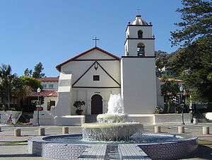
Ventura, officially the City of San Buenaventura,[10] is the county seat of Ventura County, California, United States. European explorers encountered a Chumash village, referred to as Shisholop, in Ventura while traveling along the Pacific coast.[11][12](p36) The eponymous Mission San Buenaventura was founded nearby in 1782 where it benefitted from the water of the Ventura River. The town grew around the mission compound and incorporated in 1866. The development of nearby oil fields in the 1920s and the age of automobile travel created a major real estate boom during which many designated landmark buildings were constructed. The mission and these buildings are at the center of a downtown that has become a cultural, retail, and residential district and visitor destination.
Ventura lies along U.S. Route 101 between Los Angeles and Santa Barbara, which was one of the original U.S. Routes. The highway is now known as the Ventura Freeway, but the original route through the town along Main Street has been designated El Camino Real, the historic pathway connecting the California missions. During the post–World War II economic expansion, the community grew easterly, building detached single family homes over the rich agricultural land created by the Santa Clara River. The population was 106,433 at the 2010 census, up from 100,916 at the 2000 census. Ventura is part of the Los Angeles metropolitan area.
History


Prehistory and indigenous peoples
Archaeological discoveries in the area suggest that humans have populated the region for at least 10,000-12,000 years.[13] Archaeological research demonstrates that the Chumash people have deep roots in central and southern coastal regions of California, and has revealed artifacts from their culture.[12](p11) Shisholop Village, designated Historic Point of Interest #18 by the city at the foot of nearby Figueroa Street, was the site of a Chumash village.[11] The Ventura band (Mitskanaka), which was in residence at the time of the arrival of the Spanish, had contact with the Limu band on Santa Cruz Island, who traveled in seagoing Tomols, plank-built boats, bringing shell bead money and chert in trade.[14][15]
Spanish period (1769 - 1822)
In 1769, the Spanish Portola expedition, first recorded European visitors to inland areas of California, came down the Santa Clara River Valley from the previous night's encampment near today's Saticoy and camped near the outlet of the Ventura River on August 14. Fray Juan Crespi, a Franciscan missionary traveling with the expedition, noted that "we saw a regular town, the most populous and best laid-out of all that we had seen on the journey up to the present time."[16] Archaeological records found that the Chumash village they encountered was settled sometime around 1000 A.D.
Junípero Serra, first leader of the Franciscans in California, founded Mission San Buenaventura in 1782 as his ninth and last mission establish as part of Spain's colonization of Alta California.[17] The mission was named for St. Bonaventure, a Thirteenth Century Franciscan saint and a Doctor of the Church. San Miguel Chapel was the first outpost and center of operations while the first Mission San Buenaventura was being constructed. The first mission burned in 1801 and a replacement building of brick and stone was completed in 1809. The bell tower and facade of the new mission was destroyed by an 1812 earthquake.[18][19] The Mission was rebuilt and functions as a parish church. Historic tours of downtown include the mission compound.
Mexican period (1822 - 1848)
On July 6, 1841, Governor Juan Bautista Alvarado granted Rancho San Miguel to Felipe Lorenzana and Raymundo Olivas,[20] whose Olivas Adobe on the banks of the Santa Clara River was the most magnificent hacienda south of Monterey.
Early agricultural development (1849 - 1919)
After the American Civil War, settlers came to the area, buying land from the Mexicans, or simply as squatters. Vast holdings were later acquired by Easterners, including the railroad magnate, Thomas A. Scott. He was impressed by one of the young employees, Thomas R. Bard, who had been in charge of train supplies to Union troops, and Bard was sent west to handle Scott's property. Not easily accessible, Ventura was not a target of immigrants, and remained quiet and rural. For most of the century which followed the incorporation of Ventura in 1866, it remained isolated from the rest of the state.
Ventura Pier was built in 1872 at a cost of $45,000 and was the longest wooden Pier in California. In 1914 a ship severed the pier. It was rebuilt to a length of 1,700 feet (520 m) by 1917. An active wharf for 64 years, it was reinforced with steel pilings after 420 feet (130 m) of the pier was destroyed by a storm in 1995.[21][22][23][24]
Oil and development boom (1920 - 1945)
Bard is often regarded as the Father of Ventura County and his descendants have been prominently identified with the growth of the county. The Union Oil Company was organized with Bard as President in 1890, and has offices in Santa Paula. The large Ventura Oil Field was first drilled in 1919 and at its peak produced 90,000 barrels per day (14,000 m3/d).[25][26] The development of the oil fields in the 1920s, along with the building of better roads to Los Angeles and the affordability of automobiles, enabled a major real estate boom. Contemporary downtown Ventura is defined by extant buildings from this period.[27][28] In this bustling oil boom town Ventura Theatre opened in 1928.[29] During this decade, many other buildings were constructed: the Hobson Brothers Meat Packing Company (1923),[30] the First National Bank of Ventura (1926) (commonly called the Earl Stanley Gardner),[31] the Ventura Hotel (1926), the Elks Lodge - B. P. 0. E. #1430 (1928),[32] the Mission Theater (1928), the Hotel Washington (1928), the Swift & Company Building (1928), and the Masonic Temple (1929).[27]
Located between the Ventura River and the Santa Clara River, the soil is so fertile that town boosters claimed that citrus grew better here than anywhere else in the state. The citrus farmers formed Sunkist Growers, Incorporated, the world's largest organization of citrus production. On March 12, 1928, the St. Francis Dam, 54 mi (87 km) inland, failed catastrophically, taking over 600 lives. The resulting flood reached Montalvo about 5:30 a.m., almost two miles (3 km) wide and traveling at a speed of 5 mph (8.0 km/h) per hour.
Postwar years and the 1950s boom (1946 - present)

From the south, travel by auto was slow and hazardous, until the completion of a four-lane freeway (US Highway 101) over the Conejo Grade in 1959. This route, now further widened and improved by 1969, is known as the Ventura Freeway, which directly links Ventura with the rest of the Los Angeles metropolitan area. Another route, US Highway 101 ALT (now the Pacific Coast Highway) traveled along the coast from Santa Monica via Oxnard, but was not heavily used.
From the north, entrance was by way of a single road along the beach and stagecoach passengers either had to wait until low tide when the horses could cross on the exposed wet sand, or go up the Ventura River Valley and then cross over the mountains to Santa Barbara via Casitas Pass, a long and difficult trip. In 1913, the Rincon Sea Level Road and the Ventura River Bridge opened; motoring tourists no longer had to fear coming through here.[33]
Inland, Ventura was hemmed in by the mountainous country and deep canyons of the Los Padres National Forest. This route became passable with the completion of the Maricopa Highway (U.S. 399, now state highway 33) in the 1930s, connecting Ventura and Ojai with the San Joaquin Valley.
Ventura continued to grow steadily. In 1920 there were 4,156 people. In 1930 the population had increased to 11,603, by 1950 the population reached 16,643, by 1970 the population was 57,964, and in 1980 the population had increased to 73,774. In the last three decades it has increased to approximately 107,000. To minimize outward growth onto the agricultural land that surrounds the existing community, the city is pursuing a strategy of "in-fill first" with the 2005 General Plan which means growth will focus inward to certain "Districts, Corridors, and Neighborhood Centers" that will become more intensely populated.[34]
Geography

Ventura is located northwest of Los Angeles on the California coast. The western portion of the City stretches north along the Ventura River and is characterized by a narrow valley with steeply sloped areas along both sides. The steep slopes of the Ventura foothills abut the northern portion of the community. Much of the eastern portion is on relatively flat alluvial coastal plain lying along the western edge of the Oxnard Plain. The Santa Clara River forms the city's southerly boundary with the city limits reaching up to the beginning of the Santa Clara River Valley at the historic community of Saticoy.[35]
According to the United States Census Bureau, Ventura has a total area of 32.1 square miles (83 km2), of which 21.7 square miles (56 km2) is land and 10.4 square miles (27 km2) (32.53%) is water.
Climate
Ventura has a Mediterranean climate, typical of most coastal California cities, with the sea breeze off the Pacific Ocean moderating temperatures. It is not uncommon for the city to be affected by Santa Ana winds off the Transverse Ranges on occasion, which increase temperatures dramatically.
| Climate data for Ventura, California | |||||||||||||
|---|---|---|---|---|---|---|---|---|---|---|---|---|---|
| Month | Jan | Feb | Mar | Apr | May | Jun | Jul | Aug | Sep | Oct | Nov | Dec | Year |
| Record high °F (°C) | 88 (31) |
91 (33) |
99 (37) |
100 (38) |
101 (38) |
102 (39) |
103 (39) |
103 (39) |
103 (39) |
103 (39) |
99 (37) |
96 (36) |
103 (39) |
| Average high °F (°C) | 66 (19) |
66 (19) |
65 (18) |
68 (20) |
68 (20) |
70 (21) |
73 (23) |
74 (23) |
74 (23) |
73 (23) |
70 (21) |
66 (19) |
69.4 (20.8) |
| Daily mean °F (°C) | 55.5 (13.1) |
56.5 (13.6) |
56.5 (13.6) |
59 (15) |
60.5 (15.8) |
63 (17) |
66 (19) |
67 (19) |
66.5 (19.2) |
64 (18) |
59.5 (15.3) |
55.5 (13.1) |
60.79 (15.98) |
| Average low °F (°C) | 45 (7) |
47 (8) |
48 (9) |
50 (10) |
53 (12) |
56 (13) |
59 (15) |
60 (16) |
59 (15) |
55 (13) |
49 (9) |
45 (7) |
52.2 (11.2) |
| Record low °F (°C) | 29 (−2) |
28 (−2) |
31 (−1) |
35 (2) |
39 (4) |
42 (6) |
44 (7) |
46 (8) |
42 (6) |
37 (3) |
33 (1) |
29 (−2) |
28 (−2) |
| Average rainfall inches (mm) | 3.41 (86.6) |
3.90 (99.1) |
3.04 (77.2) |
0.72 (18.3) |
0.21 (5.3) |
0.05 (1.3) |
0.02 (0.5) |
0.07 (1.8) |
0.36 (9.1) |
0.36 (9.1) |
1.37 (34.8) |
2.11 (53.6) |
15.62 (396.7) |
| Source: http://www.weather.com/outlook/travel/businesstraveler/wxclimatology/monthly/graph/USCA1193 | |||||||||||||
Demographics
| Historical population | |||
|---|---|---|---|
| Census | Pop. | %± | |
| 1880 | 1,370 | — | |
| 1890 | 2,320 | 69.3% | |
| 1900 | 2,470 | 6.5% | |
| 1910 | 2,901 | 17.4% | |
| 1920 | 4,156 | 43.3% | |
| 1930 | 11,603 | 179.2% | |
| 1940 | 13,264 | 14.3% | |
| 1950 | 16,534 | 24.7% | |
| 1960 | 29,114 | 76.1% | |
| 1970 | 57,964 | 99.1% | |
| 1980 | 73,774 | 27.3% | |
| 1990 | 92,575 | 25.5% | |
| 2000 | 100,916 | 9.0% | |
| 2010 | 106,433 | 5.5% | |
| Est. 2015 | 109,708 | [36] | 3.1% |

2010
The 2010 United States Census[38] reported that Ventura had a population of 106,433. The population density was 3,316.2 people per square mile (1,280.4/km²). The racial makeup of Ventura was 76.6% White, 1.6% African American, 1.2% Native American, 3.4% Asian (0.9% Filipino, 0.6% Chinese, 0.4% Indian, 0.4% Korean, 0.4% Japanese, 0.3% Vietnamese, 0.5% Other), 0.2% Pacific Islander, 5.2% from two or more races. Hispanic or Latino of any race were 31.8% of the population.
The Census reported that 103,940 people (97.7% of the population) lived in households, 755 (0.7%) lived in non-institutionalized group quarters, and 1,738 (1.6%) were institutionalized.
There were 40,438 households, out of which 13,014 (32.2%) had children under the age of 18 living in them, 18,907 (46.8%) were opposite-sex married couples living together, 4,936 (12.2%) had a female householder with no husband present, 2,153 (5.3%) had a male householder with no wife present. There were 2,621 (6.5%) unmarried opposite-sex partnerships, and 371 (0.9%) same-sex married couples or partnerships. 10,959 households (27.1%) were made up of individuals and 4,271 (10.6%) had someone living alone who was 65 years of age or older. The average household size was 2.57. There were 25,996 families (64.3% of all households); the average family size was 3.14.
The population was spread out with 23,918 people (22.5%) under the age of 18, 9,581 people (9.0%) aged 18 to 24, 28,814 people (27.1%) aged 25 to 44, 29,957 people (28.1%) aged 45 to 64, and 14,163 people (13.3%) who were 65 years of age or older. The median age was 39.0 years. For every 100 females there were 97.7 males. For every 100 females age 18 and over, there were 95.6 males.
There were 42,827 housing units at an average density of 1,334.4 per square mile (515.2/km²), of which 22,600 (55.9%) were owner-occupied, and 17,838 (44.1%) were occupied by renters. The homeowner vacancy rate was 1.3%; the rental vacancy rate was 5.5%. 59,330 people (55.7% of the population) lived in owner-occupied housing units and 44,610 people (41.9%) lived in rental housing units.
2000
As of the census[39] of 2000, there were 100,916 people, 38,524 households, and 25,233 families residing in the city. The population density was 4,790.6 inhabitants per square mile (1,849.3/km²). There were 39,803 housing units at an average density of 1,889.5 per square mile (729.4/km²). The racial makeup of the city was 78.8% White, 1.4% African American, 1.2% Native American, 3.0% Asian, 0.2% Pacific Islander, 11.1% from other races, and 4.3% from two or more races. Hispanic or Latino of any race were 30.4% of the population.

There were 38,524 households out of which 32.1% had children under the age of 18 living with them, 49.2% were married couples living together, 11.7% had a female householder with no husband present, and 34.5% were non-families. 26.5% of all households were made up of individuals and 9.7% had someone living alone who was 65 years of age or older. The average household size was 2.56 and the average family size was 3.12.
In the city the population was spread out with 25.0% under the age of 18, 7.8% from 18 to 24, 31.5% from 25 to 44, 22.8% from 45 to 64, and 12.8% who were 65 years of age or older. The median age was 37 years. For every 100 females there were 96.9 males. For every 100 females age 18 and over, there were 93.8 males.
The median income for a household in the city was $52,297, and the median income for a family was $60,466. Males had a median income of $43,828 versus $31,793 for females. The per capita income for the city was $25,065. About 6.4% of families and 9.0% of the population were below the poverty line, including 12.2% of those under age 18 and 5.3% of those age 65 or over.
Economy
Patagonia is based in Ventura.[40] The headquarters of outdoor clothing manufacturer is located downtown. The eco-designer Stewart+Brown has their factory just a few blocks from the ocean. Diaper bag manufacturer Petunia Pickle Bottom is headquartered near downtown Ventura. Ventura is a course in Tony Hawk's Pro Skater 2. It was called 'Skatestreet Ventura'.
Top employers
According to the State of California's Employment Development Department the America's Labor Market Information System (ALMIS) Employer Database, 2016 1st Edition, indicated that the major employers in the city of Ventura, CA are California State University, Coleman Welding, Community Memorial Health System and Community Memorial Hospital.
According to the City's 2011 Comprehensive Annual Financial Report,[41] the top employers in the city are:
| # | Employer | # of Employees |
|---|---|---|
| 1 | County of Ventura | 7,991 |
| 2 | Ventura County Health Care Agency | 2,493 |
| 3 | Ventura Unified School District | 1,916 |
| 4 | Ventura College | 1,913 |
| 5 | Community Memorial Hospital | 1,881 |
| 6 | Argon ST | 990 |
| 7 | City of San Buenaventura | 595 |
| 8 | Employer's Depot | 550 |
| 9 | MediTech Health Services | 400 |
| 10 | Judicial Council of California | 370 |
Incubator
In 2009 the City of Ventura created Ventura Ventures Technology Center,[42] a business incubator with a high-tech focus. Ventura Ventures Technology Center was created as an economic engine to develop jobs and companies locally, as well as attract entrepreneurs to the area.
Technology
Ventura IT is the oldest provider of information technology and web design services to Ventura County businesses and non-profit organizations.[43]
Arts and Culture
The Ventura County Fairgrounds is the home of the annual Ventura County Fair, and over the years has hosted such acts as Jimi Hendrix, The Grateful Dead, Smokey Robinson, and All American Rejects, as well as the Vans Warped Tour. The Derby Club (offering Horse Racing Live via Satellite), and full service bars and restaurants. The Train Station for Amtrak's Pacific Surfliner route is adjacent to the fairgrounds.
The Ventura Film Festival puts on a yearly red carpet gala event and has hosted some of film's top celebrities including the 50th Anniversary of the famous film "West Side Story (film)" and given awards to the Academy Award winning cast of "West Side Story" and a lifetime achievement award to Academy Award winner George Chakiris and Academy Award Nominee Russ Tamblyn. The films Swordfish, Little Miss Sunshine, Chinatown, Erin Brockovich, The Aviator, and The Rock were partly filmed in Ventura, and most of the 2011 release Bellflower was shot in Ventura.[44]
Downtown's Majestic Ventura Theater is an early 20th-century landmark. A venue for concerts, it has seen performances from legendary artists such as The Doors, Pearl Jam, Van Halen, X, Ray Charles, Red Hot Chili Peppers, Social Distortion, Bad Religion, Fugazi, Incubus, Tom Petty, They Might Be Giants, and Johnny Cash, as well as some of the city's most successful homegrown artists like Big Bad Voodoo Daddy and Army of Freshmen.
Sports
Ventura is famed for the quality and frequency of the surfing conditions at spots such as Surfer's Point near the Ventura County Fairgrounds.[45] The Ventura County Fairgrounds is the home to the Ventura Raceway, "The best little dirt track in America",[46] Ventura is the home to the soccer clubs Ventura County Football Club[47] and Ventura County Fusion, of the USL Premier Development League.
Education
Ventura has four college campuses, Ventura College of Law, Southern California Institute of Law, Santa Barbara Business College and Ventura College. Ventura College is a community college, part of the Ventura County Community College District.[48] The Ventura College of Law is a non-profit law school founded in 1969. Ventura Institute of Technology (aka Ventura Institute) provides non-accredited computer and technology related classes in the city of Ventura.[49] The Brooks Institute of Photography shut down in 2016 after many years in the community.
Public school students from kindergarten through 12th grade attend schools in the Ventura Unified School District. The district has five high schools: Ventura High in the midtown area, Buena High in east Ventura, Foothill Technology High School, Pacific High School[50] and El Camino High School, an independent study program located on the Ventura College campus. Private schools include St. Bonaventure High School, a Catholic school, Ventura County Christian School, an evangelical Christian school,[51] and Holy Cross School, Sacred Heart, and Our Lady of the Assumption, Roman Catholic schools for grades Pre-K-8.
Infrastructure
Libraries
Public Libraries: Ventura County Library - There are three branches in the City of Ventura: E.P. Foster Library[52] on Main Street, Avenue Library[53] on the Avenue, and Saticoy Library[54] in the unincorporated area of Saticoy. H.P. Wright Library[55] was closed on November 30, 2009 due to lack of funding. All books from the H.P. Wright Library were integrated into the E.P. Foster Library in March 2010.
Academic Library: Ventura College
Other: Ventura County Law Library
Transportation
The major road through Ventura is the Ventura Freeway (U.S. Route 101), connecting the California Central Coast and San Francisco to the north, and Los Angeles to the south. State Route 33, the Ojai Freeway, heads north to Ojai. State Route 126 and State Route 118 head east to Santa Clarita and Simi Valley, respectively.
The East Ventura Station, in the historic Montalvo neighborhood, serves as the western terminus of the Ventura County Line of the Metrolink commuter rail system, which extends to Los Angeles' Union Station. The Ventura Amtrak Station is served by Amtrak's Pacific Surfliner from San Luis Obispo to San Diego.
Local bus service is provided by Gold Coast Transit. Commuter and intercity bus services are provided by VISTA and by MTD to Santa Barbara.
The Downtown - Harbor Trolley began its free service on July 3, 2013. The Trolley makes loops from Downtown to Ventura Harbor.[56]
Water and sewer utilities
Ventura provides water and sewer utilities services to its residents.[57] The Montalvo Community Services District looked at the cost of a new treatment plant in 2014 and considered having the city take over their service area and dissolve the district. The Montalvo Municipal Improvement District had been formed 60 years prior to bring sewer service to what was then a remote unincorporated area southeast of Ventura. The city of Ventura annexed the last unincorporated portions of Montalvo in 2012[58] and had already provided water to the community before the annexation.[59]
In popular culture
Film
The movies Swordfish and Little Miss Sunshine were partially filmed in Ventura, as were parts of the movie Erin Brockovich.[60]
The comedy film, The Bet, was filmed entirely in the city of Ventura and was written by Ventura residents, Chris Jay and Aaron Goldberg, both members of the band Army of Freshmen.
Books
Ventura was fictionalized as 'Madison City' by long-time resident Erle Stanley Gardner in his D.A. Series of crime novels featuring Doug Selby, crusading District Attorney of a rural California county.
Points of interest
Downtown Ventura
Downtown Ventura is home to the Mission San Buenaventura, museums, galleries, dining, and shopping. Primary areas of activity include California Street and Main Street between Ventura Avenue and Fir Street. Located in downtown is the historic Ortega Adobe, once home to the Ortega family, now famous for their chili products. Numerous thrift stores contrast with high-end shops and restaurants. Downtown Ventura is home to Ventura's ornate city hall with its statue of Junipero Serra.[61] Downtown now features numerous restaurants, wine bars and the internationally acclaimed Rubicon Theatre Company.
Ventura Visitors Center
The 4,300-square-foot (400 m2) Ventura Visitors Center, at 101 South California Street, has exhibits on the Heritage Valley, Channel Islands National park, the local arts scene, and maps and brochures about the area.

Two Trees
One of the most recognizable landmarks in Ventura is "Two Trees" which are two prominent lone trees on a hilltop, visible from most of Ventura. Access to the hill is private property. Signs at the bottom of the trails and at the trees themselves warn trespassers.[62]
Plaza Park
In Plaza Park (Chestnut and Santa Clara Streets, downtown) stands one of the nation's largest Moreton Bay Fig Trees. Across the street, the main post office has murals on interior walls commissioned by the Section of Painting and Sculpture of the U.S. Treasury Department as New Deal art.[63]
Ventura Harbor
The Ventura Harbor has fishing boats, seafood restaurants and a retail center, the Ventura Harbor Village. The Channel Islands National Park Headquarters is also located in the harbor, and boats to the Channel Islands depart from there daily.
The Westside of Ventura is a large Subdivision of neighborhoods, along Ventura Avenue.
Pierpont Bay
Pierpont Bay (Pierpont) is a residential neighborhood in the one-mile stretch between the Ventura Harbor and San Buenaventura State Beach. Reclaimed marshland was subdivided in 1925 and houses were built in fits of development interrupted by years of economic depression, war, and coastal floods (in 1937 and 1962). Long a hodge-podge of rental dwellings, weekend cottages and vacant lots, it was transformed by successive California real estate booms into a fashionable but eclectic mix of newer large homes and older modest beach cottages, now mostly owner-occupied. Piecemeal development, not overly burdened by planning efforts or regulatory attentions, left Pierpont with widely varying architectural styles, a spotty retail district Seaward Avenue, newer residents' demands for increased municipal maintenance, and continuing disputes about the proper regulation of the neighborhood's public beaches. Recently plans have been announced for high-density development on some streets, and state authorities have begun to more actively manage beaches that were mostly self-regulated for eighty years.

Olivas Adobe
The Olivas Adobe, one of the early "California Rancho" styled homes, is operated today as a museum and performing arts venue. Located adjacent to the Olivas Park Golf Course, the home is one of the most visited historic sites on the central Pacific Coast. Living history reenactments, demonstrations of Rancho life, and wonderful ghost stories abound. A summer music series of performances held in the old home's courtyard feature an eclectic assortment of artists from blues to jazz to country.
Erle Stanley Gardner
The famous character, lawyer "Perry Mason", created by Erle Stanley Gardner, first as novels and then later as a television series in the late 1950s and early 60's, followed by several "made-for-TV" movies in the 1980s, had his fictional law practice and did much of his early writing in Downtown Ventura. The building where his law offices were housed, at California and Main Streets, bears his name on a state historical marker.
Notable locations

|
|
Parks

|
|
Sister cities
-
 Loreto, Baja California Sur (Mexico)[67]
See also
References
- ↑ "California Cities by Incorporation Date" (Word). California Association of Local Agency Formation Commissions. Retrieved August 25, 2014.
- ↑ "City Council". City of Ventura. Retrieved December 8, 2015.
- ↑ "City Manager Mark Watkins". City of Ventura. Retrieved January 11, 2015.
- 1 2 "Statewide Database". UC Regents. Retrieved November 23, 2014.
- ↑ "Communities of Interest - City". California Citizens Redistricting Commission. Retrieved September 27, 2014.
- ↑ "2010 Census U.S. Gazetteer Files – Places – California". United States Census Bureau.
- ↑ "Ventura". Geographic Names Information System. United States Geological Survey. Retrieved December 3, 2014.
- ↑ "E-1 Current Population Estimates for Cities, Counties, and the State: January 1, 2013 and 2014". State of California, Department of Finance. May 2014. Retrieved February 8, 2015.
- ↑ "ZIP Code(tm) Lookup". United States Postal Service. Retrieved December 3, 2014.
- ↑ Erwin G. Gudde, California Place Names: The Origin and Etymology of Current Geographical Names, 4th ed., rev. and enlarged by William Bright (University of California Press, 1998), p. 410.
- 1 2 Landmark #18: Shisholop Village Site accessed 7 October 2013 from link on City Map with Historic Landmarks
- 1 2 McCall, Lynne; Perry, Rosalind (2002). California's Chumash Indians : a project of the Santa Barbara Museum of Natural History Education Center (Revised edition ed.). San Luis Obispo, Calif: EZ Nature Books. ISBN 0936784156.
- ↑ Clerici, Kevin (July 17, 2007). "Artifacts are found at site". Ventura County Star. Archived from the original on December 3, 2013.
- ↑ Anderson, John (1999). "The Chumash Indians Who Live in Ventura County California: The Ventura Chumash". Retrieved May 7, 2013.
- ↑ "Santa Cruz Island - Channel Islands National Park". National Park Service. Retrieved April 26, 2013.
- ↑ Bolton, Herbert E. (1927). Fray Juan Crespi: Missionary Explorer on the Pacific Coast, 1769-1774. HathiTrust Digital Library. pp. 159–160. Retrieved April 2014. Check date values in:
|access-date=(help) - ↑ Murphy, Arnold L. (ed.) (1979). A Comprehensive Story of Ventura County, California. Oxnard, CA: M & N Printing. p. 8.
- ↑ Hogle, Gene NAC Green Book of Pacific Coast Touring (1931) National Automobile Club p.25
- ↑ Stolz, Kit (January 5, 2014). "Ventura earthquake fault more dangerous than previously thought, geologists say". Ventura County Star. Retrieved 5 January 2016.
- ↑ "Spanish and Mexican Land Grants". Ventura County Genealogical Society. Archived from the original on March 18, 2007. Retrieved March 17, 2007.
- ↑ Scheibe, John (January 24, 2014). "Ventura Pier closed after piling gives way". Ventura County Star. Retrieved 2015-10-26.
- ↑ Young, Don (2009). Southern California Adventure Guide. Hunter Publishing, Inc.
- ↑ Gorman, Anna (February 8, 1999). "Landmark Pier Readies for Latest Renovation Project". Los Angeles Times. Retrieved 6 July 2016.
- ↑ Langlois, Roseann (July 19, 1999). "Pier Renovation Begins This Week". Los Angeles Times. Retrieved 6 July 2016.
- ↑ Stolz, Kit (April 16, 2009). "Tar on your foot". Ventura County Reporter. Retrieved 7 April 2016.
- ↑ Martinez, Arlene (April 6, 2016). "Ventura Oil Field celebrates 100 years". Ventura County Star. Retrieved 7 April 2016.
- 1 2 "The Swift & Company Building" (PDF). Historic Landmark Designation Application. City of Ventura. March 24, 2014. Retrieved 7 April 2016.
- ↑ "Historic Landmark #108" (PDF). City of Ventura. Retrieved 7 April 2016.
- ↑ Hamilton, Denise (June 09, 1988) "A New Life Awaits Ventura Theater : Restaurateur Has Big Plans to Book Jazz, Country, Salsa Acts at Ornate Ex-Movie House" Los Angeles Times
- ↑ City of Ventura. Historic Landmark #23
- ↑ City of Ventura. Historic Landmark #37
- ↑ City of Ventura. Historic Landmark #99
- ↑ Gyllstrom, Paul. "Rincon Sea-Level Road Soon Completed" Motor Age, Volume XXII, 17 October 1912, p. 25
- ↑ City Of Ventura "Ventura's General Plan" Planning Webpage Accessed April 28, 2014
- ↑ Rincon Consultants, Inc. (June 2014) "Olivas Park Drive Extension Project Final Environmental Impact Report SCH # 1995081004" City of Ventura
- ↑ "Annual Estimates of the Resident Population for Incorporated Places: April 1, 2010 to July 1, 2015". Retrieved July 2, 2016.
- ↑ "Census of Population and Housing". Census.gov. Retrieved June 4, 2015.
- ↑ "2010 Census Interactive Population Search: CA - San Buenaventura (Ventura) city". U.S. Census Bureau. Retrieved July 12, 2014.
- ↑ "American FactFinder". United States Census Bureau. Retrieved January 31, 2008.
- ↑ "Patagonia Job Listing for Ventura, CA, Reno, NV, and worldwide". Patagonia.com. Retrieved May 12, 2014.
- ↑ "2011 Comprehensive Annual Financial Report" (PDF). City of San Buenaventura CAFR.
- ↑ "v2tc.com". v2tc.com. Retrieved May 12, 2014.
- ↑ "Ventura IT". vcstar.com. Retrieved November 18, 2016.
- ↑ Johnson, Brett. "Can-do movie crew: Ventura County amateurs' 'no budget' film 'Bellflower' earns slot at Sundance Film Festival". Ventura County Star. January 15, 2011. Retrieved May 7, 2013.
- ↑ Thompson, Doug (February 25, 2016). "Stand-up paddleboarders hit Ventura's big waves". Ventura County Star. Retrieved 23 March 2016.
- ↑ "Ventura Raceway Channel". Ustream.tv. Retrieved May 12, 2014.
- ↑ "Ventura County FC". Ventura County Football Club. Retrieved 1 December 2016.
- ↑ "Ventura County Community College District". vcccd.edu. Retrieved May 12, 2014.
- ↑ "Ventura Institute of Technology aka Ventura Institute". ventura.institute. Retrieved November 18, 2016.
- ↑ Pacific High School
- ↑ Ventura County Christian School
- ↑ "E. P. Foster Library | Ventura County Library". Vencolibrary.org. Retrieved May 12, 2014.
- ↑ "Avenue Library | Ventura County Library". Vencolibrary.org. Retrieved May 12, 2014.
- ↑ "Saticoy Library — Serving Saticoy, Somis and Ventura's East End | Ventura County Library". Vencolibrary.org. Retrieved May 12, 2014.
- ↑ http://www.vencolibrary.org/locations/wright
- ↑ "venturatrolley.com". venturatrolley.com. Retrieved May 12, 2014.
- ↑ Heitmann, Cheryl (November 19, 2014) "Ventura mayor defines full-service city" Ventura County Star
- ↑ Biasotti, Tony (October 19, 2011). "Agency approves Parklands annexation in east Ventura". Ventura County Star.
- ↑ Biasotti, Tony (November 14, 2014) "'End of an era' in Montalvo, as sewer district prepares to hand off services" Ventura County Star
- ↑ Clerici, Kevin (October 2, 2010) "Ventura launches campaign to promote film, television" Ventura County Star
- ↑ Department of Geography, University of California, Berkeley "Father Junipero Serra" Sculpture – Ventura CA"Living New Deal Accessed March 3, 2014
- ↑ Martinez, Arlene "Two Trees: Look but don't touch (or hike near)" Ventura County Star (November 20, 2013) Retrieved January 25, 2014
- ↑ Department of Geography, University of California, Berkeley "Ventura Post Office "Agriculture and Industries of Ventura" – Ventura CA" Living New Deal Accessed March 3, 2014
- ↑ "Mission Park". Ventura.com. Retrieved May 12, 2014.
- ↑ "Plaza Park". Ventura.com. Retrieved May 12, 2014.
- ↑ Kallas, Anne (May 5, 2016). "Fitness area opens in Ventura's Westpark Community Center". Ventura County Star. Retrieved 5 May 2016.
- ↑ Staff (March 30, 2015). "Ventura, Loreto discuss new sister city program during binational visit". Ventura County Star. Retrieved 1 March 2016.
External links
| Wikimedia Commons has media related to Ventura, California. |
| Wikivoyage has a travel guide for Ventura. |
- Official website
- Ventura, California on City Data
- Movies and televisions shows filmed in Ventura
- Ventura Visitor's and Convention Bureau
- Ventura Port District
- Ventura Chamber of Commerce

Municipalities and communities of Ventura County, California, United States | ||
|---|---|---|
| Cities | 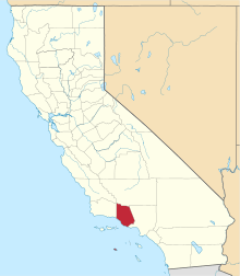 | |
| CDPs | ||
| Unincorporated communities | ||
| Footnotes | ‡This populated place also has portions in an adjacent county or counties | |
| Counties |  | |
|---|---|---|
| Cities and towns 100k-250k | ||
| Cities and towns 25k-100k | ||
| Cities and towns 10k-25k | ||
| Sub-regions | ||
Counties in italics sometimes included in the definition of the Central Coast | ||
Sacramento (capital) | ||
| Topics |  | |
| Regions |
| |
| Metro regions | ||
| Counties |
| |
| Most populous cities | ||
| |
^* Mayor selected from city council
|