Simi Valley, California
| Simi Valley, California | |||
|---|---|---|---|
| General law city[1] | |||
|
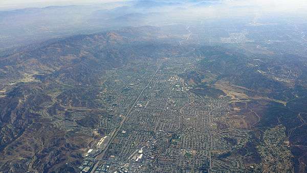
Aerial view of Simi Valley in 2014 | |||
| |||
 Location in Ventura County and the state of California | |||
 Simi Valley, California Location in the United States | |||
| Coordinates: 34°16′16″N 118°44′22″W / 34.27111°N 118.73944°WCoordinates: 34°16′16″N 118°44′22″W / 34.27111°N 118.73944°W | |||
| Country | United States | ||
| State | California | ||
| County | Ventura | ||
| Incorporated | October 10, 1969[2] | ||
| Government | |||
| • Type | Council-Manager[3] | ||
| • Body |
City council:[4] Mayor Bob Huber Glen T. Becerra Steven T. Sojka Mike Judge Keith Mashburn | ||
| • City manager | Eric Levitt[5] | ||
| Area[6] | |||
| • Total | 42.247 sq mi (109.418 km2) | ||
| • Land | 41.480 sq mi (107.433 km2) | ||
| • Water | 0.767 sq mi (1.986 km2) 1.81% | ||
| Elevation[7] | 768 ft (234 m) | ||
| Population (April 1, 2010)[8] | |||
| • Total | 124,237 | ||
| • Estimate (2014)[9] | 126,871 | ||
| • Rank |
3rd in Ventura County 46th in California | ||
| • Density | 2,900/sq mi (1,100/km2) | ||
| Time zone | Pacific (UTC−8) | ||
| • Summer (DST) | PDT (UTC−7) | ||
| ZIP codes | 93062–93065, 93093–93094, 93099 | ||
| Area code | 805 | ||
| FIPS code | 06-72016 | ||
| GNIS feature IDs | 1661450, 2411904 | ||
| Website |
www | ||

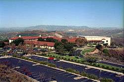
The city of Simi Valley (from the Chumash word, Shimiyi),[10][11][12] in the eponymous valley, is situated in the southeast corner of Ventura County, California, United States. 30 miles (48 km) from Downtown Los Angeles, Simi Valley is part of the Greater Los Angeles Area. The city is adjacent to Thousand Oaks, Moorpark, and the Los Angeles neighborhood of Chatsworth. The city's 2014 population has been estimated at 126,871,[9] up from 111,351 in 2000. The city of Simi Valley is surrounded by the Santa Susana Mountain range and the Simi Hills, west of the San Fernando Valley, and northeast of the Conejo Valley. It is largely a commuter bedroom community feeding the larger cities in Ventura County to the west and the Los Angeles area and the San Fernando Valley to the east.
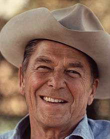
The Ronald Reagan Presidential Library, where the former president was buried following his death in 2004, is in Simi Valley. Simi Valley has been ranked twice as the 18th most Conservative city in the United States; once by The Bay Area Center For Voting Research[13] and also by GovPro.com.[14] The Reagan Library has hosted Republican primary debates, last in 2012,[15] and the first primary debates in 2016.[16] A study done by the University of Vermont ranked Simi Valley as the fifth-happiest city in the United States.[17] According to crime statistics by the FBI in 2013, Simi Valley is the seventh-safest city in the U.S. with a population of 100,000 or more.[18][19] The U.S. Census Bureau of 2012 reported a median household income of $87,894, which is higher than the California median of $70,231 and the national average of $62,527.[20][21]
History
Pre-colonial period

Simi Valley was once inhabited by the Chumash people, who also settled much of the region from the Salinas Valley to the Santa Monica Mountains, with their presence dating back 10,000-12,000 years.[23][24][25] Around 5,000 years ago these tribes began processing acorns, and harvesting local marshland plants. Roughly 2,000 years later, as hunting and fishing techniques improved, the population increased significantly.[24] Shortly after this sharp increase a precious stone money system arose, increasing the viability of the region by offsetting fluctuations in available resources relating to climate changes.[26] The native people who inhabited Simi Valley spoke an interior dialect of the Chumash language, called Ventureño.
Simi Valley's name derived from the Chumash word Shimiyi, which refers to the stringy, thread-like clouds that typify the region.[27][28][29] The name could have derived from strands of mist from coastal fog that move into the Oxnard Plain and wind their way up the Calleguas Creek and the Arroyo Las Posas into Simi Valley.[30] The origin of the name was preserved because of the work of the anthropologist John P. Harrington, whose brother, Robert E. Harrington lived in Simi Valley. Robert Harrington later explained the name: "The word Simiji in Indian meant the little white wind clouds so often seen when the wind blows up here and Indians living on the coast, would never venture up here when those wind clouds were in the sky. The word Simiji was constructed by whites to the word Simi. There are other explanations about the name Simi, but this one was given to me by my brother who worked over 40 years for the Smithsonian Institution and it seems most plausible to me".[31][32]
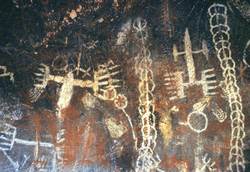
Three Chumash settlements existed in Simi Valley during the Mission period in the late 18th and early 19th century: Shimiyi, Ta’apu (present-day Tapo Canyon), and Kimishax or Quimisac (Happy Camp Canyon west of Moorpark College).[33][34][35] There are many Chumash cave paintings in the area containing pictographs, including the Burro Flats Painted Cave in the Burro Flats area of the Simi Hills, located between the Simi Valley, and West Hills and Bell Canyon. The cave is located on private land owned by Boeing, formerly operated by Rocketdyne for testing rocket engines and nuclear research. Other areas containing Chumash Native American pictographs in the Simi Hills are for instance by Lake Manor and Chatsworth.[36]
Under Spain and Mexico
The first Europeans to visit Simi Valley were members of the Spanish Portolà expedition (1769-1770), the first European land entry and exploration of the present-day state of California. The expedition traversed the valley on January 13–14, 1770, traveling from Conejo Valley to San Fernando Valley. They camped near a native village in the valley on the 14th.[37]
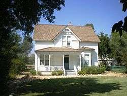
Rancho Simi, also known as Rancho San José de Nuestra Senora de Altagracia y Simi, was a 113,009-acre (457 km2) Spanish land grant in eastern Ventura and western Los Angeles counties given in 1795 to Francisco Javier Pico and his two brothers, Patricio Pico and Miguel Pico by Governor Diego de Borica. Rancho Simi was the earliest Spanish colonial land grant within Ventura and Santa Barbara Counties. The name derives from Shimiji, the name of the Chumash Native American village here before the Spanish.[38] It was one of the largest lands, but later when Mexico became independent from Spain, land was handed out much more freely. The Simi Adobe-Strathearn House, later the home of Robert P. Strathearn, served as the headquarters of the rancho.
José de la Guerra y Noriega, a Captain of the Santa Barbara Presidio, who had begun to acquire large amounts of land in California to raise cattle, purchased Rancho Simi from the Pico family in 1842. A few years after Jose de la Guerra's death in 1858, the rancho was sold to the Philadelphia and California Petroleum Company headed by Pennsylvania Railroad president, Thomas A. Scott. When no great amount of oil was discovered, Scott began to sell the rancho. In 1887, a portion of the rancho was bought by a newly formed company, the Simi Land and Water Company.[39] The small colonial town known as "Santa Susana del Rancho Simi" throve in the late 19th century and had a Spanish-speaking majority, but since then many Anglo-Americans have arrived to settle. Farms, orchards and groves dominated the valley's landscape until the 1970s.
For a brief time, its postal address was known as Simiopolis, though it was soon shortened again to Simi by 1910. The first public school was built in 1890 in the northeast but was torn down in 1926. There was also a great deal of destruction caused by a flood in 1952. The city incorporated as Simi Valley in 1969, when the area had only 10,000 residents. In 1972, Boys Town West was founded in the eastern end of Simi Valley. The youth camp/home facility is based on an older larger one in Boys Town, Nebraska.
Santa Susana Field Laboratory

The 2,848 acres (1,153 ha) Santa Susana Field Laboratory located in the Simi Hills, was used for the development of pioneering nuclear reactors and rocket engines beginning in 1948. The site was operated by Atomics International and Rocketdyne (originally both divisions of the North American Aviation company). The Rocketdyne division developed a variety of liquid rocket engines. Rocket engine tests were frequently heard in Simi Valley. The Atomics International division of North American Aviation designed, built and operated the Sodium Reactor Experiment, the first United States nuclear reactor to supply electricity to a public power system. The last nuclear reactor operated at SSFL in 1980 and the last rocket engine was conducted in 2006. The SSFL has been closed to development and testing. The site is undergoing investigation and removal of the nuclear facilities and cleanup of the soil and groundwater. The Boeing Company, the US DOE, and NASA are responsible for the cleanup.[40][41]
In July 1959, the Sodium Reactor Experiment suffered a serious incident when 13 of the reactor's 43 fuel elements partially melted resulting in the controlled release of radioactive gas to the atmosphere. The reactor was repaired and returned to operation in September, 1960. The incident at the Sodium Reactor Experiment has been a source of controversy in the community. Technical analysis of the incident intended to support a lawsuit against the current landowner (The Boeing Company) asserts the incident caused the much greater release of radioactivity than the accident at Three Mile Island.[42] Boeing's technical response concludes the monitoring conducted at the time of the incident, shows only the allowable amount of radioactive gasses were released, and a Three Mile Island-scale release was not possible.[43] The case was settled, it is reported, with a large payment by Boeing. In September 2009, The U.S. Department of Energy sponsored a public workshop where three nuclear reactor experts shared their independent analysis of the July, 1959 incident.[44]
The Santa Susana Field Laboratory also hosted the Energy Technology Engineering Center. The center performed the design, development and testing of liquid metal reactor components for the United States Department of Energy from 1965 until 1998.[45]
The Santa Susana Field Laboratory includes sites identified as historic by the American Institute of Aeronautics and Astronautics and by the American Nuclear Society. The National Register of Historic Places listed Burro Flats Painted Cave is located within the Santa Susana Field Laboratory, on a portion of the site owned by the U.S. Government. The drawings within the cave have been termed "the best preserved Indian pictograph in Southern California."
Rodney King trial

On November 27, 1991, Judge Stanley Weisberg of the California Court of Appeals selected Simi Valley as the venue for the state case against four officers of the Los Angeles Police Department. The officers (Stacey Koon, Laurence Powell, Timothy Wind, and Theodore Brisenio) were accused of using unnecessary force in a March 3, 1991 beating of an African-American motorist "Rodney" Glen King. The case known as the Rodney King Trials was based on footage recorded on home video by a bystander (George Holliday). The now-famous video was broadcast nationally and globally and caused tremendous response because the beating was believed to be racially motivated. Selecting Simi Valley as a venue for the trial is believed to be motivated by the predominantly white ethnic make-up of the city at the time.[46]
On April 29, 1992, a Ventura County jury acquitted three of the four officers (Koon, Wind, and Brisenio) and did not reach a verdict on one (Powell). Many believed that the unexpected outcome was a result of the racial and social make-up of the jury, which, reflecting the area's population demographic, included ten whites, one Filipino, and one Hispanic. None were Simi Valley residents. Among the jury were three who had been security guards or in military service.[47] The acquittal led to the 1992 Los Angeles riots and mass protest around the country.
Geography


Simi Valley is a city and a valley located in the very southeast corner of Ventura County, bordering the San Fernando Valley in Los Angeles County, and is a part of the Greater Los Angeles Area. The City of Simi Valley basically consists of the eponymous valley itself.[48] City of Simi Valley borders the Santa Susana Mountains to the north, the Simi Hills to the east and south, and is adjacent to Thousand Oaks to the southwest and Moorpark to the west. Simi Valley is connected to the nearby San Fernando Valley by the Santa Susana Pass in the extreme east of Simi Valley. Simi Valley is located at 34°16'16" North, 118°44'22" West (34.271078, −118.739428)[49] with an elevation of 700–1,000 ft (210–300 m) above sea level. The syncline[50] Simi Valley is located in the western part of the region called the Transverse Ranges.[51] The valley is surrounded by the Santa Susana Mountains to the north and Simi Hills to the east and south. While the Santa Susana Mountains separate the valley from the Los Padres National Forest in the north, the Simi Hills separate it from Conejo Valley in the south. In the extreme east is Rocky Peak, one of Santa Susana Mountains' highest peaks, which is a dividing line between Ventura County to the west and Los Angeles County to the east. On the other side of the valley, in the extreme west side of Simi Valley is Mount McCoy, which may be most known for its 12 ft. concrete cross that sits at its peak. The physiographical valley is a structural as well as a topographic depression.[52] The Simi Valley, just as neighboring San Fernando Valley, owes its existence and shape to the faulting and folding of the rocks. It is essentially a structural valley and not wholly the work of erosion.[53] It is drained by the Calleguas Creek and also its principal tributary, Conejo Creek. Both of these originate in the Santa Susana Mountains.
According to the United States Census Bureau, the city has a total area of 42.2 sq mi (109.4 km2), comprising 41.5 sq mi (107.4 km2) of land and 0.77 sq mi (2.0 km2), or 1.81%, of it is water. Simi Valley is located northwest of the Los Angeles neighborhood of Chatsworth and approximately 30 miles from Downtown Los Angeles, 380 mi (612 km) south of San Francisco, 160 mi (257 km) north of San Diego, and 350 mi (563 km) south of Sacramento. Commutes to Los Angeles are usually via the Ronald Reagan Freeway (Highway 118) or the Southern California Metrolink commuter train, which makes several daily trips from Simi Valley. Simi Valley has a mediterranean climate. Temperate variations between day and night tend to be relatively big. The mean annual temperature is 64.1 degrees, while the annual precipitation is 18.39 inches. The precipitation remains less than one inch for seven months - April until October, - while the precipitation exceeds four inches in the two wettest months - January and February. While the mean temperature is at its lowest at 53.6 degrees in December, the mean temperature in July and August exceeds 76 degrees.[54]
Simi Valley has been the victim of several natural disasters, including the flood of 1967, the storm of 1983, the 1988 lightening strike, as well as the 1994 Northridge earthquake and numerous wildfires.[55]

Climate
| Humidity (%) | ||
| High | Low | |
| Jan. | 70 | 50 |
| Apr | 50 | 35 |
| Jul. | 50 | 38 |
| Oct. | 75 | 45 |
| Annual | 61 | 42 |
Simi Valley has a warm and dry climate during summer when mean temperatures tend to be in the 70s. Wildfires do also occur here. The city's climate cools during winter when mean temperatures tend to be in the 50s. Because of its relatively low elevation, the Simi Hills typically experience rainy, mild winters. Snow is rare in the Simi Hills, even in the highest areas. The warmest month of the year is August with an average maximum temperature of 96 °F (36 °C), while the coldest month of the year is December with an average minimum temperature of 38 °F (3 °C). Temperature variations between night and day tend to be relatively big during summer with a difference that can reach 38 °F (21 °C), and moderate during winter with an average difference of 29 °F (16 °C). The annual average precipitation at Simi Valley is 18.3 inches. Winter months tend to be wetter than summer months. The wettest month of the year is February with an average rainfall of 4.6 inches. Simi Valley gets 16 inches of rain per year, while the United States average is 37. Snowfall is 0 inches, while the U.S. average is 25 inches of snow per year. The number of days with any measurable precipitation is 25. On average, there are 277 sunny days in Simi Valley per year. The July high is around 80 °F (27 °C). The January low is 46 °F (8 °C).[56] The record low is 18 degrees Fahrenheit (−8 °C) (recorded in February 1989)[57] and the record high is 116 degrees Fahrenheit (47 °C) (recorded in August 1985).[57] The prevailing wind direction is southwest, and the average wind speed is 7–11 mph (11–18 km/h).
| Climate data for Simi Valley, California | |||||||||||||
|---|---|---|---|---|---|---|---|---|---|---|---|---|---|
| Month | Jan | Feb | Mar | Apr | May | Jun | Jul | Aug | Sep | Oct | Nov | Dec | Year |
| Record high °F (°C) | 93 (34) |
94 (34) |
101 (38) |
105 (41) |
113 (45) |
113 (45) |
115 (46) |
116 (47) |
115 (46) |
110 (43) |
99 (37) |
96 (36) |
116 (47) |
| Average high °F (°C) | 69 (21) |
70 (21) |
73 (23) |
78 (26) |
83 (28) |
88 (31) |
95 (35) |
97 (36) |
93 (34) |
84 (29) |
75 (24) |
68 (20) |
81.1 (27.3) |
| Average low °F (°C) | 39 (4) |
41 (5) |
42 (6) |
45 (7) |
49 (9) |
53 (12) |
57 (14) |
57 (14) |
55 (13) |
49 (9) |
43 (6) |
38 (3) |
47.3 (8.5) |
| Record low °F (°C) | 19 (−7) |
18 (−8) |
26 (−3) |
30 (−1) |
33 (1) |
36 (2) |
42 (6) |
42 (6) |
38 (3) |
27 (−3) |
23 (−5) |
20 (−7) |
18 (−8) |
| Average precipitation inches (mm) | 3.62 (91.9) |
4.81 (122.2) |
2.86 (72.6) |
1.02 (25.9) |
0.31 (7.9) |
0.07 (1.8) |
0.02 (0.5) |
0.05 (1.3) |
0.14 (3.6) |
0.93 (23.6) |
1.34 (34) |
2.76 (70.1) |
17.93 (455.4) |
| Source: The Weather Channel.[58] | |||||||||||||
Natural hazards

An aspect of Simi Valley's location, situated beside the Simi Hills, is that it lies in a high-risk area for the wildfires that sweep through Southern California's mountain ranges every few years. Simi Valley is also at risk for earthquakes. The valley is surrounded by earthquake faults; the closest ones being the Santa Rosa Fault to the Northwest, the Northridge Hills Fault to the Northeast, and the Chatsworth Fault to the South. In 1994, portions of Simi Valley received significant damage from the Northridge earthquake.[59] See Nuclear Accident at SSFL for information on the accident and associated risk(s) to residents.
Wildfires
Southern California has a high fire risk, due to hot weather and high winds. A 2005 fire started on September 28 and burned an estimated 7,000 acres (28 km²). On September 29, the fire was estimated to be 17,000 acres (69 km²). More than 1,000 firefighters worked against the tricky combination of dry brush, low humidity and temperatures in the high 90s along the line that divides Los Angeles and Ventura counties. About 45 evacuees gathered at Canoga Park High School in the San Fernando Valley where the Red Cross had set up cots and provided meals. One firefighter was struck on the head by a 40-pound boulder and was taken to a hospital, officials said. The fire was later brought under control and extinguished, without serious injury. Three homes were lost in outlying areas, but none within the city limits.
Demographics
| Historical population | |||
|---|---|---|---|
| Census | Pop. | %± | |
| 1970 | 59,832 | — | |
| 1980 | 77,500 | 29.5% | |
| 1990 | 100,217 | 29.3% | |
| 2000 | 111,351 | 11.1% | |
| 2010 | 124,237 | 11.6% | |
| Est. 2015 | 126,788 | [60] | 2.1% |
2010
The 2010 United States Census[62] reported that Simi Valley had a population of 124,237. The population density was 2,940.8 people per square mile (1,135.4/km²). The racial makeup of Simi Valley was 93,597 (75.3%) White, 1,739 (1.4%) African American, 761 (0.6%) Native American, 11,555 (9.3%) Asian, 178 (0.1%) Pacific Islander, 10,685 (8.6%) from other races, and 5,722 (4.6%) from two or more races. Hispanic or Latino of any race were 10,938 persons (23.3%); 16.2% of Simi Valley's population are Mexican-American, 1.2% Salvadoran, 0.9% Guatemalan, 0.6% Puerto Rican, 0.6% Peruvian, 0.3% Cuban, 0.3% Argentinean, 0.2% Honduran, 0.2% Nicaraguan, and 0.2% Ecuadorian. Among Asian-Americans, 2.7% of Simi Valley's population were Indian-Americans, 2.2% Filipino, 1.2% Chinese, 1.0% Vietnamese, 0.7% Korean, 0.5% Japanese, 0.2% Thai, 0.1% Pakistani. The majority of Simi Valley's population is made up of Caucasian-Americans; the largest groups of whites were 16.7% German-American, 11.3% English, 8.5% Italian, 3.4% French, 3.1% Polish, 2.3% Norwegian, 2.3% Swedish, 2.1% Scottish and 2% Dutch.[63]
The Census reported that 123,577 people (99.5% of the population) lived in households, 482 (0.4%) lived in non-institutionalized group quarters, and 178 (0.1%) were institutionalized. There were 41,237 households, out of which 16,765 (40.7%) had children under the age of 18 living in them, 24,824 (60.2%) were opposite-sex married couples living together, 4,659 (11.3%) had a female householder with no husband present, 2,214 (5.4%) had a male householder with no wife present. There were 1,975 (4.8%) unmarried opposite-sex partnerships, and 291 (0.7%) same-sex married couples or partnerships. 7,087 households (17.2%) were made up of individuals and 3,013 (7.3%) had someone living alone who was 65 years of age or older. The average household size was 3.00. There were 31,697 families (76.9% of all households); the average family size was 3.33.
The population was spread out with 31,036 people (25.0%) under the age of 18, 11,088 people (8.9%) aged 18 to 24, 33,890 people (27.3%) aged 25 to 44, 35,046 people (28.2%) aged 45 to 64, and 13,177 people (10.6%) who were 65 years of age or older. The median age was 37.8 years. For every 100 females there were 96.6 males. For every 100 females age 18 and over, there were 94.4 males. There were 42,506 housing units at an average density of 1,006.1 per square mile (388.5/km²), of which 30,560 (74.1%) were owner-occupied, and 10,677 (25.9%) were occupied by renters. The homeowner vacancy rate was 1.2%; the rental vacancy rate was 4.6%. 93,181 people (75.0% of the population) lived in owner-occupied housing units and 30,396 people (24.5%) lived in rental housing units.
2000
As of the census[64] of 2000, there are 111,351 people, 36,421 households, and 28,954 families residing in the city. The population density is 1,097.3/km² (2,841.9/mi²). There are 37,272 housing units at an average density of 367.3/km² (951.3/mi²). The racial makeup of the city is 81.33% White, 1.26% Black or African American, 0.70% Native American, 6.33% Asian, 0.14% Pacific Islander, 6.50% from other races, and 3.74% from two or more races. 16.82% of the population are Hispanic or Latino of any race.
There are 36,421 households out of which 42.5% have children under the age of 18 living with them, 63.9% are married couples living together, 10.7% have a female householder with no husband present, and 20.5% are non-families. 14.7% of all households are made up of individuals and 4.9% have someone living alone who is 65 years of age or older. The average household size is 3.04 and the average family size is 3.33.
In the city, the population is spread out with 28.4% under the age of 18, 7.9% from 18 to 24, 32.9% from 25 to 44, 23.1% from 45 to 64, and 7.6% who are 65 years of age or older. The median age is 35 years. For every 100 females there are 97.9 males. For every 100 females age 18 and over, there are 95.6 males.
Income
According to a 2007 estimate, the median income for a household in the city is $88,406, and the median income for a family is $91,658.[65] 10.2% of the population and 7.4% of families are below the poverty line.
Politics
Simi Valley is considered a conservative stronghold politically, along with the neighboring City of Thousand Oaks.[67][68][69] The electorate is often described as solidly Republican.[70] Numerous publications have described Simi Valley among the most conservative cities in the United States;[71] Simi Valley was for instance ranked the 18th most Conservative city in the country in 2005 by GovPro.com.[72] In the 2004 presidential election George W. Bush (R) won nearly 61% of the vote, compared to 44% statewide, while John Kerry (D) won 38% of the vote. In the 2008 presidential election, Barack Obama (D) won 47% of Simi Valley, while John McCain (R) won 52% of the vote.[73] In the 2012 presidential election, Barack Obama won 43% of the vote, while Mitt Romney (R) won 55% of the vote.[74] Republican Bob Huber has been the incumbent mayor since 2010.
The former Republican president and California governor, Ronald Reagan, is buried at the Ronald Reagan Presidential Library on a hilltop by the Thousand Oaks-Simi Valley city limits.[67] The presidential library is frequently visited by Conservative speakers and has been hosting numerous Republican primary debates, including the first debate in the 2008 presidential election, the 2012 presidential election, and the second primary debate for the 2016 presidential election.[75][76][77] Simi Valley is located within the 25th congressional district, represented by Steve Knight. The Simi Valley as well as neighboring Chatsworth are among the most Republican communities in the Greater Los Angeles Area, and the 25th district is among the most conservative in the State of California.[78][79][80] Steve Knight has by the Los Angeles Times and New York Times been described as aligned with the Tea Party movement and has been described as far-right on the political spectrum.[81][82]
Local government
Simi Valley's government uses the "Council-Manager" form of government.[83] This means that the city council is composed of one mayor, elected every two years, and four council members elected for four-year terms. The city council appoints both the city attorney and city manager, who heads the executive branch of the city government. The city manager appoints the various department heads for the city, and acts as the city clerk and city treasurer.
According to the city's most recent Comprehensive Annual Financial Report Fund Financial Statements, the city's various funds had $89.3 million in Revenues, $86.3 million in expenditures, $139.9 million in total assets, $26.1 million in total liabilities, and $158.5 million in investments.[84]
The structure of the management and coordination of city services is:[85]
| Department | Director |
|---|---|
| City Manager | Eric Levitt |
| Administrative Services Director | Ken Al-Imam (Interim) |
| Community Services Director | Sommer Barwick |
| Environmental Services Director | Peter Lyons |
| Public Works Director | Ron Fuchiwaki |
| Police Chief | Mitch McCann |
| City Attorney | Lonnie Eldridge |
State and federal representation
In the state legislature, Simi Valley is in the 27th Senate District, represented by Democrat Henry Stern, and in the 38th Assembly District, represented by Republican Dante Acosta.[86]
In the United States House of Representatives, Simi Valley is split between California's 25th congressional district, represented by Republican Steve Knight, and California's 26th congressional district, represented by Democrat Julia Brownley.[87]
Landmarks
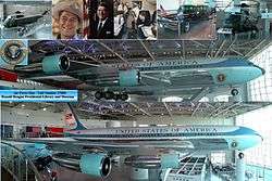
Simi Valley is home to the Ronald Reagan Presidential Library, which has been visited by more than 1 million people since it opened. After a major state funeral in Washington, D.C., President Reagan was buried at the library in June 2004. The library adjoins a hangar in which the Boeing 707 SAM 27000 (Air Force One), which served presidents Nixon through G.W. Bush, is housed and available for tours. In the pavilion are various automobiles used to transport the president, as well as Marine One, the presidential helicopter.
The former Corriganville Movie Ranch and its Fort Apache film set, now Corriganville Regional Park, is the Santa Susana Knolls. Many television series were filmed there during the 1950s, such as Richard Carlson's Mackenzie's Raiders though that program was set at the former Fort Clark near Brackettville in southwestern Texas.[88] Other areas of filming includes Big Sky Ranch, where the Little House on the Prairie was filmed, Poltergeist was filmed on Roxbury Street, and Welcome Danger (1929) and numerous others in Santa Susana.
California Historical Landmarks
.jpg)
Simi Valley is home to two California Historical Landmarks:
NO. 939 Twentieth Century Folk Art Environments (Thematic) - Grandma Prisbrey's Bottle Village - This fantastic assemblage is one of California's remarkable Twentieth Century Folk Art Environments. In 1956, Tressa Prisbrey, then nearly sixty years old, started building a fanciful 'village' of shrines, walkways, sculptures, and buildings from recycled items and discards from the local dump. She worked for 25 years creating one structure after another to house her collections. The Mosaic Walkway is embedded with thousands of treasures—tiles, shells, doorknobs, irons, car ornaments, jewelry, dishware, scissors, guns, toys — everything imaginable that creates a timestamp of 1950s post-consumer waste. Bottle Village originally had more than 13 buildings and 20 sculptures. Although severely damaged during the 1994 Northridge earthquake, it was placed on the National Register of Historic Places in 1996. It is located at 4595 Cochran St, Simi Valley.
NO. 979 Rancho Simi - This is the site of the headquarters of the Spanish Rancho San José de Nuestra Senora de Altagarcia y Simi. The name derives from 'Shimiji,' the name of the Chumash village here before the Spanish. At 113,000 acres (460 km2), Rancho Simi was one of the state's largest land grants. Two prominent Spanish and Mexican family names are connected with the Rancho: Santiago Pico who first received the grant, and José de la Guerra who purchased the Rancho in 1842. Two rooms of original adobe remain, part of the Strathearn home built in The Strathearn Historical Park and Museum, an open-air park that is owned and maintained by the Rancho Simi Recreation and Park District, and is operated jointly with the Simi Valley Historical Society. The house is maintained as a historic house museum with typical period furniture and household displays. In addition to the Simi Adobe-Strathearn House, there are various historic buildings and structures that have been moved from their original site to the park, including the a 1924 children's playhouse with toys, the 1902 St. Rose of Lima Catholic Church, the original Simi Valley Library and two barns with farm tools and equipment. Listed on the National Register of Historic Places: NPS-78000825.[39] Location: Robert P Strathearn Historical Park, 137 Strathearn Place, Simi Valley.
Infrastructure

The Montalvo Cutoff, a railroad line opened by the Southern Pacific Railroad on March 20, 1904, to improve the alignment of its Coast Line, runs east-west through the valley.[89] In 1905, the longest train tunnel in the United States at that time was completed at the east end of Simi Valley. Tunnel #26 still stands today linking Simi Valley and the San Fernando Valley.[90][91][92] The area was originally served by the Santa Susana Depot which was also opened in 1904 as a combination passenger and freight depot built by the Southern Pacific and located on Los Angeles Avenue near Tapo Street. The station remained in use for the following 60 years until changes in the business model for railroads evolved that rendered the depot useless to the railroad.
Simi Valley Station is used by Amtrak and Metrolink on the railroad's Ventura County Line, after the line was purchased from Southern Pacific. The station is located at 5050 Los Angeles Avenue, west of Stearns Street. Simi Valley Transit buses stop on Los Angeles Avenue in front of the station. There are connections from Simi Valley north to Santa Barbara and San Luis Obispo, and south to Los Angeles, Orange, and San Diego Counties. These trains, as well as the buses, run 7 days a week and stop in Simi Valley several times each day. The Simi Valley station is unstaffed; however, tickets are available from automated ticket dispensers, conductors on board the trains, travel agents, by telephone, or from the Amtrak and Metrolink websites.
The United States Postal Service operates the Simi Valley Post Office at 2511 Galena Avenue,[93] the Kopy King Post Office at 2157 Tapo Street,[94] and the Mount McCoy Post Office at 225 Simi Village Drive.[95]
The city operates its own police department, and contracts with the Ventura County Fire Department to provide fire protection services. There are six fire stations within Simi Valley, and the city recently built a state-of-the-art police station. American Medical Response, in conjunction with Ventura County Fire Department, provide Emergency Medical Services at the Advanced Life Support (ALS) level.
Transportation

Rail Simi Valley Station is used by Amtrak and Metrolink on the railroad's Ventura County Line, after the line was purchased from Southern Pacific. The station is located at 5050 Los Angeles Avenue, west of Stearns Street. Simi Valley Transit buses stop on Los Angeles Avenue in front of the station. There are connections from Simi Valley north to Santa Barbara and San Luis Obispo, and south to Los Angeles, Orange, and San Diego Counties. These trains, as well as the buses, run 7 days a week and stop in Simi Valley several times each day. The Simi Valley station is unstaffed; however, tickets are available from automated ticket dispensers, conductors on board the trains, travel agents, by telephone, or from the Amtrak and Metrolink websites.
Economy

In Simi Valley there are two main areas of industry — one in the eastern part of the city and the other one in the west. The primary industry is machinery and tools with 69 firms, and the secondary is the metal Industry with 51 firms, both situated in the eastern and western industrial areas. Other industries such as Lumber/Wood Products, Food, Plastic Products, Apparel/Textiles and Minerals, are also concentrated largely in these industrial areas.
The largest division of Countrywide Home Loans, now Bank of America, Loan Administration, has been headquartered in the city since the mid-1990s. Operating from Madera Road in a building that once housed the apparel company Bugle Boy, the company also has facilities on Tapo Canyon Road, and First Street. At its height, Countrywide had approximately 10,000 employees in the city.
The Volkswagen of America Design Center was once in an industrial complex across from the Costco wholesale club near Madera and Cochran. The VW Design Center California or DCC, moved to Santa Monica, California in the spring of 2006. Such notable automotive designers as Jay Mays, now (2007) VP Design for Ford and Freeman Thomas, co designer with Jay Mays of the original Audi TT, once called the DCC in Simi Valley their place of work. The original concept for the New Beetle from Jay Mays, had its genesis there.
Top employers
According to the City's 2012-13 Comprehensive Annual Financial Report,[96] the top employers in the city are:
| # | Employer | # of Employees |
|---|---|---|
| 1 | Simi Valley Unified School District | 2,177 |
| 2 | Simi Valley Hospital & Health Care | 832 |
| 3 | City of Simi Valley | 529 |
| 4 | AeroVironment | 465 |
| 5 | Rancho Simi Parks & Recreation District | 408 |
| 6 | Vons Grocery Stores | 354 |
| 7 | Meggitt Safety Systems | 330 |
| 8 | Milgard Manufacturing | 287 |
| 9 | Albertson's | 244 |
| 10 | Polytainer, Inc. | 224 |
Education
Simi Valley is served by the Simi Valley Unified School District (SVUSD).
Santa Susana High School has been named as a silver medal winner in U.S. News & World Report's "Top 500 Schools in America" for 2013 and 2014.[97]
Simi Valley High School was ranked among MSNBC's Top 1000 High Schools in the country.[98]
Schools of higher education located nearby include Moorpark College, Cal State Northridge, Cal State Channel Islands, California Lutheran University, University of LaVerne, University of California Santa Barbara (UCSB), Ventura College, Oxnard College, Eternity Bible College, Louis Brandeis Institute of Justice, Pepperdine University, University of Southern California (USC), Caltech, Valley College, American Jewish University, Loyola Marymount University, University of La Verne, and UCLA.
There are five high schools located in Simi Valley: Royal High School, Grace Brethren High School, Santa Susana High School, Simi Valley High School, and Apollo High School.
There are three middle schools located in Simi Valley: Hillside Middle School, Valley View Middle School, and Sinaloa Middle School.
There is also one continuation school (Apollo High School, one adult school Simi Adult School and one cosmetology school.
Libraries
After splitting from the Ventura County library system, the Simi Valley Public Library[99] opened in July 2013, operated by the City of Simi Valley. In its first year operating as a municipal library, it welcomed over 200,000 patrons into the library.[100]
Recreation

Park facilities in Simi Valley operated by the Rancho Simi Recreation and Park District total fifty parks, where some are urban city-parks, while others are public open space or multi-purpose trail systems. The district has an inventory of 5,600 acres of public owned land,[101][102] including hundreds of acres of land in the Simi Hills. The purpose of these areas are to preserve the native landscape, as well as function as a wildlife corridor that protects the natural habitat for wildlife and flora.[103] The city also boasts six golf courses and the Kanan Ranch home development has nature trails for hikers, bicyclists and equestrians to enjoy. Two collegiate baseball teams: The Simi Valley Senators and the California Oaks of the California Collegiate League in Thousand Oaks, provide sports action to local fans.
To the east, Rocky Peak has a trail system for Mountain Biking, Hiking and Equestrian activities. The trail is accessed just off the 118 freeway at Kuehner Road, Yosemite Road (about 1-mile (1.6 km) North) or Rocky Peak. Trailheads are: The Hummingbird Trail, Rocky Peak Fire Road or The Chumash Trail. These trails are not recommended for beginners, due to fairly steep grades and some technical sections on the trail. A technical downhill mountain bike run known as the G Spot can be accessed via Rocky Peak Fire Road.
To the southwest, numerous trails are accessible for Mountain Biking, Hiking and Equestrian activities. The main access point for Wood Ranch Open Space is at the intersection of Wood Ranch Parkway and Long Canyon Parkway, but can also be accessed through nearby Challenger Park or from trailheads in Thousand Oaks. The trail system travels as far west as highway 23, as far east as the Rocketdyne facility and connects to the Lang Ranch trail system (Westlake Village) and Chesebro trail system, which begins in Agoura Hills. Simi Peak (the highest peak in Simi Valley) is accessible from this trail system via China Flats in the Chesebro trail system. Ahmundson Ranch connects to this trail system, again via the Chesebro trail system. Bridlepath, a private trail system also connects to the main fire road. The west end of Simi Valley is also home to the 150-acre Tierra Rejada Park, which offers hiking trails to nearby Moorpark, CA.
List of public-owned parks in Simi Valley:[104][105][106]
- Arroyo Park
- Arroyo Simi Trail
- Arroyostow Park
- Atherwood Park
- Berylwood Park
- Big Sky Park
- Challenger Park (area connects to Thousand Oaks and Westlake Village, with trail outlets in these cities as well)
- Chumash Park
- Citrus Grove Park
- Corriganville Park
- Coyote Hills Park
- Darrah Park
- Foothill Park
- Frontier Park
- Houghton-Schreiber Park
- Indian Hills Open Space
- Knolls Park
- Las Llajas Canyon (connects to Chatsworth, Los Angeles)
- Lincoln Park
- Marr Ranch Open Space
- Mayfair Park
- Mount McCoy
- Mount Sinai
- Oak Park
- Old Windmill Park
- Parker Ranch Open Space
- Rancho Madera Park
- Rancho Santa Susana Community Park
- Rancho Simi Community Park
- Rancho Tapo Community Park
- Rocky Peak Park (connects to Chatsworth, Los Angeles)
- Sage Ranch Park (adjacent to West Hills, Los Angeles)
- Sand Canyon Open Space
- Santa Susana Park & Historic Railroad Depot
- Sequoia Park
- Simi Hills Park
- Simi Peak (highest point in Simi Valley)
- Sinaloa Park
- Stargaze Park
- Strathearn Historical Park and Museum
- Sycamore Canyon Park
- Sycamore Park
- Tapo Canyon Regional Park
- Tierra Rejada Park (connects to Moorpark)
- Verde Park
- Vista Del Arroyo Park
- Willowbrook Park
- Wood Ranch Open Space (connects to Thousand Oaks)
Wildlife
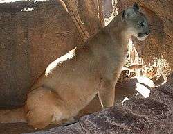
The Simi Hills are the most critical wildlife corridor linkage from the Santa Monica Mountains — to the Santa Susana Mountains, and beyond to the Topatopa Mountains, San Gabriel Mountains, and other Transverse Ranges further east. The Simi's undeveloped native habitat provides routes that protect larger land wildlife of the Santa Monicas from genetic isolation. Large sections of the Simi Hills are protected by parks and open space preserves. Animals in the area include mammals such as the Virginia opossum, ornate shrew, broad-footed mole, mountain lion, mule deer, bobcat, spotted and striped skunk, California badger, southern California weasel, California raccoon, ringtail cat, black bear, Botta's pocket gopher, desert cottontail, valley coyote, gray fox, California vole, brush rabbit, California ground- and California grey squirrel, as well as several species of mice (California pocket mouse, western harvest mouse, brush mouse, deer mouse, and house mouse), rats (agile kangaroo rat, dusky-footed woodrat, black rat, roof rat, and brown rat) and bats (long-eared myotis, long-legged myotis, California myotis, small-footed myotis, western pipistrelle, Brazilian free-tailed bat, western mastiff bat, and Tejon myotis).[107] Some of the reptiles in the area include several species of snakes (coachwhip, southern Pacific rattlesnake, San Diego night snake, striped racer, California black-headed snake, two-striped garter snake, San Diego gopher snake, coast mountain kingsnake, California kingsnake, coast patch-nosed snake, ringneck snake) and lizards (western fence lizard, California side blotched lizard, western skink, western whiptail, San Diego horned lizard, California horned lizard, San Diego alligator lizard, silvery legless lizard).[107] There are ten species of amphibians in Simi Valley: the California newt, western spadefoot, California toad, arroyo toad, California slender salamander, arboreal salamander, American bullfrog, California red-legged frog, California treefrog, and the Pacific treefrog.[108]

Birds in Simi Valley include Anna's hummingbird, Canada goose, mallard, California quail, common egret, great blue heron, American bittern, American coot, killdeer, mourning dove, roadrunner, belted kingfisher, black phoebe, barn swallow, cliff swallow, common raven, common crow, white-breasted nuthatch, cactus wren, mockingbird, robin, cedar waxwing, phainopepla, starling, least Bell's vireo, hooded oriole, western tanager, several species of blackbird (western meadowlark, Brewer's blackbird and brown-headed cowbird) and woodpeckers (common flicker, Nuttall's woodpecker, acorn woodpecker, and yellow-bellied sapsucker). Raptors include turkey vulture, white-tailed kite, American kestrel, poor-will and several species of hawks (Cooper's hawk, sharp-shinned hawk, marsh hawk, red-tailed hawk, red-shouldered hawk, and the common nighthawk) and owls (great horned owl, short-eared owl, long-eared owl, barn owl, and the burrowing owl). Grosbeaks, finches and sparrows include black-headed grosbeak, house finch, American goldfinch, lesser goldfinch, California towhee, Savannah sparrow, sage sparrow, dark-eyed junco, white-crowned sparrow and the house sparrow.[108]
In popular culture

Given its close proximity to Hollywood, Simi Valley has long been a popular entertainment industry location.
- Simi Valley and the surrounding hills have been the site of several television shows, including the long-running series Gunsmoke and M*A*S*H.
- Established in 1937 and opened to the public in 1949, the Corriganville Movie Ranch, established by Ray "Crash" Corrigan, is located at the extreme Eastern end of Simi Valley and was the production site for many movies and television shows. Today the site is open to the public as Corriganville Park, just off the Santa Susana Pass Road.
- The popular 1970s television show Little House on the Prairie utilized an expansive collection of sets constructed throughout the hilly landscapes of Big Sky Ranch in the Tapo Canyon hills north of Simi Valley and Santa Clarita, California. In addition to the Little House itself, the entire set for the town of Walnut Grove was built atop the hills. After finishing his work on the series, Michael Landon blew up the town (which became part of the final movie) but the Little House itself was left intact. In July 2004, the house was destroyed by a devastating California wildfire.[110]
- The 1973 film, The Doberman Gang was filmed entirely in Simi Valley, with the actual Bank of A. Levy as the backdrop for the robbery scenes.
- In 1983, Colleen McCullough's TV mini-series, The Thorn Birds, was brought to life in a remote corner of the Simi Valley. Australia presented too many hurdles for producers, the least of which was the restriction that only two American actors star in any movie filmed there; the rest had to be Australian. Location scouts went scouring, and Simi Valley, some of which strongly resembles parts of the Australian countryside, was chosen for the famous Cleary ranch and sheep station, Drogheda.
- In the 1984 film "Bachelor Party" starring Tom Hanks, the MANN 6 Movie Theater, formerly located within the Sycamore Shopping Center, was used for the movie theater scene.
- The 1986 western comedy film ¡Three Amigos! was partially filmed here.
- The Brandeis-Bardin Institute's House of the Book is the location of the original Power Ranger Power Chamber.
- The 1982 hit horror film Poltergeist was filmed on Roxbury Street in Simi Valley. At the time, the homes were new and the land behind the street was free, allowing plenty of access for studio trucks. 4267 Roxbury Street (the Freeling house in the film) suffered substantial earthquake damage in the 1994 Northridge earthquake.
- For the 1992 movie "Sneakers" with Robert Redford, the Gibraltar Savings building (now Countrywide at 400 Countrywide Way) was transformed to The Playtronics Toy company. The entire front lobby and hallways were redone for the movie and then returned to their original design. Some of the filming was done from hills across from the building. Many scenes were shot at night with the permission of the residents, due to the lighting required.
- The delivery of the ransom money in The Big Lebowski shows a highway sign naming Simi Valley.
- The video for Bullet with Butterfly Wings by The Smashing Pumpkins was filmed in Simi Valley.
- In the 1995 film Species, the character, Dr. Laura Baker, is said to be from Simi Valley.
- In the 1999 comedy Joe Dirt, the character found his long-lost parents in a trailer home park in Simi Valley (On another version of the movie, it was changed to Yucca Valley, California).
- The 1992 children's comedy Honey, I Blew Up the Kid was filmed in and around 676 Coldbrook Pl.
- In the 1992 film Forever Young starring Mel Gibson the test airstrip scenes and the highway chase scene were filmed on the west end of Simi Valley bordering Moorpark.
- Most of the 2003 film adaptation of The Cat in the Hat starring Mike Myers and Dakota Fanning was filmed in Simi Valley. The elaborate faux suburb where most of the film takes place was built on vacant land in a hilly area in West Simi Valley.
- Parts of Viva Rock Vegas, the sequel to the original Flintstones movie, was filmed at Rocky Peak.
- The video for "Hexagram," by The Deftones was filmed with fans watching the band play the song in an indoor skatepark in Simi Valley.
- The 2003 video game Black & Bruised, has a character, Jumping Janet, whose hometown is Simi Valley.
- The skatepark in the 2005 movie Bad News Bears is in Simi Valley.
- In 2005, the PBS children's television series, Postcards from Buster, featured skateboard culture; interviewing local children and visiting the indoor skateboard park, Skatelab.
- The "Retail Rodeo" scenes from the Jennifer Aniston movie The Good Girl were filmed in the Ralph's shopping center on L.A. Ave. The set was constructed inside a vacant retail space.
- Nu-metal band Limp Bizkit filmed the music video for the single "Break Stuff" at Skatelab, a skate park in Simi Valley.
- The 2006 comedy The Benchwarmers was filmed on location in Knolls park and Santa Susana park, both located in Simi Valley.
- In March 2008, G.I. Joe: The Rise of Cobra starting filming in the northern hills above Simi Valley, near the Little House on the Prairie site.
- The Patrick Swayze movie "Three Wishes" used a baseball field in Simi Valley, near the Santa Susana Pass.
- In 2009, the rock band AFI filmed their music video for Beautiful Thieves, the second single from their album Crash Love, in a mansion in Simi Valley.
- The 2009 Hallmark Channel movie "Always and Forever" was filmed in various locations throughout Simi Valley and Moorpark, California.
- In 2009 Gavin Rossdale filmed part of his music video "Forever May You Run" in an office building on 555 E. Easy Street in Simi Valley.
- The fictional "Atmospheric Research Institute" from the 2009 NBC TV miniseries, The Storm, was filmed in an office building on 555 E. Easy Street in Simi Valley.
- 1000 Ways to Die uses the fictional "Simi Valley U" for most college related clips like "Washed and Fried", "Beer Bashed", and "Who Fart-Dead"
- G4's American Ninja Warrior competitions hold their "boot camp" in the mountains of Simi Valley.
- In 2011, WWE Tough Enough chose Hummingbird Ranch, located at north-end of Kuehner Drive in Simi Valley (which is visible when driving east-bound on the 118 Freeway), and was hosted by Stone Cold Steve Austin.
- In 2013, Bunim/Murray Productions used one of the two Simi Valley mansions to film a spin-off for The Bad Girls Club.
- Scenes in Criminal Minds were filmed in various places in Simi Valley, Including an intersection on Cochran St.
- Southern California radio station, KROQ, began hosting a "Punk Rock Prom" contest in early 2000 - two of which Simi Valley high schools won back to back. In 2000, Santa Susana High School won with Blink 182 performing at the school. In 2001, co-winners Santa Susana High School and Simi Valley High School won the contest, which was held at Six Flags Magic Mountain in Santa Clarita, CA, with Weezer and The Offspring headlining the event.
See also
- Santa Susana, CA
- Burro Flats Painted Cave
- History of California before 1900
- List of Registered Historic Places in Ventura County, California
- Ranchos of California
- Santa Susana Pass
References
- ↑ "At A Glance". City of Simi Valley. Retrieved February 25, 2015.
- ↑ "California Cities by Incorporation Date" (Word). California Association of Local Agency Formation Commissions. Retrieved August 25, 2014.
- ↑ "Departments". City of Simi Valley. Retrieved February 11, 2015.
- ↑ "City Council". City of Simi Valley. Retrieved October 13, 2014.
- ↑ "City Manager's Office". City of Simi Valley. Retrieved October 13, 2014.
- ↑ "2010 Census U.S. Gazetteer Files – Places – California". United States Census Bureau.
- ↑ "Simi Valley". Geographic Names Information System. United States Geological Survey. Retrieved October 13, 2014.
- ↑ "Simi Valley (city) QuickFacts". United States Census Bureau. Retrieved February 8, 2015.
- 1 2 https://www.census.gov/popest/data/cities/totals/2014/index.html
- ↑ Lynne McCall & Perry Rosalind (eds.). 1991. The Chumash People: Materials for Teachers and Students. Santa Barbara Museum of Natural History. San Luis Obispo, CA: EZ Nature Books. ISBN 0-945092-23-7. Page 29.
- ↑ Johnson, John R. 1997. Chumash Indians in Simi Valley in Simi Valley: A Journey Through Time. Simi Valley, CA: Simi Valley Historical Society. Page 8-9. ISBN 978-0965944212.
- ↑ Metcalfe, Coll (April 24, 1998). "When It Comes to Saying Simi, There's a Pronounced Difference". Los Angeles Times.
- ↑ https://alt.coxnewsweb.com/statesman/metro/081205libs.pdf
- ↑ http://americancityandcounty.com/administration/study-ranks-americas-most-liberal-and-conservative-cities
- ↑ http://www.vcstar.com/news/republican-presidential-candidates-debate
- ↑ http://www.theatlantic.com/politics/archive/2014/10/First-Republican-2016-Primary-Debate-Scheduled-Ronald-Reagan-Presidential-Foundation/382208/
- ↑
- ↑ "2013 - A Year in Review". Simi Valley News :. City of Simi Valley. January 21, 2014. Retrieved 14 March 2015.
- ↑ http://www.simivalley.org/ftp/cm/2014SotC.pdf
- ↑ http://factfinder2.census.gov/faces/tableservices/jsf/pages/productview.xhtml?pid=ACS_12_5YR_DP03
- ↑ U.S. Census Bureau. American Community Survey, 2011 American Community Survey 5-Year Estimates, Table B19113. American FactFinder. Retrieved October 21, 2013. Archived 31 May 2012 at WebCite
- ↑ Appleton, Bill. 2009. Santa Susana. Mount Pleasant, SC: Arcadia Publishing. ISBN 9781439638200. Page 11.
- ↑ Starr, Kevin. 2007. California: A History. Modern Library Chronicles 23. Random House Digital, Inc. Page 13. ISBN 978-0-8129-7753-0.
- 1 2 Johnson, John R. 1997. Chumash Indians in Simi Valley in Simi Valley: A Journey Through Time. Simi Valley, CA: Simi Valley Historical Society. Page 5. ISBN 978-0965944212.
- ↑ Gamble, L. H., & Enki Library eBook. 2008. The Chumash World at European Contact (1st ed.). University of California Press. Page 26.
- ↑ Johnson, John R. 1997. Chumash Indians in Simi Valley in Simi Valley: A Journey Through Time. Simi Valley, CA: Simi Valley Historical Society. Page 6. ISBN 978-0965944212.
- ↑ Kroeber, Alfred Louis. 1917. Arapaho dialects, Volume 12. Oakland, CA: University of California Press. Page 58.
- ↑ Gudde, Erwin Gustav. 1960.California Place Names: The Origin and Etymology of Current Geographical Names. Oakland, CA: University of California Press. Page 311.
- ↑ Lynne McCall & Perry Rosalind (eds.). 1991. The Chumash People: Materials for Teachers and Students. Santa Barbara Museum of Natural History. San Luis Obispo, CA: EZ Nature Books. ISBN 0-945092-23-7. Page 29.
- ↑ Johnson, John R. 1997. Chumash Indians in Simi Valley in Simi Valley: A Journey Through Time. Simi Valley, CA: Simi Valley Historical Society. Page 8. ISBN 978-0965944212.
- ↑ Harrington, Robert E. 1969. Indian Caves here may be preserved. Marlborough, MA: Enterprise-Sun News. Page 33.
- ↑ Johnson, John R. 1997. Chumash Indians in Simi Valley in Simi Valley: A Journey Through Time. Simi Valley, CA: Simi Valley Historical Society. Pages 8-9. ISBN 978-0965944212.
- ↑ http://www.simivalley.org/index.aspx?page=33
- ↑ Appleton, Bill. 2009. Santa Susana. Mount Pleasant, SC: Arcadia Publishing. ISBN 9781439638200. Page 9.
- ↑ Johnson, John R. 1997. Chumash Indians in Simi Valley in Simi Valley: A Journey Through Time. Simi Valley, CA: Simi Valley Historical Society. Page 9. ISBN 978-0965944212.
- ↑ http://scahome.org/publications/proceedings/Proceedings.26Knight.pdf
- ↑ Bolton, Herbert E. (1927). Fray Juan Crespi: Missionary Explorer on the Pacific Coast, 1769-1774. HathiTrust Digital Library. pp. 267–268. Retrieved July 2014. Check date values in:
|access-date=(help) - ↑ The Chumash
- 1 2 Simi Valley Historical Society
- ↑ Energy Technology Engineering Center Closure Project
- ↑ Department of Toxic Substances Control - Santa Susana Field Laboratory Cleanup Program
- ↑ Hirsch, Daniel (September 18, 2008). "Statement of Dan Hirsch, President, Committee To Bridge The Gap, Before The Committee on Environment and Public Works, U.S. Senate, Oversight hearing" (PDF). Retrieved September 19, 2011.
- ↑ Christian, Jerry D (July 26, 2005). Chemical Behavior of Iodine-131 during SRE Fuel Element Damage in July 1959. Response to Plaintiff's Expert witness Arjun Makajani. (PDF). Retrieved April 2, 2009.
- ↑ U.S. Department Of Energy. "Major Radiological Operations timeline". Retrieved May 5, 2009.
- ↑ Energy Technology Engineering Center Closure Project
- ↑ Cannon, Lou. (1999).Official Negligence : How Rodney King and the Riots Changed Los Angeles and the LAPD. Basic Books: ISBN 0-8133-3725-9
- ↑ "Jury Sworn In for Police Beating Case". New York Times. 1993-02-23.
- ↑ Davidson, Harold A. (1970). Economic analysis of the growth and development of the Simi Valley. Research Institute for Business and Economics, Graduate School of Business Administration, University of Southern California. Page 50.
- ↑ "US Gazetteer files: 2010, 2000, and 1990". United States Census Bureau. 2011-02-12. Retrieved 2011-04-23.
- ↑ Blake, Thomas F. and Robert A. Larson. Engineering geology along the Simi-Santa Rosa Fault system and adjacent areas, Simi Valley to Camarillo, Ventura County, California. Association of Engineering Geologists, Southern California Section. Page 265.
- ↑ Havens, Patricia (1997). Simi Valley: A Journey Through Time. Simi Valley Historical Society and Museum. Page 293. ISBN 978-0965944212.
- ↑ Douglas, Edward Morehouse (1923). Boundaries, Areas, Geographic Centers and Altitudes of the United States and the Several States: With a Brief Record of Important Changes in Their Territory. U.S. Government Printing Office. Page 338.
- ↑ Diller, Joseph Silas (2007). Guidebook of the western United States. Harvard University. Page 101.
- ↑ http://www.idcide.com/weather/ca/simi-valley.htm
- ↑ Havens, Patricia (1997). Simi Valley: A Journey Through Time. Simi Valley Historical Society and Museum. Page 427. ISBN 978-0965944212.
- ↑ U.S. Department of Agriculture (C. Robert Elford). 1970. Soil Survey: Ventura Area, California. Oakland, CA: University of California Press. Pages 142-143.
- 1 2 http://www.weather.com/weather/wxclimatology/monthly/graph/USCA1060
- ↑ "MONTHLY AVERAGES for Simi Valley, CA". The Weather Channel. May 2011. Retrieved September 4, 2008.
- ↑ http://earthquake.usgs.gov/earthquakes/states/events/1994_01_17.php
- ↑ "Annual Estimates of the Resident Population for Incorporated Places: April 1, 2010 to July 1, 2015". Retrieved July 2, 2016.
- ↑ "Census of Population and Housing". Census.gov. Retrieved June 4, 2015.
- ↑ "2010 Census Interactive Population Search: CA - Simi Valley city". U.S. Census Bureau. Retrieved July 12, 2014.
- ↑ U.S. Census Bureau, Census 2010 Summary File 3, Matrices P18, P19, P21, P22, P24, P36, P37, P39, P42, PCT8, PCT16, PCT17, and PCT19
- ↑ "American FactFinder". United States Census Bureau. Retrieved 2008-01-31.
- ↑ 2007 American Community Survey: Simi Valley
- ↑ http://www.politico.com/news/stories/0811/61956.html
- 1 2 http://articles.latimes.com/1991-10-27/news/mn-1031_1_simi-valley
- ↑ Congressional Quarterly (1993). CQ's Guide To 1990 Congressional Redistricting, Part 2. Congressional Quarterly, Inc. Page 39. ISBN 9780871877345.
- ↑ Here Publishing (2004). The Advocate No. 917, Jun. 22, 2004. Page 43. ISSN 0001-8996.
- ↑ CQ Press (2003). Congressional Districts in the 2000s: A Portrait Of America. Pages 115-116. ISBN 9781568028491.
- ↑ http://alt.coxnewsweb.com/statesman/metro/081205libs.pdf
- ↑ http://govpro.com/content/gov_imp_31439/
- ↑ http://www.sos.ca.gov/elections/sov/2008_general/ssov/5-pres-by-political-districts.pdf
- ↑ http://www.sos.ca.gov/elections/sov/2012-general/ssov/pres-by-political-districts.pdf
- ↑ http://www.nbcnews.com/id/18426777/ns/politics-the_debates/t/no-social-conservative-ballot/#.VbZnlRNViko
- ↑ http://www.vcstar.com/news/elections/carly-fiorina-to-speak-on-foreign-policy-at-reagan-library_73727409
- ↑ Newport, Frank (2009). Winning the White House 2008: The Gallup Poll, Public Opinion, and the Presidency. Infobase Publishing. Page 87. ISBN 9781438126876.
- ↑ http://www.dailynews.com/opinion/20140508/endorsement-steve-knight-for-congress-in-californias-25th-district
- ↑ Barraclough, Laura and Laura Pulido (2012). A People's Guide to Los Angeles. University of California Press. Page 241. ISBN 9780520953345.
- ↑ Barraclough, Laura R. (2011). Making the San Fernando Valley: Rural Landscapes, Urban Development, and White Privilege. University of Georgia Press. Page 159. ISBN 9780820336800.
- ↑ http://www.latimes.com/nation/la-na-rep-steve-knight-export-import-20150706-story.html
- ↑ http://www.nytimes.com/2014/09/29/us/politics/midterm-elections-house-republicans.html?_r=0
- ↑ http://www.simivalley.org/Org._Charts_-__12-06_.pdf
- ↑ City of Simi Valley 2008-09 CAFR retrieved 2010-11-29
- ↑ City of Simi Valley Website: Contact Us retrieved 2010-11-29
- ↑ "Statewide Database". UC Regents. Retrieved November 21, 2014.
- ↑ "Communities of Interest - City". California Citizens Redistricting Commission. Retrieved September 27, 2014.
- ↑ Billy Hathorn, "Roy Bean, Temple Houston, Bill Longley, Ranald Mackenzie, Buffalo Bill, Jr., and the Texas Rangers: Depictions of West Texans in Series Television, 1955 to 1967", West Texas Historical Review, Vol. 89 (2013), pp. 112-113
- ↑ Donovan L. Hofsommer, The Southern Pacific, 1901–1985, Texas A&M University Press (1986), p. 18
- ↑ http://www.parks.ca.gov/pages/980/files/sspshp%20archaeology%20resources%20inventory.pdf
- ↑ http://www.parks.ca.gov/pages/980/files/sspshp%20historic%20resources.pdf
- ↑ http://www.americassuburb.com/dates.html
- ↑ "Post Office Location - SIMI VALLEY." United States Postal Service. Retrieved on December 6, 2008.
- ↑ "Post Office Location - KOPY KING." United States Postal Service. Retrieved on December 6, 2008.
- ↑ "Post Office Location - MOUNT MCCOY." United States Postal Service. Retrieved on December 6, 2008.
- ↑ City of Simi Valley CAFR 2012-13
- ↑ Santa Susana High School
- ↑ America's Top 1000 Best High Schools; The Daily Beast; May 20, 2012
- ↑ http://www.simivalleylibrary.org/
- ↑ http://simivalleylibrary.org/sites/default/files/uploads/2013-2014%20Annual%20Report%20FINAL.pdf
- ↑ http://www.rsrpd.org/admin/factsaboutus.html
- ↑ http://www.ci.simi-valley.ca.us/index.aspx?page=36
- ↑ Johnson, John R. 1997. Chumash Indians in Simi Valley in Simi Valley: A Journey Through Time. Simi Valley, CA: Simi Valley Historical Society. Page 431. ISBN 978-0965944212.
- ↑ http://www.rsrpd.org/park/parkaz.html
- ↑ http://www.ci.simi-valley.ca.us/Modules/ShowDocument.aspx?documentid=6868
- ↑ http://www.rsrpd.org/park/maps/simivalleymap.pdf
- 1 2 Johnson, John R. 1997. Chumash Indians in Simi Valley in Simi Valley: A Journey Through Time. Simi Valley, CA: Simi Valley Historical Society. Page 488. ISBN 978-0965944212.
- 1 2 Johnson, John R. 1997. Chumash Indians in Simi Valley in Simi Valley: A Journey Through Time. Simi Valley, CA: Simi Valley Historical Society. Pages 488-489. ISBN 978-0965944212.
- ↑ http://articles.latimes.com/1997/jul/13/local/me-12306
- ↑ Freeman, Roberta (October 31, 2003) Stuff of dreams goes up in smoke at movie ranch Ventura County Star
External links
| Wikimedia Commons has media related to Simi Valley, California. |
| Wikivoyage has a travel guide for Simi Valley. |
- Official website
- City Of Simi Valley other website
- Simi Valley Historical Society
- Simi Valley Hospital
- Simi Valley Acorn Newspaper
- "DTSC-Santa Susana Field Laboratory Site Investigation and Cleanup website". Hosted by the California State Department of Toxic Substances Control, which oversees the investigation and cleanup of chemicals in the soil and groundwater at the SSFL. Project status documents, reports, and public comment materials are available. Retrieved January 13, 2013.
- Movies and Television shows filmed in Simi Valley
 |
Santa Susana Mountains | Santa Susana Mountains | Rocky Peak | |
| Moorpark | |
Santa Susana Pass | ||
| ||||
| | ||||
| Thousand Oaks | Simi Hills | Simi Hills Santa Susana Pass State Historic Park |
Municipalities and communities of Ventura County, California, United States | ||
|---|---|---|
| Cities | 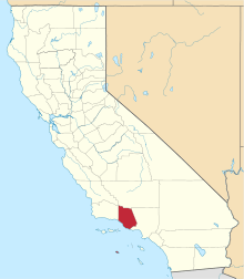 | |
| CDPs | ||
| Unincorporated communities | ||
| Footnotes | ‡This populated place also has portions in an adjacent county or counties | |
| |
^* Mayor selected from city council
|
