South Los Angeles


South Los Angeles is a 51.08-square-mile region of Los Angeles County, California, comprising 25 neighborhoods within the City of Los Angeles and three unincorporated neighborhoods.[1]
Districts and neighborhoods
City of Los Angeles
- Adams-Normandie
- Baldwin Hills/Crenshaw
- Broadway-Manchester
- Central-Alameda
- Chesterfield Square
- Exposition Park
- Florence
- Gramercy Park
- Green Meadows
- Harvard Park
- Historic South Central
- Hyde Park
- Jefferson Park
- Leimert Park
- Manchester Square
- Nevin
- South Park
- University Park
- Vermont Knolls
- Vermont Square
- Vermont Vista
- Vermont-Slauson
- Watts
- West Adams
Unincorporated county
History
Pre-1948
South L.A. is home to the University of Southern California, founded in 1880, as well as the Doheny Campus of Mount St. Mary's College, which was founded in 1920. The 1932 and 1984 Olympic Games took place near the USC campus at neighboring Exposition Park, which hosts the Los Angeles Coliseum. Until the 1920s, West Adams was one of the most desirable areas of the city. Then development of the Wilshire Boulevard corridor drew Los Angeles' development west of downtown. As the wealthy were building stately mansions in West Adams and Jefferson Park, the white working class was establishing itself in Crenshaw and Hyde Park. Affluent blacks gradually moved into West Adams and Jefferson Park as the decades passed.[2]
At the same time, the area of modest bungalows and low-rise commercial buildings along Central Avenue emerged as the heart of the black community in southern California. It had one of the first jazz scenes in the western U.S., with trombonist Kid Ory a prominent resident.[3] Under racially restrictive covenants, blacks were allowed to own property only within the Main-Slauson-Alameda-Washington box and in Watts, as well as in small enclaves elsewhere in the city.[2] The working- and middle-class blacks who poured into Los Angeles during the Great Depression and in search of jobs during World War II found themselves penned into what was becoming a severely overcrowded neighborhood. During the war, blacks faced such dire housing shortages that the Housing Authority of the City of Los Angeles built the virtually all-black and Latino Pueblo Del Rio project, designed by Richard Neutra.[4]
1948–1960s
When the Supreme Court banned the legal enforcement of race-oriented restrictive covenants in 1948's Shelley v. Kraemer, blacks began to move into areas outside the increasingly overcrowded Slauson-Alameda-Washington-Main settlement area. For a time in the early 1950s, southern Los Angeles became the site of significant racial violence, with whites bombing, firing into, and burning crosses on the lawns of homes purchased by black families south of Slauson. In an escalation of behavior that began in the 1920s, white gangs in nearby cities such as South Gate and Huntington Park routinely accosted blacks who traveled through white areas. The black mutual protection clubs that formed in response to these assaults became the basis of the region's fearsome street gangs.[5]
As in most urban areas, 1950s freeway construction radically altered the geography of southern Los Angeles. Freeway routes tended to reinforce traditional segregation lines.[5] The Harbor Freeway ran just to the west of Main Street, and the Santa Monica Freeway just to the north of Washington Boulevard. The Marina Freeway was originally to run near Slauson Avenue all the way to the Orange County line, but was deemed redundant and went unbuilt except for its westernmost portions.
Although the freeways worked in moving cars around, they were decidedly unsuccessful as instruments of integration. The explosive growth of suburbs, most of which barred blacks by a variety of methods, provided the opportunity for whites in neighborhoods bordering black districts to leave en masse. The spread of blacks throughout the area was achieved in large part through "blockbusting," a technique whereby real estate speculators would buy a home on an all-white street, sell or rent it to a black family, and then buy up the remaining homes from whites at cut-rate prices and sell them at a hefty profit to housing-hungry blacks.
This process accelerated after the Watts Riots of 1965. The riots resulted in an abandonment of southern Los Angeles and its neighboring cities by white residents and merchants. Middle-class blacks also left the area, moving to the north and west. By the late 1960s most of Los Angeles south of Pico Boulevard and east of La Brea Avenue had become overwhelmingly black. The Santa Monica Freeway formed the northern boundary of the "new" South Central, primarily dividing the middle-class blacks of Mid-Wilshire from the poor and working-class blacks to the south.
1970s–1990s
Beginning in the 1970s, the precipitous decline of the area's manufacturing base resulted in a loss of the jobs that had allowed skilled union workers to have a middle class life. Downtown Los Angeles' service sector, which had long been dominated by unionized African Americans earning relatively high wages, replaced most black workers with newly arrived Mexican and Central American immigrants.[2]
Widespread unemployment, poverty and street crime contributed to the rise of street gangs in South Central, such as the Crips and Bloods. They became even more powerful with money from drugs, especially the crack cocaine trade, dominated by gangs in the 1980s.[5]
2000s–present
By the 2000s, the crime rate of South L.A. has lowered significantly. Improved policing, community-based peace programs, gang intervention work, and youth development organizations lowered the murder rates to levels not seen since the 1940s and '50s. Nevertheless, South Los Angeles was still known for its gangs at the time.[6] In mid 2003, the City of Los Angeles officially changed the region's name from South Central to South Los Angeles, a move supporters said would "help erase a stigma that has dogged the southern part of the city."[7]
On Aug. 11, 2014, just two days after the shooting of Michael Brown in Ferguson, Missouri, a resident of South Los Angeles, Ezell Ford, described as "a mentally ill 25-year-old man", was fatally shot by two Los Angeles police officers (see Shooting of Ezell Ford).[8] Since then, a number of protests focused on events in Ferguson have taken place in South Los Angeles.[9][10]
Demographics
Population and ethnicity
By the end of the 1980s, South Los Angeles had an increasing number of Hispanics and Latinos, mostly in the northeastern section of the region.[11] But it was not until the 1990s when Hispanic immigrants from Central America began arriving in substantial numbers to buy or rent apartments and houses, most of which were vacated by African Americans. In 1970, nearly 700,000 African-American residents called Los Angeles home. However, in the twenty-year period between 1990 and 2010, the city lost over 125,000 black residents, a number that continues to dwindle as more African-American families seek opportunities elsewhere.[12] Nonetheless, South Los Angeles remains home to the largest black community in the Western United States.
"Between 1970 and 1990 the South LA area went from 80% black and 9% Latino to 50.3% black and 44% Latino."[13] This massive and rapid residential demographic change occurred as resources in the area were shrinking due to global economic restructuring described above and due to the federal government's decrease in funding of urban anti-poverty and jobs programs, and other vital social services like healthcare. The socio-economic context described here increased the perception and the reality of competition amongst Asians, blacks, and Latinos in South LA. The results from the 2000 census which show continuing demographic change coupled with recent economic trends indicating a deterioration of conditions in South LA suggest that such competition will not soon ease."[14]
In the 2000 census, the area of South Los Angeles had a population of 520,461. Roughly 55% of the residents were Hispanic or Latino, while more than 40% were African American.[14]
The "Mapping LA" project of the Los Angeles Times reported that in 2000 the neighborhood had a population of 749,453 in 2000 in its 51.08 square miles, divided into 28 neighborhoods, with 14,671 people per square mile. The ethnic breakdown was Latino, 56.7%; African American, 38%; white, 2.2%; Asian, 1.6% and other, 1.5%.[1]
Landmarks

- Banc of California Stadium (future)
- California African American Museum
- Central Avenue
- Clark Library
- Coca-Cola Building
- Dunbar Hotel
- Exposition Park
- Fire Station No. 30
- Leimert Park
- Lincoln Theater
- Los Angeles Memorial Coliseum
- Los Angeles Sports Arena (formerly)
- King/Drew Medical Center
- Second Baptist Church
- 28th Street YMCA
- University of Southern California
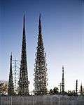
- Watts Towers
Notable people
Music and entertainment
- Ahmad Jones
- Barry White
- Charles Mingus
- Charles Wright & the Watts 103rd Street Rhythm Band
- CJ Mac
- Da Lench Mob
- Dom Kennedy
- Eric Dolphy
- Glasses Malone
- Hampton Hawes
- Ice Cube
- Ice T
- Jay Rock
- John Cage, musician[15]
- Johnny "J"
- K-Dee
- Kausion
- Keb' Mo'
- Kevin McCall
- Kurupt
- L.V.
- Michel'le
- Montell Jordan
- Murs
- Nipsey Hussle
- O.F.T.B.
- Patrice Rushen
- Ras Kass
- Robin Russell, drummer, member of New Birth/Nite-Liters (band)
- Schoolboy Q
- Scott Shaw
- Sir Jinx
- Skee-Lo
- South Central Cartel
- Spider Loc
- Tone Lōc
- Tyrese Gibson
- WC
- Young Maylay
Sports and athletes
Politicians
- Frederick Madison Roberts (South Central, State Assembly 1918–32)
- Augustus Hawkins (South Central, State Assembly 1932–62, U.S. House of Representatives 1962–1991)
- Mervyn M. Dymally (South Central State Assembly 1962–68 & 2002–08, California State Senate 1969–74, Lieutenant Governor of California 1975–79, U.S. House of Representatives 1981–93)
- Gilbert Lindsey (South Central, Los Angeles City Council 1962–91)
- Tom Bradley (South Central, Los Angeles City Council 1963–73, Mayor of the City of Los Angeles 1973–93)
- Billy G. Mills (South Central, Los Angeles City Council 1963–1974, Los Angeles Superior Court Judge 1974–??)
- Julian C. Dixon (South Central, State Assembly 1973–78, U.S. House of Representatives 1979–2000)
- Robert C. Farrell (South Central, Los Angeles City Council 1974–91)
- Yvonne Brathwaite Burke (South Central, State Assembly 1967–73, U.S. House of Representatives 1973–79, Los Angeles County Board of Supervisors 1979–80 and 1992–2008)
- Horace Hiller (1844–1898), member of the Los Angeles Common Council
- Nate Holden (Crenshaw, State Senator 1974–78, Los Angeles City Council 1987–2002)
- Diane Watson (Hyde Park, Los Angeles Unified School District Board 1975–73, State Senate 1978–98, United States Ambassador to Micronesia 1999–2000, U.S. House of Representatives 2001–2011)
- Maxine Waters (Watts, State Assembly 1976–1991, U.S. House of Representatives 1991–present)
- Rita Walters (Crenshaw, Los Angeles Unified School District Board 1979–91, Los Angeles City Council 1991–2001)
- Mark Ridley-Thomas (South Los Angeles, Los Angeles City Council 1991–2002, State Assembly 2002–06, California State Senate 2006–2008, Los Angeles County Board of Supervisors 2008–present)
- Curren Price (South Los Angeles, City Council 1993–97 and 2001–2006, State Assembly 2006–2009, State Senate 2009–present)
- Kevin Murray (Baldwin Hills, State Assembly 1994–98, State Senate 1998–2006)
- Roderick Wright (South Los Angeles, State Assembly 1996–2002, State Senate 2008–present)
- Herb Wesson (South Los Angeles, State Assembly 1998–2004, Los Angeles City Council 2005–present)
- Jan Perry (South Los Angeles, Los Angeles City Council 2002–present)
- Karen Bass (South Los Angeles, State Assembly 2004–2010, U.S. House of Representatives 2011–present)
- Holly Mitchell (South Los Angeles, State Assembly 2010–present)
Artists, filmmakers and writers
- Ron Finley (South LA)
- Mark Bradford (Leimert Park)
- Catherine Opie (South LA)
- David Ayer (South LA)
- Charles Burnett (director) (Watts)
- Cle Sloan
- Wanda Coleman (Watts)
- John Singleton (South LA)
Clergy
- Frederick K. C. Price (Watts)—founder and pastor of Crenshaw Christian Center
- Javier Buelna - founder and pastor of Restauracion Total ( Total Restoration Church )
South Central Revival
Government and infrastructure
The Los Angeles County Department of Health Services operates the South Health Center in Watts, Los Angeles, serving South Los Angeles.[16]
See also
- People
- James G. McAllister, president of the South Los Angeles Property Owners' Protective League and City Council member
- Robert C. Farrell (born 1936), journalist and member of the Los Angeles City Council, 1974–1991, prepared report on unemployment in Watts
- Other regions of Los Angeles County
References
- 1 2 "South L.A.", Mapping L.A. website of the Los Angeles Times
- 1 2 3 Darnell Hunt and Ana-Christina Ramon (eds.). Black Los Angeles: American Dreams and Racial Realities. New York: New York University. ISBN 978-0814737354.
- ↑ Clora Bryant; William Green; Buddy Collette; Steven Isoardi; Marl Young (1999). Central Avenue Sounds: Jazz in Los Angeles. University of California Press. p. 225. ISBN 978-0-520-22098-0.
- ↑ Ehrhard Bahr (2008). Weimar on the Pacific: German Exile Culture in Los Angeles and the Crisis of Modernism. University of California Press. p. 164. ISBN 978-0-520-93380-4.
- 1 2 3 Dunn, William. 2007 The Gangs of Los Angeles. ISBN 978-0-595-44357-4
- ↑ "Gangs of Los Angeles (map)". Google. 2007-05-07. Retrieved 2009-05-28.
- ↑ Matea Gold and Greg Braxton (2003-04-10). "Considering South-Central by Another Name". Los Angeles Times. p. 3. Retrieved 2014-07-17.
- ↑ Mather, Kate; et al. (2014-11-25). "Michael Brown protester handcuffed outside LAPD headquarters". Los Angeles Times. Retrieved 2014-12-14.
- ↑ Nash, Jim (2014-08-14). "Protesters in Leimert Park Join Nationwide 'Day of Rage' Over Ferguson Killing". KTLA 5. Retrieved 2014-12-14.
- ↑ Mather, Kate, and Richard Winton (2014-12-09). "LAPD investigating officer's use of baton during protest". capitalgazette.com. Retrieved 2014-12-14.
- ↑ ""Latinos Move to South-Central L.A. : Drawn by Low Rents, They Replace Blacks," '',''". Los Angeles Times. 1990-05-03. Retrieved 2014-07-17.
- ↑ "Urban flight from Los Angeles: Straight outta Compton". The Economist. 2008-02-14. Retrieved 2014-07-17.
- ↑ Grant, David M., Melvin L. Oliver, and Angela D. James. 1996. "African Americans: Social and Economic Bifurcation," in Waldinger, Roger and Medhi Bozorgmehr. Ethnic Los Angeles, New York: Russell Sage Foundation
- 1 2 Grant, et al. (1996), "African Americans"
- ↑ ""John Cage's Los Angeles," ''Los Angeles Times,'' September 1, 2012". Graphics.latimes.com. Retrieved 2014-07-17.
- ↑ "South Health Center." Los Angeles County Department of Health Services. Retrieved on March 18, 2010.
Further reading
- Renwick, Lucille. "COVER STORY : THE MYTH OF South-Central : More a Stereotype Than a Place, It Is Defined By Ethnicity and Negative Media Images Rather Than Street Boundaries". Los Angeles Times. January 3, 1993.
- Kotkin, Joel (contributing editor of Opinion section) "COMMUNITY: Latinization of South Los Angeles" (Opinion). Los Angeles Times. May 28, 1995.
External links
-
 Media related to South Los Angeles at Wikimedia Commons
 -
 South Central Los Angeles travel guide from Wikivoyage
South Los Angeles region, Los Angeles | ||
|---|---|---|
| Districts and neighborhoods |
|  |
| Points of interest | ||
| Neighboring cities and communities | ||
| Topics |  | |
|---|---|---|
| Government | ||
Coordinates: 33°55′39″N 118°16′38″W / 33.9275°N 118.27722°W