California State Route 1
| ||||
|---|---|---|---|---|
|
Map of California with SR 1 highlighted in red | ||||
| Route information | ||||
| Defined by Streets and Highways Code § 301 | ||||
| Maintained by Caltrans | ||||
| Length: |
655.845 mi[1] (1,055.480 km) (broken into 5 pieces by U.S. Route 101) | |||
| Existed: | 1934 – present | |||
| Tourist routes: |
| |||
| Restrictions: |
Special restrictions'[2]
| |||
| Major junctions | ||||
| South end: |
| |||
| ||||
| North end: |
| |||
| Highway system | ||||
| ||||


State Route 1 (SR 1) is a major north-south state highway that runs along most of the Pacific coastline of the U.S. state of California. At a total of just over 655.8 miles (1,055.4 km), it is the longest state route in California. Highway 1 has several portions designated as either Pacific Coast Highway (PCH), Cabrillo Highway, Shoreline Highway, or Coast Highway. Its southern terminus is at Interstate 5 (I-5) near Dana Point in Orange County and its northern terminus is at U.S. Highway 101 (US 101) near Leggett in Mendocino County. Highway 1 also at times runs concurrently with US 101, most notably through a 54-mile (87 km) stretch in Ventura and Santa Barbara counties, and across the Golden Gate Bridge.
The highway is designated as an All-American Road. In addition to providing a scenic route to numerous attractions along the coast, the route also serves as a major thoroughfare in the Greater Los Angeles Area, the San Francisco Bay Area, and several other coastal urban areas.
SR 1 was built piecemeal in various stages, with the first section opening in the Big Sur region in the 1930s. However, portions of the route had several names and numbers over the years as more segments opened. It was not until the 1964 state highway renumbering that the entire route was officially designated as Highway 1. Although SR 1 is a popular route for its scenic beauty, frequent landslides and erosion along the coast have caused several segments to be either closed for lengthy periods for repairs, or re-routed further inland.
Route description
Highway 1 is part of the California Freeway and Expressway System[3] and is eligible for the State Scenic Highway System.[4] However, only a few stretches between Los Angeles and San Francisco have officially been designated as a scenic highway.[5] The Big Sur section from San Luis Obispo to Carmel is an official National Scenic Byway.[6]
The entire route is designated as a Blue Star Memorial Highway to recognize those in the United States armed forces. In Southern California, the California Legislature has designated the segment between Interstate 5 (I-5) in Dana Point and US 101 near Oxnard as the Pacific Coast Highway (commonly referred to as "PCH"). Between U.S. 101 at the Las Cruces junction (8 miles south of Buellton) and U.S. 101 in Pismo Beach, and between U.S. 101 in San Luis Obispo and Interstate 280 in San Francisco, the legislature has designated State Highway 1 as the Cabrillo Highway, after the Portuguese explorer Juan Rodríguez Cabrillo. The legislature has also designated the route as the Shoreline Highway between the Manzanita Junction near Marin City and Leggett. Smaller segments of the highway have been assigned several other names by the state and municipal governments.[7] The legislature has also relinquished state control of segments within Dana Point, Newport Beach, Santa Monica, and Oxnard; those segments are now maintained by those respective municipalities.[8]
In addition to connecting the coastal cities and communities along its path, Highway 1 provides access to beaches, parks, and other attractions along the coast, making it a popular route for tourists. The route annually helps bring several billion dollars to the state's tourism industry.[9] The route runs right besides the coastline, or close to it, for the most part, and it turns several miles inland to avoid several federally controlled or protected areas such as Vandenberg Air Force Base, Diablo Canyon Power Plant and Point Reyes National Seashore.
Segments of Highway 1 range from a rural two-lane road to an urban freeway. Because of the former, long distance thru traffic traveling between the coastal metropolitan areas are instead advised to use faster routes such as US 101 or I-5.
Orange County

At its southernmost end in Orange County, Highway 1 terminates at I-5 in Capistrano Beach in Dana Point. It then travels west into the city center. After leaving Dana Point, Highway 1 continues northwest along the coast through Laguna Beach (where it meets the southern terminus of California State Route 133) and Crystal Cove State Park.[10][11]
Highway 1 then enters Newport Beach, where it is known as simply Coast Highway. It passes through several affluent neighborhoods, including Newport Coast and Corona Del Mar, spans the entrance to the Upper Newport Bay, which marks the boundary between East Coast Highway and West Coast Highway, and crosses California State Route 55 near its southern terminus. Upon entering Huntington Beach, Highway 1 regains the Pacific Coast Highway designation. It passes Huntington State Beach and the southern terminus of California State Route 39 before reaching Bolsa Chica State Beach and the Bolsa Chica Ecological Reserve. PCH then continues along the coast into Seal Beach, the final city on its journey in Orange County.[10][11]
Los Angeles and Ventura counties
PCH enters Los Angeles County and the city of Long Beach after crossing the San Gabriel River. Highway 1 then continues northwest through the city to its junction with Lakewood Boulevard (State Route 19) and Los Coyotes Diagonal at the Los Alamitos Circle, more than 2 miles (3.2 km) from the coast. From the traffic circle, it continues inland west through Long Beach, including approximately one mile adjacent to the southern boundary of Signal Hill. PCH is marked as such in Long Beach, but originally bore the name of Hathaway Avenue east of the traffic circle and State Street west of there. PCH then passes through the Los Angeles districts of Wilmington and Harbor City. While bypassing the immediate coastline of Palos Verdes, Highway 1 continues to head west into the cities of Lomita and Torrance along the route of the former Redondo-Wilmington Boulevard.[10][11]
PCH then turns north through Redondo Beach and Hermosa Beach. Upon entering Manhattan Beach, it becomes Sepulveda Boulevard and continues through El Segundo and Los Angeles International Airport (LAX), passing under two runways via the Sepulveda Boulevard Tunnel.[10][11]

After leaving LAX, State Highway 1 turns northwest, becoming Lincoln Boulevard and passing through the Los Angeles neighborhoods of Westchester, Playa Vista, Marina Del Rey, and Venice. It then enters the city of Santa Monica, where Highway 1 turns southwest, merging onto the final segment of the Santa Monica Freeway. Passing through the McClure Tunnel, Highway 1 emerges along the beachfront in Santa Monica and continues along the coast; it is known locally also as Palisades Beach Road and formerly as Roosevelt Highway. Upon leaving Santa Monica, it once again regains the name PCH as it follows the coast, curving west through the Pacific Palisades neighborhood of Los Angeles before becoming Malibu's main thoroughfare, spanning the entire 21 miles (34 km) of that city.[10][11]

After leaving Malibu, Highway 1 crosses into Ventura County and continues along the coast through Point Mugu State Park and passes through a notch in the mountain that forms Point Mugu just before entering the Oxnard Plain. The road cut left a very large rock formation at the tip of the point that is called the Mugu Rock. At that point, PCH leaves the coast and heads north, and then northwest as a freeway along the northeastern boundary of Naval Base Ventura County Point Mugu for several miles to an interchange at Rice Avenue, Pleasant Valley Road, and Oxnard Boulevard in Oxnard.[10][11] The reconstructed interchange at Rice Avenue and Pleasant Valley Road channels traffic north on the surface street, Rice Avenue, towards the interchange with US 101. The historic route along Oxnard Boulevard was relinquished in 2014. Truck traffic to and from the Port of Hueneme also uses this designated route at the Rice Avenue/Hueneme Road connector to connect with Route 101 at the Rice Avenue Interchange.[12]
After traveling through Ventura, Highway 1 separates from US 101 to travel along the historic beach route that was originally opened up by the construction of the Railroad Coastal Route from Emma Wood State Beach to the Mobil Pier Undercrossing near Seacliff, where it rejoins US 101 about 3 miles (4.8 km) south of the Santa Barbara County line near La Conchita.[10][11]
Central Coast and Big Sur
The US 101/Highway 1 concurrency (although actual signage mentioning Highway 1 through this segment is nonexistent) from the Mobil Pier Undercrossing runs for 54 miles (87 km), passing through the City of Santa Barbara and its neighboring communities along the coast of Santa Barbara County. The route then turns away from the coast at Gaviota, avoiding Point Conception, and heads due north through Gaviota State Park and the Gaviota Tunnel. In Las Cruces, Highway 1, now named Cabrillo Highway, splits again from US 101 and heads northwest to the city of Lompoc. It is briefly joined with Highway 246 along Lompoc's east-west Ocean Avenue, before turning north as H Street to Harris Grade Road, where it then regains the Cabrillo Highway name.[10][11]
After reaching the main entrance to Vandenberg Air Force Base, Highway 1 turns northeast, away from the immediate coastline of the base, to join Highway 135. Route 135 then splits from Route 1 south of Orcutt, and the Cabrillo Highway turns northwest back towards the coast to Guadalupe. It enters San Luis Obispo County, avoiding the immediate coastline of the protected Guadalupe-Nipomo Dunes, before passing through Grover Beach and subsequently joining US 101 for the third time at Pismo Beach. The US 101/Highway 1 concurrency then avoids the immediate coastline of Avila Beach and Diablo Canyon Power Plant, and instead heads straight inland to San Luis Obispo.[10][11]
Highway 1 splits from US 101 at Santa Rosa Street in San Luis Obispo and then resumes as a four lane road as the Cabrillo Highway. It rejoins the coast in Morro Bay, running through that city as a freeway, where it crosses Morro Creek at the site of a prehistoric Chumash settlement dating to the Millingstone Horizon.[13] From there, Highway 1 proceeds north to Cayucos until it again becomes a winding, two lane road with occasional passing lanes. It then continues along the coast through Cambria and San Simeon, and past the elephant seal colony at Piedras Blancas Light. Highway 1 provides access to the Hearst Castle in San Simeon in Northern San Luis Obispo County.[10][11]
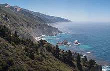
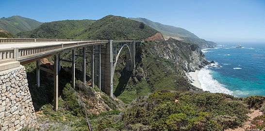
Highway 1 then enters the Big Sur region, crossing the San Carpoforo Creek just south of the Monterey County line. For about 90 miles (140 km) from the San Carpoforo Creek to the Carmel River, the road winds and hugs the cliffs of Big Sur, passing various coastal parks in the area. The road briefly leaves the coast for a few miles and goes through a redwood forest in the Big Sur River valley. This segment of the highway, built between 1919 and 1937, also crosses several historic bridges, including the scenic Bixby Creek Bridge, a reinforced concrete arch with a 320-foot (98 m) span that passes over the Bixby Creek gorge, and the Rocky Creek Bridge.[10][11]
Monterey Bay Area
After crossing the Carmel River, Highway 1 turns inland and runs along just outside the eastern boundary of Carmel before becoming a freeway in Monterey. After bypassing the immediate coastline of Pebble Beach and the rest of the Monterey Peninsula, the freeway heads north along the coast of Monterey Bay through Sand City, Seaside, and Marina. At the interchange with Highway 156 near Castroville, Highway 1 continues north as a two-lane rural road to Moss Landing.[10][11]
Highway 1 becomes a freeway once again just before entering into Santa Cruz County. This four-lane freeway continues up the Monterey Bay coast through Watsonville to its interchange with Highway 17 in Santa Cruz (this trumpet interchange is locally known as The Fishhook due to its tight loop ramps that resemble a fishhook when viewed from above). Upon reaching downtown Santa Cruz, it continues as Mission Street and Coast Road, before regaining the Cabrillo Highway name after it leaves the city and continues north as a two lane road up the coast.[10][11]
San Francisco Bay Area

Entering San Mateo County, Highway 1 follows the west coast of the San Francisco Peninsula, passing by the marine mammal colonies at the Año Nuevo State Reserve, and the historic Pigeon Point Lighthouse, before reaching Half Moon Bay. Between Half Moon Bay and Pacifica, the highway bypasses a treacherous stretch known as Devil's Slide via the Tom Lantos Tunnels.[10][11]
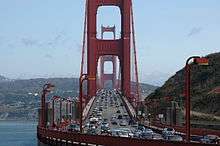

Highway 1 then becomes a freeway once again at Sharp Park in Pacifica before turning inland to join Interstate 280 in Daly City. Just short of reaching the City and County of San Francisco, Highway 1 splits from Interstate 280, where the road becomes Junipero Serra Boulevard. Shortly thereafter, the highway makes a slight left, becoming the six-lane wide 19th Avenue; the San Francisco Municipal Railway's M Ocean View streetcar line runs in the median from this point until a junction to a rail only right-of-way near Rossmoor Drive. Highway 1 then turns into Park Presidio Boulevard after it passes through the city's Golden Gate Park. Then after entering the Presidio of San Francisco, it goes through the MacArthur Tunnel before joining US 101 for a fourth time on the approach to the Golden Gate Bridge known as Doyle Drive.[10][11]
After crossing the bridge and entering Marin County, Highway 1 then splits from US 101 again near Marin City, where it leaves the city and, as the Shoreline Highway, returns to a winding, two lane road as it passes over the Marin Hills to rejoin the coast at Muir Beach. After passing Stinson Beach and the Bolinas Lagoon, Highway 1 avoids the immediate coastline of Point Reyes National Seashore and the rest of the Point Reyes Peninsula, and instead heads towards, and then along, the eastern shore of Tomales Bay.[10][11]
Leaving Tomales Bay, Highway 1 heads further inland to intersect with Valley Ford Road just north of the Sonoma County border. It then rejoins the coast in Bodega Bay, where its name changes to Coast Highway past the Sonoma Coast State Beaches. After bridging the Russian River at Jenner, Highway 1 continues to wind along the rugged coast to Fort Ross, Salt Point State Parks, and the planned community of Sea Ranch.[10][11]
Mendocino County

Highway 1 then crosses the Gualala River and enters Mendocino County. The highway enters the city of Point Arena, in which it becomes Main Street, before following School Street to the northwest and then becoming Shoreline Highway once again. It bridges the Garcia River and then, near Elk, the Navarro River, where it meets Highway 128.[10][11]
At the town of Albion, the Albion River is spanned by the Albion River Bridge, the only remaining wooden trestle bridge on the highway. Highway 1 then passes through Little River and Van Damme State Park, crosses Big River and passes through Mendocino Headlands State Park and the Victorian community of Mendocino. Continuing north, Highway 1 crosses Russian Gulch State Park on the Frederick W. Panhorst Bridge, and passes through the town of Caspar. It passes through a roundabout just south of the intersection with the western terminus of State Highway 20,[14][15] where it widens to two lanes, then bridges the Noyo River at Noyo, becomes Main Street of Fort Bragg, and crosses the California Western Railroad.[10][11]
North of Fort Bragg as a two-lane highway again, Highway 1 passes MacKerricher State Park and the towns of Cleone and Inglenook before crossing Ten Mile River. After passing Westport-Union Landing State Beach, the road goes through a series of redwood-forested switchbacks before reaching Rockport. North of Rockport, the highway turns away from the Lost Coast to avoid steep and unstable highlands created by Mendocino Triple Junction uplift. The highway follows Cottaneva Creek inland through redwood-forested mountainous terrain before terminating at US 101 just outside Leggett.[10][11]
History
SR 1 has become famous worldwide, but the highway was signed as several other routes prior to 1964. When the road was first envisioned in the World War I era, California highways were referred to either by a highway name or by a "Route Number". The route numbers were used by state highway planners and the Legislature from 1915 until 1964, but were never posted on highways, referred to by the auto clubs or public, nor used on maps. The SR 1 designation was first assigned in 1939. Various portions of SH 1 have been posted and referred to by various names and numbers over the years. State construction of what became SR 1 started after the state's third highway bond issue passed before 1910.
Segments initially constructed

Eager for a direct coastal route between Ventura and Santa Barbara, civic boosters used locally raised funds to begin building the Rincon Sea Level Road in 1911. The route between the Ventura River and Carpenteria had been an unimproved route along small alluvial fan beaches that skirted coastal bluff rock outcroppings at low tide.[16] Construction of the Southern Pacific Coast Line railroad had created a road flanked by rip-rap along this area. In order to make this part of the first coastal route for motorists driving from San Francisco to Los Angeles, they paved the road and built wooden causeways where the route flooded from the ocean waves.[17] Local funding ran out but the newly formed State Highway Commission took over and completed the road in 1913.[18]
One of the most difficult routes to build was along the Big Sur coast. The state first approved building Route 56, or the Carmel-San Simeon Highway,[19] to connect Big Sur to the rest of California in 1919. Federal funds were appropriated and in 1921 voters approved additional state funds. San Quentin Prison set up three temporary prison camps to provide unskilled convict labor to help with road construction. One was set up by Little Sur River, one at Kirk Creek and a third was later established in the south at Anderson Creek. Inmates were paid 35 cents per day and had their prison sentences reduced in return. The route necessitated 33 bridges constructed, the largest of which was the Bixby Creek Bridge. Six more concrete arch bridges were built between Point Sur and Carmel.[20]
After 18 years of construction, aided by New Deal funds during the Great Depression, the paved two-lane road was completed and opened on June 17, 1937.[21] The road was initially called the Carmel-San Simeon Highway (Route 56), but was better known as the Roosevelt Highway, honoring the current President Franklin D. Roosevelt. A 1921 law extended Route 56 south over the county road to Cambria.[22]
Route 60, from Oxnard via the coast to San Juan Capistrano, was extended from Oxnard to El Rio (midway to Ventura, now the site of the Oxnard Boulevard interchange with US 101), in 1925. At Point Mugu, a path for the highway was cut through the mountains using surplus World War I explosives, thus creating Mugu Rock.[23] The 1921 legislation, in theory, made Route 60 a continuous coastal loop, with both ends at what became US 101 in Oxnard and at Capistrano Beach (since 1964 the southern terminus of Highway 1 at Interstate 5 in Orange County).[24] Route 56 was extended further south from Cambria to connect to present-day US 101 in San Luis Obispo in 1931.[25]
The route from San Simeon to Carmel (connecting with existing county highways at each end) was one of two sections designated as Highway 1. It and Route 60 were intended as links in a continuous coastal roadway from Oregon to Mexico,[26][27]
A large expansion of the state highway system in 1933 resulted in Route 56 being extended in both directions. To the south, a second section was added, beginning at Pismo Beach on US 101 (Route 2) and heading south through Guadalupe and Lompoc to rejoin US 101 at a junction called Los Cruces (sic), just north of Gaviota Pass. (A short piece near Orcutt and Los Alamos had been part of Route 2, which originally followed present Highway 135 from Los Alamos to Santa Maria.) To the north, Route 56 was continued along the coast from Carmel through Santa Cruz to San Francisco. Several discontinuous pieces were added north of San Francisco, one from Route 1 (US 101) north of the Golden Gate to the county line near Valley Ford, another from the Russian River near Jenner (where the new Route 104 ended) to Westport, and a third from Ferndale to Route 1 near Fernbridge. Except for the gaps in Route 56 north of San Francisco, these additions completed the coastal highway, with other sections formed by Routes 1, 2, and 71.[28][29]
The section of Highway 1 from Santa Monica to Oxnard, via Malibu, went out to contract in 1925 as "Coast Boulevard" but was designated "Theodore Roosevelt Highway" when it was dedicated in 1929. Before the completion of its present alignment in 1937, a narrow, winding, steep road known as Pedro Mountain Road connected Montara with Pacifica. That highway was completed in 1914 and provided competition to the Ocean Shore Railroad, which operated between San Francisco and Tunitas Creek from 1907 to 1920. Highway 1 also used to run along the coast between Pacifica and Daly City but this segment was damaged and rendered unusable after a 5.3 magnitude earthquake on March 22, 1957. A small stub remains near Thornton Beach.
Route 56 along Big Sur was incorporated into the state highway system and re-designated as Highway 1 in 1939. The section of road along the Big Sur Coast was declared the first State Scenic Highway in 1965, and in 1966 the first lady, Mrs. Lyndon B. Johnson, led the official designation ceremony at Bixby Creek Bridge.[30] The route was designated as an All American Road by the US Government.[20]
Signs first posted

California Highway 1 signs first went up after California decided to number its highways, in 1934. But only the section from Santa Barbara County north was posted as Highway 1, that section of the road known Route 56 (Las Cruces to Fernbridge, including the gaps). In Ventura, Los Angeles and Orange counties, Route 60 (San Juan Capistrano to the Oxnard area) became California Highway 3, and a few Route 3 signs were actually posted.[31] But the Route 3 signs were replaced by "U.S. Route 101 Alternate" shields and strips by 1936, as the road was built out; this change also allowed the extension of US 66 to end at another U.S. Route, in Santa Monica.[32]
The gaps of non-state highway along the northern coast were finally filled in by the Legislature in 1951, though the State Department of Public Works was not required to maintain the newly added portions immediately. A short connection from near Rockport to Highway 1 at Leggett was also included,[33] as the existing county road north from Rockport to Ferndale had not yet been paved.[34] The Leggett connection became State Route 208.[35]
The state Legislature in 1963 tossed out the old conflicting Legislative Route Numbers (1964 renumbering), got rid of some famous old U.S. routes, and renumbered many state highways. It abolished US 101A in Los Angeles, Orange and Ventura counties and renumbered it as state Highway 1. The cover of "California Highways" magazine in fall 1964 shows state engineers posting the new shield at Point Mugu.[36] The same year, the Legislature by state law named Highway 1 "Pacific Coast Highway" in Orange, Los Angeles and Ventura counties, "Cabrillo Highway" from Santa Barbara north to San Francisco, and "Shoreline Highway" from Marin County to its northern terminus. Many cities, however, did not change the name of city streets that are part of Highway 1, such as Lincoln and Sepulveda boulevards in Los Angeles, Santa Monica and El Segundo; and Junipero Serra and Park Presidio boulevards in San Francisco. Several other cities and communities like Newport Beach and Bodega Bay merely named their respective city streets as "Coast Highway".
Modern alignments

The freeway portion of Highway 1 from Highway 68 in Monterey to Munras Avenue opened in 1960. The segment from Munras Avenue to the northern border of Sand City and Seaside opened in 1968, and bypasses the original highway alignment of Munras Avenue and Fremont Street in Monterey, and Fremont Boulevard through Seaside. North of Seaside, the freeway was built over the original Highway 1 alignment through Fort Ord in 1973. North of Fort Ord, Highway 1 now veers to the left of the original alignment and bypasses Marina to the west. This segment including the interchange with Highway 156 and the short, 2-lane Castroville Bypass opened in 1976. Originally Highway 1 followed the Highway 156 alignment to the Highway 183 intersection in Castroville, then turned northwest, following the present-day Highway 183 through Castroville before rejoining its existing alignment at the northern terminus of the Castroville Bypass.
Plans to upgrade Highway 1 to a freeway from its southern terminus all the way to Oxnard, including building an offshore causeway from the Santa Monica Pier to Topanga Canyon Boulevard south of Malibu, were ultimately killed by 1971 due to local opposition.[37] In 1980, another section was added northwest of Ventura near Emma Wood State Beach, when several miles of the old two-lane alignment of US 101 were posted as Highway 1 where the freeway had bypassed it in about 1960. Then in 1988, the segment from Purisima Road in Lompoc to Highway 135 was re-routed from Harris Grade Road to the former County Route S20 so it could directly serve Vandenberg Air Force Base.
Construction to bridge the gap in the Lost Coast region between Rockport and Ferndale was eventually abandoned. The steepness and related geo-technical challenges of the coastal mountains made this stretch of coastline too costly for highway builders to establish routes through the area.[38] In 1984, Highway 1 was then re-routed to replace State Highway 208, connecting Rockport and Leggett, while the segment between Ferndale and Fernbridge was renumbered as State Highway 211.[39] Most of the coastline in the area is now part of Sinkyone Wilderness State Park and the King Range National Conservation Area.
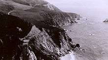
The roadway along Devil's Slide, south of Pacifica, became the site of frequent deadly crashes and roadway-closing landslides. Beginning in 1958, Caltrans supported a plan to construct an inland bypass over Montara Mountain as an alternate route, but was eventually opposed by community and environmental groups who supported a tunnel instead. After decades of legal disputes, the Federal Highway Administration ordered Caltrans in 1995 to re-evaluate the proposed tunnel. Then on November 5, 1996, San Mateo County voters approved Measure T to change the county's official preference from the bypass to the tunnel. Ground eventually broke in 2005, and the Tom Lantos Tunnels opened in April 2013.
In 2014, two-way traffic was restored along the original PCH segment from Copper Lantern to Blue Lantern streets in the Dana Point city center after 25 years of one-way operation.[40] During that period, only northbound traffic had flowed along this section of PCH while southbound traffic had been diverted onto the parallel Del Prado Avenue.
Highway 1 has never been planned to extend south into San Diego, or north into Eureka and Crescent City, where I-5 (which replaced the US 101 designation and signage between Los Angeles and San Diego) and US 101 serve as the coastal highways in those areas, respectively.
As a cycling venue

For the 1932 Summer Olympics, the segment of the Highway 1 between Oxnard and Santa Monica (then known as the Theodore Roosevelt Highway) hosted part of the road cycling events.[41] Portions of Highway 1 have also hosted stages of the Tour of California.[42][43]
Maintenance
California’s coastline is constantly changing and continually presents us with challenges. Through hard work and determination, we continue to keep this scenic highway open.
Landslides
Frequent California landslides and erosion along the coast have caused portions of Highway 1 to either be closed for long periods of time, or be re-routed entirely. Some of these examples include:
- A segment right along the coast between Pacifica and Daly City in what is now Thornton Beach was damaged and rendered unusable after a 5.3 magnitude earthquake on March 22, 1957. Highway 1 was then eventually re-routed to turn inland to join Interstate 280.
- The Piedras Blancas Realignment Project plans to re-route the road up to 475 feet further inland to avoid the expected coastal erosion from the Piedras Blancas Lighthouse to the Arroyo de la Cruz Bridge in San Luis Obispo County.[45]
- The Devil's Slide area has been prone to major landslides. One in 1995 caused the road to be closed for five months, while another in 2006 led to a four-month closure.[46] The Tom Lantos Tunnels, named after former U.S. Congressman Tom Lantos, opened in 2013 to bypass the area.[47]
- Major reconstruction is planned between Muir Beach and Stinson Beach, including the addition of a 523-foot-long, 20-foot-high, but mostly buried, retaining wall. This follows a four-month, $25 million reconstruction that repaired damage from a 2007 landslide.[48]
- A March 2011 landslide in the Big Sur region forced the highway to be closed for several months.[49][50] A section south of Lucia that is also prone to frequent landslides, known as Pitkins Curve and Rain Rocks, is being rebuilt as a bridge and a covered rock shed.[51]
Future projects
In 2014, Caltrans relinquished the portion of Highway 1 in Oxnard along Oxnard Boulevard. The plan is then for PCH between Pleasant Valley Road and US 101 to be re-routed from Oxnard Boulevard onto Rice Avenue.[52][53] That segment of Rice Avenue includes a railroad grade crossing at 5th Avenue that was the site of the February 2015 Oxnard train derailment, which eventually led to one death and 29 injuries. This was the twelfth accident at the crossing in ten years.[54] An overpass has been planned at that site for almost two decades, but funding has not been available in Ventura County for the estimated $35 million grade separation project.[55]
In 2015, a $20 million project was proposed to add over 150 safety improvements to the stretch of the highway in Malibu. This follows a string of fatal accidents in the area, including one involving Caitlyn Jenner that claimed another person's life.[56]
The Calera Parkway project proposes to widen the non-freeway segment in Pacifica between the Rockaway Beach and Vallemar districts, but faces opposition by local residents and environmentalists.[57]
Major intersections
Except where prefixed with a letter, postmiles were measured on the road as it was in 1964, based on the alignment that existed at the time, and do not necessarily reflect current mileage. R reflects a realignment in the route since then, M indicates a second realignment, L refers an overlap due to a correction or change, and T indicates postmiles classified as temporary (for a full list of prefixes, see the list of postmile definitions).[1] Segments that remain unconstructed or have been relinquished to local control may be omitted. The numbers reset at county lines; the start and end postmiles in each county are given in the county column.
| County | Location | Postmile [1][58][59] | Exit [60] | Destinations | Notes | |
|---|---|---|---|---|---|---|
| Orange ORA R0.13-33.72 | Dana Point | R0.13 | Camino Las Ramblas | Continuation beyond I-5 | ||
| R0.13 | Interchange; south end of SR 1; I-5 exit 79 | |||||
| | South end of freeway | |||||
| R0.78 | Coast Highway south, Doheny Park Road – Capistrano Beach | Former US 101 | ||||
| | North end of freeway / North end of state maintenance[lower-alpha 1] | |||||
| 4.32 | Crown Valley Parkway, Monarch Bay Drive | |||||
| Dana Point–Laguna Beach city line | | South end of state maintenance[lower-alpha 1] | ||||
| Laguna Beach | 9.42 | |||||
| Newport Beach | 13.47 | Newport Coast Drive | North end of state maintenance[lower-alpha 1] | |||
| 16.25 | Former SR 73 north; serves John Wayne Airport | |||||
| 17.43 | Jamboree Road – Balboa Island | South end of state maintenance[lower-alpha 1] | ||||
| 19.80 | Interchange; SR 55 exit 1 | |||||
| Huntington Beach | 22.09 | Brookhurst Street – Fountain Valley | ||||
| 23.74 | ||||||
| 25.89 | Goldenwest Street | Interchangeably spelled Golden West Street | ||||
| Sunset Beach | 29.89 | Warner Avenue | ||||
| Seal Beach | 32.72 | Seal Beach Boulevard – Los Alamitos | ||||
| Los Angeles LA 0.00-62.69 | Long Beach | 1.97 | ||||
| 2.75 | Anaheim Street, Los Altos Plaza | |||||
| 3.56 | Lakewood Boulevard, Los Coyotes Diagonal – Downey, Bellflower | Lakewood Boulevard was former US 91 north / SR 18 north / SR 19 north | ||||
| 6.26 | Long Beach Boulevard | |||||
| 7.29 | Interchange; I-710 exit 2 | |||||
| 8.27 | Interchange | |||||
| Los Angeles | 8.43 | 2200-2400 East Pacific Coast Highway – Port of Los Angeles | Interchange | |||
| 9.25 | Alameda Street (SR 47) via O Street | Interchange | ||||
| 10.53 | Avalon Boulevard | |||||
| 11.58 | Figueroa Street | Former US 6 north / SR 11 north | ||||
| 11.61 | Interchange; I-110 exit 4 | |||||
| 12.17 | Vermont Avenue | |||||
| 12.52 | Normandie Avenue | |||||
| 13.10 | ||||||
| Torrance | 14.63 | Crenshaw Boulevard – Rolling Hills | ||||
| 16.01 | ||||||
| Redondo Beach | 19.52 | Torrance Boulevard | ||||
| Manhattan Beach | 21.92 | Artesia Boulevard, Gould Avenue | Former western terminus of SR 91 | |||
| 22.90 | Manhattan Beach Boulevard | |||||
| Manhattan Beach–El Segundo line | 23.92 | Rosecrans Avenue | ||||
| El Segundo | 24.91 | El Segundo Boulevard | ||||
| Los Angeles | 25.92 | Interchange; I-105 exit 1 | ||||
| 26.18 | Airport Tunnel | |||||
| 26.90 | Interchange | |||||
| 27.36 | Interchange | |||||
| | Sepulveda Boulevard | No left turn from SR 1 south | ||||
| 28.50 | Westchester Parkway | Interchange | ||||
| 29.08 | Manchester Avenue – Playa del Rey | Former SR 42 east | ||||
| 31.29 | ||||||
| 31.78 | Washington Boulevard | |||||
| 32.17 | Venice Boulevard (SR 187 east) – Culver City, Venice | |||||
| Los Angeles–Santa Monica city line | | North end of state maintenance[lower-alpha 1] | ||||
| Santa Monica | R34.58 | Interchange. Former western terminus of SR 2. South end of state maintenance.[lower-alpha 1] I-10 east exit 1A, west exit 1B to SR 1 south | ||||
| | South end of freeway | |||||
| 35.17 | McClure Tunnel | |||||
| | North end of freeway | |||||
| 35.18 | Ocean Avenue | Interchange; southbound exit and northbound entrance; former SR 187 east | ||||
| Los Angeles | 39.33 | Sunset Boulevard | ||||
| | 40.77 | |||||
| Malibu | 48.17 | |||||
| 54.02 | ||||||
| 59.90 | ||||||
| | 62.30 | Mulholland Highway | ||||
| Ventura VEN 0.00-43.62[lower-alpha 2] | | | South end of freeway | |||
| | 10.23 | 107 | Las Posas Road – USN Point Mugu | |||
| | 11.59 | 108 | Wood Road – USN Point Mugu | |||
| | 12.79 | 109 | Hueneme Road | |||
| Oxnard | 13.59 | 110 | Nauman Road | No entrance ramps to SR 1; no access across SR 1 | ||
| R14.67 | Hueneme Road | Southbound exit and northbound entrance | ||||
| | North end of freeway | |||||
| 15.06 | Rice Avenue, Pleasant Valley Road | North end of state maintenance.[lower-alpha 1] Rice Avenue is the future re-route of SR 1 to US 101 to bypass Oxnard[52] | ||||
| | South end of freeway | |||||
| 15.93 | 113 | Channel Islands Boulevard | Southbound exit is via Rose Avenue | |||
| | North end of freeway | |||||
| 16.21 | Rose Avenue | No left turns from SR 1 | ||||
| 17.63 | Saviers Road, Wooley Road | Saviers Road was former SR 34 west | ||||
| 18.15 | ||||||
| 20.14 | ||||||
| 21.08 22.73[lower-alpha 2] | Interchange; south end of US 101 overlap; south end of state maintenance;[lower-alpha 1] US 101 exit 62B | |||||
| | South end of freeway on US 101 | |||||
| | 63A | Wagon Wheel Road | Southbound exit only | |||
| Ventura | R23.45[lower-alpha 2] | 63B | Johnson Drive – Montalvo | Signed as exit 63 northbound | ||
| R24.65[lower-alpha 2] | 64 | Victoria Avenue – Channel Islands Harbor | ||||
| 25.97[lower-alpha 2] | 65 | Telephone Road | ||||
| 26.39[lower-alpha 2] | 66A | Signed as exit 66 southbound; no southbound entrance; SR 126 west exit 1A | ||||
| 26.72[lower-alpha 2] | 66B | Main Street (US 101 Bus. north) – Ventura | No southbound exit | |||
| 28.45[lower-alpha 2] | 68 | Seaward Avenue | ||||
| 29.45[lower-alpha 2] | 69 | Vista del Mar Drive, Sanjon Road | Northbound exit and southbound entrance | |||
| 30.15[lower-alpha 2] | 70A | California Street, Ventura Avenue | ||||
| 30.91[lower-alpha 2] | 70B | |||||
| 31.50[lower-alpha 2] | 71 | Main Street (US 101 Bus. south) – Ventura | Southbound exit and northbound entrance | |||
| | | North end of freeway on US 101 | ||||
| Solimar Beach | R32.70[lower-alpha 2] 21.25 | Interchange; northbound exit and southbound entrance; north end of US 101 overlap; US 101 exit 72 | ||||
| Sea Cliff | 27.68 R38.98[lower-alpha 2] | Interchange; south end of US 101 overlap; US 101 exit 78 | ||||
| | | South end of freeway on US 101 | ||||
| | R43.57[lower-alpha 2] | 83 | Bates Road | |||
| Santa Barbara SB R0.00[lower-alpha 2]-50.61 | Carpinteria | R0.63[lower-alpha 2] | 84 | |||
| 1.61[lower-alpha 2] | 85 | Bailard Avenue | ||||
| 2.64[lower-alpha 2] | 86A | Casitas Pass Road | Signed as exit 86 northbound | |||
| 3.06[lower-alpha 2] | 86B | Linden Avenue | Southbound exit and northbound entrance | |||
| 3.77[lower-alpha 2] | 87A | Santa Monica Road | Signed as exit 87 northbound | |||
| | 87B | Carpinteria Avenue | Southbound exit only | |||
| | R5.28[lower-alpha 2] | 88 | Padaro Lane, Santa Claus Lane | |||
| | R7.14[lower-alpha 2] | 90 | Padaro Lane – Summerland | |||
| | R8.26[lower-alpha 2] | 91 | Evans Avenue – Summerland | |||
| Montecito | 9.00[lower-alpha 2] | 92 | Sheffield Drive | |||
| | 10.02[lower-alpha 2] | 93 | San Ysidro Road | |||
| Santa Barbara | 10.54[lower-alpha 2] | 94A | Olive Mill Road, Coast Village Road | No northbound entrance | ||
| | 94B | Hermosillo Drive | Northbound exit only | |||
| 11.41[lower-alpha 2] | 94C | Cabrillo Boulevard, Coast Village Road | Signed as exit 94B southbound, no southbound entrance | |||
| | 95 | Los Patos Way (unsigned) | Southbound exit only | |||
| | 95 | Salinas Street | Northbound exit and entrance | |||
| 12.75[lower-alpha 2] | 96 | Milpas Street | Former SR 144 - northbound exit signed as exit 96A; southbound as exits 96B and 96A | |||
| 13.49[lower-alpha 2] | 96 | Laguna Street, Garden Street - Downtown Santa Barbara | Laguna Street/Garden Street northbound exit signed as exit 96B; Garden Street southbound exit signed as exit 96C | |||
| R14.19[lower-alpha 2] | 97 | Bath Street, Castillo Street (SR 225 west) – Santa Barbara Harbor | ||||
| R14.76[lower-alpha 2] | 98A | Carrillo Street – Downtown Santa Barbara | Signed as exit 98 southbound | |||
| | 98B | Arrellaga Street | Northbound exit and entrance | |||
| R15.73[lower-alpha 2] | 99A | Mission Street | Signed as exit 99 southbound | |||
| | 99B | Pueblo Street | Northbound exit only | |||
| 16.55[lower-alpha 2] | 100 | Las Positas Road | ||||
| 17.78[lower-alpha 2] | 101A | La Cumbre Road, Hope Avenue | ||||
| 18.38[lower-alpha 2] | 101B | |||||
| | | 102 | El Sueno Road | Northbound exit and entrance | ||
| | 20.06[lower-alpha 2] | 103 | Turnpike Road | |||
| Goleta | 21.15[lower-alpha 2] | 104A | Patterson Avenue | Signed as exit 104 southbound | ||
| 21.41[lower-alpha 2] | 104B | Northbound exit and southbound entrance | ||||
| 22.53[lower-alpha 2] | 105 | Fairview Avenue | ||||
| 23.72[lower-alpha 2] | 107 | Los Carneros Road | ||||
| 24.77[lower-alpha 2] | 108 | Glen Annie Road, Storke Road | ||||
| 26.91[lower-alpha 2] | 110 | Winchester Canyon Road, Hollister Avenue | ||||
| | | North end of freeway on US 101 | ||||
| | | South end of freeway on US 101 | ||||
| | 30.06[lower-alpha 2] | 113 | Dos Pueblos Canyon Road | |||
| | | North end of freeway on US 101 | ||||
| | | South end of freeway on US 101 | ||||
| | 32.84[lower-alpha 2] | 116 | El Capitan Ranch Road | |||
| | 33.85[lower-alpha 2] | 117 | El Capitan State Beach | |||
| | 36.62[lower-alpha 2] | 120 | Refugio Road – Refugio State Beach | |||
| | | North end of freeway on US 101 | ||||
| | 44.82[lower-alpha 2] | 128 | Mariposa Reina | Interchange | ||
| | | Gaviota State Beach | ||||
| | 46.30[lower-alpha 2]– 46.90[lower-alpha 2] | Gaviota Rest Area | ||||
| | 47.19[lower-alpha 2] | Gaviota Gorge Tunnel (northbound only) | ||||
| | | South end of freeway on US 101 | ||||
| | | North end of freeway on US 101 | ||||
| Las Cruces | R48.85[lower-alpha 2] R0.00 | Interchange; north end of US 101 overlap; US 101 exit 132 | ||||
| Lompoc | 19.25 | South end of SR 246 overlap | ||||
| 20.57 | North end of SR 246 overlap | |||||
| 23.30 | Harris Grade Road, Purisima Road – Buellton | |||||
| Vandenberg Village | R25.07 | 211 | Constellation Road | Interchange | ||
| Vandenberg AFB | M29.89 | California Boulevard, Lompoc Casmalia Road – Vandenberg AFB | ||||
| | San Antonio Road West – Casmalia | |||||
| M33.30 | San Antonio Road East – Los Alamos | |||||
| M36.19 R31.04 | Interchange; southbound left exit and northbound entrance; south end of SR 135 overlap | |||||
| | | South end of freeway | ||||
| | R34.78 | 226 | Northbound right exit and southbound entrance; north end of SR 135 overlap | |||
| | | North end of freeway | ||||
| | R35.53 | |||||
| Guadalupe | 49.20 | |||||
| San Luis Obispo SLO 0.00-74.32 | Pismo Beach | L16.54 17.75[lower-alpha 2] | Interchange; south end of US 101 overlap; US 101 north via exits 190 or 191B, south via exit 191A | |||
| | South end of freeway on US 101 | |||||
| | R19.81[lower-alpha 2] | 193 | Spyglass Drive, Shell Beach Road | |||
| | R21.11[lower-alpha 2] | 195 | Avilla Beach Drive | |||
| | R22.29[lower-alpha 2] | 196 | San Luis Bay Drive – See Canyon, Avila Beach | |||
| | R24.30[lower-alpha 2] | 198 | Higuera Street | |||
| San Luis Obispo | 25.91[lower-alpha 2] | 200A | Los Osos Valley Road | Signed as exit 200 southbound | ||
| | 200B | Prado Road, Elks Lane | Northbound exit and entrance | |||
| 27.50[lower-alpha 2] | 201 | |||||
| 28.07[lower-alpha 2] | 202A | Marsh Street | ||||
| 28.81[lower-alpha 2] | 202B | Broad Street | ||||
| 29.08[lower-alpha 2] | 203A | Osos Street, Santa Rosa Street | ||||
| | North end of freeway on US 101 | |||||
| 29.08[lower-alpha 2] 16.77 | Interchange; north end of US 101 overlap; US 101 exit 203B | |||||
| | | South end of freeway | ||||
| Morro Bay | 27.88 | 277 | Los Osos/Baywood Park (South Bay Boulevard) | |||
| 28.82 | 278 | Morro Bay Boulevard | ||||
| 29.62 | 279A | Main Street | ||||
| 30.14 | 279B | |||||
| | | North end of freeway | ||||
| | | South end of freeway | ||||
| | R34.91 | 284 | Cayucos (13th Street) | Northbound exit and southbound entrance | ||
| | R35.96 | 285 | Cayucos Drive | |||
| | | North end of freeway | ||||
| | 45.99 | |||||
| Cambria | 48.26 | |||||
| | ||||||
| San Simeon | 56.39 | Hearst Castle | ||||
| | 71.34 | San Carpoforo Creek Bridge | Marks southern end of the Big Sur coastline | |||
| Monterey MON 0.00-R102.03 | | 18.91 | Nacimiento-Fergusson Road | Intersects at the southern end of Kirk Creek Bridge | ||
| | 59.37 | Bixby Creek Bridge | ||||
| | 60.05 | Rocky Creek Bridge | ||||
| | 72.28 | Carmel River Bridge | Marks northern end of the Big Sur coastline | |||
| | 72.92 | |||||
| | | South end of freeway | ||||
| Monterey | 75.14 | 399A | South end of SR 68 overlap | |||
| R75.75 | 399B | Munras Avenue – Monterey | No northbound entrance | |||
| R76.00 | 399C | Soledad Drive, Munras Avenue | Southbound exit and northbound entrance | |||
| R77.38 | 401A | Aguajito Road – Monterey | ||||
| R78.12 | 401B | North end of SR 68 overlap; SR 68 west exit 7B | ||||
| R78.18 | 401B | North Fremont Street | Northbound exit and southbound entrance | |||
| R78.45 | 402A | Casa Verde Way | ||||
| R78.88 | 402B | Del Monte Avenue – Pacific Grove | ||||
| Seaside | R79.36 | 403 | ||||
| Sand City | R80.27 | 404 | Fremont Boulevard, Del Monte Boulevard – Seaside, Sand City | |||
| | R82.89 | 406 | Lightfighter Drive | |||
| Marina | R84.48 | 408 | Imjin Parkway | |||
| R85.14 | 409 | Del Monte Boulevard (SR 1 Bus. north) | Northbound exit and southbound entrance | |||
| R86.48 | 410 | Reservation Road | ||||
| | R88.64 | 412 | Del Monte Boulevard (SR 1 Bus. south) – Marina | |||
| | R90.39 | 414A | Nashua Road, Molera Road | Signed as exit 414 southbound | ||
| Castroville | R90.98 | 414B | Northbound exit and southbound left entrance | |||
| | North end of freeway | |||||
| T92.21 | ||||||
| Moss Landing | 96.10 | Dolan Road – Elkhorn Slough Reserve | ||||
| | | South end of freeway | ||||
| | R101.04 | 423 | Salinas Road | Interchange. Former At-grade intersection | ||
| Santa Cruz SCR R0.00-37.45 | | R0.72 | 425 | |||
| Watsonville | R2.27 | 426 | Harkins Slough Road, Green Valley Road | Northbound exit and southbound entrance | ||
| R2.68 | 426 | Southbound exit and northbound entrance | ||||
| R3.18 | 427 | Airport Boulevard – Freedom | Serves Watsonville Municipal Airport | |||
| | R4.07 | 428 | Buena Vista Drive | |||
| | R6.69 | 431 | Mar Monte Avenue – La Selva | |||
| | R7.66 | 432 | San Andreas Road, Larkin Valley Road | |||
| | 8.35 | 433A | Freedom Boulevard | |||
| | 9.15 | 433B | Rio del Mar Boulevard – Rio del Mar, Aptos | |||
| | 10.54 | 435 | State Park Drive – Seacliff Beach, Aptos | |||
| Capitola | 12.09 | 436 | Park Avenue – Capitola, New Brighton Beach | |||
| 13.19 | 437 | Porter Street, Bay Avenue | ||||
| 13.62 | 438 | 41st Avenue | ||||
| | 14.86 | 439 | Soquel Drive, Soquel Avenue | |||
| Santa Cruz | 15.82 | 440 | Morrissey Boulevard | |||
| 16.63 | 441A | Emeline Avenue | Northbound exit only | |||
| 16.82 | 441B | Signed as exit 441 southbound; SR 17 south exits 1A-B | ||||
| 17.24 | 442 | Ocean Street – Beaches | ||||
| | North end of freeway | |||||
| 17.56 | ||||||
| 19.00 | Bay Street – UC Santa Cruz | |||||
| | 27.62 | Bonny Doon Road – Bonny Doon | ||||
| San Mateo SM 0.00-R48.56 | | 13.58 | Pescadero Road, Pescadero State Beach | |||
| San Gregorio | 18.19 | |||||
| Half Moon Bay | 29.04 | |||||
| | R39.00 | Tom Lantos Tunnels | ||||
| Pacifica | 40.75– 40.96 | Linda Mar Boulevard, San Pedro Avenue | ||||
| 42.01 | Rockaway Beach Avenue, Fassler Avenue – Rockaway Beach | |||||
| R42.58 | Reina Del Mar Avenue | |||||
| | South end of freeway | |||||
| R43.46 | 505A | Sharp Park Road, Fairway Drive – San Bruno | Signed as exit 505 southbound | |||
| R43.74 | 505B | Clarendon Road, Oceana Boulevard | Northbound exit only | |||
| R44.21 | 506 | Paloma Avenue, Francisco Boulevard | Southbound exit and northbound entrance | |||
| R45.12 | 507 | Manor Drive, Monterey Road, Palmetto Avenue | ||||
| Daly City | R46.72 | 508 | Signed as exit 508A (south) and 508B (north) southbound; SR 35 exits 54A-B | |||
| R47.27 | 509A | Serramonte Boulevard, Clarinada Avenue | Signed as exit 509 southbound | |||
| R47.80 R25.28[lower-alpha 3] | 509B | South end of I-280 overlap; no exit number southbound; I-280 north exit 47, south exit 47B | ||||
| R25.78[lower-alpha 3] | 510 | Eastmoor Avenue, Mission Street | Signed as exit 48 southbound | |||
| M27.17[lower-alpha 3] R48.05 | North end of I-280 overlap; southbound exit is exit 511; I-280 north exit 49B, south via exit 50 | |||||
| | 511 | John Daly Boulevard – Daly City, Westlake District | Signed as exit 49A northbound | |||
| City and County of San Francisco SF R0.00-11.18[lower-alpha 2] | | North end of freeway | ||||
| R0.11 | Alemany Boulevard east – Cow Palace | Interchange; northbound exit and southbound entrance | ||||
| R0.31 | Brotherhood Way | Interchange; no northbound exit to Brotherhood Way east and no southbound entrance from Brotherhood Way west | ||||
| R0.68 | Junipero Serra Boulevard, 19th Avenue – San Francisco State University, San Francisco Zoo | No left turn from SR 1 south to Junipero Serra Boulevard north | ||||
| 1.90 | No left turn from SR 1 north to Sloat Boulevard west (SR 35 south) | |||||
| 4.05 | Lincoln Way | No left turns from SR 1 | ||||
| | Geary Boulevard – University of San Francisco | No left turns from SR 1 | ||||
| | South end of freeway | |||||
| 6.33 | MacArthur Tunnel | |||||
| 7.08 9.60[lower-alpha 2] | South end of US 101 overlap; US 101 south was former SR 480 east; US 101 exit 438 | |||||
| 9.71[lower-alpha 2] | 439 | 25th Avenue – View Area, Presidio, Golden Gate NRA, Fort Point | ||||
| Golden Gate | Golden Gate Bridge (Tolled southbound only; no state maintenance on bridge) | |||||
| Marin MRN L0.00[lower-alpha 2]-50.51 | Sausalito | 0.10[lower-alpha 2] | H. Dana Bower Rest Area and Vista Point (northbound only) | |||
| 0.32[lower-alpha 2] | 442 | Alexander Avenue – Sausalito | ||||
| 0.89[lower-alpha 2] | Robin Williams Tunnel through Waldo Grade | |||||
| 1.52[lower-alpha 2] | 443 | Spencer Avenue, Monte Mar Drive | ||||
| 2.48[lower-alpha 2] | 444 | Rodeo Avenue | No access across US 101 | |||
| 3.33[lower-alpha 2] | 445A | Sausalito, Marin City | ||||
| | North end of freeway on US 101 | |||||
| 4.46[lower-alpha 2] 0.00 | Interchange; north end of US 101 overlap; US 101 exit 445B | |||||
| | 0.65 | Almonte Boulevard – Mill Valley | ||||
| | 12.21 | Panoramic Highway – Mount Tamalpais State Park | ||||
| Olema | 26.51 | Sir Francis Drake Boulevard – San Rafael | ||||
| Point Reyes Station | 29.33 | Point Reyes Petaluma Road – Petaluma | ||||
| | 45.36 | Tomales Petaluma Road – Petaluma | ||||
| Sonoma SON 0.00-58.58 | | 0.19 | Valley Ford Road – Petaluma | |||
| | 2.42 | Valley Ford Freestone Road – Occidental, Monte Rio | ||||
| | 5.38 | Bodega Highway – Bodega, Sebastopol | ||||
| | 20.10 | |||||
| Fort Ross | R33.04 | Fort Ross Road – Cazadero, Fort Ross | ||||
| Mendocino MEN 0.00-105.58 | Point Arena | 15.18 | Riverside Drive | |||
| | 40.27 | |||||
| | 43.74 | Albion River Bridge | ||||
| | 52.64 | Frederick W. Panhorst Bridge over Russian Gulch Creek | ||||
| Fort Bragg | 59.80 | |||||
| | 90.87 | Usal Road | ||||
| | 105.50 | Former US 101 | ||||
| | 105.58 | North end of SR 1 | ||||
1.000 mi = 1.609 km; 1.000 km = 0.621 mi
| ||||||
- 1 2 3 4 5 6 7 8 The state has relinquished, and turned over various segments of the highway to local control.
- 1 2 3 4 5 6 7 8 9 10 11 12 13 14 15 16 17 18 19 20 21 22 23 24 25 26 27 28 29 30 31 32 33 34 35 36 37 38 39 40 41 42 43 44 45 46 47 48 49 50 51 52 53 54 55 56 57 58 59 60 61 62 63 64 65 66 67 68 69 70 71 72 73 74 Indicates that the postmile represents the distance along US 101 rather than SR 1.
- 1 2 3 Indicates that the postmile represents the distance along I-280 rather than SR 1.
See also
-
 California Roads portal
References
- 1 2 3 California Department of Transportation. "State Truck Route List". Sacramento: California Department of Transportation. Archived from the original (XLS file) on June 30, 2015. Retrieved June 30, 2015.
- ↑ "Special Route Restrictions". California Department of Transportation. Retrieved July 25, 2014.
- ↑ California Assembly. "Sections 250–257". Streets and Highways Code. Legislative Counsel of California. Retrieved November 29, 2011.
- ↑ California Assembly. "Sections 260–284". Streets and Highways Code. Legislative Counsel of California. Retrieved November 29, 2011.
- ↑ Staff. "Officially Designated Scenic Highways". California Department of Transportation. Retrieved September 14, 2009.
- ↑ Staff. "Big Sur Coast Highway". America's Byways. Federal Highway Administration. Retrieved November 29, 2011.
- ↑ Staff. 2007 Named Freeways, Highways, Structures and Other Appurtenances in California (PDF). California Department of Transportation. pp. 115–116. Retrieved March 28, 2007.
- ↑ California Assembly. "Sections 300–635". Streets and Highways Code. Legislative Counsel of California. Retrieved October 16, 2013.
- ↑ Miller, Heather (June 1999). "The Ups and Downs of Highway 1". Smithsonian magazine. Retrieved July 2, 2013.
- 1 2 3 4 5 6 7 8 9 10 11 12 13 14 15 16 17 18 19 20 Official State Map (Map). Scale not given. Cartography by California Travel Media. California Travel & Tourism Commission. 2010. § E2–M7, N1–X11, AA3–HH8.
- 1 2 3 4 5 6 7 8 9 10 11 12 13 14 15 16 17 18 19 20 Google (January 24, 2015). "Overview Map of State Route 1" (Map). Google Maps. Google. Retrieved January 24, 2015.
- ↑ Green, Nick (January 26, 1996). "City, County to Jointly Seek U.S. Funds for Freeway Link". Los Angeles Times.
- ↑ Hogan, C.Michael (February 25, 2008). "Morro Creek: Ancient Village or Settlement in United States in The West". The Megalithic Portal. Retrieved July 4, 2011.
- ↑ "Fort Bragg's $4.4 million roundabout". Santa Rosa Press-Democrat. May 18, 2011.
- ↑ Staff. "Simpson Lane Intersection". California Department of Transportation. Archived from the original on August 23, 2010. Retrieved July 7, 2011.
- ↑ Yates, Morgan P. (September 2009). "Drive the Planks". Westways. Santa Ana, California. Retrieved December 18, 2014. (subscription required (help)).
- ↑ Historic Resources Group (April 2007). Historic Resources Survey Update, Downtown Specific Plan Area, Prepared for the City of Ventura, California (PDF) (Report). City of Ventura, California. p. 45. Retrieved December 18, 2014.
- ↑ Gyllstrom, Paul (October 17, 1912). "Rincon Sea-Level Road Soon Completed". Motor Age. 22: 24–25 – via Google Books.
- ↑ Newland, Renee. "Bixby Creek Bridge". Monterey County Historical Society. Retrieved November 13, 2011.
- 1 2 "The Building of Highway One". Historical Moments. Cambria Historical Society. Retrieved December 16, 2011.
- ↑ California State Assembly. "An act declaring the county road extending from San Simeon to Cambria to be a state highway and providing for the maintenance thereof". Forty-fourth Session of the Legislature. Statutes of California. State of California. Ch. 837 p. 1606.
- ↑ Jupiter Entertainment (2004). "Pacific Coast Highway". Modern Marvels. The History Channel.
- ↑ California State Assembly. "An act...to construct and maintain...a state highway, extending from the town of Oxnard to a point...at or near the town of El Rio, Ventura county". Forty-sixth Session of the Legislature. Statutes of California. State of California. Ch. 309 p. 508.
- ↑ California State Assembly. "An act establishing certain additional state highways and classifying them as secondary highways". Forty-ninth Session of the Legislature. Statutes of California. State of California. Ch. 82 p. 103.
- ↑ Blow, Ben (1920). California Highways: A Descriptive Record of Road Development by the State and by Such Counties as Have Paved Highways. pp. 182, 232–233, 249 – via Archive.org. Google Books)
- ↑ Howe & Peters. Engineers' Report to California State Automobile Association Covering the Work of the California Highway Commission for the Period 1911–1920 (Report). pp. 11–16 – via Google Books.
- ↑ California State Assembly. "An act to amend sections 2, 3 and 5 and to add two sections to be numbered 6 and 7 to an act entitled 'An act to provide for the acquisition of rights of way for and the construction, maintenance...". Fiftieth Session of the Legislature. Statutes of California. State of California. Ch. 767 p. 2034-2039.: "Ferndale to State Highway Route 1 near Fernbridge." "Russian River near Jenner to Westport." "State Highway near southerly end of Marin Peninsula to the Marin-Sonoma County line via the Coast Route." "Santa Cruz to San Francisco via Coast." "State Highway Route 56 near Carmel to Santa Cruz." "State Highway Route 2 near Las Cruces via Lompoc and Guadalupe to State Highway Route 2 near Pismo."
- ↑ California State Assembly. "An act to establish a Streets and Highways Code, thereby consolidating and revising the law relating to public ways and all appurtenances thereto, and to repeal certain acts and parts of acts specified herein". Fifty-first Session of the Legislature. Statutes of California. State of California. Ch. 29 p. 279.: "Route 56 is from: (a) Route 2 near Los [sic] Cruces via Lompoc and Guadalupe to Route 2 near Pismo. (b) San Luis Obispo to San Francisco along the coast via Cambria, San Simeon, Carmel, and Santa Cruz. (c) State Highway near southerly end of Marin Peninsula to the Marin-Sonoma County line via the Coast Route. (d) Russian River near Jenner to Westport. (e) Ferndale to Route 1 near Fernbridge." "Route 60 is from Route 2 near El Rio via Oxnard to Route 2 south of San Juan Capistrano."
- ↑ Pavlik, Robert C. (November 1996). "Historical Overview of the Carmel to San Simeon Highway" (PDF). Historic Resource Evaluation Report on the Rock Retaining Walls, Parapets, Culvert Headwalls and Drinking Fountains along the Carmel to San Simeon Highway. California Department of Transportation. Retrieved December 17, 2011.
- ↑ "State Routes will be Numbered and Marked with Distinctive Bear Signs". California Highways and Public Works. August 1934.
- ↑ Automobile Route Along the Pacific Coast from Seal Beach to Santa Monica (Map). Automobile Club of Southern California. 1936.
- ↑ California State Assembly. "An act to amend Section 356 of the Streets and Highways Code, relating to state highways". 1951 Session of the Legislature. Statutes of California. State of California. Ch. 1588 p. 3585.
- ↑ Highway Map of California (Map). H.M. Gousha Company. Archived from the original on December 2, 2011., 1955
- ↑ California State Assembly. "An act to add Section 253 and Article 3 (commencing with Section 300) to Chapter 2 of Division 1 of, and to repeal Section 253 and Article 3 (commencing with Section 300) of Chapter 2 of Division 1 of, the...". 1963 Session of the Legislature. Statutes of California. State of California. Ch. 385 p. 1171, 1186.
- ↑ California Highways. September 1964. Missing or empty
|title=(help) - ↑ Masters, Nathan (May 2, 2012). "From Roosevelt Highway to the 1: A Brief History of Pacific Coast Highway". KCET. Retrieved November 17, 2013.
- ↑ "King Range National Conservation Area". Bureau of Land Management. Retrieved June 25, 2012.
- ↑ California State Assembly. "An act...relating to state highways". 1983–1984 Session of the Legislature. Statutes of California. State of California. Ch. 409 p. 1769, 1774.
- ↑ Zhou, Kelly (September 16, 2014). "Dana Point sees two-way traffic flow on Pacific Coast Highway". Orange County Register. Retrieved January 1, 2015.
- ↑ 1932 Summer Olympics Official Report (PDF) (Report). p. 87. Archived from the original (PDF) on July 7, 2010.
- ↑ "2013 Amgen Tour of California to Include San Francisco to Santa Rosa Stage". Santa Rosa Press Democrat. November 27, 2012. Retrieved June 3, 2013.
- ↑ "South County Gearing Up for Amgen Tour Cycling Race". Five Cities Times Press Recorder. May 10, 2013. Retrieved June 3, 2013.
- ↑ Pogash, Carol (March 24, 2013). "New Efforts to Make a Scenic California Highway Less Perilous". The New York Times. Retrieved March 25, 2013.
- ↑ District 5. "Piedras Blancas Realignment Project". California Department of Transportation. Retrieved November 29, 2011.
- ↑ Cabanatuan, Michael (June 19, 2010). "Major Progress on Devil's Slide Tunnel". San Francisco Chronicle. Retrieved August 14, 2011.
- ↑ Mendoza, Martha (February 24, 2013). "Cutting Edge Calif. Tunnels Poised to Open". ABC News. Associated Press. Retrieved February 25, 2013.
- ↑ Johnson, Nate (May 31, 2010). "Highway 1 Repair Plan near Stinson Outlined". Oakland Tribune. Retrieved August 14, 2011.
- ↑ "Highway 1 to Be Closed at Least 1 Month". KSBW. March 18, 2011. Archived from the original on October 4, 2011. Retrieved August 14, 2011.
- ↑ "Landslide Shuts Famed Californian Highway 1 as Big Chunk Falls into the Sea". The Daily Mail. London. March 18, 2011. Retrieved August 14, 2011.
- ↑ District 5. "Pitkins Curve & Rain Rocks". California Department of Transportation. Retrieved August 12, 2012.
- 1 2 Wenner, Gretchen (November 26, 2012). "Oxnard Set to Gain Control of Oxnard Boulevard". Ventura County Star. Retrieved February 24, 2013.
- ↑ Biasotti, Tony (August 27, 2014). "Rice Avenue interchange a turning point for Oxnard". Ventura County Star. Retrieved January 25, 2015.
- ↑ "Metrolink train slams into truck in Oxnard; driver arrested for hit-and-run". Los Angeles: KABC-TV. February 25, 2015. Retrieved February 25, 2015.
- ↑ Weikel, Dan; Nelson, Laura J. (March 1, 2015). "Spending on rail crossing safety upgrades varies widely across Southland". Los Angeles Times. Retrieved March 3, 2015.
- ↑ "$20M Safety Plan Proposed For Malibu's PCH After String Of Traffic Fatalities". Los Angeles: CBS Los Angeles. June 22, 2015. Retrieved July 10, 2015.
- ↑ Kinney, Aaron (February 15, 2014). "Pacifica Residents Rally against Caltrans' Plan to Widen Highway 1". San Mateo County Times.
- ↑ Staff (July 2007). Log of Bridges on State Highways (Report). California Department of Transportation.
- ↑ Staff (2005–2006). All Traffic Volumes on CSHS (Report). California Department of Transportation.
- ↑ Warring, KS (November 7, 2008). "State Route 1 Freeway Interchanges" (PDF). California Numbered Exit Uniform System. California Department of Transportation. Retrieved February 5, 2009; Perry, J (May 21, 2012). "U.S. Route 101 Freeway Interchanges" (PDF). California Numbered Exit Uniform System. California Department of Transportation. Retrieved 2009-02-05.
External links
| Wikimedia Commons has media related to California State Route 1. |
| Wikivoyage has a travel guide for Pacific Coast Highway. |
- Route 1 highway conditions from Caltrans
- State Route 1, California @ AARoads.com
- Route 1 at California Highways
- California's Highway 1, CNN-TravelGuide Pursuits
- California's Pacific Coast Highway from National Geographic
- Guide to California's Highway 1 at Travel + Leisure
- California Highway 1 Attractions at USA Today
- California's Highway 1, The Wine-Lovers' Route at Wine Enthusiast Magazine
- 1958 plans for the conversion of Junipero Serra Boulevard in San Francisco to freeway
- 1964 plans for the conversion of Park Presidio Boulevard in San Francisco to freeway
- Ultimate California Highway 1 road trip at Sunset Magazine
_pictogram.svg.png)