Arroyo Calabasas
| Arroyo Calabasas ('Calabasas Creek') | |
|---|---|
| Country | United States |
| Basin | |
| Main source | Calabasas, California |
| River mouth |
Los Angeles River, California 34°11′43″N 118°36′07″W / 34.1952°N 118.601838°WCoordinates: 34°11′43″N 118°36′07″W / 34.1952°N 118.601838°W[1] |
| Basin size | Santa Monica Mountains, Simi Hills, southwest San Fernando Valley |
Arroyo Calabasas (also known as Calabasas Creek) is a 7.0-mile-long (11.3 km)[2] tributary of the Los Angeles River, in the southwestern San Fernando Valley area of Los Angeles County in California.
Route
The stream begins with the merging of: Dry Canyon Creek from a Santa Monica Mountains watershed and McCoy Canyon Creek from a Simi Hills (Hidden Hills and Upper Las Virgenes Canyon Open Space Preserve) watershed, near the Leonis Adobe in the town of Calabasas.
Arroyo Calabasas flows northeast through Woodland Hills and Canoga Park. In Canoga Park it joins Bell Creek, directly east of Canoga Park High School beside Vanowen Avenue. The confluence marks the "headwaters" of the Los Angeles River, 34°11′43″N 118°36′07″W / 34.1952°N 118.601838°W.
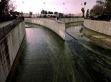
The flow of Arroyo Calabasas is entirely encased in a concrete flood control channel.
Crossings
From mouth to source (year built in parentheses):[3]
- Vanowen Street (1964)
- Westfield Topanga Parking Lot (1964)
- California State Route 27 - North Topanga Canyon Boulevard (1962)
- Kittridge Street [Pedestrian Bridge]
- Victory Boulevard (1966)
- Sylvan Street [Private Pedestrian Bridge]
- Shoup Avenue (1964)
- Oxnard Street (1963)
- Fallbrook Avenue (1961)
- Burbank Boulevard (1968)
- Woodlake Avenue (1968)
- Mariano Street (1968)
- Canzonet Street (1968)
- Dry Canyon Creek enters from south
- Valley Circle Boulevard (1962)
- McCoy Canyon Creek enters from west
See also
- Source (river or stream) - aka: watershed and headwaters
- Confluence - aka: "headwaters"
- Drainage basin - aka: "watershed"
References
- ↑ U.S. Geological Survey Geographic Names Information System: Arroyo Calabasas
- ↑ U.S. Geological Survey. National Hydrography Dataset high-resolution flowline data. The National Map Archived 2012-04-05 at WebCite, accessed March 16, 2011
- ↑ "National Bridge Inventory Database". Retrieved 2009-11-02.
| Districts and neighborhoods |
|  |
|---|---|---|
| Points of interest | ||
| Neighboring cities and communities | ||