California State Route 33
| ||||
|---|---|---|---|---|
 | ||||
| Route information | ||||
| Defined by Streets and Highways Code § 333 | ||||
| Maintained by Caltrans | ||||
| Length: |
289.699 mi[1] (466.225 km) This route is broken into pieces, and the length does not reflect the overlaps that would be required to make the route continuous. | |||
| Existed: | 1934 – present | |||
| Major junctions | ||||
| South end: |
| |||
|
| ||||
| North end: |
| |||
| Highway system | ||||
| ||||

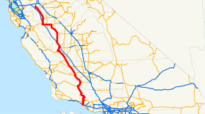
State Route 33 (SR 33) is a north–south state highway in the U.S. state of California. It runs north from Ventura through the Transverse Ranges and the western side of the San Joaquin Valley to a point east of Tracy. SR 33 replaced part of U.S. Route 399 in 1964 during the "great renumbering" of routes. In the unincorporated sections of Kern County it is known as the West Side Highway. In addition, the California Legislature designated the entire Kern County portion as the Petroleum Highway in 2004. The southernmost portion in Ventura is a freeway known as the Ojai Freeway, while it is known as the Maricopa Highway from Ojai to Maricopa.
Route description
Several segments of this route are part of the California Freeway and Expressway System;[2] also, several are eligible to be included in the State Scenic Highway System.[3] However, only the portion from 6.4 miles north of the SR 150 junction to the Ventura - Santa Barbara county line is a scenic highway as designated by Caltrans.[4]
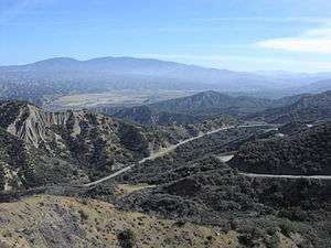
California State Route 33 begins in Ventura as a short freeway ("Ojai Freeway"). SR 33 then continues north as Maricopa Highway, an undivided surface road, through Ojai, following Matilija Canyon past the easternmost extremity of the Santa Ynez Mountains in Los Padres National Forest, and passing over the Transverse Ranges at Pine Mountain Summit. As SR 33 comes down into the Cuyama Valley, it comes up to a junction with SR 166 east of Cuyama. Route 33 continues with Route 166 as they enter Kern County for about 20 miles (32 km) to Maricopa where the routes separate. In Maricopa, Route 33 turns northwest, following the western side of the San Joaquin Valley. Between Taft and Avenal it roughly parallels Interstate 5; for the first 15 miles (24 km) of the portion following the axis of the Midway-Sunset Oil Field. Northwest of Avenal, it turns due west to enter Coalinga, then turns northeast and soon becomes concurrent with I-5 for 13 miles (21 km). Thereafter, it departs due north near Cantua Creek, turns northwest at Mendota, through Firebaugh and meets State Route 152 in Dos Palos, in which it runs concurrently due west for approximately ten miles. It departs again west of Los Banos, turning north to Santa Nella (where it has an interchange with I-5), and roughly parallels I-5 and the San Joaquin River until its northern terminus at I-5 and Bird Road southeast of Tracy.
When passing through the Avenal/Coalinga area travelers pass near a series of prisons and government facilities. They include: Avenal State Prison, Pleasant Valley State Prison, and the new Coalinga Mental Hospital.

In the portions of the route in Kern and Fresno Counties, SR 33 passes through one of the United States' largest petroleum extraction fields, with hundreds of nodding oil pumps along the highway. Some of the fields visible from the highway include the Midway-Sunset, South and North Belridge, Cymric, McKittrick, Lost Hills, and Coalinga oil fields.
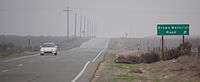
Most of SR 33's route is through sparsely populated, relatively desolate portions of the San Joaquin Valley. Travelers along it should use caution, since emergency services are typically dozens of miles away. Carrying extra water and coolant is especially advised, since summertime temperatures in the area routinely surpass 100 °F (37 °C).
History
Before the US 399 designation was deleted in 1964, SR 33 followed SR 166 east from US 99 at Wheeler Ridge to Maricopa in lieu of the segment from Ventura to Maricopa, and followed the old US highway from Taft to Maricopa. Today, SR 166 remains on the segment between Wheeler Ridge and Maricopa.
SR 33 used to extend north to Interstate 205 in Tracy, but this segment was relinquished after the segment of Interstate 5 from SR 33 to I-205 was completed.
Major intersections
Except where prefixed with a letter, postmiles were measured on the road as it was in 1964, based on the alignment that existed at the time, and do not necessarily reflect current mileage. R reflects a realignment in the route since then, M indicates a second realignment, L refers an overlap due to a correction or change, and T indicates postmiles classified as temporary (for a full list of prefixes, see the list of postmile definitions).[1] Segments that remain unconstructed or have been relinquished to local control may be omitted. The numbers reset at county lines; the start and end postmiles in each county are given in the county column.
| County | Location | Postmile [1][5][6] | Destinations | Notes | ||||
|---|---|---|---|---|---|---|---|---|
| Ventura VEN 0.00-57.51 | Ventura | 0.00 | Southbound exit and northbound entrance; south end of SR 33 | |||||
| 0.17 | Main Street – Ventura | Southbound exit and northbound entrance | ||||||
| | 1.57 | Stanley Avenue | Southbound exit and entrance are on the left | |||||
| | 2.65 | Shell Road | ||||||
| | R4.49 | Cañada Larga Road | ||||||
| | R5.64 | Casitas Vista Road | ||||||
| | North end of freeway | |||||||
| Mira Monte | 11.21 R14.41[N 1] | South end of SR 150 overlap | ||||||
| Ojai | 16.58[N 1] 11.21 | North end of SR 150 overlap | ||||||
| | 48.50 | |||||||
| Santa Barbara SB 0.00-8.18 |
No major junctions | |||||||
| San Luis Obispo SLO 0.00-4.95 | | 2.80 | South end of SR 166 overlap | |||||
| Kern KER 0.00-73.74 | Maricopa | R11.56 | North end of SR 166 overlap | |||||
| Taft | 17.89 | Former US 399 north | ||||||
| McKittrick | 33.45 | South end of SR 58 overlap | ||||||
| 34.29 | North end of SR 58 overlap | |||||||
| Blackwells Corner | 60.09 | Former US 466 | ||||||
| Kings KIN 0.00-18.99 | | 7.80 | ||||||
| Avenal | 17.14 | |||||||
| Fresno FRE 0.00-R83.05 | Coalinga | 15.37 | ||||||
| 15.71 | South end of SR 198 overlap | |||||||
| | 24.32 | North end of SR 198 overlap | ||||||
| | R29.02 17.96[N 2] | Interchange; south end of I-5 overlap | ||||||
| | South end of freeway on I-5 | |||||||
| | North end of freeway on I-5 | |||||||
| | 29.96[N 2] R39.82 | Interchange; north end of I-5 overlap | ||||||
| | 59.43 | |||||||
| Mendota | 61.45 | |||||||
| 62.25 | ||||||||
| Firebaugh | 70.19 | |||||||
| Merced MER R0.00-30.00 | | R5.64 R32.37[N 3] | Interchange; south end of SR 152 overlap | |||||
| Los Banos | 21.27[N 3] | |||||||
| | 13.85[N 3] | Interchange | ||||||
| | 11.27[N 3] R13.24 | Interchange; north end of SR 152 overlap | ||||||
| Santa Nella | R16.64 | Interchange | ||||||
| Gustine | 26.46 4.35[N 4] | South end of SR 140 overlap | ||||||
| 6.06[N 4] 27.11 | North end of SR 140 overlap | |||||||
| Stanislaus STA 0.00-27.09 | | 2.06 | ||||||
| Crows Landing | 6.84 | |||||||
| Patterson | 12.57 | South end of CR J17 overlap | ||||||
| 13.18 | North end of CR J17 overlap | |||||||
| Westley | 19.55 | |||||||
| San Joaquin SJ 0.00-5.00 | Vernalis | 0.82 | Interchange | |||||
| | 4.83 | Interchange; north end of SR 33 | ||||||
| | 5.00 | Ahern Road – Tracy | Continuation beyond I-5; former SR 33 north | |||||
1.000 mi = 1.609 km; 1.000 km = 0.621 mi
| ||||||||
- 1 2 Indicates that the postmile represents the distance along SR 150 rather than SR 33.
- 1 2 Indicates that the postmile represents the distance along I-5 rather than SR 33.
- 1 2 3 4 Indicates that the postmile represents the distance along SR 152 rather than SR 33.
- 1 2 Indicates that the postmile represents the distance along SR 140 rather than SR 33.
References
- 1 2 3 California Department of Transportation. "State Truck Route List". Sacramento: California Department of Transportation. Archived from the original (XLS file) on June 30, 2015. Retrieved June 30, 2015.
- ↑ CA Codes (shc:250-257)
- ↑ CA Codes (shc:263.3)
- ↑ "Officially Designated State Scenic Highways and Historic Parkways". California Department of Transportation. December 7, 2007. Retrieved June 22, 2011.
- ↑ California Department of Transportation, Log of Bridges on State Highways, July 2007
- ↑ California Department of Transportation, All Traffic Volumes on CSHS, 2005 and 2006
Additional reading
- King, Peter H. (July 7, 2008). "A workaday road that cuts through the state's back story: Two-lane Highway 33 isn't a fabled route, but it's rugged and real". Los Angeles Times: A1, A8.
External links
| Wikimedia Commons has media related to California State Route 33. |