San Gabriel Mountains
| San Gabriel Mountains | |
|---|---|
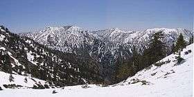 Summits in the eastern San Gabriel Mountains, Angeles National Forest, San Bernardino County, California. The main peaks are: Telegraph Peak, 8,985' (left), Cucamonga Peak, 8,859' (center), and Ontario Peak, 8693' (center right), as seen from Baldy Bowl on Mount Baldy. | |
| Highest point | |
| Peak | Mount San Antonio |
| Elevation | 10,064 ft (3,068 m) |
| Dimensions | |
| Length | 68.4 mi (110.1 km) |
| Width | 22.5 mi (36.2 km) |
| Area | 970 sq mi (2,500 km2) |
| Geography | |
 | |
| Country | United States |
| State | California |
| Counties | Los Angeles and San Bernardino |
| Range coordinates | 34°17′N 117°39′W / 34.29°N 117.65°WCoordinates: 34°17′N 117°39′W / 34.29°N 117.65°W |
The San Gabriel Mountains are a mountain range located in northern Los Angeles County and western San Bernardino County, California, United States.[1] The mountain range is part of the Transverse Ranges and lies between the Los Angeles Basin and the Mojave Desert, with Interstate 5 to the west and Interstate 15 to the east. This range lies in, and is surrounded by, the Angeles National Forest, with the San Andreas Fault as the northern border of the range.
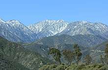
The highest peak in the range is Mount San Antonio, commonly referred to as Mt. Baldy. Mount Wilson is another famous peak, famed for the Mount Wilson Observatory and the antenna farm that houses many of the transmitters for local media. The observatory may be visited by the public. On October 10, 2014, President Obama designated the area the San Gabriel Mountains National Monument.[2]
Geography
Much of the range features rolling peaks. The range lacks craggy features, but contains a large number of canyons and is generally very rugged and difficult to traverse. The San Gabriel Mountains are in effect a large fault block that was uplifted and then dissected by numerous rivers and washes.
Setting and elevation
The highest elevation, Mount San Antonio at 10,064 feet (3,068 m), rises towards the eastern extremity of the range which extends from the Cajon Pass (Interstate 15 Freeway) on the east, where the San Gabriel Mountain Range meets the San Bernardino Mountain Range, westward to meet the Santa Susanna range at Newhall Pass (Interstate 5 Freeway).
North of San Fernando, the San Gabriel Mountains crest abruptly up to almost 4,000 feet (1,200 m). Pacoima and Big Tujunga Canyons cut through the range just east of San Fernando, carrying runoff into the San Fernando Valley. Little Tujunga Canyon Road bridges the range in this area, connecting the San Fernando Valley to the Santa Clara River valley in the north. Towering over Big Tujunga Canyon north of Big Tujunga Reservoir is Mount Gleason, which at 6,502 feet (1,982 m), is the highest in this region of the San Gabriels. South of the gorge are the southern "foothills" of the mountains, which rise abruptly 4,000 feet (1,200 m) above the Los Angeles Basin and give rise to the Arroyo Seco, a tributary of the Los Angeles River.
Southeast of Big Tujunga Canyon, the southern front range of the San Gabriels gradually grows in elevation, culminating in notable peaks such as Mount Wilson at 5,710 feet (1,740 m). On the north the range is abruptly dissected by the canyon of the West Fork San Gabriel River. Even further north the range slopes up into the towering main crest of the San Gabriels, a sweeping arc-shaped massif 30 miles (48 km) in length that includes most of the highest peaks in the range: Waterman Mountain, at 8,038 feet (2,450 m); Mount Islip, at 8,250 feet (2,510 m), Mount Baden-Powell, at 9,399 feet (2,865 m), Pine Mountain, at 9,648 feet (2,941 m), and finally Mount San Antonio, the highest peak in the range at 10,068 feet (3,069 m).
On the north slopes of the San Gabriel crest, the northern ranks of mountains drop down incrementally to the floor of the Mojave Desert in a much more gradual manner than the sheer southern flank. The Angeles Crest Highway, one of the main routes across the San Gabriels, runs through this area from west to east. Little Rock, Big Rock and Sheep Creeks drain off the northern part of the mountains, forming large alluvial fans as they descend into the Mojave. To the east, the San Andreas Fault cuts across the range, forming a series of long, straight and narrow depressions, including Swarthout Valley and Lone Pine Canyon. South of Mount San Antonio, San Antonio Creek drains the mountains, cutting the deep San Antonio Canyon.
East of San Antonio Canyon, the range gradually loses elevation, and the highest peaks in this section of the mountain range are in the south, rising dramatically above the Inland Empire cities of Claremont, Upland and Rancho Cucamonga. However, there are still several notable peaks in this region, including Telegraph Peak, at 8,985 feet (2,739 m), Cucamonga Peak, at 8,859 feet (2,700 m), and Ontario Peak, rising 8,693 feet (2,650 m). Lytle Creek, flowing generally southeast, drains most of the extreme eastern San Gabriels. The range terminates at Cajon Pass, through which runs Interstate 15, and beyond which rise the even higher San Bernardino Mountains.
Locale
The Range is bound on the north by the Antelope Valley and the Mojave Desert and to the south by the communities of greater Los Angeles area. In the western portion of the San Gabriel Mountain Range, the Sierra Pelona Ridge stretches from approximately Soledad Canyon (14 Freeway and railroad right-of-way), formed by the Santa Clara River. The Sierra Pelona Ridge includes Liebre Mountain, Sawmill Mountain, Grass Mountain, Redrock Peak, Burnt Peak, most of which is part of the Angeles National Forest, but also features several rural communities.
Hydrology

Melting snow and rain runoff on the south side of the San Gabriels' highest mountains give rise to its largest river, the San Gabriel River. Just to the west of Mount Hawkins, a north-south divide separates water running down the two main forks of the river and their tributaries. The West Fork, beginning at Red Box Saddle, runs 14 miles (23 km) eastward, and the East Fork, starting north of Mount San Antonio, flows 18 miles (29 km) south and west through a steep, rugged and precipitous gorge. The two meet at San Gabriel Reservoir, and turn south, boring through the southern portion of the San Gabriels, emptying out of the mountains near Azusa into the urban San Gabriel Valley, and eventually to the Pacific Ocean near Seal Beach.
Peaks


San Gabriel Mountains peaks within the Angeles National Forest include:
- Mount San Antonio (Mount Baldy), 10,064 ft (3,068 m)
- Pine Mountain, 9,648 ft (2,941 m)
- Dawson Peak, 9,575 ft (2,918 m)
- Mount Harwood, 9,552 ft (2,911 m)
- Mount Baden-Powell, 9,399 ft (2,865 m)
- Throop Peak, 9,138 ft (2,785 m)
- Mount Burnham, 9,001 ft (2,744 m)
- Telegraph Peak, 8,985 ft (2,739 m)
- Cucamonga Peak, 8,859 ft (2,700 m)
- Ontario Peak, 8,693 ft (2,650 m)
- Timber Mountain, 8,307 ft (2,532 m)
- Mount Islip, 8,250 ft (2,510 m) — site of historic Mt. Islip fire lookout tower [3]
- Waterman Mountain, 8,038 ft (2,450 m)
- Iron Mountain, 8,007 ft (2,441 m)
- South Mount Hawkins, 7,783 ft (2,372 m) — lookout destroyed in Curve Fire, 2002
- Mount Gleason, 6,502 ft (1,982 m)
- Strawberry Peak, 6,164 ft (1,879 m)
- San Gabriel Peak, 6,162 ft (1,878 m)
- Mount Disappointment, 5,960 ft (1,820 m)
- Vetter Mountain, 5,911 ft (1,802 m) — site of historic Vetter Mountain Fire lookout tower
- Mount Wilson, 5,710 ft (1,740 m) — location of the Mount Wilson Observatory
- Mount Lowe, 5,703 ft (1,738 m) — site of Mount Lowe Railway
- Smith Mountain, 5,111 ft (1,558 m)
- Mount Lukens, 5,074 ft (1,547 m)
- Echo Mountain, 3,210 ft (980 m)
Climate
The climate of the range is Mediterranean, with mostly dry summers (except for rare summer thunderstorms) and cold, wet winters. Snow can fall above 4,000 feet elevation during frontal passages between November and April, but is most common in December through March. Annual precipitation totals are mostly above 25 inches above 3,000 feet elevation, with up to 40 inches falling in some areas above 5,000 feet. The coastal (south) side of the range receives more precipitation than the desert (northern) side. The highest precipitation is found in the central and eastern parts of the range (Mt. Wilson to Mt. San Antonio). Annual precipitation totals can be extremely high during wet "El Nino" years, sometimes over 70 inches, with single storm totals over 10 inches. Runoff from the mountains during big storms often produces flooding in adjacent foothill communities (especially in areas denuded by wildfires). Fires are a problem during summer and fall, before the rains come, especially during dry "Santa Ana" wind events. The range is mostly smog free above 5,000 feet elevation, above the inversion layer. The large telescope installation at Mt. Wilson is a testimony to the clear atmospheric conditions that prevail, although light pollution from the L.A. basin below has hindered telescope activities in recent decades.
Geology
Granitic and metasedimentary rocks are the primary constituent of the San Gabriel Mountains. These rocks, of upper Precambrian to Mesozoic age, are the remnants of the ancient North American platform that used to reach into California. Like nearly all of the other mountains in the Transverse Ranges, the San Gabriels are a series of fault blocks there were uplifted in the Cenozoic.[4]
Ecology
There are both areas of conifer as well as broadleaf forestation, including the presence of some endemic taxa. Conifer (pine, fir, cedar) and oak forests are most widespread above 5,000 feet where the precipitation is above 30 inches (the central and eastern high San Gabriels). In the wetter areas, madrone and bay laurel trees also occur in places, and ferns are common. Trees like willow, alder and cottonwood are also found throughout the range along the stream courses (riparian habitat), even at lower elevations. Chaparral (dense shrub, brush and small tree) vegetation is widespread where there is not continuous tall tree cover, especially at lower elevations. Chaparral is highly adapted to fire, and replaces trees for decades after fires. There is a subspecies of the Leather Oak which is found only within the San Gabriel Mountains.[5] The Rift Zone along the San Andreas Fault produces numerous springs, sag ponds, and wetland areas that are critical habitat for a variety of native species.
Larger animals include mule deer, black bear, coyote and the rarely seen puma (mountain lion or cougar). Smaller mammals include raccoon, opossum, skunk and bobcats. Golden and bald eagles are found rarely, but hawks are common. Rattlesnakes are common, and one should be on the lookout for them when hiking.
Transportation

The main road that runs through the San Gabriel Mountains is the Angeles Crest Highway, State Route 2. It starts in the southwest at the city of La Cañada Flintridge and ends at its junction with State Route 138, just past Wrightwood, near the Victor Valley and the West Cajon Valley. Past its junction with Angeles Forest Highway, traveling east, Angeles Crest Highway features blind curves, various bumps, and potholes. This section of the "Crest" is closed during the winter due to rockfall and avalanche hazards. State Route 2, just past Mountain High, is called the Big Pines Highway all the way to the Route 138 junction.
Another key county route which connects Angelenos to, and through, the mountains is Angeles Forest Highway. Angeles Forest Highway begins 11 miles northeast of La Cañada Flintridge at its Angeles Crest Highway junction. Ending near Acton, it allows easy access to the central Forest and the fast-growing Antelope Valley. Because the "Forest" and the 11 mile "Crest" portion leading to La Cañada Flintridge is well traveled by Antelope Valley commuters, its road maintenance is much better, and it is open much of the winter.
State Route 39 connected the city of Azusa with the Angeles Crest Highway until it was seriously damaged by landslides, first in 1978, and again in 2005. The highway was opened to emergency crews in February 2003. The proposed State Route 39 Roadway Rehabilitation Project would begin five miles (8 km) north of Crystal Lake Recreation Area Campground.
According to the Caltrans District Seven "Inside Seven" Newsletter, work will continue through 2009 and 2010 on reconstruction. As written in the newsletter, "Two projects that will address those issues and get the highway reopened are scheduled for construction soon. The first, building two retaining walls near the city of Azusa from Old San Gabriel Canyon Road to approximately four miles south of SR-2, could begin in mid-2009. The second, a $45 million project to reconstruct the roadway, construct soldier pile retaining walls, repair drainage systems, install rock fall protection, and provide asphalt concrete overlay and traffic striping, should begin in fall 2010."(source)
People heading to Mount Waterman must now travel west to Pasadena and then travel on the Angeles Crest Highway (Highway 2) in La Canada Flintridge - a nearly two-hour trip. Reopening Highway 39 would cut the drive-time to the Waterman Ski Area in half and shorten the trip east to Wrightwood. The segment connecting the Crystal Lake Recreation Area to Route 2 is not scheduled to reopen before 2015.
Recreation

In the winter, snowboarding and snow skiing are quite popular in the San Gabriels, at Mountain High and Mt. Baldy. The two other resorts, Mount Waterman and Kratka Ridge, are rarely open. In the summer, "canyoneering", hiking, backpacking, picnicking and camping are some of the activities popular with visitors. From time to time, a hiker gets lost or stuck on a mountain ledge, or may fall downhill. Some of the more extreme cases of emergency search-and-rescue efforts will often be given air time on Los Angeles television and radio newscasts. The Pacific Crest Trail passes along the mountain ridge.
During the winter, many Southern California mountaineers climb a variety of snow routes and even some ice routes in the San Gabriel Mountains. Baldy Bowl is by far the most popular route, getting hundreds of climbers per season. There are many other routes, offering a variety of choices.
Rock climbing is not as common in the San Gabriel Range as it is in neighboring areas, as this range is famous for loose rock. Various faults crisscross the range, making it one of the steepest and fastest-growing ranges in the world [citation needed]. Plate tectonic activity breaks up most rock, making it unsuitable for rock climbing. Williamson Rock was the most famous climbing area, until it was closed for climbing. There are many other craggy areas scattered about the range that provide mostly traditional climbing opportunities.
Angeles National Forest Fire Lookout Association has rebuilt and operates Vetter Mountain Lookout, and Slide Mountain Lookout. The organization is rebuilding South Mount Hawkins Lookout.


Nearby ranges
- San Rafael Hills
- Santa Ana Mountains
- Verdugo Mountains
- San Bernardino Mountains
- Santa Susana Mountains
- Santa Monica Mountains
- Sierra Pelona Mountains
- Tehachapi Mountains

References
- ↑ "San Gabriel Mountains". Geographic Names Information System. United States Geological Survey. Retrieved 2009-05-03.
- ↑ "President Obama Designates San Gabriel Mountains National Monument". The Whitehouse. Retrieved 10 October 2014.
- ↑ USFS.gov: Mt. Islip fire lookout tower
- ↑ USGS
- ↑ C.Michael Hogan. 2010. Leather Oak, Quercus durata. Encyclopedia of Earth. National Council for Science and Environment. Washington DC
External links
| Wikimedia Commons has media related to San Gabriel Mountains. |
- Outdoor LA Hiking Trails – Hiking trails in the area with maps and directions to the trailheads.
- Geographic, Biological, and Geological information
 |
Santa Clarita & CA 14 - Antelope Valley | Palmdale - CA 138 - Mojave Desert - High Desert | Hesperia | |
| Santa Susana Mountains I-5 | |
I-15 - San Bernardino Mountains - Cajon Pass | ||
| ||||
| | ||||
| San Fernando Valley - Crescenta Valley | San Gabriel Valley - I-210 | San Bernardino |