Aliso Viejo, California
| Aliso Viejo, California | ||
|---|---|---|
| City | ||
|
The Aliso Viejo Town Center | ||
| ||
| Motto: "Live, Work, Learn, Shop and Play."[1] | ||
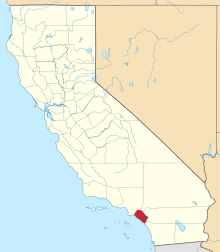
 Location of Aliso Viejo within Orange County, California. | ||
 Aliso Viejo, California Location in the United States | ||
| Coordinates: 33°34′30″N 117°43′32″W / 33.57500°N 117.72556°WCoordinates: 33°34′30″N 117°43′32″W / 33.57500°N 117.72556°W | ||
| Country |
| |
| State |
| |
| County | Orange | |
| Incorporated | July 1, 2001[2] | |
| Government | ||
| • Mayor | Mike Munzing[3] | |
| • Mayor Pro Tem | David Harrington[3] | |
| Area[4] | ||
| • Total | 7.472 sq mi (19.352 km2) | |
| • Land | 7.472 sq mi (19.352 km2) | |
| • Water | 0 sq mi (0 km2) 0% | |
| Elevation[5] | 410 ft (125 m) | |
| Population (April 1, 2010)[6] | ||
| • Total | 47,823 | |
| • Estimate (2013)[6] | 50,175 | |
| • Density | 6,400/sq mi (2,500/km2) | |
| Time zone | PST (UTC-8) | |
| • Summer (DST) | PDT (UTC-7) | |
| ZIP code | 92656, 92698 | |
| Area code(s) | 949 | |
| FIPS code | 06-00947 | |
| GNIS feature IDs | 252532, 2409683 | |
| Website |
www | |


Aliso Viejo is a city in the San Joaquin Hills of southern Orange County, California. It had a population of 47,823 as of the 2010 census, up from 40,166 as of the 2000 census. It became Orange County's 34th city on July 1, 2001, the only city in Orange County to be incorporated since 2000. It is bordered by the cities of Laguna Beach on the west and southwest, Laguna Hills on the east, Laguna Niguel on the southeast, and Laguna Woods on the north.
History
The planned community of Aliso Viejo's original 6,600 acres were once part of the 26,000-acre Moulton Ranch, owned by the Moulton family, who took title in the 1890s to land originally granted to Juan Avila by the Mexican government in 1842. Over the years, portions of the ranch were sold and became Leisure World, Laguna Hills and Laguna Niguel. In 1976, the Mission Viejo Company purchased the remaining 6,600 acres to create a new planned community – Aliso Viejo – with a master plan for 20,000 homes for a planned population of 50,000. The master plan was approved by the Orange County in 1979, and homes were first offered for sale in March 1982. Aliso Viejo's first family moved in that November. As part of the project, 2,600 acres were dedicated to Orange County as part of the Aliso and Wood Canyons Wilderness Park, and 800 additional acres were set aside for local parks, recreation, schools and community facilities. The Aliso Viejo Community Association (AVCA) was set up to manage the local parks and community open space. It was the first community-wide association of its kind in California and has the unique ability to provide a full-range of community services and facilities.[7]
Aliso Viejo was the first planned community in California to plan a balance between the projected resident work force and the number of projected jobs within its borders. Pacific Park, the centrally located 900-acre business park and town center, was expected to ultimately provide more than 22,000 jobs. Every home in Aliso Viejo was located about 1 1/2 miles from Pacific Park, to encourage live-and-work opportunities.[7]
Incorporation
Aliso Viejo had been an unincorporated community since 1979, and incorporated as a city in 2001 due to the efforts of the Aliso Viejo Cityhood 2000 Committee, which was responsible for introducing an initiative on the ballot for the 2001 special election. Voters passed the initiative with 93.3% in favor of incorporation.[8] Carmen Vali-Cave, the co-founder and president of the Committee, became the new city's first mayor.
The seal of the city of Aliso Viejo was adopted in 2001 at incorporation. The seal features several mountains, a boat, a tree, and several buildings. Also, the seal features the slogan "Since 2001", in celebration of the city's incorporation date.
Government
Aliso Viejo is a general law city with a council-manager system of government. Day-to-day operations are handled by a professional city manager overseen by a volunteer city council. The City Council of Aliso Viejo consists of five members serving staggered four-year terms. Each year, the Council votes for its next Mayor and Mayor pro tem. The current City Council consists of Mayor Mike Munzing, Mayor Pro Tem David Harrington, Council Members Ross Chun, William Phillips and Phillip Tsunoda.

State and federal representation
In the California State Legislature, Aliso Viejo is in the 36th Senate District, represented by Republican Patricia Bates, and in the 73rd Assembly District, represented by Republican Bill Brough.[9]
In the United States House of Representatives, Aliso Viejo is in California's 48th congressional district, represented by Republican Dana Rohrabacher.[10]
Geography
Aliso Viejo is located at 33°34′30″N 117°43′32″W / 33.57500°N 117.72556°W (33.575096, -117.725431)[11] in the San Joaquin Hills of Orange County. According to the Census Bureau, the city has a total area of 7.5 square miles (19 km2), all of which is land. Aliso Viejo is one of several cities bordering Aliso and Wood Canyons Regional Park. Aliso Creek forms part of the city's boundary with Laguna Niguel to the south, and Wood Canyon Creek forms part of the city's western boundary. Much of the city rests on the east slope of the San Joaquin Hills, which are a coastal mountain range extending for about 15 miles (24 km) along the Pacific coast.
Demographics
| Historical population | |||
|---|---|---|---|
| Census | Pop. | %± | |
| 1990 | 7,612 | — | |
| 2000 | 40,166 | 427.7% | |
| 2010 | 47,823 | 19.1% | |
| Est. 2015 | 50,195 | [12] | 5.0% |
2010
The 2010 United States Census[14] reported that Aliso Viejo had a population of 47,823. The population density was 6,400.4 people per square mile (2,471.2/km²). The racial makeup of Aliso Viejo was 34,437 (89.0%) White (77.8% Non-Hispanic White),[15] 967 (2.0%) African American, 151 (0.1%) Native American, 6,996 (14.6%) Asian, 89 (0.2%) Pacific Islander, 2,446 (5.1%) from other races, and 2,737 (5.7%) from two or more races. Hispanic or Latino of any race were 8,164 persons (9.1%).
The Census reported that 47,354 people (99.0% of the population) lived in households, 450 (0.9%) lived in non-institutionalized group quarters, and 19 (0%) were institutionalized.
There were 18,204 households, out of which 7,095 (39.0%) had children under the age of 18 living in them, 9,358 (51.4%) were opposite-sex married couples living together, 1,966 (10.8%) had a female householder with no husband present, 791 (4.3%) had a male householder with no wife present. There were 987 (5.4%) unmarried opposite-sex partnerships, and 206 (1.1%) same-sex married couples or partnerships. 4,416 households (24.3%) were made up of individuals and 638 (3.5%) had someone living alone who was 65 years of age or older. The average household size was 2.60. There were 12,115 families (66.6% of all households); the average family size was 3.16.
The population was spread out with 12,395 people (25.9%) under the age of 18, 3,739 people (7.8%) aged 18 to 24, 17,138 people (35.8%) aged 25 to 44, 12,003 people (25.1%) aged 45 to 64, and 2,548 people (5.3%) who were 65 years of age or older. The median age was 35.1 years. For every 100 females there were 92.8 males. For every 100 females age 18 and over, there were 89.2 males.
There were 18,867 housing units at an average density of 2,525.1 per square mile (974.9/km²), of which 11,049 (60.7%) were owner-occupied, and 7,155 (39.3%) were occupied by renters. The homeowner vacancy rate was 1.2%; the rental vacancy rate was 3.6%. 29,819 people (62.4% of the population) lived in owner-occupied housing units and 17,535 people (36.7%) lived in rental housing units.
2000
As of the census[16] of 2000, there were 40,166 people, 16,147 households, and 10,689 families residing in what was, at the time, a Census Designated Place (CDP). The population density was 3,927.7 inhabitants per square mile (1,516.0/km²). There were 16,608 housing units at an average density of 1,624.0 per square mile (626.8/km²). The racial makeup of the CDP was 78.16% White, 10.99% Asian, 2.06% Black or African American, 0.39% Native American, 0.22% Pacific Islander, 3.51% from other races, and 4.66% from two or more races. 11.65% of the population were Hispanic or Latino of any race.
There were 16,147 households out of which 37.7% had children under the age of 18 living with them, 52.7% were married couples living together, 10.2% had a female householder with no husband present, and 33.8% were non-families. 23.8% of all households were made up of individuals and 1.8% had someone living alone who was 65 years of age or older. The average household size was 2.49 and the average family size was 3.01.
The population was distributed with 26.1% under the age of 18, 5.5% from 18 to 24, 48.8% from 25 to 44, 16.3% from 45 to 64, and 3.4% who were 65 years of age or older. The median age was 33 years. For every 100 females there were 93.4 males. For every 100 females age 18 and over, there were 91.4 males.
According to a 2007 estimate, the median income for a household in the CDP was $92,280, and the median income for a family was $99,853.[17] Males had a median income of $61,316 versus $44,190 for females. The per capita income for the CDP was $35,244. About 2.3% of families and 2.8% of the population were below the poverty line, including 3.5% of those under age 18 and 2.8% of those age 65 or over.
Economy

Companies located in Aliso Viejo include:
- 3tera, a cloud computing software vendor
- AND1 a shoe and apparel company
- Buy.com, an online retailer
- Centon Electronics, Inc., a computer Memory manufacturer as well as flash based storage devices
- Fluor, an international construction contractor for petrochemical, infrastructure, and environmental projects, headquartered in Aliso Viejo until it was relocated to the Dallas-Fort Worth Metroplex suburb of Irving, Texas in March 2006. Some divisions still reside in Aliso Viejo.
- Katie Wagner Social Media, a full service Digital Marketing Agency
- Ketel One, a vodka company
- Marie Callender's, a restaurant chain
- Microsoft's office after the purchase of DATAllegro
- Nimbus Data, a network storage systems and software company
- Pacific Life, an insurance company
- QLogic, a network storage manufacturer
- Dell Software (formerly Quest Software), a software manufacturer
- Smith Micro Software, a software developer
- Tamiya America, US subsidiary of the manufacturer of model cars Tamiya Corporation, headquartered in Aliso Viejo until it was relocated to Irvine, CA.
- UST Global, an IT services and business process outsourcing company
- USWeb, an Internet marketing company
- Microsemi Corporation, a semiconductor company
- Gaikai, a cloud-based gaming service
- Carbine Studios, a video game developer, partnered with NCSOFT
- Metagenics, a medical manufacturing company
Top employers
According to the City's 2011 Comprehensive Annual Financial Report,[18] the top employers in the city are:
| # | Employer | # of employees |
|---|---|---|
| 1 | United Parcel Service | 1,000 |
| 2 | Pacific Life | 811 |
| 3 | Capistrano Unified School District | 679 |
| 4 | Fluor | 630 |
| 5 | Quest Software | 600 |
| 6 | QLogic | 490 |
| 7 | Renaissance ClubSport Aliso Viejo | 259 |
| 8 | Pepsi Beverages Company | 215 |
| 9 | Smith Micro Software | 200 |
| 10 | Merit Property Management | 199 |
| 11 | Buy.com | 185 |
| 12 | Lennar | 175 |
| 13 | Target | 170 |
| 14 | Bausch & Lomb | 160 |
| 15 | Ambry Genetics | 777 |
| 16 | The Covington | 153 |
| 17 | LenSx Laser | 150 |
| 18 | Lowe's | 130 |
Points of interest
- Aliso Viejo Town Center features a movie theater, a wide variety of casual dining restaurants, PetSmart, a Barnes & Noble, a Ralphs supermarket, as well as other shops. It also includes Grand Park which is a center for community concerts and events.
- The Aliso Viejo Library, a branch of the Orange County Public Library system, opened on January 31, 1998.[19]
- Aliso Viejo Golf Course was designed by Nicklaus Design in 1999 and became the Aliso Viejo Country Club with a redesign in 2005.[20]
- Soka University was dedicated on May 3, 2001 with a 103-acre campus and 18 buildings, a $250 million (land and construction) project.[21]
- Soka Performing Arts Center, a 1000-seat concert hall with acoustics designed by Yasuhisa Toyota (who also designed Walt Disney Concert Hall,) opened in September 2011.[22]
- Renaissance ClubSport is a $65 million property which opened in July 2008. It is Marriott's second hotel and fitness resort created in conjunction with Leisure Sports, Inc. (ClubSport) to fulfill the growing demand by local residents and hotel guests for a healthier lifestyle.
Sports teams
- The Orange County Gladiators are an American Basketball Association (ABA) expansion team starting in November 2007. They will play their home games at Aliso Niguel High School.
- Kyla Ross a member of the women's artistic gymnastics team that won the gold medal at the 2012 Summer Games in London, currently resides in this city.
Controversy
"Dihydrogen monoxide" incident
Aliso Viejo city officials famously came close to banning polystyrene cups in 2004 after hearing that "dihydrogen monoxide" was used in their production, neglecting the fact that this substance is actually plain water. A paralegal working for the city found the dhmo.org website and subsequently proposed the ban.[23]
William Freund murder-suicide
In October 2005, the city gained national media attention once again when 19-year-old resident William Freund donned a cape and mask and murdered two of his neighbors, 22-year-old Christina Smith and her father Vernon, before killing himself. Freund suffered from Asperger Syndrome.[24] Freund was an alumnus of Aliso Viejo's only high school, Aliso Niguel High School. On November 17, 2006, the family of the two victims sued Freund's parents for "wrongful death and emotional distress."[25]
School dance ban
In September 2006, Charles Salter, the principal of Aliso Niguel High School, Aliso Viejo's high school, gained widespread media attention when he banned all school dances until further notice. Salter came under fire for his decision. The decision was based on the school's "Welcome Back Dance", at which several students arrived intoxicated, while others engaged in "freak dancing", which Salter views as inappropriate at a school dance. At the end of the month, Salter stood his ground and cancelled the school's annual Homecoming Dance, which gained both Salter and the school notoriety.[26] A story on the school was featured on the national television program, Geraldo at Large and the BBC also covered the dance ban. In late November, it was announced that the dances would return to the school, but under new rules that banned "freak dancing."[27]
Mail distribution center
In 2008-early 2009, Aliso Viejo residents were protesting the United States Postal Service's plan to build a large mail distribution facility. The proposed facility would have up to 500 employees and USPS trucks traveling over residential streets 24-hours per day. Residents were concerned about damage to city streets, traffic and the trucks travelling through city neighborhoods. On March 9, 2009, the USPS announced that it would not move forward with plans to build the distribution facility due to the economic outlook at the time.[28]
Emergency services
Fire protection in Aliso Viejo is provided by the Orange County Fire Authority with ambulance service by Care Ambulance. Law enforcement is provided by the Orange County Sheriff's Department.


Education
The city is served by Capistrano Unified School District, which includes these schools:
Elementary
- Canyon Vista Elementary School
- Don Juan Avila Elementary School
- Oak Grove Elementary School
- Wood Canyon Elementary School
Middle school
High school
Aliso Viejo also has private schools, including VanDamme Academy, St. Mary and All Angels School, Aliso Viejo Christian School, and a university, Soka University of America.
Notable natives and residents
- Farzad Bonyadi, professional poker player
- Ryan Coiner, Major League Soccer player for the Columbus Crew
- Ryan Getzlaf, center for the Anaheim Ducks
- Jim Gilchrist, politician and founder of the Minuteman Project
- Kenneth Kizer, CEO and former Secretary of Health in the United States Department of Veterans Affairs
- Ivan Koumaev, contestant on the reality series So You Think You Can Dance
- Marc Maiffret, computer security expert/computer hacker
- McKayla Maroney, gymnast, 2012 Olympic champion
- Kyla Ross, gymnast, 2012 Olympic champion
- Toni Turner, author
- Alisa Valdez-Rodriguez, author
- Ashley Wagner, figure skater, 3-time U.S. champion
- Alicia Leigh Willis, actress who plays Courtney Matthews on General Hospital
See also
 Greater Los Angeles portal
References
- ↑ "About" on the City of Aliso Viejo website
- ↑ "California Cities by Incorporation Date". California Association of Local Agency Formation Commissions. Archived from the original (Word) on November 3, 2014. Retrieved August 25, 2014.
- 1 2 "City Council - General Information". City of Aliso Viejo. Retrieved January 28, 2015.
- ↑ "2010 Census U.S. Gazetteer Files – Places – California". United States Census Bureau.
- ↑ "Aliso Viejo". Geographic Names Information System. United States Geological Survey. Retrieved February 23, 2015.
- 1 2 "Aliso Viejo (city) QuickFacts". United States Census Bureau. Retrieved March 18, 2015.
- 1 2 "Aliso Viejo ... for today and tomorrow" Mission Viejo Company
- ↑ County Government website
- ↑ "Statewide Database". UC Regents. Retrieved December 8, 2014.
- ↑ "California's 48th Congressional District - Representatives & District Map". Civic Impulse, LLC.
- ↑ "US Gazetteer files: 2010, 2000, and 1990". United States Census Bureau. 2011-02-12. Retrieved 2011-04-23.
- ↑ "Annual Estimates of the Resident Population for Incorporated Places: April 1, 2010 to July 1, 2015". Retrieved July 2, 2016.
- ↑ "Census of Population and Housing". Census.gov. Archived from the original on May 11, 2015. Retrieved June 4, 2015.
- ↑ "2010 Census Interactive Population Search: CA - Aliso Viejo city". U.S. Census Bureau. Retrieved July 12, 2014.
- ↑ "State & County QuickFacts: Aliso Viejo (city), California".
- ↑ "American FactFinder". United States Census Bureau. Archived from the original on September 11, 2013. Retrieved 2008-01-31.
- ↑ American FactFinder. Factfinder.census.gov. Retrieved on 2013-09-19.
- ↑ City of Aliso Viejo CAFR
- ↑ http://articles.latimes.com/1998/jan/31/local/me-13962
- ↑ http://www.clubcorp.com/Clubs/Aliso-Viejo-Country-Club/Our-Story/General-Information/History
- ↑ http://www.soka.edu/about_soka/a_proud_heritage.aspx
- ↑ http://www.performingarts.soka.edu/about/default.aspx
- ↑ "Local officials nearly fall for H2O hoax." MSNBC. March 15, 2004. Retrieved on September 4, 2008.
- ↑ "Killer Sought Solace Online". LA Times. November 1, 2005. Retrieved July 23, 2014.
- ↑ Tran, Mai. "Relatives sue over shotgun slayings in Aliso Viejo." Los Angeles Times. November 18, 2006. Retrieved on March 18, 2007.
- ↑ Hernandez, Salvador. "Homecoming dance gets boot." The Orange County Register. September 29, 2006. Retrieved on March 18, 2007.
- ↑ Hernandez, Salvador. "School dances return under new rules." The Orange County Register. November 29, 2006. Retrieved on March 18, 2007.
- ↑ Evezich, Lois (March 3, 2009). "Postal Service Facility a No-Go". The Orange County Register.
External links
| Wikimedia Commons has media related to Aliso Viejo, California. |
 Aliso Viejo travel guide from Wikivoyage
- Official website
- Around Aliso Viejo Webshow
- OrangeCounty.net City Guide
- Orange County Public Library, Aliso Viejo Branch