Rancho Santa Margarita, California
| Rancho Santa Margarita, California | |||
|---|---|---|---|
| City | |||
|
Rancho Santa Margarita | |||
| |||
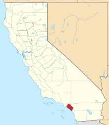
 Location of Rancho Santa Margarita within Orange County, California. | |||
 Rancho Santa Margarita, California Location in the United States | |||
| Coordinates: 33°38′29″N 117°35′40″W / 33.64139°N 117.59444°WCoordinates: 33°38′29″N 117°35′40″W / 33.64139°N 117.59444°W | |||
| Country |
| ||
| State |
| ||
| County | Orange | ||
| Incorporated | January 1, 2000[1] | ||
| Government | |||
| • Mayor | L. Anthony Beall[2] | ||
| Area[3] | |||
| • Total | 12.992 sq mi (33.651 km2) | ||
| • Land | 12.957 sq mi (33.560 km2) | ||
| • Water | 0.035 sq mi (0.091 km2) 0.27% | ||
| Elevation[4] | 925 ft (282 m) | ||
| Population (April 1, 2010)[5] | |||
| • Total | 47,853 | ||
| • Estimate (2013)[5] | 49,228 | ||
| • Density | 3,700/sq mi (1,400/km2) | ||
| Time zone | Pacific (UTC-8) | ||
| • Summer (DST) | PDT (UTC-7) | ||
| ZIP codes | 92688, 92679 | ||
| Area code | 949 | ||
| FIPS code | 06-59587 | ||
| GNIS feature IDs | 1867054, 2411517 | ||
| Website |
cityofrsm | ||


Rancho Santa Margarita is a city in Orange County, California, United States. One of Orange County's youngest cities, Rancho Santa Margarita is a master planned community set upon rolling hills. The population was 47,853 at the 2010 census, up from 47,214 at the 2000 census.
Although it is named for Rancho Santa Margarita y Las Flores, which was in San Diego County, the city limits fall within the borders of Rancho Mission Viejo. At 22 characters long, it is the longest city name in California.
History
The city seal has the brands of Rancho Mission Viejo and Rancho Santa Margarita and Las Flores on the border, with artwork containing Santiago Peak in the background. The tower in the foreground symbolizes the Rancho Santa Margarita Lake Tower.
Hughes Aircraft Company's Microelectronic Systems Division moved to Rancho Santa Margarita in May 1988 from Irvine. In August 1992 the Hughes plant closed its facilities and moved the division to Carlsbad, California due to budget constraints in the aerospace industry.
Rolling Hills Estates had the longest city name in California with 19 letters until January 1, 2000, when the title was ceded to Rancho Santa Margarita (20 letters) upon the latter's incorporation.
Where schools, shopping centers and residential neighborhoods now stand, Native Americans once lived. On July 23, 1769, they were visited by a Spanish expedition under Captain Gaspar de Portola, who camped near the site of Tijeras Creek Golf Course in Rancho Santa Margarita.
On July 24, the expedition headed inland to avoid the many streams and swamps in the area. They found a large plateau area and camped that night on its western edge by a canyon, which the Franciscans named San Francisco Solano. This was on the eastern side of Trabuco Creek about three miles downstream from the present site of Trabuco Oaks.
While camped here on July 24–25, one of the soldiers lost his trabuco, or musket, a most valuable possession to any soldier. To mark this loss, the stream was named Trabuco. The name has been associated with the mesa, the canyon, and the entire area ever since. The Spaniards founded Mission San Juan Capistrano in 1776, and ruled the region until 1821, when California became part of Mexico.
The Mexican governors carved the area around the mission into three large ranchos: Rancho Trabuco, Rancho Mission Viejo, and Rancho Santa Margarita. James L. Flood and his partner Jerome O’Neill purchased the combined ranchos in 1882. The huge estate was run as a working ranch into the 1920s. In 1940, the ranch was divided, with the Flood family taking the lower portion, in today's San Diego County, with the upper portion retained by the O'Neill family. In 1942, the Navy annexed the Flood family’s portion of the ranch for use as Camp Joseph H. Pendleton.
In 1948, the O'Neill family donated 278 acres of canyon bottom land to the County of Orange for park purposes. The O'Neill family donated an additional 120 acres of parkland in 1963, the same year they founded the Mission Viejo Company and drew up plans for a master-planned community of the same name.
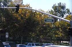
By the 1960s, a rural cluster of homes had been present in Trabuco Canyon for decades. The area's first tract developed homes didn't arrive until late in the decade in what would become Coto de Caza, which started out as a hunting and fishing resort. The area remained fairly remote until 1986, when the first homes in the new master planned community of Rancho Santa Margarita were sold. The economic boom of the 1980s also fueled home construction in nearby Dove Canyon, Robinson Ranch, Wagon Wheel and a handful of smaller developments. The area became better linked to the rest of the county in 1992, when extensions of Oso, Antonio and Alicia Parkways were completed.
In 1989, the people of the community of Rancho Santa Margarita established a Community Civic Association (CCA) for the purpose of providing a political voice for the community. The CCA, later known as the Rancho Margarita Civic Association (and still later as the Civic Council), briefly explored self-governance, but it was in 1995 that the RSM Cityhood Committee, a separate community organization, began the official drive for cityhood. Rancho Santa Margarita was planned to be an “Urban Village”, offering the best of two worlds: all of the elements and advantages of a small city plus the quality of life of a small village.
In November 1999, area voters opted to incorporate the Rancho Santa Margarita Planned Community and the neighboring Robinson Ranch, Dove Canyon, Rancho Cielo, Trabuco Highlands and Walden Communities. The newly formed City of Rancho Santa Margarita incorporated on January 1, 2000, and became the 33rd city in the County of Orange.
The City is a general law city and operates under the council-manager form of government. Rancho Santa Margarita is a contract city. Police services are provided through contract with the Orange County Sheriff. Fire Protection services are provided through the Orange County Fire Authority.
Since its incorporation in 2000, Rancho Santa Margarita has repeatedly been rated as one of the safest cities in California and the nation.
Geography
Rancho Santa Margarita is located at 33°38′29″N 117°35′40″W / 33.64139°N 117.59444°W (33.641518, -117.594524).[6] It occupies much of a high plateau known as Plano Trabuco.
According to the United States Census Bureau, the city has a total area of 13.0 square miles (34 km2). 13.0 square miles (34 km2) of it is land and 0.04 square miles (0.10 km2) of it (0.27%) is water.
Rancho Santa Margarita is bordered by the city of Mission Viejo on the west, the census-designated Coto de Caza and Las Flores on the south, Trabuco Canyon on the north, and the Cleveland National Forest on the east.
Major homeowners associations and communities

The majority of the neighborhoods in RSM are maintained by larger homeowners associations including SAMLARC, Melinda Heights, town center, Dove Canyon, Rancho Cielo, Robinson Ranch, and Trabuco Highlands. SAMLARC, Dove Canyon, Trabuco Highlands, Robinson Ranch, and Rancho Cielo were all established before Rancho Santa Margarita was an incorporated community. East of Plano Trabuco Road is designated with a Trabuco Canyon (92679) zip code even though the area falls within the City of Rancho Santa Margarita boundary.[7]
SAMLARC
The Rancho Santa Margarita Landscape and Recreation Corporation, or SAMLARC, is often referred to as the master association in Rancho Santa Margarita because other smaller sub associations fall within its membership and it encompasses the original footprint of the master planned community of Rancho Santa Margarita. SAMLARC comprises roughly 13,000 units and maintains most streetscapes, medians, parks and trails within the community. In total, SAMLARC runs and maintains 13 parks, 4 pools, a lagoon, a lake, and numerous trails within the community. One of SAMLARC's most popular parks, Central Park located next to City Hall, contains a large amphitheater where a number of community events are held each year. Central Park is also home to an arena soccer rink that was converted from a roller hockey rink. SAMLARC also maintains a popular skate and dog park that are located within SAMLARC's Canada Vista Park.[8]
Dove Canyon
Dove Canyon is a private residential community located in eastern Rancho Santa Margarita. It is a small enclave of approximately 1,200 homes and 5,000 residents. Included within the guard-gated entry is a Jack Nicklaus signature golf club, pool, tennis courts, a small child's park, a wide field, a shopping center (just outside the entry), and a reservoir. The majority of its residents are upper middle class residents of Orange County, and all of the homes in Dove Canyon are single-family residences. It is located in the Southeasternmost foothills of Orange County. Major roads include Dove Canyon/Bell Canyon and Sycamore Canyon. A horse trail starts at the waterfalls outside of the community and continues until the end of Sycamore Canyon. From there, hikers, horse riders, bikers, etc. can continue into Dove Canyon's neighboring community, Coto de Caza.
Robinson Ranch
Robinson Ranch is a mid-sized residential community located northeastern Rancho Santa Margarita south of Trabuco Canyon. It is one of the older communities in Rancho Santa Margarita. It has several condominium areas closer to Plano Trabuco Road and two large parks. Major Roads include Robinson Ranch and Shadow Rock. Like Dove Canyon and Rancho Cielo it is assigned with a Trabuco Canyon zip code even though the areas were annexed into Rancho Santa Margarita when the city incorporated in 2000. The street at the bottom of the hill is the entrance into O'Neill Regional Park.
Rancho Cielo
Rancho Cielo is a smaller residential community located in eastern Rancho Santa Margarita. It includes gated entry with security guard. It is near the intersection of Plano Trabuco Road and Dove Canyon Drive. All of the homes are all single family residences and the majority of its residents are upper-middle class. Major Roads include Rancho Cielo and Camino Del Cielo.
Climate
Rancho Santa Margarita, like most of coastal southern California, generally has a Mediterranean climate. The name derives from its similarity to the climate of areas along the Mediterranean Sea. Summers are hot, and winters are mild, rarely falling below freezing. Precipitation in Rancho Santa Margarita occurs predominantly during the winter months. The average January temperature in Rancho Santa Margarita is 60 °F (16 °C), while the average August temperature is 80 °F (27 °C).
Economy
Top employers
According to the City's 2010 Comprehensive Annual Financial Report,[9] the top 11 employers in the city are:
| # | Employer | # of employees |
|---|---|---|
| 1 | Applied Medical | 2500+ (est)ǂ |
| 2 | O'Connell Landscape Maintenance | 980 |
| 3 | Saddleback Valley Unified School District | 606 |
| 4 | Lucas & Mercier Construction | 553 |
| 5 | Control Components Inc. | 370 |
| 6 | Target | 247 |
| 7 | Car Sound Exhaust System | 207 |
| 8 | Capistrano Unified School District | 210 |
| 9 | Santa Margarita Catholic High School | 200 |
| 10 | Professional Association of Diving Instructors | 200 |
ǂ As of June 2015
Demographics
| Historical population | |||
|---|---|---|---|
| Census | Pop. | %± | |
| 1990 | 11,390 | — | |
| 2000 | 47,214 | 314.5% | |
| 2010 | 47,853 | 1.4% | |
| Est. 2015 | 49,324 | [10] | 3.1% |

2010
The 2010 United States Census[12] reported that Rancho Santa Margarita had a population of 47,853. The population density was 3,683.1 people per square mile (1,422.0/km²). The racial makeup of Rancho Santa Margarita was 37,421 (78.2%) White (67.0% Non-Hispanic White),[5] 887 (1.9%) African American, 182 (0.4%) Native American, 4,350 (9.1%) Asian, 102 (0.2%) Pacific Islander, 2,674 (5.6%) from other races, and 2,237 (4.7%) from two or more races. Hispanic or Latino of any race were 8,902 persons (18.6%).
31.8% of the population possessed a bachelor's degree, with 16.4% possessing a Graduate or Professional Degree. The educational attainment level in Rancho Santa Margarita significantly exceeds the averages throughout the rest of California.
The Census reported that 47,851 people (100% of the population) lived in households, 2 (0%) lived in non-institutionalized group quarters, and 0 (0%) were institutionalized.
There were 16,665 households, out of which 7,699 (46.2%) had children under the age of 18 living in them, 10,144 (60.9%) were opposite-sex married couples living together, 1,703 (10.2%) had a female householder with no husband present, 700 (4.2%) had a male householder with no wife present. There were 747 (4.5%) unmarried opposite-sex partnerships, and 103 (0.6%) same-sex married couples or partnerships. 3,199 households (19.2%) were made up of individuals and 761 (4.6%) had someone living alone who was 65 years of age or older. The average household size was 2.87. There were 12,547 families (75.3% of all households); the average family size was 3.33.
The population was spread out with 13,879 people (29.0%) under the age of 18, 3,793 people (7.9%) aged 18 to 24, 13,706 people (28.6%) aged 25 to 44, 13,764 people (28.8%) aged 45 to 64, and 2,711 people (5.7%) who were 65 years of age or older. The median age was 36.0 years. For every 100 females there were 95.6 males. For every 100 females age 18 and over, there were 92.1 males.
There were 17,260 housing units at an average density of 1,328.4 per square mile (512.9/km²), of which 11,906 (71.4%) were owner-occupied, and 4,759 (28.6%) were occupied by renters. The homeowner vacancy rate was 1.2%; the rental vacancy rate was 5.6%. 35,737 people (74.7% of the population) lived in owner-occupied housing units and 12,114 people (25.3%) lived in rental housing units.
During 2009–2013, Rancho Santa Margarita had a median household income of $104,113, with 3.9% of the population living below the federal poverty line.[5]
Education
The city is served by Saddleback Valley Unified School District and the Capistrano Unified School District.
- Students in SVUSD boundaries attend Trabuco Hills High School or Mission Viejo High School, both outside of Rancho Santa Margarita in the city of Mission Viejo. Students in CUSD boundaries attend Tesoro High School located in the Las Flores neighborhood.
- RSM Intermediate School (SVUSD) and Las Flores Middle School (CUSD) serve the city.
- Public Elementary schools include Cielo Vista, Trabuco Mesa, Robinson Ranch, Arroyo Vista, Melinda Heights, and Tijeras Creek.
- Private Elementary and Middle Schools include St. John's Episcopal Day School, Serra Catholic, and Mission Hills Christian School.
- Santa Margarita Catholic High School is a private Roman Catholic high school associated with the Catholic Diocese of Orange, and headed by Principal Ray Dunne. SMCHS is located in Rancho Santa Margarita.
Popular culture
Television
The television series The Real Housewives of Orange County, although based in Coto De Caza, is mainly filmed in Rancho Santa Margarita where many of the housewives do business, shopping, commuting, and dining.[13]
The city's name often creates confusion: people in the Las Flores, Dove Canyon, Rancho Cielo, or Robinson Ranch neighborhoods, for example, can receive mail addressed to them at Rancho Santa Margarita, Dove Canyon, Coto de Caza, Robinson Ranch or Trabuco Canyon. This is due to them all having the same ZIP code: 92688.
A map of Orange County seen in season four of Arrested Development places the fictional Bluth Company-developed community of Sudden Valley northeast of Mission Viejo and Las Flores, in the approximate location of Rancho Santa Margarita.
Notable people
- R.J. Adams, acting coach, radio personality, producer
- Jonathon Blum, ice hockey player
- Rod Carew, baseball player
- Martin Dugard, author
- Faith Evans, singer
- Jim Everett, American football player
- Joy Fawcett, Olympic gold medalist[14]
- Bobby Grich, baseball player
- Chavo Guerrero, professional wrestler[15]
- Carson Palmer, American football player; attended Santa Margarita Catholic High School[16]
- Brian Perk, soccer player
- Teemu Selänne, ice hockey player[17]
- Klay Thompson, basketball player; attended Santa Margarita Catholic High School[18]
- Gavin Escobar, American football player
- Rick Warren, pastor of Saddleback Church
- Warren G, rapper and producer[19]
References
- ↑ "California Cities by Incorporation Date" (Word). California Association of Local Agency Formation Commissions. Retrieved August 25, 2014.
- ↑ "Mayor and City Council". Rancho Santa Margarita. Retrieved December 15, 2015.
- ↑ "2010 Census U.S. Gazetteer Files – Places – California". United States Census Bureau.
- ↑ "City of Rancho Santa Margarita". Geographic Names Information System. United States Geological Survey. Retrieved February 25, 2015.
- 1 2 3 4 "Rancho Santa Margarita (city) QuickFacts". United States Census Bureau. Retrieved January 28, 2015.
- ↑ "US Gazetteer files: 2010, 2000, and 1990". United States Census Bureau. 2011-02-12. Retrieved 2011-04-23.
- ↑ City Zoning Map
- ↑ Official SAMLARC Website
- ↑ City of Rancho Santa Margarita CAFR
- ↑ "Annual Estimates of the Resident Population for Incorporated Places: April 1, 2010 to July 1, 2015". Retrieved July 2, 2016.
- ↑ "Census of Population and Housing". Census.gov. Retrieved June 4, 2015.
- ↑ "2010 Census Interactive Population Search: CA - Rancho Santa Margarita city". U.S. Census Bureau. Retrieved July 12, 2014.
- ↑ BRAVOtv.com: The Real Housewives of Orange County: Season 3 (Home)
- ↑ Perkes, Courtney (2008-07-23). "Ex-Olympian battles rheumatoid arthritis". The Orange County Register. pp. Life, etc. 2.
- ↑ https://imgur.com/a/af8VZ
- ↑ "Carson Palmer, QB for the Arizona Cardinals". NFL.com. Retrieved November 4, 2014.
- ↑ "Teemu Selänne Youth Sports Foundation". Retrieved November 4, 2014.
- ↑ "Klay Thompson Player Profile, Golden State Warriors". RealGM Basketball. Retrieved November 4, 2014.
- ↑ http://www.ocweekly.com/1999-11-25/features/not-angry-no-more/
External links
| Wikimedia Commons has media related to Rancho Santa Margarita, California. |