Laguna Niguel, California
| Laguna Niguel, California | ||
|---|---|---|
| City | ||
| City of Laguna Niguel | ||
|
Suburban homes in Laguna Niguel, 2004. | ||
| ||
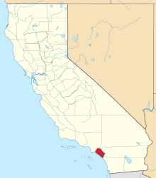
 Laguna Niguel, California  Laguna Niguel, California Location in the United States | ||
| Coordinates: 33°31′55″N 117°42′9″W / 33.53194°N 117.70250°WCoordinates: 33°31′55″N 117°42′9″W / 33.53194°N 117.70250°W | ||
| Country | United States | |
| State | California | |
| County | Orange | |
| Incorporated | December 1, 1989[1] | |
| Government | ||
| • Mayor[2] | Laurie Davies | |
| Area[3] | ||
| • Total | 14.885 sq mi (38.551 km2) | |
| • Land | 14.833 sq mi (38.418 km2) | |
| • Water | 0.052 sq mi (0.134 km2) 0.35% | |
| Elevation[4] | 400 ft (122 m) | |
| Population (April 1, 2010)[5] | ||
| • Total | 62,979 | |
| • Estimate (2015)[5] | 65,806 | |
| • Density | 4,200/sq mi (1,600/km2) | |
| Time zone | Pacific (UTC-8) | |
| • Summer (DST) | PDT (UTC-7) | |
| ZIP codes | 92607, 92677 | |
| Area code | 949 | |
| FIPS code | 06-39248 | |
| GNIS feature IDs | 1660875, 2411597 | |
| Website |
ci | |


Laguna Niguel is a suburban city in Orange County, California in the United States. The name Laguna Niguel is derived from the words "Laguna" (Spanish for "lagoon") and "Niguili" (the name of a Native American village once located near Aliso Creek).[6] As of the 2010 census, the population was 62,979. Laguna Niguel is located in the San Joaquin Hills in the southeastern corner of Orange County, close to the Pacific Ocean, and borders the cities of Aliso Viejo, Dana Point, Laguna Beach, Laguna Hills, Mission Viejo and San Juan Capistrano.
Laguna Niguel has its origins in the Rancho Niguel Mexican land grant, which was acquired in 1959 by the Laguna Niguel Corporation to develop one of California's first master-planned communities. As a predominantly residential city, Laguna Niguel serves as a bedroom community for the job centers of northern and central Orange County. Laguna Niguel is a relatively affluent city, with median household income 31 percent above the Orange County average[7] and nearly double the U.S. average.[8] It is known for its mild coastal climate, low crime rate[9] and its numerous parks and public trails.[10]
History
Early inhabitants and settlers
The first recorded inhabitants of the Laguna Niguel area were the Acjachemem Native Americans, who may have had a village called "Niguili" near the confluence of Aliso Creek and Sulphur Creek.[11] Aliso Creek marked the boundary between the Acjachemem and Tongva people. In the 1700s, during the Spanish colonization of the Americas, Spanish missionaries established the nearby Mission San Juan Capistrano to convert the Acjachemem (called the Juañeno by the Spanish) to Christianity. The Mission lands, which included the present-day boundaries of Laguna Niguel, were divided into private land grants in 1821 upon Mexico's independence from Spain.
In 1842, the 13,316-acre (5,389 ha) Rancho Niguel was granted to Juan Avila; he retained ownership of the land through the Mexican-American War (when California became part of the United States) until 1865, when a severe drought forced him into bankruptcy. In 1895 Lewis Moulton and Jean Pierre Daguerre bought the Rancho Niguel and other portions of the surrounding area from farmers who were struggling due to persistent drought conditions. The Moulton Company was established to oversee 19,000 acres (7,700 ha) of local land which was used, mainly for orchards and sheep ranching, well into the mid-20th century.[11] In 1951 the land was divided between the Moulton and Daguerre families, the latter inheriting 8,056 acres (3,260 ha) in the future location of Laguna Niguel. In 1954 the Daguerres sold 7,200 acres (2,900 ha) to the Shumaker Group and 856 acres (346 ha) of oceanfront to George Capron, a former Major League Baseball player who established the Capron Ranch.[12]
Laguna Niguel Corporation

The completion of Interstate 5 in 1959 enabled easy access to job centers in Los Angeles County, creating a boom in the Orange County housing market. In 1959, Cabot, Cabot & Forbes and Paine Webber partnered to form the Laguna Niguel Corporation, which purchased the Daguerre land to develop one of California's first master planned communities. The initial 7,100-acre (2,900 ha) town plan was created by Viennese architect Victor Gruen and expanded beginning in 1971 by AVCO Community Developers after they acquired the Laguna Niguel Corporation.[11][12][13] The name of the city was created from "Laguna", a reference to the tidal lagoon that once formed at the mouth of Aliso Creek, and the name of the Acjachemem village Niguili that once occupied the area. As the city would be developed in stages, ranchers and farmers signed annual leases with the Laguna Niguel Corporation to use the land until the planned communities were built.
In contrast to a traditional bedroom community, Laguna Niguel was designed so that "families should have most of their economic needs and their social and cultural interests met by facilities within the community".[12] The plan was also notable for its emphasis on parks and open space – comprising nearly a third of the land to be developed. The Laguna Niguel Corporation went public in April 1959 and raised an initial $8.2 million from investors. In 1962 the first tracts of Monarch Bay and Niguel Terrace were completed, consisting of 565 homes.[12] In 1960, the Moulton Niguel Water District (which today serves all of Laguna Niguel) was established by a conglomerate of ranchers, to import water from the Colorado River Aqueduct as the area lacked a sufficient natural water supply.[14] In 1964, Crown Valley Parkway was completed from I-5 to the Pacific Coast Highway, facilitating transport through the growing city.[12] By 1965 the population of Laguna Niguel reached 1,000.[15]

The Laguna Niguel Homeowner's Association was formed in 1966 as an advisory to the Orange County Board of Supervisors (which governed the as-yet unincorporated city). In 1973 Laguna Niguel Regional Park opened to the public. The Chet Holifield Federal Building (a local landmark popularly known as the "Ziggurat"), designed by William L. Pereira, was constructed for Rockwell International and was meant to bring 7,000 jobs to the area. After the end of the Vietnam War, Rockwell reportedly lost a defense contract with the federal government and the building was left unoccupied. It was eventually traded to the US General Services Administration in exchange for industrial facilities elsewhere.[16]
The Ziggurat, which was completed in 1971 well before the development of residential communities in the area, is one of Laguna Niguel's most noticeable landmarks. The Orange County Register described it as "the only constant in an ever developing locale."[17] It houses millions of microfilms as documents of land agreements between the American government and Native American tribes of the southwest United States. It is also home to the Western Regional Department of Homeland Security and the California Service Center of the United States Citizenship and Immigration Services. The building was featured in an ending scene for the 1975 sci-fi movie Death Race 2000 and as the headquarters for the Luckup Corporation in the 1983 movie Deal of the Century. It was also used for the 1995 movie Outbreak, where it served as the exterior for the Center for Disease Control headquarters.[16]
Incorporation and conflict with Dana Point
In 1965 the Laguna Niguel Corporation had purchased George Capron's oceanfront property and began to develop the Niguel Shores neighborhood, known in its early days as the "Coastal Strip" and today as Monarch Beach. By the 1970s the as-yet unincorporated Dana Point began expressing interest in annexing the Niguel Shores area; in 1977 Dana Point briefly proposed incorporation with Laguna Niguel as a single city. Both cities submitted incorporation requests in December 1986, when a controversy immediately erupted over the coastal Monarch Beach community. Although Monarch Beach had been developed by the Laguna Niguel Corporation, its residents voted 61 percent in favor of joining with Dana Point.[18]:103 Laguna Niguel filed a lawsuit, which was ultimately turned down by a judge. Laguna Niguel was formally incorporated on December 1, 1989, without the coastal strip, as Orange County's 29th city.[19][20]
Recent history

The population increased quickly during the last few decades of the 20th century, from 12,237 in 1980 to 61,891 in 2000. Growth since 2000 has been slower, with an estimate of 65,806 in 2015, due to the fact that the city has been fully built out.[21] In 1992, Alicia Parkway was completed to I-5, providing a shorter route for northbound commuters; in 1996 the 73 San Joaquin Hills toll road opened, linking Laguna Niguel to the Interstate 405 in Costa Mesa. The Laguna Niguel City Hall, which had been planned as early as 1989, finally opened on October 15, 2011.[15]
In 1994 local residents first noticed damage to retaining walls and roads near an artificial slope in the Niguel Summit community, and geologists warned that the area could be subject to a landslide. After heavy rains caused by the 1997–98 Super El Niño, the hill collapsed on March 19, 1998, destroying four homes at the top and five condominium units at the bottom. Fortuitously, there were no deaths as the area had been evacuated only a few hours prior to the collapse. An investigation revealed that the company responsible for development, J.M. Peters Inc., had improperly packed and graded the 275,000 tons of fill supporting the Niguel Summit homes.[22] In addition, the project had been plagued by instability throughout its construction, and halted repeatedly "after complaints of mudslides, slope washouts, erosion and dust."[23] The Los Angeles Times reported that "according to county records, the developers were warned that building on "ancient landslides" could be unsafe, but they were able to continue construction after producing their own geological report that persuaded county officials to let the project go forward."[24]
Geography
Laguna Niguel is located at 33°31′55″N 117°42′9″W / 33.53194°N 117.70250°W (33.531938, -117.702503).[25] According to the United States Census Bureau, the city has a total area of 14.9 square miles (39 km2). 14.8 square miles (38 km2) of it is land and 0.05 square miles (0.13 km2) of it (0.35%) is water.
Laguna Niguel consists of mostly hilly terrain, being located within the San Joaquin Hills. The average elevation is 400 feet (120 m); elevations range from near sea level to 936 feet (285 m) at the summit of Niguel Hill, in the southwest corner of the city.[26] Neighboring cities are Aliso Viejo and Laguna Hills to the north, Mission Viejo and San Juan Capistrano to the east, and Laguna Beach and Dana Point to the south. On the west, it borders the significant unincorporated acreage of Aliso and Wood Canyons Wilderness Park.[27]
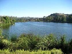
The main watercourses in Laguna Niguel are Salt Creek, which flows through the southern part of the city, and Sulphur Creek, which drains much of the northern half. Sulphur Creek is a tributary of Aliso Creek, which flows through the wide and deep Aliso Canyon before reaching the Pacific Ocean. Laguna Niguel Lake, formed by damming Sulphur Creek, is the largest body of water in the city.[26] Although Laguna Niguel is located very close to the Pacific, it does not border it, the result of a controversy over the coastline with Dana Point in 1989 (see #History).
Climate
| Laguna Niguel, California | ||||||||||||||||||||||||||||||||||||||||||||||||||||||||||||
|---|---|---|---|---|---|---|---|---|---|---|---|---|---|---|---|---|---|---|---|---|---|---|---|---|---|---|---|---|---|---|---|---|---|---|---|---|---|---|---|---|---|---|---|---|---|---|---|---|---|---|---|---|---|---|---|---|---|---|---|---|
| Climate chart (explanation) | ||||||||||||||||||||||||||||||||||||||||||||||||||||||||||||
| ||||||||||||||||||||||||||||||||||||||||||||||||||||||||||||
| ||||||||||||||||||||||||||||||||||||||||||||||||||||||||||||
Like much of coastal Southern California, Laguna Niguel has pleasant weather year-round. On average, August is the hottest month and December the coolest. The highest recorded temperature was 108 °F (42 °C), which occurred in 1963, and the lowest temperature was 21 °F (−6 °C), which was recorded in 1949. Precipitation is sparse in Laguna Niguel, as only five months out of the year receive rainfall greater than one inch, with an annual average of 14.2 inches (360 mm). The highest monthly rainfall on average occurs in February and is 3.4 inches (86 mm).[28]
Neighborhoods
Laguna Niguel is home to many upscale neighborhoods including Bear Brand Ranch, Ocean Ranch, Laguna Crest, Laguna Sur. Coronado Pointe, South Peak, Crest de Ville, Niguel Coast, Palmilla, and Monarch Pointe, which offer city, canyon, and ocean views. Other major neighborhoods include Rancho Niguel, Marina Hills, Niguel West, Niguel Summit, Beacon Hill, El Niguel Heights, Kite Hill, and San Joaquin Hills.
Demographics
| Historical population | |||
|---|---|---|---|
| Census | Pop. | %± | |
| 1970 | 4,644 | — | |
| 1980 | 12,237 | 163.5% | |
| 1990 | 44,400 | 262.8% | |
| 2000 | 61,891 | 39.4% | |
| 2010 | 62,979 | 1.8% | |
| Est. 2015 | 65,806 | [29] | 4.5% |
2010
The 2010 United States Census[30] reported that Laguna Niguel had a population of 62,979. The population density was 4,231.1 people per square mile (1,633.6/km²). The racial makeup of Laguna Niguel was 50,625 (80.4%) White (72.5% Non-Hispanic White),[5] 777 (1.2%) African American, 219 (0.3%) Native American, 5,459 (8.7%) Asian, 87 (0.1%) Pacific Islander, 3,019 (4.8%) from other races, and 2,793 (4.4%) from two or more races. Hispanic or Latino of any race were 8,761 persons (13.9%).
The Census reported that 62,731 people (99.6% of the population) lived in households, 248 (0.4%) lived in non-institutionalized group quarters, and 0 (0%) were institutionalized.[30]
There were 24,232 households, out of which 8,085 (33.4%) had children under the age of 18 living in them, 14,077 (58.1%) were opposite-sex married couples living together, 2,271 (9.4%) had a female householder with no husband present, 886 (3.7%) had a male householder with no wife present. There were 994 (4.1%) unmarried opposite-sex partnerships, and 237 (1.0%) same-sex married couples or partnerships. 5,390 households (22.2%) were made up of individuals and 1,790 (7.4%) had someone living alone who was 65 years of age or older. The average household size was 2.59. There were 17,234 families (71.1% of all households); the average family size was 3.06.[30]
The population was spread out with 14,216 people (22.6%) under the age of 18, 4,722 people (7.5%) aged 18 to 24, 14,667 people (23.3%) aged 25 to 44, 21,177 people (33.6%) aged 45 to 64, and 8,197 people (13.0%) who were 65 years of age or older. The median age was 42.8 years. For every 100 females there were 94.0 males. For every 100 females age 18 and over, there were 91.2 males.[30]
There were 25,312 housing units at an average density of 1,700.5 per square mile (656.6/km²), of which 17,453 (72.0%) were owner-occupied, and 6,779 (28.0%) were occupied by renters. The homeowner vacancy rate was 0.9%; the rental vacancy rate was 5.4%. 45,029 people (71.5% of the population) lived in owner-occupied housing units and 17,702 people (28.1%) lived in rental housing units.[30]
During 2009–2013, Laguna Niguel had a median household income of $99,771, with 6.3% of the population living below the federal poverty line.[5]
2000
As of the census[31] of 2000, there were 61,891 people, 23,217 households, and 16,785 families residing in the city. The population density was 4,221.0 inhabitants per square mile (1,630.0/km²). There were 23,885 housing units at an average density of 1,629.0 per square mile (629.1/km²). The racial makeup of the city was 83.50% White, 1.25% African American, 0.29% Native American, 7.73% Asian, 0.12% Pacific Islander, 3.48% from other races, and 3.62% from two or more races. Hispanic or Latino of any race were 10.38% of the population.[31]
There were 23,217 households out of which 38.1% had children under the age of 18 living with them, 60.2% were married couples living together, 8.8% had a female householder with no husband present, and 27.7% were non-families. 20.6% of all households were made up of individuals and 4.7% had someone living alone who was 65 years of age or older. The average household size was 2.65 and the average family size was 3.10.[31]
In the city the population was spread out with 26.6% under the age of 18, 6.0% from 18 to 24, 32.9% from 25 to 44, 25.7% from 45 to 64, and 8.9% who were 65 years of age or older. The median age was 38 years. For every 100 females there were 94.9 males. For every 100 females age 18 and over, there were 91.2 males.[31]
According to the Census Bureau's 2008 estimate, the median income for a household in the city was $98,072, and the median income for a family was $150,963.[32] Males had a median income of $68,640 versus $40,487 for females. The per capita income for the city was $50,980. About 2.8% of families and 4.1% of the population were below the poverty line, including 3.6% of those under age 18 and 4.1% of those age 65 or over.
Government and politics
The City Council consists of five members, elected from the City at-large, who serve four year staggered terms. Annually, the City Council appoints a Mayor and a Mayor Pro Tem from its own membership to serve a one-year term. The City Council currently consists of:[2]
- Laurie Davies, Mayor
- Jerry Slusiewicz, Mayor Pro Tem
- Elaine Gennawey, Council Member
- Fred Minagar, Council Member
- Gary Capata, Council Member
The city hall is located at 30111 Crown Valley Parkway.[33]
County, state and federal
In the Orange County Board of Supervisors Laguna Niguel is part of the 5th District and represented by Supervisor Lisa A. Bartlett.
In the California State Legislature, Laguna Niguel is in the 36th Senate District, represented by Republican Patricia Bates, and in the 73rd Assembly District, represented by Republican Bill Brough.[34]
In the United States House of Representatives, Laguna Niguel is in California's 48th congressional district, represented by Republican Dana Rohrabacher.[35]
Economy
As a bedroom community, most residents commute outside of Laguna Niguel to central and north Orange County cities, such as Irvine and Newport Beach. Most jobs within Laguna Niguel are in the service industry. According to the City's 2009 Comprehensive Annual Financial Report,[36] the top employers in the city are:

| # | Employer | # of employees |
|---|---|---|
| 1 | Costco | 500 |
| 2 | Wal-Mart | 280 |
| 3 | Capistrano Unified School District | 245 |
| 4 | Albertsons | 210 |
| 5 | The Home Depot | 200 |
| 6 | County of Orange | 180 |
| 7 | First Team Real Estate | 140 |
| 8 | Calstar Properties | 125 |
| 9 | Kohl's | 121 |
| 10 | Pacific Line Clean Up | 120 |
Education
The city is served by the Capistrano Unified School District.

Elementary schools
- Moulton Elementary School
- Marian Bergeson Elementary
- Crown Valley Elementary School
- Hidden Hills Elementary School
- Laguna Niguel Elementary School
- Malcolm Elementary School
- George White Elementary School
Middle schools
- Niguel Hills Middle School
- Aliso Viejo Middle School (in Aliso Viejo)
High schools
- Aliso Niguel High School (in Aliso Viejo)
- Dana Hills High School (in Dana Point)
Colleges
- Saddleback College (in Mission Viejo - Served by the South Orange County Community College District)
- Chapman University (in Orange)
- Soka University of America (in Aliso Viejo)
- University of California, Irvine (in Irvine)
- California State University, Fullerton (in Irvine)
- California State University, Fullerton (in Fullerton)
- Southern California Institute of Technology, SCIT (in Anaheim)
- Pepperdine University (in Irvine)
- Thunderwood College (Private, not-for-profit. Based in Laguna Niguel proper) As an online and largely post-geographic institution, its has ex fide affiliations with regional accreditation organizations.[37]
Private schools
Infrastructure
Emergency services
Laguna Niguel is protected by Orange County Fire Authority[39] with ambulance services provided by Care Ambulance Service. Police services are provided by Orange County Sheriff.[40] Although there are no hospitals in Laguna Niguel proper, nearby hospitals include Mission Hospital, Saddleback Memorial Hospital and South Coast Medical Center.[41]
Utilities
Electricity in Laguna Niguel is provided by Southern California Edison and San Diego Gas & Electric. Water is provided by the Moulton Niguel Water District, which is supplied by the Metropolitan Water District of Southern California's Colorado River Aqueduct and the State Water Project. Gas is supplied by San Diego Gas & Electric and The Gas Company. Waste management is provided by CR&R (Solag Disposal).[42]
Transportation
Roads
Laguna Niguel is served by Interstate 5 on the northeastern border, and the State Route 73 tollroad which runs along the northern border.[26] The Pacific Coast Highway (PCH) is located just outside the southern boundary of the city. Within the city, neighborhoods are connected by a network of 4- to 6-lane arterial roadways with timed intersections. The main thoroughfare is Crown Valley Parkway, which bisects Laguna Niguel roughly from southwest to northeast, linking the PCH in Dana Point to I-5 in Mission Viejo. The other main roads are Alicia Parkway, Niguel Road, La Paz Road, and Moulton Parkway/Golden Lantern north-south), and Aliso Creek Road, Marina Hills Drive and Camino del Avion (east-west). Due to the hilly local geography, Laguna Niguel's streets are not arranged in a grid pattern.[26]
Buses
The Orange County Transportation Authority (OCTA) operates the 85, 87, 187 and 490 bus routes in Laguna Niguel. The 490 bus line provides connecting service to the Metrolink train station.[43]
Rail
The Laguna Niguel/Mission Viejo station near I-5 is served by the Orange County Line and Inland Empire-Orange County Line of Metrolink commuter rail, providing service to points in Los Angeles, Riverside, San Bernardino and San Diego Counties.[44] The Amtrak Pacific Surfliner served Laguna Niguel from 2007 to 2012, but has since ceased to stop here. Amtrak continues to serve the nearby Irvine and San Juan Capistrano stations.[45]
Bicycling
Most major arterial roads in Laguna Niguel are marked with bike lanes. There are about 60 miles (97 km) such lanes in the city. There are also several dedicated bikeways which link Laguna Niguel's extensive public park system (see #Parks and open space).[10][46]
Parks and open space
Laguna Niguel is known throughout Orange County for its extensive park and trail system. Over one-third of Laguna Niguel is public open space, a legacy of the original 1959 Gruen plan,[10] and is divided between 31 city parks and 4 county parks.[47] Laguna Niguel's major roads are designated as "scenic highways" within landscape corridors, which includes parks, decorative medians, and grade-separated recreational paths. The 227-acre (92 ha) Laguna Niguel Regional Park is centrally located and includes an extensive trail network, ball courts and Laguna Niguel Lake, a popular fishing and boating venue.[48] Crown Valley Park, visited by about 240,000 people per year, has the city's main public sports facilities.[49] Aliso and Wood Canyons Wilderness Park, which borders Laguna Niguel on the west, consists of over 4,000 acres (1,600 ha) of canyons, grasslands and riparian forests along Aliso Creek.[50] Aliso and Wood Canyons is part of the larger South Coast Wilderness, 22,000 acres (8,900 ha) of preserved open space in the San Joaquin Hills that also includes the larger Laguna Coast Wilderness Park and Crystal Cove State Park outside the city limits. The interconnected city and regional park systems provide a significant refuge for wildlife in an area of Orange County otherwise filled with suburban sprawl.[51]
There are about 80 miles (130 km) of non-motorized trails in Laguna Niguel for hiking, biking and horseback riding.[52] Major hiking trails include the Aliso Summit trail, which hugs the rim of Aliso Canyon on the western edge of Laguna Niguel,[53] and the Colinas Bluff Trail on the eastern border, overlooking San Juan Capistrano.[54] The Laguna Ridge Trail passes through Badlands County Park, which exposes the namesake geological formations, and approaches the summit of Niguel Hill, the highest point in the city.[55] The paved Salt Creek Trail, a popular Class I bikeway, follows Salt Creek and Niguel Road from Dana Point to Laguna Niguel Regional Park. The Aliso Creek and Oso Creek trails are mostly outside Laguna Niguel, but link the city via greenbelts to other parts of south Orange County. The Aliso Creek Trail is also known as the "Forest to the Sea Trail", as it is planned to connect the Santa Ana Mountains in the Cleveland National Forest to the Pacific Ocean at Laguna Beach.[10]
Notable people
- Cady McClain, actress, singer and author
- Erik Apple, mixed martial arts fighter
- Gavyn Bailey, singer-songwriter
- Joey Richter, actor and singer
- McKayla Maroney, 2012 London Olympics medalist
- Mimi Walters, U.S. House of Representatives
- Patricia Bates, California State Senate
- Rachel Wood, soccer player
- Frank Rosenthal, professional gambler, former casino boss, and reputed Chicago Outfit associate whose life was partially depicted in Martin Scorsese's 1995 film Casino
See also
 Greater Los Angeles portal
- Laguna Niguel Classic
- United California Bank robbery
References
- ↑ "California Cities by Incorporation Date" (Word). California Association of Local Agency Formation Commissions. Retrieved August 25, 2014.
- 1 2 "Mayor & City Council". City of Laguna Niguel. Retrieved 2015-02-06.
- ↑ "2010 Census U.S. Gazetteer Files – Places – California". United States Census Bureau.
- ↑ "Laguna Niguel". Geographic Names Information System. United States Geological Survey. Retrieved February 6, 2015.
- 1 2 3 4 "Laguna Niguel (city) QuickFacts". United States Census Bureau. Retrieved February 8, 2015.
- ↑ 2011 Business and Community Directory, Laguna Niguel Chamber of Commerce, p. 7.
- ↑ "QuickFacts Orange County, California". United States Census Bureau. Retrieved 2016-07-25.
- ↑ "US Household Income". Department of Numbers. Retrieved 2016-07-25.
- ↑ Chianis, Alexia (2013-11-18). "The 50 Safest Cities in California". SafeWise. Retrieved 2016-07-25.
- 1 2 3 4 "Open Space/Parks/Conservation". General Plan for the City of Laguna Niguel. City of Laguna Niguel. 1992-08-04. Retrieved 2016-07-26.
- 1 2 3 "History and Statistics". City of Laguna Niguel. Retrieved 2016-07-25.
- 1 2 3 4 5 "Niguel Shores - A History" (PDF). Niguel Shores Community Association. Retrieved 2016-07-25.
- ↑ Hammer, Alexander R. (1969-10-14). "AVCO UNIT TO GET SHARE OF LAGUNA; $19-Million Transaction Set by the Two Concerns". The New York Times. ISSN 0362-4331. Retrieved 2016-10-14. (subscription required (help)).
- ↑ "Facts, Figures and MNWD's History". Moulton Niguel Water District. Retrieved 2016-07-28.
- 1 2 Yee, Christopher (2015-02-11). "Laguna Niguel: Looking back at our heritage". Orange County Register. Retrieved 2016-07-25.
- 1 2 "Chet Holifield Federal Building, Laguna Niguel, CA". U.S. General Services Administration. Retrieved 2016-07-25.
- ↑ Lemas, Matt (2015-08-22). "The Ziggurat: How a white elephant became a county landmark". Orange County Register. Retrieved 2016-07-25.
- ↑ Pike, Elizabeth (June 1988). "Annexation". Orange Coast Magazine. 14 (6): 99–105. ISSN 0279-0483.
- ↑ Olvera, Carlos N. (2014-01-04). "It's History: A Rough Road to Cityhood". Dana Point Times. Retrieved 2016-07-25.
- ↑ Walker, Doris I.. "Laguna Niguel". Included in: Orange County Historical Commission. (2004). A Hundred Years of Yesterdays: A Centennial History of the People of Orange County and Their Communities. pp. 169-172.
- 1 2 "Census of Population and Housing". U.S. Census Bureau. Retrieved 2015-06-04.
- ↑ Ourlian, Robert; Messina, Frank (1998-03-20). "Laguna Niguel Slide Destroys 7 Dwellings". Los Angeles Times. Retrieved 2016-07-25.
- ↑ Ourlian, Robert (1998-04-12). "Niguel Summit Project Troubled From Start". Los Angeles Times. Retrieved 2016-07-25.
- ↑ Garvey, Megan (1998-09-12). "Niguel Summit Landslide Case Settled". Los Angeles Times. Retrieved 2016-07-25.
- ↑ "US Gazetteer files: 2010, 2000, and 1990". United States Census Bureau. 2011-02-12. Retrieved 2011-04-23.
- 1 2 3 4 USGS Topo Maps for United States (Map). Cartography by United States Geological Survey. ACME Mapper. Retrieved 2009-10-29.
- ↑ County of Orange, California City Boundaries (Map). Cartography by Kevin Velasco, Orange County Public Works GIS Mapping Unit. Orange County Department of Public Works. 2011-10-25. Retrieved 2016-07-25.
- ↑ "Average Weather for Laguna Niguel, CA - Temperature and Precipitation". Weather.com. Retrieved 2013-09-19.
- ↑ "Annual Estimates of the Resident Population for Incorporated Places: April 1, 2010 to July 1, 2015". U.S. Census Bureau. Retrieved 2016-07-02.
- 1 2 3 4 5 "2010 Census Interactive Population Search: CA - Laguna Niguel city". U.S. Census Bureau. Retrieved 2014-07-12.
- 1 2 3 4 "American FactFinder". U.S. Census Bureau. Retrieved 2008-01-31.
- ↑ "US Census: Incomes in Laguna Niguel". U.S. Census Bureau.
- ↑ "City Hall". City of Laguna Niguel. Retrieved 2015-03-24.
- ↑ "Statewide Database". UC Regents. Retrieved 2014-11-23.
- ↑ "California's 48th Congressional District - Representatives & District Map". Civic Impulse, LLC.
- ↑ "City of Laguna Niguel Comprehensive Annual Financial Report: Fiscal Year Ended June 30, 2008". City of Laguna Niguel. Archived from the original on 2009-06-25. Retrieved 2016-07-26.
- ↑ "Thunderwood College". Thunderwood Holdings, Inc. Retrieved 2015-07-02.
- ↑ "St. Anne School". St. Anne School. Retrieved 2009-07-02.
- ↑ "Fire and Emergency Medical Services". City of Laguna Niguel. Retrieved 2016-07-26.
- ↑ "Police Services". City of Laguna Niguel. Retrieved 2016-07-26.
- ↑ "Local Hospitals". City of Laguna Niguel. Retrieved 2016-07-26.
- ↑ "Utility Companies". City of Laguna Niguel. Retrieved 2016-07-26.
- ↑ "OC Bus System Map" (PDF). Orange County Transportation Authority. Retrieved 2016-07-26.
- ↑ "Laguna Niguel/Mission Viejo Station". Metrolink. Retrieved 2016-07-26.
- ↑ "Laguna Niguel-Mission Viejo". TrainWeb. Retrieved 2016-07-26.
- ↑ Orange County Bikeways Map (PDF) (Map). Orange County Transportation Authority. Retrieved 2016-07-26.
- ↑ "City of Laguna Niguel Parks & Recreational Facilities Map". City of Laguna Niguel. Retrieved 2016-07-26.
- ↑ "Laguna Niguel Regional Park". OC Parks. Retrieved 2016-07-26.
- ↑ "Crown Valley Community Park". City of Laguna Niguel. Retrieved 2016-07-26.
- ↑ "Aliso and Wood Canyons Wilderness Park". OC Parks. Retrieved 2016-07-26.
- ↑ "Laguna Coast Wilderness Park". OC Parks. Retrieved 2016-07-26.
- ↑ "Trails-Hiking and Biking". City of Laguna Niguel. Retrieved 2016-07-26.
- ↑ "Aliso Summit Trail". City of Laguna Niguel. Retrieved 2016-07-26.
- ↑ "Colinas Bluff Trail". City of Laguna Niguel. Retrieved 2016-07-26.
- ↑ "Laguna RidgeTrail". City of Laguna Niguel. Retrieved 2016-07-26.
External links
 |
Aliso Viejo | Mission Viejo & Laguna Hills | Ladera Ranch | |
| San Joaquin Hills & Laguna Beach | |
San Juan Capistrano | ||
| ||||
| | ||||
| Dana Point | Dana Point | San Juan Capistrano |