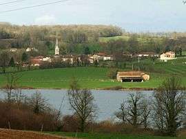
Lésignac-Durand
| Lésignac-Durand | |
|---|---|
 | |
 Lésignac-Durand | |
|
Location within Nouvelle-Aquitaine region  Lésignac-Durand | |
| Coordinates: 45°48′44″N 0°38′17″E / 45.8122°N 0.6381°ECoordinates: 45°48′44″N 0°38′17″E / 45.8122°N 0.6381°E | |
| Country | France |
| Region | Nouvelle-Aquitaine |
| Department | Charente |
| Arrondissement | Confolens |
| Canton | Montembœuf |
| Intercommunality | Haute-Charente |
| Government | |
| • Mayor (2008–2014) | Michel Duteil |
| Area1 | 19.74 km2 (7.62 sq mi) |
| Population (2008)2 | 188 |
| • Density | 9.5/km2 (25/sq mi) |
| Time zone | CET (UTC+1) |
| • Summer (DST) | CEST (UTC+2) |
| INSEE/Postal code | 16183 / 16310 |
| Elevation |
193–296 m (633–971 ft) (avg. 245 m or 804 ft) |
|
1 French Land Register data, which excludes lakes, ponds, glaciers > 1 km² (0.386 sq mi or 247 acres) and river estuaries. 2 Population without double counting: residents of multiple communes (e.g., students and military personnel) only counted once. | |
Lésignac-Durand is a commune in the Charente department in the Nouvelle-Aquitaine region in southwestern France.
Geography
The commune is found within the Rochechouart meteorite crater.
Population
| Historical population | ||
|---|---|---|
| Year | Pop. | ±% |
| 1962 | 289 | — |
| 1968 | 399 | +38.1% |
| 1975 | 352 | −11.8% |
| 1982 | 299 | −15.1% |
| 1990 | 228 | −23.7% |
| 1999 | 184 | −19.3% |
| 2008 | 188 | +2.2% |
Personalities
- Antoine Thomas, Sieur de Lézignac, adviser to the king holding the Présidial seat of Angoumois.
- The Thomas family members were aldermen, mayors of Angoulême, and advisers to the Présidial of Angoulême in the seventeenth century. The family was ennobled in 1639, 1667 and 1736.
See also
References
| Wikimedia Commons has media related to Lésignac-Durand. |
This article is issued from Wikipedia - version of the 11/11/2016. The text is available under the Creative Commons Attribution/Share Alike but additional terms may apply for the media files.