Empuré
| Empuré | |
|---|---|
 | |
 Empuré | |
|
Location within Nouvelle-Aquitaine region  Empuré | |
| Coordinates: 46°01′25″N 0°03′09″E / 46.0236°N 0.0525°ECoordinates: 46°01′25″N 0°03′09″E / 46.0236°N 0.0525°E | |
| Country | France |
| Region | Nouvelle-Aquitaine |
| Department | Charente |
| Arrondissement | Confolens |
| Canton | Villefagnan |
| Intercommunality | Pays de Villefagnan |
| Government | |
| • Mayor (2001–2008) | Alain Étourneaud |
| Area1 | 8.37 km2 (3.23 sq mi) |
| Population (2008)2 | 120 |
| • Density | 14/km2 (37/sq mi) |
| Time zone | CET (UTC+1) |
| • Summer (DST) | CEST (UTC+2) |
| INSEE/Postal code | 16127 / 16240 |
| Elevation |
84–156 m (276–512 ft) (avg. 100 m or 330 ft) |
|
1 French Land Register data, which excludes lakes, ponds, glaciers > 1 km² (0.386 sq mi or 247 acres) and river estuaries. 2 Population without double counting: residents of multiple communes (e.g., students and military personnel) only counted once. | |
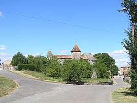
Empuré is a commune in the Charente department in southwestern France.
Bounded on the west by the Fountaine de Frédières, a small tributary of the Aume, the town lies on a plateau, located 3 km northwest of Villefagnan and 13 km west of Ruffec. The main crop is cereals.
The main route is the D27 route which crosses the commune from the north-west to south-east, which passes near the town of Empuré. The communes contains the hamlets Planchard in the west bordering the commune of Paizay-Naudouin-Embourie, Le Pouyaud to the north of the town and Bellevue etc.
Population
| Historical population | ||
|---|---|---|
| Year | Pop. | ±% |
| 1793 | 291 | — |
| 1800 | 300 | +3.1% |
| 1806 | 326 | +8.7% |
| 1821 | 332 | +1.8% |
| 1831 | 358 | +7.8% |
| 1841 | 350 | −2.2% |
| 1846 | 338 | −3.4% |
| 1851 | 320 | −5.3% |
| 1856 | 318 | −0.6% |
| 1861 | 318 | +0.0% |
| 1866 | 294 | −7.5% |
| 1872 | 289 | −1.7% |
| 1876 | 289 | +0.0% |
| 1881 | 283 | −2.1% |
| 1886 | 292 | +3.2% |
| 1891 | 262 | −10.3% |
| 1896 | 250 | −4.6% |
| 1901 | 232 | −7.2% |
| 1906 | 237 | +2.2% |
| 1911 | 240 | +1.3% |
| 1921 | 180 | −25.0% |
| 1926 | 227 | +26.1% |
| 1931 | 191 | −15.9% |
| 1936 | 188 | −1.6% |
| 1946 | 160 | −14.9% |
| 1954 | 166 | +3.8% |
| 1962 | 155 | −6.6% |
| 1968 | 151 | −2.6% |
| 1975 | 112 | −25.8% |
| 1982 | 112 | +0.0% |
| 1990 | 113 | +0.9% |
| 1999 | 108 | −4.4% |
| 2008 | 120 | +11.1% |
Sights

Église Saint-Maixent, a remarkable building from the twelfth century is characterised by its arched gateway, and the symbolic corbels that adorn its façade. It was classified a historical monument on May 9, 1914.
There is also a chateau in the commune and a town hall, built in the 16th century.
See also
References
| Wikimedia Commons has media related to Empuré. |