Cellettes, Charente
| Cellettes | |
|---|---|
|
Town hall | |
 Cellettes | |
|
Location within Nouvelle-Aquitaine region  Cellettes | |
| Coordinates: 45°51′52″N 0°08′54″E / 45.8644°N 0.1483°ECoordinates: 45°51′52″N 0°08′54″E / 45.8644°N 0.1483°E | |
| Country | France |
| Region | Nouvelle-Aquitaine |
| Department | Charente |
| Arrondissement | Confolens |
| Canton | Mansle |
| Intercommunality | Pays Manslois |
| Government | |
| • Mayor (2008–2014) | Marc Bédier |
| Area1 | 9.37 km2 (3.62 sq mi) |
| Population (2008)2 | 447 |
| • Density | 48/km2 (120/sq mi) |
| Time zone | CET (UTC+1) |
| • Summer (DST) | CEST (UTC+2) |
| INSEE/Postal code | 16069 / 16230 |
| Elevation |
52–117 m (171–384 ft) (avg. 105 m or 344 ft) |
|
1 French Land Register data, which excludes lakes, ponds, glaciers > 1 km² (0.386 sq mi or 247 acres) and river estuaries. 2 Population without double counting: residents of multiple communes (e.g., students and military personnel) only counted once. | |

Cellettes is a commune in the Charente department in southwestern France.
Population
| Historical population | ||
|---|---|---|
| Year | Pop. | ±% |
| 1793 | 403 | — |
| 1800 | 425 | +5.5% |
| 1806 | 444 | +4.5% |
| 1821 | 425 | −4.3% |
| 1831 | 482 | +13.4% |
| 1841 | 475 | −1.5% |
| 1846 | 455 | −4.2% |
| 1851 | 503 | +10.5% |
| 1856 | 480 | −4.6% |
| 1861 | 509 | +6.0% |
| 1866 | 508 | −0.2% |
| 1872 | 501 | −1.4% |
| 1876 | 551 | +10.0% |
| 1881 | 624 | +13.2% |
| 1886 | 517 | −17.1% |
| 1891 | 445 | −13.9% |
| 1896 | 384 | −13.7% |
| 1901 | 342 | −10.9% |
| 1906 | 333 | −2.6% |
| 1911 | 358 | +7.5% |
| 1921 | 312 | −12.8% |
| 1926 | 318 | +1.9% |
| 1931 | 330 | +3.8% |
| 1936 | 293 | −11.2% |
| 1946 | 246 | −16.0% |
| 1954 | 249 | +1.2% |
| 1962 | 250 | +0.4% |
| 1968 | 259 | +3.6% |
| 1975 | 222 | −14.3% |
| 1982 | 294 | +32.4% |
| 1990 | 346 | +17.7% |
| 1999 | 417 | +20.5% |
| 2008 | 447 | +7.2% |
Gallery
 Forêt de Boixe in winter
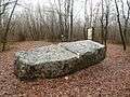 Dolmen also wrongly said as a "sacrifice table", is located in the Forêt de Boixe
 Chapel of the Château d'Échoisy
See also
References
| Wikimedia Commons has media related to Cellettes (Charente). |
This article is issued from Wikipedia - version of the 7/13/2016. The text is available under the Creative Commons Attribution/Share Alike but additional terms may apply for the media files.