Combiers
| Combiers | |
|---|---|
 | |
 Combiers | |
|
Location within Nouvelle-Aquitaine region  Combiers | |
| Coordinates: 45°29′36″N 0°24′56″E / 45.4933°N 0.4156°ECoordinates: 45°29′36″N 0°24′56″E / 45.4933°N 0.4156°E | |
| Country | France |
| Region | Nouvelle-Aquitaine |
| Department | Charente |
| Arrondissement | Angoulême |
| Canton | Villebois-Lavalette |
| Intercommunality | Horte et Lavalette |
| Government | |
| • Mayor (2008–2014) | Raymond Borderon |
| Area1 | 23.96 km2 (9.25 sq mi) |
| Population (2008)2 | 115 |
| • Density | 4.8/km2 (12/sq mi) |
| Time zone | CET (UTC+1) |
| • Summer (DST) | CEST (UTC+2) |
| INSEE/Postal code | 16103 / 16320 |
| Elevation |
90–215 m (295–705 ft) (avg. 100 m or 330 ft) |
|
1 French Land Register data, which excludes lakes, ponds, glaciers > 1 km² (0.386 sq mi or 247 acres) and river estuaries. 2 Population without double counting: residents of multiple communes (e.g., students and military personnel) only counted once. | |
Combiers is a commune in the Charente department in southwestern France.
Geography
The Lizonne (locally called Nizonne) forms most of the commune's southern border.
Population
| Historical population | ||
|---|---|---|
| Year | Pop. | ±% |
| 1793 | 619 | — |
| 1800 | 679 | +9.7% |
| 1806 | 700 | +3.1% |
| 1821 | 630 | −10.0% |
| 1831 | 638 | +1.3% |
| 1841 | 675 | +5.8% |
| 1846 | 627 | −7.1% |
| 1851 | 631 | +0.6% |
| 1856 | 609 | −3.5% |
| 1861 | 624 | +2.5% |
| 1866 | 558 | −10.6% |
| 1872 | 558 | +0.0% |
| 1876 | 542 | −2.9% |
| 1881 | 504 | −7.0% |
| 1886 | 506 | +0.4% |
| 1891 | 445 | −12.1% |
| 1896 | 444 | −0.2% |
| 1901 | 407 | −8.3% |
| 1906 | 386 | −5.2% |
| 1911 | 379 | −1.8% |
| 1921 | 341 | −10.0% |
| 1926 | 342 | +0.3% |
| 1931 | 319 | −6.7% |
| 1936 | 325 | +1.9% |
| 1946 | 360 | +10.8% |
| 1954 | 271 | −24.7% |
| 1962 | 242 | −10.7% |
| 1968 | 214 | −11.6% |
| 1975 | 154 | −28.0% |
| 1982 | 145 | −5.8% |
| 1990 | 127 | −12.4% |
| 1999 | 114 | −10.2% |
| 2008 | 115 | +0.9% |
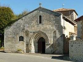
Sights
- Arboretum Jean Aubouin
- The grandmontine priory of Rauzet
See also
References
| Wikimedia Commons has media related to Combiers. |
This article is issued from Wikipedia - version of the 5/26/2015. The text is available under the Creative Commons Attribution/Share Alike but additional terms may apply for the media files.