Magnac-sur-Touvre
| Magnac-sur-Touvre | ||
|---|---|---|
 | ||
| ||
 Magnac-sur-Touvre | ||
|
Location within Nouvelle-Aquitaine region  Magnac-sur-Touvre | ||
| Coordinates: 45°39′59″N 0°14′18″E / 45.6664°N 0.2383°ECoordinates: 45°39′59″N 0°14′18″E / 45.6664°N 0.2383°E | ||
| Country | France | |
| Region | Nouvelle-Aquitaine | |
| Department | Charente | |
| Arrondissement | Angoulême | |
| Canton | Ruelle-sur-Touvre | |
| Intercommunality | Grand Angoulême | |
| Government | ||
| • Mayor (2008–2014) | Bernard Contamine | |
| Area1 | 7.82 km2 (3.02 sq mi) | |
| Population (2008)2 | 3,032 | |
| • Density | 390/km2 (1,000/sq mi) | |
| Time zone | CET (UTC+1) | |
| • Summer (DST) | CEST (UTC+2) | |
| INSEE/Postal code | 16199 / 16600 | |
| Elevation | 42–156 m (138–512 ft) | |
|
1 French Land Register data, which excludes lakes, ponds, glaciers > 1 km² (0.386 sq mi or 247 acres) and river estuaries. 2 Population without double counting: residents of multiple communes (e.g., students and military personnel) only counted once. | ||

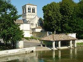
Magnac-sur-Touvre is a commune in the Charente department in southwestern France.
Population
| Historical population | ||
|---|---|---|
| Year | Pop. | ±% |
| 1793 | 647 | — |
| 1800 | 594 | −8.2% |
| 1806 | 529 | −10.9% |
| 1821 | 602 | +13.8% |
| 1831 | 602 | +0.0% |
| 1841 | 932 | +54.8% |
| 1846 | 979 | +5.0% |
| 1851 | 1,058 | +8.1% |
| 1856 | 1,004 | −5.1% |
| 1861 | 1,037 | +3.3% |
| 1866 | 1,005 | −3.1% |
| 1872 | 1,177 | +17.1% |
| 1876 | 1,187 | +0.8% |
| 1881 | 1,553 | +30.8% |
| 1886 | 1,592 | +2.5% |
| 1891 | 1,619 | +1.7% |
| 1896 | 1,830 | +13.0% |
| 1901 | 1,830 | +0.0% |
| 1906 | 1,820 | −0.5% |
| 1911 | 1,801 | −1.0% |
| 1921 | 1,597 | −11.3% |
| 1926 | 1,612 | +0.9% |
| 1931 | 1,682 | +4.3% |
| 1936 | 1,871 | +11.2% |
| 1946 | 1,857 | −0.7% |
| 1954 | 1,921 | +3.4% |
| 1962 | 2,170 | +13.0% |
| 1968 | 2,393 | +10.3% |
| 1975 | 2,645 | +10.5% |
| 1982 | 2,842 | +7.4% |
| 1990 | 2,843 | +0.0% |
| 1999 | 2,829 | −0.5% |
| 2008 | 3,032 | +7.2% |
See also
References
External links
| Wikimedia Commons has media related to Magnac-sur-Touvre. |
This article is issued from Wikipedia - version of the 7/16/2016. The text is available under the Creative Commons Attribution/Share Alike but additional terms may apply for the media files.