Les Gours
| Les Gours | |
|---|---|
|
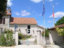
Town hall | |
 Les Gours | |
|
Location within Nouvelle-Aquitaine region  Les Gours | |
| Coordinates: 45°57′45″N 0°03′57″W / 45.9625°N 0.0658°WCoordinates: 45°57′45″N 0°03′57″W / 45.9625°N 0.0658°W | |
| Country | France |
| Region | Nouvelle-Aquitaine |
| Department | Charente |
| Arrondissement | Confolens |
| Canton | Aigre |
| Intercommunality | Pays d'Aigre |
| Government | |
| • Mayor (2008–2014) | Didier Texier |
| Area1 | 11.42 km2 (4.41 sq mi) |
| Population (2008)2 | 126 |
| • Density | 11/km2 (29/sq mi) |
| Time zone | CET (UTC+1) |
| • Summer (DST) | CEST (UTC+2) |
| INSEE/Postal code | 16155 / 16140 |
| Elevation |
77–119 m (253–390 ft) (avg. 85 m or 279 ft) |
|
1 French Land Register data, which excludes lakes, ponds, glaciers > 1 km² (0.386 sq mi or 247 acres) and river estuaries. 2 Population without double counting: residents of multiple communes (e.g., students and military personnel) only counted once. | |
Les Gours is a commune in the Charente department in southwestern France.
Population
| Historical population | ||
|---|---|---|
| Year | Pop. | ±% |
| 1793 | 242 | — |
| 1800 | 224 | −7.4% |
| 1806 | 306 | +36.6% |
| 1821 | 305 | −0.3% |
| 1831 | 308 | +1.0% |
| 1841 | 262 | −14.9% |
| 1846 | 280 | +6.9% |
| 1851 | 255 | −8.9% |
| 1856 | 262 | +2.7% |
| 1861 | 281 | +7.3% |
| 1866 | 264 | −6.0% |
| 1872 | 247 | −6.4% |
| 1876 | 219 | −11.3% |
| 1881 | 250 | +14.2% |
| 1886 | 219 | −12.4% |
| 1891 | 227 | +3.7% |
| 1896 | 203 | −10.6% |
| 1901 | 181 | −10.8% |
| 1906 | 209 | +15.5% |
| 1911 | 198 | −5.3% |
| 1921 | 196 | −1.0% |
| 1926 | 203 | +3.6% |
| 1931 | 195 | −3.9% |
| 1936 | 207 | +6.2% |
| 1946 | 198 | −4.3% |
| 1954 | 221 | +11.6% |
| 1962 | 227 | +2.7% |
| 1968 | 189 | −16.7% |
| 1975 | 163 | −13.8% |
| 1982 | 143 | −12.3% |
| 1990 | 142 | −0.7% |
| 1999 | 145 | +2.1% |
| 2008 | 126 | −13.1% |
See also
References
| Wikimedia Commons has media related to Les Gours. |
This article is issued from Wikipedia - version of the 7/20/2016. The text is available under the Creative Commons Attribution/Share Alike but additional terms may apply for the media files.