Agoura Hills, California
| Agoura Hills, California | |
|---|---|
| General law city[1] | |
| City of Agoura Hills | |
|
View of Agoura Hills looking from southern edge of the Historic Quarter in December 2006. | |
| Motto: "The Gateway to the Santa Monica Mountains"[2] | |
 Location of Agoura Hills in California | |
 Agoura Hills, California Location in the United States | |
| Coordinates: 34°9′12″N 118°45′42″W / 34.15333°N 118.76167°WCoordinates: 34°9′12″N 118°45′42″W / 34.15333°N 118.76167°W | |
| Country |
|
| State |
|
| County |
|
| Settled (by the Spanish) | 1700s |
| Incorporated | December 8, 1982[3] |
| Government | |
| • Type | City Council/City Manager[1] |
| • Mayor | Harry Schwartz[1] |
| • Mayor pro tem | Denis Weber |
| Area[4] | |
| • Total | 7.822 sq mi (20.260 km2) |
| • Land | 7.793 sq mi (20.184 km2) |
| • Water | 0.029 sq mi (0.076 km2) 0.37% |
| Elevation[5] | 922 ft (281 m) |
| Population (April 1, 2010)[6] | |
| • Total | 20,330 |
| • Estimate (2013)[6] | 20,681 |
| • Density | 2,600/sq mi (1,000/km2) |
| Time zone | Pacific Time Zone (UTC-8) |
| • Summer (DST) | PDT (UTC-7) |
| ZIP codes | 91301, 91376, 91377[7] |
| Area code | 747/818[8] |
| FIPS code | 06-00394[6] |
| GNIS feature IDs | 1667896, 2409666 |
| Website |
www |

Agoura Hills is a city in Los Angeles County, California. Its population was estimated to be at 20,843 in 2014,[9] up from 20,537 at the 2000 census. It is in the eastern Conejo Valley between the Simi Hills and the Santa Monica Mountains. The city is on the border between the county of Los Angeles to the east, west and south and Ventura County to the north. It is about 30 miles (48 km) northwest of Downtown Los Angeles and less than 10 miles (16 km) west of the Los Angeles City limits (Woodland Hills). Agoura Hills and unincorporated Agoura sit next to Calabasas, Oak Park, and Westlake Village.
History
The area was first settled by the Chumash Native Americans around 10,000 years ago.[10] As the Alta California (Upper California) coast was settled by Spanish Franciscan missionaries in the late 18th century, the El Camino Real (the Royal Road or King's Highway), a road from Loreto, Baja California, Mexico to Sonoma, California, and connecting the Spanish missions in California, was established through the heart of what would later be known as Agoura Hills.
In about 1800, Miguel Ortega was granted a Spanish grazing concession called Rancho Las Virgenes or El Rancho de Nuestra Señora La Reina de Las Virgenes. The grant was abandoned after Ortega's death in 1810, and José Maria Dominguez was given Rancho Las Virgenes as a Mexican land grant in 1834. Maria Antonia Machado de Reyes purchased the rancho from Dominguez in 1845. (The "Reyes Adobe" ranch headquarters sits today in central Agoura Hills, where it is part of the Reyes Adobe Museum built around 2004 and owned by the Los Angeles County Parks and Recreation Department.[11])
By 1900, Agoura Hills was being used as a popular stage stop for travelers along the Camino Real because of its natural spring at the foothills of Ladyface Mountain, one of Agoura Hills' defining geographic features.
In the 1920s, the community was briefly known as Picture City, as Paramount Pictures owned a ranch in the area used for filming Westerns. To obtain a post office of their own, the residents were required to choose a one-word name, and in 1927 chose the shortest name proposed: a misspelling of the last name of Pierre Agoure, a local Basque man and French immigrant who had settled in the area in 1871 to live the lifestyle of the Mexican rancher. Styling himself Don Pierre Agoure,[12] he was a successful sheep herder and had a reputation as a swashbuckler.[13]

Agoura Hills began to grow in the late 1960s after the Ventura Freeway section of U.S. Route 101 was built through the city's heart, isolating its northern half from its south. The first housing tracts in Agoura were Hillrise, Liberty Canyon and Lake Lindero. Rapid growth continued during the 1970s, when schools were built and much of downtown erected.
In 1978, residents of the Agoura Hills area banded together to lobby Sacramento to widen the Kanan Bridge. Legislation was passed requiring the State Department of Transportation to award contracts for widening of the Kanan Road bridge overpass, over the Ventura Freeway, from two lanes to four lanes.
In 1982, the residents of the City of Agoura Hills voted in favor of cityhood by a 68% majority. Agoura Hills became the 83rd City in Los Angeles County. Elected to the first City Council were Mayor Fran Pavley, Mayor Pro Tem Carol Sahm, Councilmembers Ernest Dynda, John Hood and Vicky Leary.[14] Incorporating a year after neighboring Westlake Village, the drive for cityhood in the region was largely based on public discontent with the county's failure to limit residential development of the area, motives that influenced Malibu and Calabasas to follow suit in 1991.[15]
The 1980s was a period of tremendous growth, with large land areas being subdivided into housing tracts and a great wave of migration of people into the city. In the 1990s, numerous businesses set up shop in the city, and downtown filled with shops and restaurants.
In 1995, the murder of Jimmy Farris (the infamous Brandon Hein case) shook the city and awakened it to a rising drug problem and petty theft crime wave among its young. As a result, the city began sponsoring live music competitions and concerts in local parks (see Music).
Geography
According to the United States Census Bureau, the city has a total area of 8.2 square miles (21 km2). 8.2 square miles (21 km2) of it is land and 0.04 square miles (0.10 km2) of it (0.37%) is water
Agoura Hills has a mountain called Ballard Mountain named after pioneer settler and freed slave John Ballard. The name of the mountain was officially changed from Negrohead to Ballard in a ceremony on February 20, 2010.[16] Ladyface mountain[17] is another prominent mountain on the west side of the Conejo Valley and stands at 2,031 feet high.

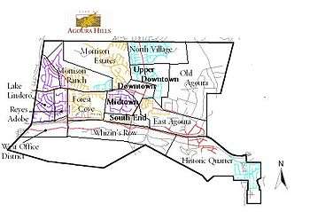
Agoura Hills is called the "Gateway to the Santa Monica Mountains National Recreation Area".[18] The city is unofficially divided into a number of varied districts centered on the modern Downtown area of the city. The most notable of these districts include Morrison Ranch, Downtown, Forest Cove, South End, Malibu Junction, East Agoura, and Old Agoura.
Environment
Natural areas of Agoura Hills are part of the California chaparral and woodlands ecoregion and are covered by hundreds of local plant species, some of which are very rare, and others of which have become popular ornamentals. The range is host to an immense variety of wildlife, from mountain lions to the endangered Southern California Distinct Population Segment of steelhead.[19] The Mountain lion population within the Santa Monica Mountains (which includes the Simi Hills & Santa Susana Pass) is severely depleted with only seven known living adult individuals. The primary cause of the decline is due to a combination of traffic related mortality (three from the area were killed within a matter of months,) anti-coagulants ingested from human poisoned prey (two individuals within the Simi Hills) and attacks by other, more dominant mountain lions (an elder male, known as P1, killed both his son and his mate, this is thought to be due to a lack of space available.) Snakes are common but only occasionally seen- the Southern Pacific Rattlesnake (the only venomous species), Mountain Kingsnake, California Kingsnake, Gopher snake, and Garter snake. The mountains are also home to the Western fence lizard.
Invasive species
In 2010, the Los Angeles Times reported that the New Zealand mud snail had infested watersheds in the Santa Monica Mountains, posing serious threats to native species and complicating efforts to improve stream-water quality for the endangered steelhead trout. According to the article, the snails have expanded "from the first confirmed sample in Medea Creek in Agoura Hills to nearly 30 other stream sites in four years." Researchers at the Santa Monica Bay Restoration Commission believe that the snails' expansion may have been expedited after the mollusks traveled from stream to stream on the gear of contractors and volunteers.[20]
Music
Agoura Hills is known regionally for its live music scene and originality in the nu metal scene, a fame that has given rise to such acts as Linkin Park, Foxygen, Dub Thompson, Skye Aspen, Incubus, Hoobastank, and Fort Minor.
This music scene was born amid the coming of age of the children of the first wave of migration into Agoura Hills, those that settled in the 1960s. The 1980s was the first boom in the music scene, but by the late 1980s, as many of these original rockers moved off to college or aged, the scene declined.

However, in the mid-1990s the music scene began to take off again, energized by the coming of age of the children of those who had settled in the early 1980s. The 1996 Jimmy Farris murder case (popularized by defendant Brandon Hein) spurred many city leaders to action in promoting the arts among teenagers, hoping to ward off a rising crime wave. This patronage helped re-popularize live music among teenagers, and created the fertile ground that led to the take off of Linkin Park and Hoobastank.
However, by the first decade of the 21st century, much of this wave of teenagers had aged or gone to college, leaving the scene with only a shell of the energy it once had. Although the scene lives on, pushed forward by various Battle of the Bands competitions and garage concerts, the lack of a third major wave of migration to Agoura Hills (construction having been relatively maxed out in the second migration) makes a major renaissance seem doubtful as of early 2007. Demographic data suggests a possible resurgence within the coming years, but current data shows that the majority of young people in the city are in the 10 to 14 years old age group, leaving a comeback to some years in the future.[21]
As a result of this decline, it has become equally common to hear alt-rock blaring from stereos in Agoura as to hear reggaeton, a fact evidenced by radio station Latino 96.3's advertising campaign and runaway popularity in Agoura Hills.
Agoura Hills is home to The Canyon Club, a highly regarded concert venue that hosts national and regional touring acts such as Peter Frampton, Pat Benatar, Cyndi Lauper, REO Speedwagon, X, Steel Pulse, The New Cars, Asia, Boyz II Men, Alan Parsons, Foreigner, Bret Michaels and The Smithereens.
Demographics
| Historical population | |||
|---|---|---|---|
| Census | Pop. | %± | |
| 1990 | 20,390 | — | |
| 2000 | 20,537 | 0.7% | |
| 2010 | 20,330 | −1.0% | |
| Est. 2015 | 20,915 | [22] | 2.9% |

2010
The 2010 United States Census[24] reported that Agoura Hills had a population of 20,330. The population density was 2,599.0 people per square mile (1,003.5/km²). The racial makeup of Agoura Hills was 17,147 (84.3%) White, (78.6% Non-Hispanic White), 267 (1.3%) African American, 51 (0.3%) Native American, 1,521 (7.5%) Asian, 24 (0.1%) Pacific Islander, 590 (2.9%) from other races, and 730 (3.6%) from two or more races. Hispanic or Latino of any race were 1,936 persons (9.5%).
The Census reported that 20,242 people (99.6% of the population) lived in households, 15 (0.1%) lived in non-institutionalized group quarters, and 73 (0.4%) were institutionalized.
There were 7,327 households, out of which 2,799 (38.2%) had children under the age of 18 living in them, 4,565 (62.3%) were opposite-sex married couples living together, 726 (9.9%) had a female householder with no husband present, 302 (4.1%) had a male householder with no wife present. There were 263 (3.6%) unmarried opposite-sex partnerships, and 36 (0.5%) same-sex married couples or partnerships. 1,346 households (18.4%) were made up of individuals and 438 (6.0%) had someone living alone who was 65 years of age or older. The average household size was 2.76. There were 5,593 families (76.3% of all households); the average family size was 3.15.
The population was spread out with 4,904 people (24.1%) under the age of 18, 1,582 people (7.8%) aged 18 to 24, 4,465 people (22.0%) aged 25 to 44, 7,089 people (34.9%) aged 45 to 64, and 2,290 people (11.3%) who were 65 years of age or older. The median age was 42.4 years. For every 100 females there were 97.2 males. For every 100 females age 18 and over, there were 94.6 males.
There were 7,585 housing units at an average density of 969.7 per square mile (374.4/km²), of which 5,715 (78.0%) were owner-occupied, and 1,612 (22.0%) were occupied by renters. The homeowner vacancy rate was 0.5%; the rental vacancy rate was 6.8%. 16,111 people (79.2% of the population) lived in owner-occupied housing units and 4,131 people (20.3%) lived in rental housing units. The median household income was $107,885, according to the 2010 United States Census, with 7.1% of the population living below the federal poverty line.
2000
As of the census[25] of 2000, there were 20,537 people, 6,874 households, and 5,588 families residing in the city. The population density was 2,511.8 inhabitants per square mile (969.4/km2). There were 6,993 housing units at an average density of 855.3 per square mile (330.1/km2). The racial makeup of the city was 86.96% White, 1.32% Black or African American, 0.25% Native American, 6.50% Asian, 0.10% Pacific Islander, 2.09% from other races, and 2.78% from two or more races. 6.85% of the population were Hispanic or Latino of any race.
There were 6,874 households out of which 47.3% had children under the age of 18 living with them, 67.7% were married couples living together, 9.9% had a female householder with no husband present, and 18.7% were non-families. 13.8% of all households were made up of individuals and 3.0% had someone living alone who was 65 years of age or older. The average household size was 2.98 and the average family size was 3.30.
In the city the population was spread out with 30.5% under the age of 18, 6.3% from 18 to 24, 27.6% from 25 to 44, 29.4% from 45 to 64, and 6.2% who were 65 years of age or older. The median age was 38 years. For every 100 females there were 99.1 males. For every 100 females age 18 and over, there were 94.0 males.

Economy
Top employers
According to the City's 2015 Comprehensive Annual Financial Report,[26] the top employers in the city are:
| # | Employer | # of Employees |
|---|---|---|
| 1 | Bank of America | 873 |
| 2 | Las Virgenes Unified School District | 543 |
| 3 | Teradyne | 220 |
| 4 | TouchCommerce | 210 |
| 5 | IBM Corporation | 206 |
| 6 | Farmers Financial Solutions | 151 |
| 7 | Zebra Technologies | 147 |
| 8 | Nationwide Medical | 110 |
| 9 | Wood Ranch | 100 |
| 10 | Sheraton Agoura Hills | 82 |
Government
Agoura Hills is governed by a City Council/City Manager form of government. A five-member City Council is elected by the residents to oversee city operations and guide the development of the community. Councilmembers are elected to four-year terms.[27] The terms are staggered so that a measure of continuity is maintained from one Council to the next. The role of Mayor rotates among the Councilmembers. The Mayor is chosen by the City Councilmembers to serve a one-year term.[27] The City Manager is appointed by the City Council to supervise the administrative personnel and contract services.[28]
As of December 2014, the Agoura Hills City Council consists of Harry Schwartz (Mayor), Denis Weber (Mayor Pro Tem), Illece Buckley Weber, William D. Koehler, and Linda L. Northrup.[29] The City Manager is Greg Ramirez[30] and the city attorney is Craig Steele.
State and federal representation
In the California State Legislature, Agoura Hills is in the 27th Senate District, represented by Democrat Henry Stern, and in the 50th Assembly District, represented by Democrat Richard Bloom.[31]
In the United States House of Representatives, Agoura Hills is in California's 33rd congressional district, represented by Democrat Ted Lieu.[32]
Politics
In the 2004 presidential election John Kerry won 52% of the vote, while George W. Bush won 46% of the vote. In the 2006 state gubernatorial election, Arnold Schwarzenegger got just over 62% of the vote, while Democratic opponent Phil Angelides got over 34%. In the 2008 presidential election, however, Barack Obama won 69% of the vote in Agoura Hills, while John McCain only won 29% of the vote.
Infrastructure
Las Virgenes Water District serves Agoura Hills along with Westlake Village and other parts of western Los Angeles County. State water provided by the Metropolitan Water District of Southern California is the sole source used by the district.[33]
The Los Angeles County Sheriff's Department (LASD) operates the Malibu/Lost Hills Station in Calabasas, serving Agoura Hills.[34][35]
The United States Postal Service Agoura Hills Post Office is located at 5158 Clareton Drive.[36]
Events
Agoura Hills is home to the Great Race of Agoura Hills, an annual running event held at Chumash Park in Agoura Hills in March of every year. The Great Race was established in 1986 and features six races including Pacific Half (Half Marathon), Chesebro Half (Half Marathon), Old Agoura 10K, Deena Kastor (5 Kilometers), Kids 1 Mile, and the Family Fun Run (1 Mile). The Chesebro Half was voted Best Half Marathon in the U.S. in 2011.[37]
Education
The Las Virgenes Unified School District serves Agoura Hills.
- Sumac Elementary School
- Willow Elementary School
- Yerba Buena Elementary School
- Lindero Canyon Middle School
- Agoura High School
- Indian Hills High School
Sports
Agoura Hills will be the corporate headquarters of the Los Angeles Rams through 2019.[38]
Notable people and acts
- Ron Goldman, waiter and deceased friend of Nicole Brown Simpson
- Skip Hicks, former UCLA running back and NFL and CFL football player
- Johnny Gyro, seven time karate world champion (owns studio in Oak Park, CA)
- Adam Levine Grew up in Agoura (his parents still live there)
- Erin Brockovich, environmental activist
- Jason Wade, singer and musician
- Mike Shinoda, musician from Alternative rock group Linkin Park
- Linkin Park, band
- Doug Robb, singer from Post-grunge group Hoobastank
- Heather Graham, actress
- Todd Steussie, NFL offensive lineman
- Grant Kirkhope, composer
- Russell Peters, comedian
- Brooke Candy, artist and musician
- Mark L. Young, actor
- Deena Kastor, Olympic medalist/American Record holder Marathon
- Clay Matthews, NFL linebacker for the Green Bay Packers
- Casey Matthews, NFL linebacker for the Philadelphia Eagles
- Guillermo del Toro, Mexican film director. He lived in Agoura Hills for a few years before he moved to Toronto, Canada in January 2015.
- Harry Nilsson, singer-songwriter
- Foxygen, band
- Ray Romano, comedian
- Rob Paulsen, voice actor
- Frank Welker, voice actor
- Cinco Paul, screenwriter
- Rob Chiarelli, Grammy Award winner[39][40]
- Kirk Cameron, actor[41]
- Terri Nunn, musician from new wave group Berlin, actress, radio host[42]
- Warren Hill, jazz musician
- Olivia Rox, American Idol (season 15) finalist and daughter of Warren Hill
- Rainn Wilson, film and television actor
References
- 1 2 3 "Council Members". City of Agoura Hills, CA. Retrieved December 16, 2014.
- ↑ "City of Agoura Hills, California". City of Agoura Hills, California. Retrieved August 11, 2012.
- ↑ "California Cities by Incorporation Date" (Word). California Association of Local Agency Formation Commissions. Retrieved August 25, 2014.
- ↑ "2010 Census U.S. Gazetteer Files – Places – California". United States Census Bureau.
- ↑ "Agoura". Geographic Names Information System. United States Geological Survey. Retrieved October 16, 2014.
- 1 2 3 "Agoura Hills (city) QuickFacts". United States Census Bureau. Retrieved March 26, 2015.
- ↑ "USPS – ZIP Code Lookup – Find a ZIP+ 4 Code By City Results". Retrieved January 17, 2007.
- ↑ "Number Administration System – NPA and City/Town Search Results". Retrieved January 18, 2007.
- ↑ "Annual Estimates of the Resident Population for Incorporated Places: April 1, 2010 to July 1, 2014". Retrieved June 4, 2015.
- ↑ C. M. Hogan, 2008
- ↑ "Reyes Adobe". February 15, 2012.
- ↑ http://www.findagrave.com/cgi-bin/fg.cgi?page=gr&GSvcid=9332&GRid=14344192& findagrave.com
- ↑ http://www.colapublib.org/history/agourahills/faq.html colapublib.org
- ↑ http://www.ci.agoura-hills.ca.us/history.html ci.agoura-hills.ca.us
- ↑ http://desperado.scvnet.com/~philh/scope/articles/inthenews/lat-smm-1.html desperado.scvnet.com
- ↑ Associated Press (February 20, 2010). "Calif.'s Negrohead Mountain renamed for pioneer". Newsvine. Retrieved February 21, 2010.
- ↑ U.S. Geological Survey Geographic Names Information System: Ladyface
- ↑ "City of Agoura Hills, California". City of Agoura Hills, California. Retrieved August 12, 2016.
- ↑ "South-Central/Southern California Coast Steelhead Recovery Planning Domain 5-Year Review: Summary and Evaluation of Southern California Coast Steelhead Distinct Population Segment" (PDF). National Oceanic and Atmospheric Administration. 2011. Retrieved 2013-12-03.
- ↑ Hard-to-kill snails infest Santa Monica Mountain watersheds Even Formula 409 has proven ineffective at destroying the New Zealand mudsnail, an asexually reproducing invasive species that poses a threat to steelhead restoration efforts and native creatures.
- ↑ ww4.onboardnavigator.com
- ↑ "Annual Estimates of the Resident Population for Incorporated Places: April 1, 2010 to July 1, 2015". Retrieved July 2, 2016.
- ↑ "Census of Population and Housing". Census.gov. Archived from the original on May 11, 2015. Retrieved June 4, 2015.
- ↑ "The United States Census - QuickFacts - Agoura Hills city, California". Retrieved August 1, 2016.
- ↑ "American FactFinder". United States Census Bureau. Archived from the original on September 11, 2013. Retrieved January 31, 2008.
- ↑ City of Agoura Hills CAFR
- 1 2 City of Agoura Hills Website: Local Election Information. http://ci.agoura-hills.ca.us/Modules/ShowDocument.aspx?documentid=6913
- ↑ City of Agoura Hills Website. http://ci.agoura-hills.ca.us/Index.aspx?page=24
- ↑ Council Members
- ↑ City Manager
- ↑ "Statewide Database". UC Regents. Retrieved December 8, 2014.
- ↑ "California's 33rd Congressional District - Representatives & District Map". Civic Impulse, LLC.
- ↑ Barlow, Zeke (February 3, 2009) "With drought expected to worsen, water officials drawing up rationing rules" Ventura County Star
- ↑ "Malibu/Lost Hills Station." Los Angeles County Sheriff's Department. Retrieved on January 21, 2010.
- ↑ "Calabasas city, California." U.S. Census Bureau. Retrieved on January 21, 2010.
- ↑ "Post Office Location – AGOURA HILLS." United States Postal Service. Retrieved on December 6, 2008.
- ↑ Active.com
- ↑ Klein, Gary (April 4, 2016). "Rams' temporary offices in Agoura Hills are open for (non-football) business". latimes.com. LA Times. Retrieved April 27, 2016.
- ↑ "MTV". MTV Viacom International. Retrieved 2015-06-29.
- ↑ "Top-40 Charts". Top-40 Charts. Retrieved 2013-11-03.
- ↑ "Kirk Cameron's House". Virtual Globetrotting.
- ↑ "Berlin's Terri Nunn: An Agoura Girl at Heart". Agoura Hills, California Patch.
External links
| Wikivoyage has a travel guide for Agoura Hills. |
 |
Simi Hills | Oak Park Simi Hills |
Simi Hills | |
| Westlake Village | |
Simi Hills Calabasas | ||
| ||||
| | ||||
| Santa Monica Mountains | Santa Monica Mountains Calabasas |
