| [3] |
Name on the Register[4] |
Image |
Date listed[5] |
Location |
City or town |
Description |
|---|
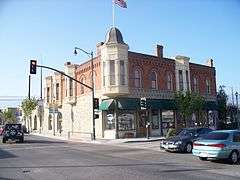
| 1 |
Anacapa Island Archeological District |
|
000000001979-09-12-0000September 12, 1979
(#79000257) |
Address Restricted
|
Port Hueneme |
|
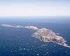
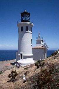
| 2 |
Anacapa Island Light Station |
|
000000001991-09-03-0000September 3, 1991
(#91001101) |
Anacapa Island, Channel Islands National Park
34°00′56″N 119°21′39″W / 34.015556°N 119.360833°W / 34.015556; -119.360833 (Anacapa Island Light Station) |
Oxnard |
|
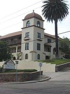
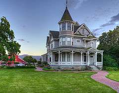
| 3 |
Elizabeth Bard Memorial Hospital |
|
000000001977-11-11-0000November 11, 1977
(#77000361) |
121 N. Fir St.
34°16′56″N 119°17′18″W / 34.282222°N 119.288333°W / 34.282222; -119.288333 (Elizabeth Bard Memorial Hospital) |
Ventura |
|
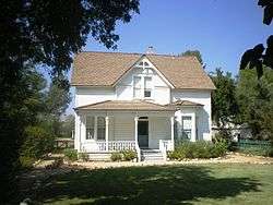
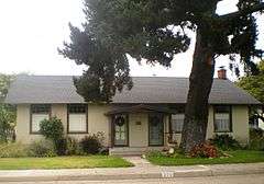
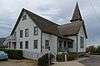
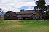
| 4 |
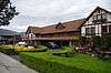
Bardsdale Methodist Episcopal Church |
|
000000001986-08-28-0000August 28, 1986
(#86001986) |
1498 Bardsdale Ave.
34°22′17″N 118°55′55″W / 34.371389°N 118.931944°W / 34.371389; -118.931944 (Bardsdale Methodist Episcopal Church) |
Fillmore |
In 1898, a local group of German Evangelical Church Members joined with their friends and neighbors to “Step Out in Faith” and build the carpenter gothic building we now know as the Bardsdale United Methodist Church.
|
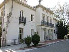
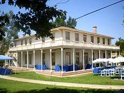
| 5 |
Berylwood |
|
000000001977-09-15-0000September 15, 1977
(#77000360) |
Ventura Rd.
34°09′28″N 119°11′48″W / 34.157778°N 119.196667°W / 34.157778; -119.196667 (Berylwood) |
Port Hueneme |
Bard family's 62-acre (250,000 m2) estate; leased by the Navy during World War II and acquired by the government in 1951
|
| 6 |
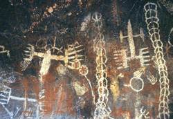
Burro Flats Painted Cave |
|
000000001976-05-05-0000May 5, 1976
(#76000539) |
Address Restricted
|
Bell Canyon |
A Cave containing Chumash pictographs near the historic Chumash settlement of Hu'wam along upper Bell Creek
|
| 7 |
Calleguas Creek Site |
Upload image |
000000001976-05-19-0000May 19, 1976
(#76000538) |
Address Restricted
|
Oxnard |
|
| 8 |
Camarillo Ranch House |
|
000000002003-02-20-0000February 20, 2003
(#03000039) |
201 Camarillo Ranch Rd.
34°13′05″N 119°01′02″W / 34.218056°N 119.017222°W / 34.218056; -119.017222 (Camarillo Ranch House) |
Camarillo |
Fifteen-room house built in 1892 by the Camarillo family, after whom the City of Camarillo is named
|
| 9 |
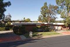
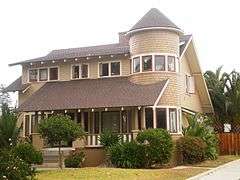
Case Study House No. 28 |
|
000000002013-07-24-0000July 24, 2013
(#13000522) |
91 Inverness Rd.
34°10′18″N 118°52′48″W / 34.171539°N 118.880119°W / 34.171539; -118.880119 (Case Study House No. 28) |
Thousand Oaks |
Case Study House by Buff and Hensman, built 1966
|
| 10 |
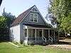
Colony House |
|
000000001978-09-18-0000September 18, 1978
(#78000824) |
137 Strathearn Pl.
34°16′30″N 118°48′04″W / 34.275°N 118.801111°W / 34.275; -118.801111 (Colony House) |
Simi Valley |
Kit house on display at historical park with Simi Adobe and Strathearn House
|
| 11 |
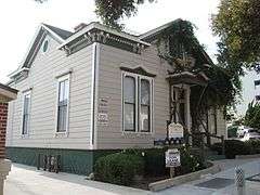
Dudley House |
|
000000001977-05-12-0000May 12, 1977
(#77000362) |
4085 Telegraph Rd.
34°16′34″N 119°14′20″W / 34.276111°N 119.238889°W / 34.276111; -119.238889 (Dudley House) |
Ventura |
|
| 12 |
Ebell Club of Santa Paula |
|
000000001989-07-20-0000July 20, 1989
(#89000949) |
125 S. Seventh St.
34°21′06″N 119°03′51″W / 34.351667°N 119.064167°W / 34.351667; -119.064167 (Ebell Club of Santa Paula) |
Santa Paula |
|
| 13 |
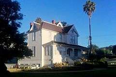
George Washington Faulkner House |
|
000000001991-04-25-0000April 25, 1991
(#91000485) |
14292 W. Telegraph Rd.
34°19′32″N 119°06′18″W / 34.325556°N 119.105°W / 34.325556; -119.105 (George Washington Faulkner House) |
Santa Paula |
|
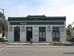
| 14 |
Feraud General Merchandise Store |
|
000000001986-01-23-0000January 23, 1986
(#86000109) |
2 and 12 W. Main St.
34°16′51″N 119°18′03″W / 34.280833°N 119.300972°W / 34.280833; -119.300972 (Feraud General Merchandise Store) |
Ventura |
Historic bakery, now a bar
|
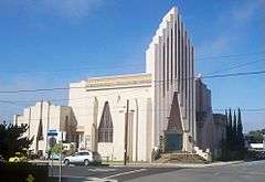
| 15 |
First Baptist Church of Ventura |
|
000000002009-07-03-0000July 3, 2009
(#09000466) |
101 S. Laurel St.
34°16′46″N 119°17′09″W / 34.279311°N 119.285714°W / 34.279311; -119.285714 (First Baptist Church of Ventura) |
Ventura |
|
| 16 |
Emmanuel Franz House |
|
000000001982-06-25-0000June 25, 1982
(#82002282) |
31 N. Oak St.
34°16′52″N 119°17′38″W / 34.281111°N 119.293889°W / 34.281111; -119.293889 (Emmanuel Franz House) |
Ventura |
|
| 17 |
Glen Tavern Hotel |
|
000000001984-07-26-0000July 26, 1984
(#84001225) |
134 N. Mill St.
34°21′18″N 119°03′40″W / 34.355°N 119.061111°W / 34.355; -119.061111 (Glen Tavern Hotel) |
Santa Paula |
|
| 18 |
Thomas Gould, Jr. House |
Upload image |
000000002005-12-23-0000December 23, 2005
(#05001426) |
402 Lynn Dr.
34°16′47″N 119°14′58″W / 34.279722°N 119.249444°W / 34.279722; -119.249444 (Thomas Gould, Jr. House) |
Ventura |
|
| 19 |
Grand Union Hotel |
|
000000001975-12-30-0000December 30, 1975
(#75000495) |
51 Ventu Park Rd.
34°10′41″N 118°54′41″W / 34.178056°N 118.911389°W / 34.178056; -118.911389 (Grand Union Hotel) |
Newbury Park |
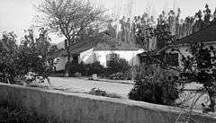
Originally built in 1876, the structure was destroyed by fire in 1970. It was rebuilt and opened in 1976 as a historical museum, known in recent years as the Stagecoach Inn.
|
| 20 |
Grandma Prisbrey's Bottle Village |
|
000000001996-10-25-0000October 25, 1996
(#96001076) |
4595 Cochran St.
34°16′44″N 118°42′14″W / 34.278889°N 118.703889°W / 34.278889; -118.703889 (Grandma Prisbrey's Bottle Village) |
Simi Valley |
Folk art assemblage made out of bottles and other found objects begun in 1956 by Tressa Prisbrey
|
| 21 |
Joel McCrea Ranch |
|
000000001997-04-18-0000April 18, 1997
(#97000295) |
4500 N. Moorpark Rd.
34°14′35″N 118°51′24″W / 34.243056°N 118.856667°W / 34.243056; -118.856667 (Joel McCrea Ranch) |
Thousand Oaks |
Working ranch run by actor Joel McCrea from the 1930s to the 1970s
|
| 22 |
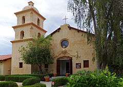
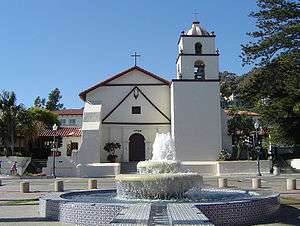
Mission San Buenaventura and Mission Compound Site |
|
000000001975-04-10-0000April 10, 1975
(#75000496) |
Bounded by Poli St., Ventura and Santa Clara Aves., and Palm St.
34°16′50″N 119°17′52″W / 34.280556°N 119.297778°W / 34.280556; -119.297778 (Mission San Buenaventura and Mission Compound Site) |
Ventura |
|
| 23 |
Olivas Adobe |
|
000000001979-07-24-0000July 24, 1979
(#79000570) |
4200 Olivas Park Dr.
34°14′40″N 119°14′28″W / 34.244444°N 119.241111°W / 34.244444; -119.241111 (Olivas Adobe) |
Ventura |
The only early two-story adobe in the Santa Clara River Valley; small one-story adobe built in 1837 was expanded in 1849 by Don Raimundo Olivas
|
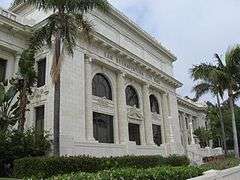
| 24 |
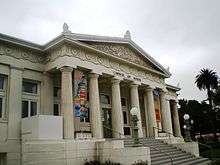
Oxnard Public Library |
|
000000001971-07-27-0000July 27, 1971
(#71000210) |
424 S. C St.
34°11′54″N 119°10′48″W / 34.198333°N 119.18°W / 34.198333; -119.18 (Oxnard Public Library) |
Oxnard |
Former Carnegie library converted into an art museum, now known as Carnegie Art Museum
|
| 25 |
Henry T. Oxnard Historic District |
|
000000001999-02-05-0000February 5, 1999
(#99000109) |
F and G Sts., between Palm and 5th Sts.
34°12′01″N 119°11′11″W / 34.200278°N 119.186389°W / 34.200278; -119.186389 (Henry T. Oxnard Historic District) |
Oxnard |
District of historic homes located near downtown Oxnard
|
| 26 |
Charles M. Pratt House |
|
000000002002-06-14-0000June 14, 2002
(#00001227) |
1330 Foothill Rd.
34°27′43″N 119°15′18″W / 34.461944°N 119.255°W / 34.461944; -119.255 (Charles M. Pratt House) |
Ojai |
|
| 27 |
Rancho Camulos |
|
000000001996-11-01-0000November 1, 1996
(#96001137) |
5164 E. Telegraph Rd.
34°24′18″N 118°45′20″W / 34.405°N 118.755556°W / 34.405; -118.755556 (Rancho Camulos) |
Piru |
|
| 28 |
St. Thomas Aquinas Chapel |
|
000000001995-06-29-0000June 29, 1995
(#95000785) |
130 W. Ojai Ave.
34°26′53″N 119°14′49″W / 34.448056°N 119.246944°W / 34.448056; -119.246944 (St. Thomas Aquinas Chapel) |
Ojai |
|
| 29 |
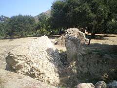
San Buenaventura Mission Aqueduct |
|
000000001975-03-07-0000March 7, 1975
(#75000497) |
234 Canada Larga Rd.
34°20′31″N 119°17′23″W / 34.341944°N 119.289722°W / 34.341944; -119.289722 (San Buenaventura Mission Aqueduct) |
Ventura |
Ruins of 7 mile (11 km) aqueduct built by Native Americans to bring water from the Ventura River to the San Buenaventura Mission
|
| 30 |
San Miguel Chapel Site |
|
000000001978-07-20-0000July 20, 1978
(#78000826) |
Thompson Blvd. and Palm St.[6]
34°16′41″N 119°17′48″W / 34.278033°N 119.296718°W / 34.278033; -119.296718 (San Miguel Chapel Site) |
Ventura |
|
| 31 |
Santa Paula Hardware Company Block-Union Oil Company |
|
000000001986-08-14-0000August 14, 1986
(#86002619) |
1003 E. Main St.
34°21′15″N 119°03′32″W / 34.354167°N 119.058889°W / 34.354167; -119.058889 (Santa Paula Hardware Company Block-Union Oil Company) |
Santa Paula |
|
| 32 |
Simi Adobe-Strathearn House |
|
000000001978-05-19-0000May 19, 1978
(#78000825) |
137 Strathearn Pl.
34°16′30″N 118°48′01″W / 34.275°N 118.800278°W / 34.275; -118.800278 (Simi Adobe-Strathearn House) |
Simi Valley |
Old adobe and Victorian house built in 1892 that were the homestead of the Ranch Simi
|
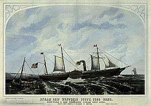
| 33 |
SS WINFIELD SCOTT (Steamship) |
|
000000001988-09-12-0000September 12, 1988
(#87002111) |
Address Restricted
|
Anacapa Island |
Shipwreck.
|
| 34 |
Ventura County Courthouse |
|
000000001971-08-19-0000August 19, 1971
(#71000211) |
501 Poli St.
34°16′57″N 119°17′32″W / 34.2825°N 119.292222°W / 34.2825; -119.292222 (Ventura County Courthouse) |
Ventura |
|
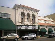
| 35 |
Ventura Theatre |
|
000000001986-12-29-0000December 29, 1986
(#86003523) |
26 S. Chestnut
34°16′50″N 119°17′26″W / 34.280556°N 119.290556°W / 34.280556; -119.290556 (Ventura Theatre) |
Ventura |
Historic theater now a popular music venue in downtown Ventura
|
| 36 |
Women's Improvement Club of Hueneme |
|
000000001989-08-21-0000August 21, 1989
(#89001150) |
239 E. Scott St.
34°08′58″N 119°11′48″W / 34.149444°N 119.196667°W / 34.149444; -119.196667 (Women's Improvement Club of Hueneme) |
Port Hueneme |
|

.jpg)
.jpg)
%2C_California_(NYDA.1987.003.00121).jpg)