United States primary statistical area
| Population tables of U.S. cities |
|---|
 |
| Cities |
| Urban areas |
| Populous cities and metropolitan areas |
| Metropolitan areas |
| Megaregions |
This article defines a "primary" metropolitan area as a metropolitan area that is not a component of a more extensive defined metropolitan area. A Core Based Statistical Area (defined by the United States Office of Management and Budget (OMB)[1]) that is not a component of a Combined Statistical Area (CSA)[2] is what is defined here as a "primary statistical area."
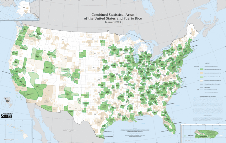
The 574 primary statistical areas (PSAs) of the United States and Puerto Rico comprise all 169 Combined Statistical Areas currently defined by the OMB and the 405 of 929 Core Based Statistical Areas (CBSAs)[3][4] currently defined by the OMB that are not a component of a Combined Statistical Area. On February 28, 2013, the United States Office of Management and Budget defined 1098 Statistical Areas for the United States and Puerto Rico, comprising 169 Combined Statistical Areas,[5] 388 Metropolitan Statistical Areas,[6] and 541 Micropolitan Statistical Areas[7] for the United States and Puerto Rico.[1] A total of 574 of these 1098 Statistical Areas qualify as primary statistical areas, including all 169 Combined Statistical Areas, 122 of the 388 Metropolitan Statistical Areas, and 283 of the 541 Micropolitan Statistical Areas. The OMB does not use the term "primary statistical area", but the term is commonly used to identify the most extensive OMB defined Statistical Area for a given county or county-equivalent.
Map
See also
- United States of America
- Outline of the United States
- Index of United States-related articles
- Book:United States
- Demographics of the United States
- United States Census Bureau
- United States Office of Management and Budget
- The OMB has defined 1098 statistical areas comprising 388 MSAs, 541 μSAs, and 169 CSAs
References
- 1 2 "OMB Bulletin No. 13-01: Revised Delineations of Metropolitan Statistical Areas, Micropolitan Statistical Areas, and Combined Statistical Areas, and Guidance on Uses of the Delineations of These Areas" (PDF). United States Office of Management and Budget. February 28, 2013. Retrieved April 1, 2013.
- ↑ The United States Office of Management and Budget (OMB) defines a Combined Statistical Area (CSA) as an aggregate of adjacent core based statistical areas that are linked by commuting ties.
- ↑ The United States Office of Management and Budget (OMB) defines a Core Based Statistical Area as one or more adjacent counties or county-equivalents having at least one urban cluster of at least 10,000 population, plus adjacent territory that has a high degree of social and economic integration with the core as measured by commuting ties.
- ↑ See the List of United States Core Based Statistical Areas.
- ↑ See the List of United States Combined Statistical Areas.
- ↑ See the List of United States Metropolitan Statistical Areas.
- ↑ See the List of United States Micropolitan Statistical Areas.