List of the major 4000-meter summits of California
The following sortable table comprises the 16 mountain peaks of the U.S. State of California with at least 4000 meters (13,123 feet) of topographic elevation and at least 500 meters (1640 feet) of topographic prominence.
Topographic elevation is the vertical distance above the reference geoid, a mathematical model of the Earth's sea level as an equipotential gravitational surface. The topographic prominence of a summit is the elevation difference between that summit and the highest or key col to a higher summit. The topographic isolation of a summit is the minimum great-circle distance to a point of equal elevation.
This article defines a significant summit as a summit with at least 100 meters (328.1 feet) of topographic prominence, and a major summit as a summit with at least 500 meters (1640 feet) of topographic prominence. An ultra-prominent summit is a summit with at least 1500 meters (4921 feet) of topographic prominence. There are 126 ultra-prominent summits in the United States.
All elevations include an adjustment from the National Geodetic Vertical Datum of 1929 (NGVD 29) to the North American Vertical Datum of 1988 (NAVD 88). For further information, please see this United States National Geodetic Survey note.
If an elevation or prominence is calculated as a range of values, the arithmetic mean is shown.
Major 4000-meter summits
Gallery
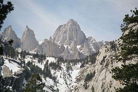
- 1. Mount Whitney is the highest summit of the Sierra Nevada, the State of California, and the contiguous United States.
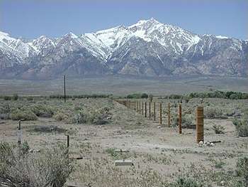 2. Mount Williamson is the second highest mountain peak of California.
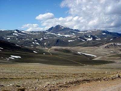 3. White Mountain Peak is the highest summit of the White Mountains.
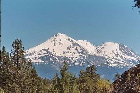 5. The stratovolcano Mount Shasta is the second most topographically prominent California mountain peak.
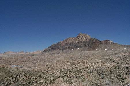 6. Mount Humphreys in the Sierra Nevada.
 8. Mount Darwin is the highest summit of the Evolution Peaks of the Sierra Nevada.
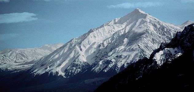 12. Mount Tom in the Sierra Nevada.
See also
- List of mountain peaks of North America
- List of mountain peaks of Greenland
- List of mountain peaks of Canada
- List of mountain peaks of the Rocky Mountains
- List of mountain peaks of the United States
- List of mountain peaks of Alaska
- List of mountain peaks of California
- List of the major 4000-meter summits of California
- List of the major 3000-meter summits of California
- List of California fourteeners
- List of mountain ranges of California
- List of mountain peaks of Colorado
- List of mountain peaks of Hawaiʻi
- List of mountain peaks of México
- List of mountain peaks of Central America
- List of mountain peaks of the Caribbean
- California
- Geography of California
- Category:Mountains of California
- Geography of California
- Physical geography
References
- ↑ The summit of Mount Whitney is the highest point of the Sierra Nevada, the State of California, and the contiguous United States.
- ↑ Mount Whitney is the southernmost and easternmost summit of its elevation in United States.
- ↑ "WHITNEY". Datasheet for NGS Station GT1811. United States National Geodetic Survey. Retrieved 18 May 2016.
- ↑ "Mount Whitney". Geographic Names Information System. United States Geological Survey.
- ↑ "Mount Whitney". Peakbagger.com. Retrieved 18 May 2016.
- ↑ "Mount Whitney". Bivouac.com. Retrieved 18 May 2016.
- ↑ "Mount Williamson". Geographic Names Information System. United States Geological Survey.
- ↑ The elevation of Mount Williamson includes an adjustment of +1.807 m (+5.93 ft) from NGVD 29 to NAVD 88.
- ↑ "Mount Williamson". Peakbagger.com. Retrieved 18 May 2016.
- ↑ "Mount Williamson". Bivouac.com. Retrieved 18 May 2016.
- ↑ The summit of White Mountain Peak is the highest point of the White Mountains.
- ↑ "WHITE MOUNTAIN PEAK". Datasheet for NGS Station HR2559. United States National Geodetic Survey. Retrieved 18 May 2016.
- ↑ "White Mountain Peak". Geographic Names Information System. United States Geological Survey.
- ↑ "White Mountain Peak". Peakbagger.com. Retrieved 18 May 2016.
- ↑ "White Mountain Peak". Bivouac.com. Retrieved 18 May 2016.
- ↑ The summit of North Palisade is the highest point of the Palisades.
- ↑ "NORTH PALISADE". Datasheet for NGS Station HR2629. United States National Geodetic Survey. Retrieved 18 May 2016.
- ↑ "North Palisade". Geographic Names Information System. United States Geological Survey.
- ↑ The elevation of North Palisade includes an adjustment of +1.867 m (+6.13 ft) from NGVD 29 to NAVD 88.
- ↑ "North Palisade". Peakbagger.com. Retrieved 18 May 2016.
- ↑ "North Palisade". Bivouac.com. Retrieved 18 May 2016.
- ↑ The summit of Mount Shasta is the highest point of the southern Cascade Range.
- ↑ "MT SHASTA". Datasheet for NGS Station MX1016. United States National Geodetic Survey. Retrieved 18 May 2016.
- ↑ "Mount Shasta". Geographic Names Information System. United States Geological Survey.
- ↑ "Mount Shasta". Peakbagger.com. Retrieved 18 May 2016.
- ↑ "Mount Shasta". Bivouac.com. Retrieved 18 May 2016.
- ↑ "MT HUMPHREYS". Datasheet for NGS Station HR2626. United States National Geodetic Survey. Retrieved 18 May 2016.
- ↑ "Mount Humphreys". Geographic Names Information System. United States Geological Survey.
- ↑ The elevation of Mount Humphreys includes an adjustment of +1.842 m (+6.04 ft) from NGVD 29 to NAVD 88.
- ↑ "Mount Humphreys". Peakbagger.com. Retrieved 18 May 2016.
- ↑ "Mount Humphreys". Bivouac.com. Retrieved 18 May 2016.
- ↑ "MT KEITH". Datasheet for NGS Station GT1807. United States National Geodetic Survey. Retrieved 18 May 2016.
- ↑ "Mount Keith". Geographic Names Information System. United States Geological Survey.
- ↑ The elevation of Mount Keith includes an adjustment of +1.795 m (+5.89 ft) from NGVD 29 to NAVD 88.
- ↑ "Mount Keith". Peakbagger.com. Retrieved 18 May 2016.
- ↑ "Mount Keith". Bivouac.com. Retrieved 18 May 2016.
- ↑ "MT DARWIN". Datasheet for NGS Station HR2631. United States National Geodetic Survey. Retrieved 18 May 2016.
- ↑ "Mount Darwin". Geographic Names Information System. United States Geological Survey.
- ↑ The elevation of Mount Darwin includes an adjustment of +1.886 m (+6.19 ft) from NGVD 29 to NAVD 88.
- ↑ "Mount Darwin". Peakbagger.com. Retrieved 18 May 2016.
- ↑ "Mount Darwin". Bivouac.com. Retrieved 18 May 2016.
- ↑ The summit of Mount Kaweah is the highest point of the Great Western Divide.
- ↑ Mount Kaweah is the southernmost summit of its elevation in United States.
- ↑ "Mount Kaweah". Geographic Names Information System. United States Geological Survey.
- ↑ The elevation of Mount Kaweah includes an adjustment of +1.652 m (+5.42 ft) from NGVD 29 to NAVD 88.
- ↑ "Mount Kaweah". Peakbagger.com. Retrieved 18 May 2016.
- ↑ "Mount Kaweah". Bivouac.com. Retrieved 18 May 2016.
- ↑ "MORGAN". Datasheet for NGS Station HR2627. United States National Geodetic Survey. Retrieved 18 May 2016.
- ↑ "Mount Morgan". Geographic Names Information System. United States Geological Survey.
- ↑ "Mount Morgan". Peakbagger.com. Retrieved 18 May 2016.
- ↑ "Mount Morgan". Bivouac.com. Retrieved 18 May 2016.
- ↑ "Mount Gabb". Geographic Names Information System. United States Geological Survey.
- ↑ The elevation of Mount Gabb includes an adjustment of +1.958 m (+6.42 ft) from NGVD 29 to NAVD 88.
- ↑ "Mount Gabb". Peakbagger.com. Retrieved 18 May 2016.
- ↑ "Mount Gabb". Bivouac.com. Retrieved 18 May 2016.
- ↑ "Mount Tom". Geographic Names Information System. United States Geological Survey.
- ↑ The elevation of Mount Tom includes an adjustment of +1.379 m (+4.52 ft) from NGVD 29 to NAVD 88.
- ↑ "Mount Tom". Peakbagger.com. Retrieved 18 May 2016.
- ↑ "Mount Tom". Bivouac.com. Retrieved 18 May 2016.
- ↑ "Mount Dubois". Geographic Names Information System. United States Geological Survey.
- ↑ The elevation of Mount Dubois includes an adjustment of +1.879 m (+6.16 ft) from NGVD 29 to NAVD 88.
- ↑ "Mount Dubois". Peakbagger.com. Retrieved 18 May 2016.
- ↑ "Mount Dubois". Bivouac.com. Retrieved 18 May 2016.
- ↑ "Mount Pinchot". Geographic Names Information System. United States Geological Survey.
- ↑ The elevation of Mount Pinchot includes an adjustment of +1.810 m (+5.94 ft) from NGVD 29 to NAVD 88.
- ↑ "Mount Pinchot". Peakbagger.com. Retrieved 18 May 2016.
- ↑ "Mount Pinchot". Bivouac.com. Retrieved 18 May 2016.
- ↑ The summit of Mount Ritter is the highest point of the Ritter Range.
- ↑ "Mount Ritter". Geographic Names Information System. United States Geological Survey.
- ↑ The elevation of Mount Ritter includes an adjustment of +1.786 m (+5.86 ft) from NGVD 29 to NAVD 88.
- ↑ "Mount Ritter". Peakbagger.com. Retrieved 18 May 2016.
- ↑ "Mount Ritter". Bivouac.com. Retrieved 18 May 2016.
- ↑ "RED SLATE MOUNTAIN". Datasheet for NGS Station HR2690. United States National Geodetic Survey. Retrieved 18 May 2016.
- ↑ "Red Slate Mountain". Geographic Names Information System. United States Geological Survey.
- ↑ The elevation of Red Slate Mountain includes an adjustment of +1.893 m (+6.21 ft) from NGVD 29 to NAVD 88.
- ↑ "Red Slate Mountain". Peakbagger.com. Retrieved 18 May 2016.
External links
- National Geodetic Survey (NGS)
- United States Geological Survey (USGS)
- peakbagger
- peaklist.org
- summitpost.org
- World Mountain Encyclopedia @ peakware.com

Coordinates: 36°34′43″N 118°17′31″W / 36.5786°N 118.2920°W