Castle Peak (Colorado)
| Castle Peak | |
|---|---|
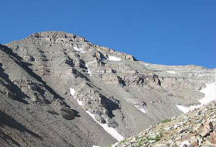 View from NNE above Montezuma Basin | |
| Highest point | |
| Elevation | 14,279 ft (4352.2 m) [1] NAVD88 |
| Prominence | 2365 ft (721 m) [2] |
| Isolation | 20.9 mi (33.6 km) [2] |
| Listing | |
| Coordinates | 39°00′35″N 106°51′41″W / 39.0097375°N 106.8613598°WCoordinates: 39°00′35″N 106°51′41″W / 39.0097375°N 106.8613598°W [1] |
| Geography | |
 Castle Peak | |
| Location | High point of both Gunnison and Pitkin counties, Colorado, U.S.[2] |
| Parent range |
Highest summit of the Elk Mountains[2] |
| Topo map |
USGS 7.5' topographic map Hayden Peak, Colorado[3] |
| Climbing | |
| First ascent | 1873 by the Hayden Survey |
| Easiest route | Hike/scramble |
Castle Peak is the ninth highest summit of the Rocky Mountains of North America and the U.S. state of Colorado. The prominent 14,279-foot (4352.2 m) fourteener is the highest summit of the Elk Mountains and the Maroon Bells-Snowmass Wilderness. The peak is located 11.6 miles (18.7 km) northeast by north (bearing 32°) of the Town of Crested Butte, Colorado, United States, on the drainage divide separating Gunnison National Forest and Gunnison County from White River National Forest and Pitkin County. The summit of Castle Peak is the highest point of both counties.[1][4][2][3]
Mountain
Castle Peak takes its name from its castellated summit.[5] The best climbing months are June, July, August, September through the Montezuma Glacier, a permanent snowfield between Castle and Conundrum Peaks. There are two standard routes for ascent. The Northwest Ridge features a moderate snow climb followed by an easy ridge scramble. It should not be attempted late in the summer when the 200 feet (60 m) of loose dirt and scree meet the climber near the top of the Castle-Conundrum saddle. The Northeast Ridge features an easy snow climb, but slightly harder scrambling and route-finding once on the ridge.
There are two other peaks in Colorado that have the same name: one in Eagle County at 39°46′23″N 106°50′04″W / 39.7730422°N 106.8344844°W,[6] with an elevation 11,280+ feet, (3438+ m);[7] and the other in Mesa County at 39°16′16″N 108°05′40″W / 39.2710898°N 108.0945204°W,[8] with an elevation of 8,140 feet (2,481 m).
Conundrum Peak is a northern subsummit of Castle Peak. It has two closely spaced summits; the northern is higher, with elevation of 14,040+ feet (4279+ m).[9] It is 0.4 miles (0.6 km) north of Castle Peak, and has 200 feet (61 m) of clean topographic prominence. This does not meet the usual 300-foot (91 m) prominence criterion for an officially separate peak; however, it is often climbed in conjunction with Castle Peak.[10]
See also
References
- 1 2 3 "CASTLE PK". NGS data sheet. U.S. National Geodetic Survey. Retrieved January 2, 2016.
- 1 2 3 4 5 "Castle Peak, Colorado". Peakbagger.com. Retrieved January 2, 2016.
- 1 2 "Castle Peak". Geographic Names Information System. United States Geological Survey. Retrieved November 14, 2014.
- ↑ The elevation of Castle Peak includes an adjustment of +2.165 m (+7.10 ft) from NGVD 29 to NAVD 88.
- ↑ Gannett, Henry (1905). The Origin of Certain Place Names in the United States. Govt. Print. Off.
- ↑ "Castle Peak". Geographic Names Information System. United States Geological Survey. Retrieved 2009-01-03.
- ↑ "Castle Peak, Colorado". Peakbagger.com. Retrieved 2009-01-03.
- ↑ "Castle Peak". Geographic Names Information System. United States Geological Survey. Retrieved 2009-01-03.
- ↑ "North Conundrum Peak, Colorado". Peakbagger.com. Retrieved 2009-01-03.
- ↑ Louis W. Dawson II, Dawson's Guide to Colorado's Fourteeners, Volume 1, Blue Clover Press, 1994, ISBN 0-9628867-1-8
External links
- "Castle Peak and Conundrum Peak". 14ers.com. Retrieved 2011-05-09.
- "Castle Peak". SummitPost.org.
- "Conundrum Peak". SummitPost.org.
- "Castle Peak / Conundrum Peak". Colorado Fourteeners. Retrieved 2011-05-09.
- "Castle Peak". Peakware. Retrieved 2011-05-09.
