Mount Washington (New Hampshire)
| Mount Washington | |
|---|---|
| Agiocochook | |
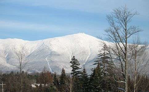 Mount Washington, from Bretton Woods. The cog railway track is visible, on the spur to the left of the summit. | |
| Highest point | |
| Elevation | 6,288 ft (1,917 m) NAVD 88[1] |
| Prominence | 6,148 ft (1,874 m) [2] |
| Listing | |
| Coordinates | 44°16′14″N 71°18′12″W / 44.270489039°N 71.303246453°WCoordinates: 44°16′14″N 71°18′12″W / 44.270489039°N 71.303246453°W [1] |
| Geography | |
 Mount Washington | |
| Location | Sargent's Purchase, Coös County, New Hampshire, U.S. |
| Parent range | Presidential Range |
| Topo map | USGS Mount Washington[3] |
| Climbing | |
| First ascent | 1642 (first recorded) |
| Easiest route | Hike, ride cog railway, or drive via Mount Washington Auto Road. |
Mount Washington, called Agiocochook by some Native American tribes, is the highest peak in the Northeastern United States at 6,288 ft (1,917 m) and the most prominent mountain east of the Mississippi River.
The mountain is notorious for its erratic weather. On the afternoon of April 12, 1934, the Mount Washington Observatory recorded a windspeed of 231 miles per hour (372 km/h) at the summit, the world record for most of the 20th century, and still a record for measured wind speeds not involved with a tropical cyclone.[4][lower-alpha 1]
The mountain is located in the Presidential Range of the White Mountains, in the township of Sargent's Purchase, Coös County, New Hampshire. While nearly the whole mountain is in the White Mountain National Forest, an area of 60.3 acres (24.4 ha) surrounding and including the summit is occupied by Mount Washington State Park.
The Mount Washington Cog Railway ascends the western slope of the mountain, and the Mount Washington Auto Road climbs to the summit from the east. The mountain is popular with hikers (the Appalachian Trail crosses the summit). Other common activities include glider flying, and annual cycle and running races such as the Auto Road Bicycle Hillclimb and Road Race.
Names
Before European settlers arrived in the region, the mountain was known by various indigenous peoples as Kodaak Wadjo ("the top is so hidden" or "summit of the highest mountain") or Agiochook or Agiocochook ("the place of the Great Spirit" or "the place of the Concealed One").[6] The Algonquians called it Waumbik, "white rocks".[6]
History
The first European to mention the mountain was Giovanni da Verrazzano. Viewing it from the Atlantic Ocean in 1524, he described what he saw as "high interior mountains."[7] The Abenaki people inhabiting the region at the time of European contact believed that the tops of mountains were the dwelling place of the gods, and so among other reasons did not climb them out of religious deference to their sanctity.[8] Darby Field claimed to have made the first ascent of Mt. Washington in 1642.[9] Field climbed the mountain in June of that year to demonstrate to the Abenaki chief Passaconaway that the Europeans bargaining for tribal land were not subject to the gods believed to inhabit the summit, a primarily political move that facilitated colonists' northern expansion.[8] Field again summited Agiocochook in October 1642 on an early surveying expedition that created maps of land as far as Maine, maps which assisted the delegations from the Massachusetts colony seeking to acquire the more arable coastal regions.[8]
A geology party, headed by Manasseh Cutler, named the mountain in 1784.[10] The Crawford Path, the oldest mountain hiking trail in the United States, was laid out in 1819 as a bridle path from Crawford Notch to the summit and has been in use ever since. Ethan Allen Crawford built a house on the summit in 1821, which lasted until a storm in 1826.[10]

Little occurred on the summit itself until the mid-19th century, when it was developed into one of the first tourist destinations in the nation, with construction of more bridle paths and two hotels. The Summit House opened in 1852, a 64-foot-long (20 m) stone hotel anchored by four heavy chains over its roof. In 1853, the Tip-Top House was erected to compete. Rebuilt of wood with 91 rooms in 1872–1873, the Summit House burned in 1908, then was replaced in granite in 1915.[10] The Tip-Top House alone survived the fire; today it is a state historic site, recently renovated for exhibits. Other Victorian era tourist attractions include a coach road (1861)—now the Mount Washington Auto Road—and the Mount Washington Cog Railway (1869), both of which are still in operation.[11]
For forty years, an intermittent daily newspaper, called Among the Clouds, was published by Henry M. Burt at the summit each summer, until 1917.[12][13]
In November 2010, it was revealed that Orlando, Florida-based CNL Financial Group, which owns the Mount Washington Hotel at the foot of the mountain, had formally filed to trademark the "Mount Washington" name. CNL officials said they were directing their efforts against other hotels that use the mountain's name and not the numerous businesses in the area that use it.[14][15] CNL's application at the U.S. Patent and Trademark Office seeks registration of the trademark "Mount Washington" for any retail service, any restaurant service, and any entertainment service.[16]
Climate
| Mount Washington | ||||||||||||||||||||||||||||||||||||||||||||||||||||||||||||
|---|---|---|---|---|---|---|---|---|---|---|---|---|---|---|---|---|---|---|---|---|---|---|---|---|---|---|---|---|---|---|---|---|---|---|---|---|---|---|---|---|---|---|---|---|---|---|---|---|---|---|---|---|---|---|---|---|---|---|---|---|
| Climate chart (explanation) | ||||||||||||||||||||||||||||||||||||||||||||||||||||||||||||
| ||||||||||||||||||||||||||||||||||||||||||||||||||||||||||||
| ||||||||||||||||||||||||||||||||||||||||||||||||||||||||||||
The summit station of Mount Washington has an alpine climate or tundra climate (Köppen ET), although it receives an extremely high amount of precipitation, atypical for most regions with such cold weather. Lower elevations have a subarctic climate (Köppen Dfc).[18]
The weather of Mount Washington is notoriously erratic. This is partly due to the convergence of several storm tracks, mainly from the Atlantic to the south, the Gulf region and the Pacific Northwest. The vertical rise of the Presidential Range, combined with its north-south orientation, makes it a significant barrier to westerly winds. Low-pressure areas are more favorable to develop along the coastline in the winter due to the relative temperature differences between the Northeastern United States and the Atlantic Ocean. With these factors combined, hurricane-force wind gusts are observed from the summit of the mountain on average of 110 days per year.[19]
Mount Washington once held the world record and still holds the Northern Hemisphere and Western Hemisphere record for directly measured surface wind speed, at 231 mph (372 km/h), recorded on the afternoon of April 12, 1934. A new wind speed record was discovered in 2009: on April 10, 1996, Tropical Cyclone Olivia had created a wind gust of 408 km/h (254 mph) at Barrow Island off the coast of Western Australia.[20] (Satellite and radar measurements, e.g. of tornadoes, hurricanes, and air currents in the upper atmosphere, do not compete with records for surface measurements.)
The first regular meteorological observations on Mount Washington were conducted by the U.S. Signal Service, a precursor of the National Weather Service from 1870 to 1892. The Mount Washington station was the first of its kind in the world, setting an example followed in many other countries. For many years, the record low temperature was thought to be −47 °F (−44 °C) occurring on January 29, 1934, but upon the first in-depth examination of the data from the 19th century at NOAA's National Climatic Data Center in Asheville, North Carolina, a new record low was discovered. Mount Washington's official record low of −50 °F (−46 °C) was recorded on January 22, 1885. However, there is also hand-written evidence to suggest that an unofficial low of −59 °F (−51 °C) occurred on January 5, 1871. The official record cold daily maximum is −28 °F (−33 °C) on February 6, 1995.[17] Highs of 0 °F (−18 °C) or below occur on 13 days annually, while lows at or below 0 °F can be expected from November 17 through April 1; from December to March, temperatures rise above freezing on only 15 days.[17]
On January 16, 2004, the summit weather observation registered a temperature of −43.6 °F (−42.0 °C) and sustained winds of 87.5 mph (140.8 km/h), resulting in a wind chill value of −102.59 °F (−74.77 °C) at the mountain.[21] During a 71-hour period from approximately 3 p.m. on January 13 to 2 p.m. on January 16, 2004, the wind chill on the summit never went above −50 °F (−46 °C).[21] The official record high temperature at the summit is 72 °F (22 °C) on June 26, 2003, and August 2, 1975.[22] while the official record warm daily minimum is 60 °F (16 °C) on the latter date.[17] Readings of 60 °F or more at the summit are seen on an average 13.5 days annually.[23]
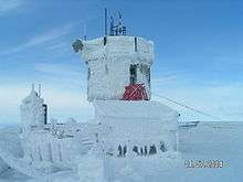
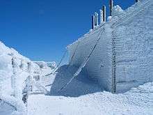
The primary summit building was designed to withstand 300 mph (480 km/h) winds; other structures are chained to the mountain.[24] In addition to a number of broadcast towers, the mountain is the site of a non-profit scientific observatory reporting the weather as well as other aspects of the subarctic climate of the mountain. The extreme environment creates strong winds and ice at the top of Mount Washington making the use of unmanned equipment problematic. The observatory also conducts research, primarily the testing of new weather measurement devices. The Sherman Adams summit building, which houses the observatory, is closed to the public during the winter[25] and hikers are not allowed inside the building except for emergencies and pre-arranged guided tours.[26]

The Mount Washington Observatory was built on the summit in 1932 through a group interested in and noting the worth of a research facility at that demanding location.[27] The observatory's weather data have accumulated a climate record since. Temperature and humidity readings have been collected using a sling psychrometer, a simple device containing two mercury thermometers. Where most unstaffed weather stations have undergone technology upgrades, consistent use of the sling psychrometer has helped provide scientific precision to the Mount Washington climate record.[28]
The observatory makes prominent use of the slogan "Home of the World's Worst Weather," a claim that originated with a 1940 article in the Appalachia magazine by Charles Brooks (the man generally given the majority of credit for creating the Mount Washington Observatory), titled "The Worst Weather in the World" (even though the article concluded that Mount Washington most likely did not have the world's worst weather).[26][29]
Precipitation
Due in part to its high prominence, to its situation at the confluence of two major storm tracks, and to the north-south orientation of the Presidential Range ridgeline which it crowns, Mount Washington receives very high levels of precipitation, averaging an equivalent of 96.9 in (2,460 mm) of rain per year,[lower-alpha 2] with a record high for a calendar year anywhere in the U.S. east of the Cascade mountains along the west coast [30] of 130.14 in (3,305.6 mm) in 1969 and a low of 71.34 in (1,812.0 mm) in 1979. Monthly precipitation has ranged from 0.75 in (19.1 mm) in October 1947 to 28.70 in (729.0 mm) in October 2005.[22] Large amounts of precipitation often fall in a short period of time: in October 1996, a record 11.07 in (281.2 mm) of precipitation fell during a single 24-hour period. A substantial amount of this falls as snow, with a seasonal[lower-alpha 3] average of around 280 inches (7.1 m) of snow; seasonal accumulation has ranged from 75.8 in (1.93 m) in 1947–48 to 566.4 in (14.39 m) in 1968–69.[17] The record amount of snowfall in a 24-hour period, 49.3 in (125.2 cm), occurred in February 1969, which is also the snowiest month on record with 172.8 in (4.39 m).[22]
| Climate data for Mount Washington, elev. 6,267 ft (1,910.2 m) near the summit | |||||||||||||
|---|---|---|---|---|---|---|---|---|---|---|---|---|---|
| Month | Jan | Feb | Mar | Apr | May | Jun | Jul | Aug | Sep | Oct | Nov | Dec | Year |
| Record high °F (°C) | 48 (9) |
43 (6) |
54 (12) |
60 (16) |
66 (19) |
72 (22) |
71 (22) |
72 (22) |
69 (21) |
62 (17) |
52 (11) |
47 (8) |
72 (22) |
| Average high °F (°C) | 13.6 (−10.2) |
14.7 (−9.6) |
20.7 (−6.3) |
30.4 (−0.9) |
41.3 (5.2) |
50.4 (10.2) |
54.1 (12.3) |
53.3 (11.8) |
47.1 (8.4) |
36.4 (2.4) |
28.1 (−2.2) |
18.4 (−7.6) |
34.0 (1.1) |
| Daily mean °F (°C) | 4.8 (−15.1) |
6.2 (−14.3) |
12.9 (−10.6) |
23.9 (−4.5) |
35.6 (2) |
45.0 (7.2) |
49.1 (9.5) |
48.2 (9) |
41.6 (5.3) |
30.2 (−1) |
20.7 (−6.3) |
10.1 (−12.2) |
27.36 (−2.58) |
| Average low °F (°C) | −4.1 (−20.1) |
−2.4 (−19.1) |
5.0 (−15) |
17.4 (−8.1) |
29.8 (−1.2) |
39.5 (4.2) |
44.0 (6.7) |
43.0 (6.1) |
36.1 (2.3) |
24.0 (−4.4) |
13.3 (−10.4) |
1.7 (−16.8) |
20.6 (−6.3) |
| Record low °F (°C) | −47 (−44) |
−46 (−43) |
−38 (−39) |
−20 (−29) |
−2 (−19) |
8 (−13) |
24 (−4) |
20 (−7) |
9 (−13) |
−5 (−21) |
−20 (−29) |
−46 (−43) |
−47 (−44) |
| Average precipitation inches (mm) | 6.44 (163.6) |
6.77 (172) |
7.67 (194.8) |
7.44 (189) |
8.18 (207.8) |
8.40 (213.4) |
8.77 (222.8) |
8.32 (211.3) |
8.03 (204) |
9.27 (235.5) |
9.85 (250.2) |
7.73 (196.3) |
96.87 (2,460.5) |
| Average snowfall inches (cm) | 44.0 (111.8) |
40.1 (101.9) |
45.1 (114.6) |
35.6 (90.4) |
12.2 (31) |
1.0 (2.5) |
trace | 0.1 (0.3) |
2.2 (5.6) |
17.6 (44.7) |
37.8 (96) |
45.5 (115.6) |
281.2 (714.2) |
| Average precipitation days (≥ 0.01 in) | 19.7 | 17.9 | 19.0 | 17.4 | 17.4 | 16.8 | 16.5 | 15.2 | 13.9 | 16.8 | 19.1 | 20.7 | 210.4 |
| Average snowy days (≥ 0.1 in) | 19.3 | 17.3 | 16.6 | 13.1 | 6.4 | 0.9 | 0.1 | 0.2 | 1.7 | 9.1 | 14.6 | 19.2 | 118.5 |
| Mean monthly sunshine hours | 92.0 | 106.9 | 127.6 | 143.2 | 171.3 | 151.3 | 145.0 | 130.5 | 127.2 | 127.1 | 82.4 | 83.1 | 1,487.6 |
| Percent possible sunshine | 32 | 36 | 34 | 35 | 37 | 33 | 31 | 30 | 34 | 37 | 29 | 30 | 33 |
| Source #1: NOAA (normals 1981–2010, sun 1961–1990)[17][23][31] | |||||||||||||
| Source #2: extremes 1933–present[22][32] | |||||||||||||
Geographical features
Although the western slope that the Cog Railway ascends is straightforward from base to summit, the mountain's other sides are more complex. On the north side, Great Gulf—the mountain's largest glacial cirque—forms an amphitheater surrounded by the Northern Presidentials: Mounts Clay, Jefferson, Adams and Madison.[13] These connected peaks reach well into the treeless alpine zone. Massive Chandler Ridge extends northeast from the summit of Washington to form the amphitheater's southern wall and the incline is ascended by the Mount Washington Auto Road.[13]

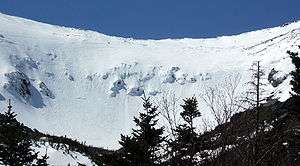
East of the summit, a plateau known as the Alpine Gardens extends south from Chandler Ridge at about 5,200 feet (1,600 m) elevation. It is notable for plant species either endemic to alpine meadows in the White Mountains or outliers of larger populations in arctic regions far to the north.[33] Alpine Gardens drops off precipitously into two prominent glacial cirques. Craggy Huntington Ravine offers rock and ice climbing in an alpine setting. More rounded Tuckerman Ravine is New England's premier venue for spring back-country skiing as late as June and then a scenic hiking route.[34]
South of the summit lies a second and larger alpine plateau, Bigelow Lawn,[35] at 5,000 feet (1,500 m) to 5,500 feet (1,700 m) elevation. Satellite summit Boott Spur and then the Montalban Ridge including Mount Isolation and Mount Davis extend south from it, while the higher Southern Presidentials—Mounts Monroe, Franklin, Eisenhower, Pierce, Jackson and Webster—extend southwest to Crawford Notch. Oakes Gulf separates the two high ridges.
Uses
The mountain is part of a popular hiking area, with the Appalachian Trail crossing the summit and one of the Appalachian Mountain Club's eight mountain huts, the Lakes of the Clouds Hut, located on one of the mountain's shoulders. Winter recreation includes Tuckerman Ravine, famous for its Memorial Day skiing and its 45-degree slopes. The ravine is notorious for its avalanches, of which about 100 are recorded every year, and which have killed six people since 1849. Scores of hikers have died on the mountain[36] in all seasons, due to harsh and rapidly changing conditions, inadequate equipment, and failure to plan for the wide variety of conditions which can occur above tree line.[37]
The weather at Mount Washington has made it a popular site for glider flying. In 2005, it was recognized as the 14th National Landmark of Soaring.[38]
Hiking


The most popular hiking trail approach to the summit is via the 4.1-mile (6.6 km) Tuckerman Ravine Trail. It starts at the Pinkham Notch camp area and gains 4,280 feet (1,300 m), leading straight up the bowl of Tuckerman Ravine[39] via a series of steep rock steps which afford spectacular views of the ravine and across the notch to Wildcat Mountain. Fatalities have occurred on the trail, both from ski accidents and hypothermia. Water bottles may be refilled at the base of the bowl 2.1 miles (3.4 km) up the trail at a well pump near a small hiker's store which offers snacks, toilets and shelter. At the summit is a center with a museum, gift shop, observation area, and cafeteria. Other routes up the eastern slopes of the mountain include the Lion Head, Boott Spur, Huntington Ravine and Nelson Crag trails, as well as the Great Gulf Trail ascending from the northeast. Routes from the western slopes include the Ammonoosuc Ravine and Jewell trails and the Crawford Path and Gulfside Trail (coincident with the Appalachian Trail from the southwest and from the north, respectively).[40]
There are many differences between climbing Mount Washington in summer and climbing it in winter. There are no public facilities on the summit in winter.[41] In the winter months, the most popular route is the Lion Head Winter Route, which begins on the Tuckerman Ravine Trail but then turns north to ascend up to Lion Head at elevation 5,033 feet (1,534 m). The winter route variation is recommended to help climbers avoid avalanche danger.[42] Exactly where the route turns from the Tuckerman Ravine Trail depends on the snow conditions. If the amount of snowfall has not been significant, the Lion Head Summer Route may be open. After hiking 2.3 miles (3.7 km) from the visitor center in Pinkham Notch, the trail will take a right turn onto the Lion Head Summer Route. If there has been enough snow accumulation on the summer Lion Head Trail, the Forest Service will open the Lion Head Winter Route, which turns off after approximately 1.7 miles (2.7 km).[42]
Cog railway
Since 1869, the Mount Washington Cog Railway has provided tourists with a train journey to the summit of Mount Washington.[43] It uses a Marsh rack system and was the first successful rack railway in the US.[44]
Races
Every June, the mountain is the site of the Mount Washington Road Race, an event which attracts hundreds of runners. In August the Mount Washington Auto Road Bicycle Hillclimb, a bicycle race, takes place along the same route as the road race.[45] The hillclimb's notable contestants include former Tour de France contender Tyler Hamilton.[46]
On August 7, 1932, Raymond E. Welch became the first one-legged man to climb Mount Washington.[47] An official race was held and open only to one-legged people. Mr. Welch climbed the "Jacob's Ladder" route and descended via the carriage road. At the time of his climb, he was the station agent for the Boston & Maine Railroad in Northumberland, New Hampshire.[47]
The mountain is also the host to one of the oldest car races in the country, the Mount Washington Hillclimb Auto Race, which has been held on and off since 1904. In September 2010, Travis Pastrana set an unofficial record at 6 minutes, 20.47 seconds, driving a Vermont sports car Subaru WRX STi.[48] In June 2014, David Higgins set a new record for ascent of Mt. Washington in a car, at 6:09.09 with an average speed of 75 mph, using the same model vehicle.[49]
Transmission stations
Edwin H. Armstrong installed an FM-broadcasting station on the top of Mount Washington in 1937. The station included the original broadcast tower, the Yankee Building, which housed the crew and transmitter equipment, and the first power house building. The station stopped operating in 1948, due to excessive maintenance costs. The original Armstrong tower still stands today. The Yankee Building also remains and continues to serve as a communications facility, housing equipment for numerous tenants including cellular telephone providers and public safety agencies. The only building no longer standing from Armstrong's original station is the original power house which was destroyed by fire in 2003 when a fire spread to it that had started in a neighboring building. In 1954 a TV tower and transmitters were installed for WMTW, Channel 8, licensed to Poland Spring, Maine. The station continuously broadcast until 2002 from the top of the mountain, including local forecasts by (now retired) WMTW transmitter engineer Marty Engstrom.[50]
Mount Washington continued FM broadcasting in 1958 with the construction of WMTW-FM 94.9, which became WHOM in 1976. WHOM and WMTW-TV shared a transmitter building, which also housed the generators to supply power to the mountain. A second radio station moved to the summit in 1987. WPKQ-FM (then known as WMOU) installed its transmitters in the Yankee building and constructed a new broadcast tower behind the building which is the tallest structure on the summit. On February 9, 2003, a fire broke out in the generator room of the WMTW/WHOM transmitter building, which had become the property of the state only a year earlier when WMTW left the summit. Though WMTW had left, the building at the time still had WHOM's transmitters inside it. The fire destroyed the building, including WHOM's transmitters, as well as the summit's main generators, and also spread to the adjacent Old Yankee Power House building which housed the emergency generator, destroying that building also and disrupting all power to the summit. Temporary generators had to be transported up the mountain to restore power to the observatory and to the Yankee building, which houses important public safety communications equipment. A makeshift generator room was constructed underneath the canopy of the Sherman Adams building across from the public entrance to replace the destroyed buildings. The makeshift generator room was later made permanent when power cables were installed in 2009, delivering grid power to the summit for the first time. The old sign from the destroyed Old Yankee Power House building was placed above the doorway to the new generator room. WHOM subsequently built a new transmitter building on the site of the old power building, and also constructed a new standby antenna on the Armstrong tower. (For the first time since 1948, the Armstrong tower was used for broadcasts.)[51]
The National Weather Service forecast office in Gray, Maine, operates NOAA Weather Radio station KZZ41 on 162.5 MHz from the summit of Mount Washington. Due to its point as the highest elevation in the Northeast and the frequency range NWR broadcasts on, the station can be heard at very far distances. It has been heard in northwest Vermont (at Vergennes), much of western Maine, and northern Massachusetts (at Dracut and Salisbury, the latter of which had clear reception). Based on the official NWS coverage area map, it can be heard clearly throughout most of New Hampshire, western Maine, northeast Vermont, and portions of southern Canada.[52] During very clear conditions, KZZ41 has the potential to reach the majority of northern Massachusetts (including some northern areas of Greater Boston and much of the North Shore) as well as the majority of Vermont and Maine.[52]
In June 2008, the possibility of television returning to Mount Washington came to light, with the filing by New Hampshire Public Television to move WLED-TV from its current location near Littleton to the old WMTW mast on top.[53][54]
Deaths
Since 1849, nearly 150 people have died on Mount Washington.[36] Author Nicholas Howe has detailed many of the fatalities on this mountain in his book Not Without Peril published in 2000 and updated in 2009.[55] The foreword to the 2009 edition states that many of the deaths over the past 150 years can be attributed to poor planning and lack of understanding of "the difference in weather between Boston and the mountains. The latter are farther north, farther inland and much higher than the city." William Buckingham Curtis, often called "the father of American amateur athletics" after his death, died from exhaustion on June 30, 1900, during a snowstorm near Lakes of the Clouds Hut.[56]
Artistic tributes

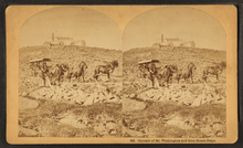
Mount Washington has been the subject of several famous paintings, part of a New England school of art known as White Mountain art.[57] Inspired by the Hudson River School of landscape painting, a number of artists during the Victorian era ventured into the White Mountains in search of natural subjects.[58] Train service in the area spurred increased tourism and the construction of the Glen House where Albert Bierstadt and his photographer brother (Bierstadt Brothers) stayed. John P. Soule,[59] John B. Heywood[60] and the Kilburn Brothers[61] also produced stereographic images of scenery in the area.
 Ferdinand Richardt (1857)
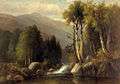
.jpg) John F. Kensett (1869)
John F. Kensett (1869) Albert Bierstadt (1858)
See also
Notes
- ↑ The current record gust of 254 miles per hour (409 km/h) was measured at Barrow Island, Australia, on October 4, 1996 (verified in 2010).[5]
- ↑ Measurable (0.1 in or 2.5 mm) precipitation occurs on an average 210 days annually, with 26 of those days seeing 1 in or 25 mm or more.
- ↑ July 1 through June 30 of the following calendar year
References
- 1 2 "Mount Washington". NGS data sheet. U.S. National Geodetic Survey. Retrieved 23 February 2009.
- ↑ "Mount Washington, New Hampshire". Peakbagger.com. Retrieved 16 February 2014.
- ↑ "Mount Washington". Geographic Names Information System. United States Geological Survey. Retrieved 28 November 2008.
- ↑ "World Record Wind". Mount Washington Observatory. Retrieved 7 March 2016.
- ↑ "World: Maximum Surface Wind Gust (3-Second)". World Weather / Climate Extremes Archive, Arizona State University.
- 1 2 The Indian Heritage of New Hampshire and Northern New England (ed. Thaddeus Piotrowski), McFarland & Company: 2002, p. 182.
- ↑ Ford, Daniel (2010). The Country Northward: A Hiker's Journal, on the Trail in the White Mountains of New Hampshire. p. 111. ISBN 978-1-4528-3092-6.
- 1 2 3 Howe, Nicholas (2009). Not WIthout Peril: 150 Years of Misadventure on the Presidential Range of New Hampshire. Guilford, Connecticut: Appalachian Mountain Club. p. 2. ISBN 978-1-934028-32-2.
- ↑ Johnson, Christopher (2006). This Grand & Magnificent Place: The Wilderness Heritage of the White Mountains. UPNE. p. 22. ISBN 978-1-58465-461-2.
- 1 2 3 Condensed Facts About Mount Washington, Atkinson News Co., 1912.
- ↑ Mount Washington: A Handbook for Travellers. Illustrated by Frank Hunt Burt (3rd ed.). G. H. Ellis Company. 1906. Retrieved 13 November 2010.
- ↑ "About Among the clouds. (Mount Washington, N.H.) 1885–1917". Chronicling America. Library of Congress. Retrieved 12 February 2015.
- 1 2 3 Heald, Bruce D. (2011). The Mount Washington Cog Railway: Climbing the White Mountains of New Hampshire. The History Press. p. 74. ISBN 978-1-60949-196-3.
- ↑ "Battle Brews Over Attempt To Trademark 'Mount Washington'". WMUR-TV, Manchester. November 11, 2010. Retrieved 13 November 2010.
- ↑ "Hotel Owners Say Concerns Over Mount Washington Name Overblown". WMUR-TV, Manchester. November 12, 2010. Retrieved 13 November 2010.
- ↑ U.S. Trademark Applications Serial Nos. 7669738, 76690735 and 76690740
- 1 2 3 4 5 6 "NOWData – NOAA Online Weather Data". National Oceanic and Atmospheric Administration. Retrieved June 19, 2013.
- ↑ "Mount Washington Observatory: Distance Learning". Mount Washington Observatory. Retrieved 13 November 2010.
- ↑ "Weather". Mount Washington Avalanche Center. Retrieved 12 February 2015.
- ↑ "Info note No.58 — World Record Wind Gust: 408 km/h". World Meteorological Association. 22 January 2010.
- 1 2 "History for Mt. Washington, NH". Weather Underground. Retrieved 8 March 2008.
- 1 2 3 4 "Mount Washington Observatory: Normals, Means and Extreme". Mount Washington Observatory. Retrieved 7 August 2010.
- 1 2 "Station Name: NH MT WASHINGTON". National Oceanic and Atmospheric Administration. Retrieved 9 June 2014.
- ↑ "Nature Phenomenon". Backpacker: 46. April 2007.
- ↑ "Mount Washington State Park". The New Hampshire Division of Parks and Recreation. Retrieved 12 February 2015.
- 1 2 Smith, Alan A. (September 1982). "The Mount Washington Weather Observatory - 50 Years Old". Bulletin of the American Meteorological Society. 63 (9). Retrieved March 29, 2016.
- ↑ Heald, Bruce D. (2011). The Mount Washington Cog Railway: Climbing the White Mountains of New Hampshire. The History Press. p. 72. ISBN 978-1-60949-196-3.
- ↑ Briede, Cyrena-Marie. "Product Testing and Research Capabilities with Mount Washington Observatory" (PDF). Mount Washington Observatory. Retrieved 18 March 2016.
- ↑ Brooks, Charles F. (1940). "The worst weather in the world". Appalachia: 194–202.
- ↑ "Record Maximum Annual Precipitation by State (thru 1998)" (PDF). NOAA National Centers for Environmental Information. Retrieved March 29, 2016.
- ↑ "WMO Climate Normals for MOUNT WASHINGTON, NH 1961–1990". National Oceanic and Atmospheric Administration. Retrieved 9 June 2014.
- ↑ "Today's Weather atop Mount Washington". Mount Washington Observatory. 14 January 2013. Archived from the original on 14 January 2013.
- ↑ "Alpine Garden: Alpine Zone". Division of Forests and Lands. Retrieved March 29, 2016.
- ↑ "History of Skiing in Tuckerman Ravine". Tuckerman Ravines. Archived from the original on 17 March 2007. Retrieved 28 March 2016.
- ↑ "Presidential Range". Peakbagger.com. Retrieved 12 February 2015.
- 1 2 Steiner, Christopher (6 April 2009). "Quiet Monster". Forbes. Retrieved 12 February 2015.
- ↑ Daley, Jason; Wong, Melanie. "The 20 Most Dangerous Hikes". Outside Online.
- ↑ "Mount Washington, New Hampshire - No. 14". National Soaring Museum. Retrieved March 29, 2016.
- ↑ "A Day Hike in New Hampshire's White Mountains". White Mountain Explorer. Retrieved 28 March 2016.
- ↑ "Skurka's Top Ten Favorite Hikes —Short (1 to 2 Days)". National Geographic Adventure Magazine.
- ↑ "Getting and Staying Here". Mount Washington Observatory. Retrieved March 29, 2016.
- 1 2 "Lion Head Winter Route, Mount Washington". The Peak Seeker. Retrieved March 29, 2016.
- ↑ Heald, Bruce D. (2011). The Mount Washington Cog Railway: Climbing the White Mountains of New Hampshire. The History Press. p. 8. ISBN 978-1-60949-196-3.
- ↑ "Sylvester Marsh and the Mount Washington Cog Railway". Retrieved 28 March 2016.
- ↑ Heald, Bruce D. (2011). The Mount Washington Cog Railway: Climbing the White Mountains of New Hampshire. The History Press. p. 27. ISBN 978-1-60949-196-3.
- ↑ "History". Newton's Revenge. Retrieved 28 March 2016.
- 1 2 "Raymond Edward Welch" (PDF). Coös County GenWeb. Retrieved 28 March 2016.
- ↑ Glucker, Jeff (10 September 2010). "Travis Pastrana smashes 12-year-old Mt. Washington Auto Road record". AutoBlog. Retrieved 28 March 2016.
- ↑ Flierl, Denis (30 June 2014). "Subaru WRX STI wins and smashes course record at Mt. Washington Hillclimb". Torque News. Retrieved 28 March 2016.
- ↑ Engstrom, Marty. Marty on the Mountain: 38 Years on Mt. Washington.
- ↑ "WMTW: fire on the mountain". GGN Information Systems. Retrieved 13 October 2008.
- 1 2 "KZZ41". National Weather Service. U.S. Department of Commerce/National Weather Service Gray, ME. Retrieved 12 February 2015.
- ↑ "Application for Construction Permit for Reserved Channel Noncommercial Educational Broadcast Station". U.S. Federal Communications Commission (FCC). June 20, 2008. Retrieved 13 October 2008.
- ↑ "Mount Washington, N.H.: A Look Back". Tower Site of the Week. fybush.com. 2003-02-20. Retrieved March 29, 2016.
- ↑ Globe Pequot Press, Guiford, Connecticut - ISBN 978-1-934028-32-2
- ↑ "The Life of an Athlete: William B. Curtis, the Father of American Amateur Athletics. The Tragic End of an Existence Filled with Much That Was Good and Healthful". The New York Times. July 8, 1900. Retrieved 6 January 2014.
By the tragic death of William B. Curtis in a blinding storm on Mount Washington about a week ago, the world of amateur sport has lost one of its most commanding figures ...
- ↑ "Mount Washington Gallery". White Mountain Art & Artists. Retrieved 28 March 2016.
- ↑ "Hudson River School - a taste for the landscape". The Art Wolf. Retrieved 28 March 2016.
- ↑ "Summit House Mount Washington, John P. Soule". Museum of the White Mountains. Plymouth State University.
- ↑ "Ledge and Mt. Adams Peak, from Mt. Washington Carriage Road". NYPL Digital Collections. Retrieved 28 March 2016.
- ↑ "New Hampshire Historical Society Features Cog Railway Historic Photos". Mount Washington Cog Railway. Retrieved 28 March 2016.
External links
- Mount Washington Observatory
- Mount Washington Cog Railway
- Mount Washington Auto Road
- Tips for hiking Mount Washington
- Current trail conditions on and around Mount Washington
- 19th-century paintings of Mount Washington
- Computer generated summit panoramas North South West to Adirondack Group Index
- National Geographic: Mount Washington – Backyard Arctic
- Hazecam view of Mount Washington