Mount Whitney
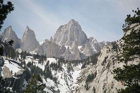


Mount Whitney is the highest summit in the contiguous United States and the Sierra Nevada, with an elevation of 14,505 feet (4421.0 m).[1] It is on the boundary between California's Inyo and Tulare counties, 84.6 miles (136.2 km) west-northwest of the lowest point in North America at Badwater in Death Valley National Park at 279 ft (85 m) below sea level.[8] The west slope of the mountain is in Sequoia National Park and the summit is the southern terminus of the John Muir Trail which runs 211.9 mi (341.0 km) from Happy Isles in Yosemite Valley.[9] The east slope is in the Inyo National Forest in Inyo County.
Geography

The summit of Whitney is on the Sierra Crest and the Great Basin Divide. It lies near many of the highest peaks of the Sierra Nevada.[10] The peak rises dramatically above the Owens Valley, sitting 10,778 feet (3,285 m) or just over two miles above the town of Lone Pine 15 miles to the east, in the Owens Valley.[10][10] It rises more gradually on the west side, lying only about 3,000 feet (910 m) above the John Muir Trail at Guitar Lake.[11]
The mountain is partially dome-shaped, with its famously jagged ridges extending to the sides.[12] Mount Whitney is above the tree line and has an alpine climate and ecology.[13] Very few plants grow near the summit: one example is the Skypilot, a cushion plant that grows low to the ground.[14] The only animals are transient, such as the butterfly Parnassius phoebus and the gray-crowned rosy finch.[14]
Hydrology
The mountain is the highest point on the Great Basin Divide. Waterways on the west side of the peak flow into Whitney Creek, which flows into the Kern River. The Kern River terminates in the Tulare Basin. During very wet years, water overflows from the Tulare Basin into the San Joaquin River which flows to the Pacific Ocean. From the east, water from Mount Whitney flows to Lone Pine Creek, which joins the Owens River, which in turn terminates at Owens Lake, an endorheic lake of the Great Basin.
Elevation measurements
The estimated elevation of the summit of Mount Whitney has changed over the years. The technology of elevation measurement has become more refined and, more importantly, the vertical coordinate system has changed. The peak was commonly said to be at 14,494 ft (4,418 m) and this is the elevation stamped on the USGS brass benchmark disk on the summit. An older plaque on the summit (sheet metal with black lettering on white enamel) reads "elevation 14,496.811 feet" but this was estimated using the older vertical datum (NGVD29) from 1929. Since then the shape of the Earth (the geoid) has been estimated more accurately. Using a new vertical datum established in 1988 (NAVD88) the benchmark is now estimated to be at 14,505 ft (4,421 m).[1][15]
Geology

The eastern slope of Whitney is far steeper than its western slope because the entire Sierra Nevada is the result of a fault-block that is analogous to a cellar door: the door is hinged on the west and is slowly rising on the east.[16]
The rise is caused by a normal fault system that runs along the eastern base of the Sierra, below Mount Whitney. Thus, the granite that forms Mount Whitney is the same as the granite that forms the Alabama Hills, thousands of feet lower down.[14] The raising of Whitney (and the downdrop of the Owens Valley) is due to the same geological forces that cause the Basin and Range Province: the crust of much of the intermontane west is slowly being stretched.[17]
The granite that forms Mount Whitney is part of the Sierra Nevada batholith.[18] In Cretaceous time, masses of molten rock that originated from subduction rose underneath what is now Whitney and solidified underground to form large expanses of granite.[18] In the last 2 to 10 million years, the Sierra was pushed up which enabled glacial and river erosion to strip the upper layers of rock to reveal the resistant granite that makes up Mount Whitney today.[19]
Exploration history
In July 1864, the members of the California Geological Survey named the peak after Josiah Whitney, the State Geologist of California and benefactor of the survey.[7] During the same expedition, geologist Clarence King attempted to climb Whitney from its west side, but stopped just short. In 1871, King returned to climb what he believed to be Whitney, but having taken a different approach, he actually summited nearby Mount Langley. Upon learning of his mistake in 1873, King finally completed his own first ascent of Whitney, but did so a month too late to claim the first recorded ascent.[20] Just a month earlier, on August 18, 1873, Charles Begole, A. H. Johnson, and John Lucas, all of nearby Lone Pine, had become the first to reach the highest summit in the contiguous United States. As they were fishermen, they called the mountain Fisherman's Peak.[7]

In 1881 Samuel Pierpont Langley, founder of the Smithsonian Astrophysical Observatory remained for some time on the summit, making daily observations on the solar heat.[21] Accompanying Langley in 1881 was another party consisting of Judge William B. Wallace of Visalia, W. A. Wright and Reverend Frederick Wales.[22] Wallace later wrote in his memoirs [23] that "The Pi Ute [Paiute] Indians called Mt. Whitney "Too-man-i-goo-yah," which means "the very old man." They believe that the Great Spirit who presides over the destiny of their people once had his home in that mountain." The spelling Too-man-i-goo-yah is a transliteration from the indigenous Paiute Mono language. Other variations are Too-man-go-yah [24] and Tumanguya.[25]
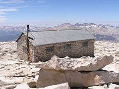
In 1891, the United States Geological Survey's Board on Geographic Names decided to recognize the earlier name Mount Whitney. Despite losing out on their preferred name, residents of Lone Pine financed the first trail to the summit, engineered by Gustave Marsh, and completed on July 22, 1904. Just four days later, the new trail enabled the first recorded death on Whitney. Having hiked the trail, U.S. Bureau of Fisheries employee Byrd Surby was struck and killed by lightning while eating lunch on the exposed summit. In response to this event, Marsh began work on the stone hut that would become the Smithsonian Institution Shelter, and completed it in 1909.[26]
A movement after World War II began to rename the mountain for Winston Churchill.[27] However, the name Mount Whitney has persisted.
Climbing routes
Trails
The most popular route to the summit is by way of the Mount Whitney Trail which starts at Whitney Portal, at an elevation of 8,360 ft (2,550 m), 13 mi (21 km) west of the town of Lone Pine. The hike is about 22 mi (35 km) round trip with an elevation gain of over 6,100 ft (1,900 m). Permits are required year round, and to prevent overuse a limited number of permits are issued by the Forest Service between May 1 and November 1.[28] The Forest Service holds an annual lottery for hiking and backpacking permits on the Mount Whitney Trail. Applications are accepted from February 1 through March 15. Any permits left over after the lottery is completed typically go on sale April 1.[29] Most hikers do the trip in two days which is still considered a strenuous endeavor. Those in good physical condition sometimes attempt to reach the summit and return to Whitney Portal in one day, thus requiring only a somewhat easier-to-obtain "day use" permit rather than the overnight permit, and allowing one not to carry overnight camping gear (sleeping bag and tent) up the mountain. This is considered an "extreme" day hike, which normally involves leaving Whitney Portal before sunrise and 12 to 18 hours of strenuous hiking,[30] while struggling with altitude sickness, cold air, and occasionally treacherous surface conditions (because snow and/or ice are normally present on parts of the trail, except for a short period from early July to late September).

Longer approaches to Whitney arrive at its west side, connecting to the Mount Whitney Trail near the summit by way of the John Muir Trail.
Scrambles
The "Mountaineer's Route", a gully on the north side of the east face first climbed by John Muir, is considered a scramble, class 3 (PD+).[31] The fastest recorded time up this route to the summit and back to the portal is 3 hours 10 minutes, by Jason Lakey of Bishop.[32]
Technical climbs

The steep eastern side of the mountain offers a variety of climbing challenges. The East Face route, first climbed in 1931, is one of the Fifty Classic Climbs of North America routes and involves technical free climbing (class 5.7) but is mostly class 4. Other routes range up to grade 5.10d.[31]
South of the main summit there are a series of minor summits that are completely inconspicuous from the west but appear as a series of "needles" from the east. The routes on these include some of the finest big-wall climbing in the high Sierra. Two of the needles were named after participants in an 1880 scientific expedition to the mountain. Keeler Needle was named for James Keeler and Day Needle was named for William Cathcart Day. The latter has now been renamed Crooks Peak after Hulda Crooks who hiked up Mount Whitney every year until well into her nineties.
See also
- List of mountain peaks of California
- List of highest points in California by county
- List of U.S. states by elevation
- List of the highest major summits of the United States
- List of the most prominent summits of the United States
- List of the most isolated major summits of the United States
References
- 1 2 3 4 "Whitney". NGS data sheet. U.S. National Geodetic Survey. Retrieved 2014-01-22.
- 1 2 "Mount Whitney, California". Peakbagger.com. Retrieved 2015-12-30.
- ↑ "Playas Valley/Pride Draw Saddle". Peakbagger.com. Retrieved 2015-12-30.
- ↑ "California 14,000-foot Peaks". Peakbagger.com. Retrieved 2016-03-24.
- ↑ "Sierra Peaks Section List" (PDF). Angeles Chapter, Sierra Club.
- ↑ "Western States Climbers List". Climber.org. Retrieved 2016-03-24.
- 1 2 3 Farquhar, Francis P. (1926). Place Names of the High Sierra. San Francisco: Sierra Club. Retrieved 2007-08-12.
- ↑ "Find Distance and Azimuths Between 2 Sets of Coordinates". Federal Communications Commission. Retrieved 2010-08-13.
- ↑ NPS (ed.). "John Muir and Pacific Crest Trails". Retrieved 2015-05-07.
- 1 2 3 about sports (ed.). "Mount Whitney: Highest Mountain in California". Retrieved 2015-05-08.
- ↑ Everytrail.com (ed.). "Trail Map of The High Sierra Trail: Segment 7 of 7 California". Retrieved 2015-05-08.
- ↑ Perlman, Eric (May 1985). "Nice Going, Whitney". Backpager: 49–55. Retrieved 8 May 2016.
- ↑ Joyce, Quinn (ed) (2015). Earth's Landscape: An Encyclopedia of the World's Geographic Features [2 volumes]. ABC-CLIO. pp. 511–512. ISBN 1610694465. Retrieved 8 May 2016.
- 1 2 3 Schoenherr, Allan A. (1995). A Natural History of California. University of California Press. ISBN 0-520-06922-6.
- ↑ "Height Conversion Methodology". U.S. National Geodetic Survey. Retrieved 2008-04-09.
- ↑ "Sierra Nevada". Ecological Subregions of California. US Forest Service. Archived from the original on 2008-06-01. Retrieved 2008-04-09.
- ↑ "The Great Basin". Great Basin National Park. US National Park Service. Retrieved 2008-04-09.
- 1 2 McPhee, John (2000). Annals of a Former World. Macmillian. ISBN 0374708460. Retrieved 2016-05-08.
- ↑ Whitney, Stephen (1979). A Sierra Club naturalist's guide to the Sierra Nevada. Sierra Club Books. p. 41. ISBN 0871562154. Retrieved 9 May 2016.
- ↑ King, Clarence (1902) [1872]. "Chapter XIII Mount Whitney". Mountaineering in the Sierra Nevada (10th ed.). ISBN 0-585-27432-0. Retrieved 2009-02-01.
- ↑
 Rines, George Edwin, ed. (1920). "Whitney, Mount". Encyclopedia Americana.
 - ↑ "Historic People And Places: WILLIAM B. WALLACE". Sequoia Parks Foundation. Retrieved 2015-10-04.
- ↑ Wallace, William B. (1902). "A Night On Mt. Whitney". Mt. Whitney Club Journal. 1. Visalia, CA: Mt. Whitney Club. pp. 8–9.
- ↑ Porcella, Stephen; Burns, Cameron (1998). Climbing California's Fourteeners: The Route Guide to the Fifteen Highest Peaks. Mountaineers Books. p. 55. ISBN 0-89886-555-7.
- ↑ Barbato, Lauren (2015-08-31). "5 Whitewashed American Landmarks That, Like Mount McKinley, Sorely Need A Name Change". www.bustle.com.
- ↑ "Mt. Whitney's Early Days". Mount Whitney History. Lone Pine Chamber of Commerce. Archived from the original on 2012-05-14. Retrieved 2009-02-01.
- ↑ "Mount Whitney". Geographic Names Information System. United States Geological Survey. Retrieved 2009-02-01.
- ↑ "Recreational Activities - Mt. Whitney". US Forest Service. Archived from the original on 2008-04-14. Retrieved 2008-04-09.
- ↑ "Mount Whitney Lottery - Permit Reservations". US Forest Service. Retrieved 2014-01-23.
- ↑ "Mt. Whitney – One Day Hike". dayhiker.com. Retrieved 2015-11-28.
- 1 2 Secor, R.J. The High Sierra Peaks, Passes, and Trails. Seattle: The Mountaineers.
- ↑ "Bishop Local Adds 5.13b Crack, And Speed Solos Whitney Region". Rock and Ice. December 9, 2010. Archived from the original on 2010-12-12.
Further reading
- Thompson, Doug; Elisabeth Newbold (1997). Mount Whitney: Mountain Lore from the Whitney Store. Westwind Publishing Company. ISBN 978-0-9653596-0-3.
External links
| Wikimedia Commons has media related to Mount Whitney. |
| Wikivoyage has a travel guide for Mount Whitney. |
- "Mt. Whitney Trail". Inyo National Forest.
- "Mt Whitney Hikers Association".
- "Whitney Portal Store".
- "Mount Whitney". SummitPost.org.
-
 Gilman, D. C.; Thurston, H. T.; Colby, F. M., eds. (1905). "Whitney, Mount". New International Encyclopedia (1st ed.). New York: Dodd, Mead.

Sacramento (capital) | ||
| Topics |  | |
| Regions |
| |
| Metro regions | ||
| Counties |
| |
| Most populous cities | ||