Maroon Bells
| Maroon Bells | |
|---|---|
 Maroon Bells | |
| Highest point | |
| Peak | Maroon Peak |
| Elevation | 14,163 ft (4,317 m) [1][2] NAVD88 |
| Prominence | 2336 ft (712 m) [3] |
| Isolation | 8.06 mi (12.97 km) [3] |
| Listing | |
| Coordinates | 39°04′15″N 106°59′20″W / 39.0708492°N 106.9889921°WCoordinates: 39°04′15″N 106°59′20″W / 39.0708492°N 106.9889921°W [1] |
| Geography | |
 Maroon Bells | |
| Location | Gunnison and Pitkin counties, Colorado, United States[1] |
| Parent range | Elk Mountains[4] |
| Topo map |
USGS 7.5' topographic map Maroon Bells, Colorado[1] |
| Climbing | |
| First ascent | 1890s by C. Wilson |
| Easiest route | Exposed scramble, class 4 |
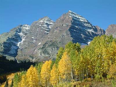
The Maroon Bells are two peaks in the Elk Mountains, Maroon Peak and North Maroon Peak, separated by about a third of a mile. The mountains are on the border between Pitkin County and Gunnison County, Colorado, United States, about 12 miles southwest of Aspen. Both peaks are fourteeners. Maroon Peak, at 14,163 feet (4317.0 m), is the 27th highest peak in Colorado. North Maroon Peak, at 14,019 feet (4273.0 m), is the 50th highest. The view of the Maroon Bells to the southwest from the Maroon Creek valley is commonly photographed. The peaks are located in the Maroon Bells-Snowmass Wilderness of White River National Forest.[5][6]
Geology of the Maroon Bells
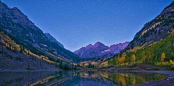
A US Forest Service sign on the access trail refers to these mountains as "The Deadly Bells" and warns would-be climbers of "downsloping, loose, rotten and unstable" rock that "kills without warning". Unlike other mountains in the Rockies that are composed of granite and limestone, the Bells are composed of metamorphic sedimentary mudstone that has hardened into rock over millions of years. Mudstone is weak and fractures readily, giving rise to dangerously loose rock along almost any route. The mudstone is responsible for the Bells' distinctive maroon color. The Bells got their "deadly" name in 1965 when eight people died in five separate accidents. Maroon Lake (9,580') occupies a basin that was sculpted by Ice-Age glaciers and later dammed by landslide and rockfall debris from the steep slopes above the valley floor.
Recreation
The Maroon Bells are an increasingly popular destination for day and overnight visitors; over 300,000 people visit the Bells every season. Due to the volume of people, a bus service runs everyday from 8am-5pm from mid-June, through the first weekend in October. During these times, vehicle access is limited only to those with handicap placards, or disability license plates. The bus runs from Aspen Highlands to Maroon Lake every 20 minutes. The Maroon Bells scenic area features several hiking trails ranging from short hikes near Maroon Lake to longer hikes into the Maroon-Snowmass Wilderness.[7]
Protection and Preservation
Because the Maroon Bells area receives such high levels of visitor use, the USFS has established a long-term plan to protect and preserve the scenic area and larger wilderness areas. Solutions include the required use of bear canisters for backcountry campers, management of day and overnight use, leashed dog education and ticketing, reduction of heavy horse use in high use areas, and prohibiting overnight camping and excessive day use at particular sites. [8]
See also
References
- 1 2 3 4 "MAROON PEAK". NGS data sheet. U.S. National Geodetic Survey. Retrieved January 6, 2016.
- ↑ The elevation of Maroon Peak includes an adjustment of +2.048 m (+6.72 ft) from NGVD 29 to NAVD 88.
- 1 2 "Maroon Peak, Colorado". Peakbagger.com. Retrieved January 6, 2016.
- ↑ "Maroon Peak". Geographic Names Information System. United States Geological Survey. Retrieved October 29, 2014.
- ↑ "Maroon Bells-Snowmass Wilderness". Wilderness.net. Retrieved August 11, 2012.
- ↑ "Maroon Bells-Snowmass Wilderness Area". Colorado Wilderness. Retrieved August 11, 2012.
- ↑ "Hiking Guide to Maroon Bells Colorado". Dayhikes Near Denver. Retrieved 19 March 2016.
- ↑ "Wilderness Education Plan Maroon Bells-Snowmass Wilderness Aspen – Sopris and Gunnison Ranger District". United States Forest Service. USFS. Retrieved 19 March 2016.
External links
- Guide to Maroon Bells Colorado
- Maroon Bells on 14ers.com
- Maroon Bells on Distantpeak.com
- Maroon Bells Scenic Area on USFS
