Black Elk Peak
| Black Elk Peak | |
|---|---|
 Black Elk Peak from Palmer Gulch (August 2006) | |
| Highest point | |
| Elevation | 7,244 ft (2,208 m) NAVD 88[1] |
| Prominence | 2,922 ft (891 m) [2] |
| Listing | |
| Coordinates | 43°51′57″N 103°31′57″W / 43.865847725°N 103.532431997°WCoordinates: 43°51′57″N 103°31′57″W / 43.865847725°N 103.532431997°W [1] |
| Geography | |
 Black Elk Peak | |
| Parent range | Black Hills |
| Topo map | USGS Custer |
| Climbing | |
| First ascent | July 24, 1875 by Valentine McGillycuddy and party[3] |
| Easiest route | hike, Trail 9[4] |
 |
| Black Hills and Badlands |
|---|
 |
| Sculpture |
| Geologic formations |
| Mountains |
|
| Caves |
| Parks, forests, and grassland |
| Lakes |
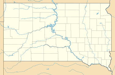
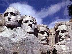
Black Elk Peak (formerly Harney Peak) is the highest natural point in South Dakota. It lies in the Black Elk Wilderness area, in southern Pennington County, in the Black Hills National Forest.[2] The peak lies 3.7 mi (6.0 km) WSW of Mount Rushmore.[5] At 7,242 feet (2,207 m),[1] it has been described by the Board on Geographical Names as the highest summit in the United States east of the Rocky Mountains. It is also known as Hinhan Kaga (in Lakota) and the federal government has deemed it "Black Elk Peak."
Guadalupe Peak and Sierra Blanca also lie far to the east of the Continental Divide and are substantially higher, but they are located south of the Rockies.
The U.S. Board on Geographic Names, which has jurisdiction in federal lands, officially changed the mountain's name from "Harney Peak" to "Black Elk Peak" on August 11, 2016, honoring Black Elk, the noted Lakota Sioux medicine man for whom the Wilderness Area is named.[6]
Hinhan Kaga
This peak was called Hinhan Kaga ("Making of Owls", after rock formations that look like owls[7] and the association of owls with impending death) by the Lakota Sioux).[8] They dominated this region and occupied the territory at the time of European colonization. They considered it a sacred site within the Black Hills, which they call Pahá Sápa, also written He Sapa.[8]
The mountain was named Harney Peak in 1855 by American Lieutenant Gouverneur K. Warren in honor of US General William S. Harney, his commander in a regional military expedition. In punitive retaliation for other Sioux raids, in September 1855 Harney's forces killed Brulé Sioux warriors, women and children in what Americans called the Battle of Blue Water Creek in Garden County, Nebraska.[6]
Harney later commanded the United States military in the Black Hills area in the late 1870s.[9] The Lakota have tried to get the name of the peak changed for 50 years,[10] as Harney had massacred their people.[11]
In 2014 the Sioux renewed their effort to get the name changed, in an effort led by Basil Brave Heart of the Pine Ridge Indian Reservation. A Korean War veteran, he felt that Harney had not honored the military with his action.[6][11]
Some Lakota requested state officials in 2015 to reinstate their original name Hinhan Kaga for the peak. The Lakota Council of the Pine Ridge Reservation and descendants of Black Elk, a noted medicine man, supported naming it for him, as the national wilderness area around the peak is named for the shaman.[10]
He became known beyond the Lakota in part through the book Black Elk Speaks (1932), written by John G. Neihardt from long talks with the shaman.[12][13] South Dakota Governor Dennis Daugaard opposed the name change, as did other state officials, and no action was taken in 2015.
The U.S. Board on Geographic Names officially changed the mountain's name from "Harney Peak" to "Black Elk Peak" on August 11, 2016, by a unanimous vote of 12–0, with one abstention.[6][9] On August 18, 2016, Gov. Daugaard announced that the state would accept the new name.[14]
History
Hinhan Kaga and the Black Hills were protected within the Great Sioux Reservation established by the United States government in the Treaty of Fort Laramie in 1868; it covered most of the territory west of the Missouri River in South Dakota (the area now called West River). American settlement was concentrated east of the river, where there was more water for farming.
The first Americans believed to have reached the summit were a party led by General George Armstrong Custer in 1874, during the Black Hills expedition. He was looking for gold.[15] The federal government took back the Black Hills and another strip of land in a new treaty in 1877. More than a decade later, it broke up the Great Sioux Reservation in 1889 into five smaller reservations, the same year that North Dakota and South Dakota were admitted as states to the Union. The government made some 9 million acres of former Lakota land available for purchase for ranching and homesteading. Most American settlement in West River did not start until the early 20th century. The area attracted many European immigrants as well as migrants from the East.
Harney Peak is the site where Black Elk (Lakota Sioux) received his "Great Vision" when nine years old. He later became a medicine man known for his wisdom. Late in life, he returned to the peak accompanied by writer John Neihardt. Black Elk was sharing much of his life and philosophy with Neihardt through long talks translated by his son. Neihardt tried to express the medicine man's wisdom in his book Black Elk Speaks (1932).[note 1]
Neihardt recorded Black Elk's words about his vision as follows:
"I was standing on the highest mountain of them all, and round about beneath me was the whole hoop of the world," he is quoted as saying. "And while I stood there I saw more than I can tell and I understood more than I saw; for I was seeing in a sacred manner the shapes of all things in the spirit, and the shape of all shapes as they must live together like one being."[16]
American settlers used Harney Peak as a fire lookout tower in 1911, with a wood crate placed at the summit for a seat. In 1920, a 12'x12' wood structure was built, and it was expanded to 16'x16' the following year. The federal Civilian Conservation Corps enlisted local men and completed construction of a stone fire tower in 1938, one of numerous projects in the state during the Great Depression. The Harney Peak fire tower was last staffed in 1967.[17]
A United States post office was operated at Harney Peak from 1936 until 1942, and again from 1945 until 1946.[18] The Harney Creek post office was reportedly one of the "most elevated post offices in the United States".[19]
In May 2015 the South Dakota Board of Geographic Names recommended renaming Harney Peak as Hinhan Kaga, to remove the name of a commander known for massacring Sioux women and children at the Battle of Blue Water Creek [20] and to honor the original Lakota name for the mountain.[7] At the end of the following month, the board reversed the recommendation that the peak be renamed saying that "there was no public consensus on a new name."[20] The Lakota were divided on a preferred name, and Republican Governor Dennis Daugaard and some other Americans opposed any name change.[6]
The recommendation for renaming went to the federal US Board on Geographic Names.[21] The federal board acknowledged that the name was of concern to the Lakota, and its spokesman said, "In this case, the board felt that the name was derogatory or offensive, being that it was on a holy site of the Native Americans."[6] In a decision published August 11, 2016, the United States Board on Geographic Names adopted the name "Black Elk Peak."[22]
Hiking
The summit can be reached from Sylvan Lake, Camp Remington, Highway 244, Palmer Creek Rd., Mount Rushmore, or Horse Thief Lake. From the trailhead at Sylvan Lake in Custer State Park, to the summit and back is about 7 miles (11 km).[4] This is the shortest, least strenuous, and most popular route. No permit is required for use of the first portion of the trail. However, the United States Forest Service requires hikers to obtain a permit at a self-service kiosk located at the entrance to the Black Elk Wilderness area en route to the summit.[23]
An old stone tower, once used as a fire lookout tower, is located at the summit. The ashes of Valentine McGillycuddy were interred near the base of the tower and a plaque reads, "Valentine McGillycuddy, Wasicu Wacan." Wasicu Wacan is Lakota for "Holy White Man."[24] Note that "wacan" is commonly spelled "wakan" in most Lakota societies.
Gallery
-
%2C_1842-1893.png)
Granite Knob and Harney's Peak, by William H. Illingworth, 1874
-

View from the top of the Black Elk Peak lookout tower.
-

Fire lookout tower at the summit.
-

A Mountain goat near the top of Black Elk Peak.
-

A man-made dam is located near the summit.
See also
Notes
- ↑ See chapter 3 and the Author's Postscript of Black Elk Speaks, Bison Books, 2004.
References
- 1 2 3 "Harney". NGS data sheet. U.S. National Geodetic Survey. Retrieved 2008-11-08.
- 1 2 "Harney Peak, South Dakota". Peakbagger.com. Retrieved 2008-12-29.
- ↑ James R. Macdonald, Ph.D (2009). "Museum of Geology: History". Rapid City, South Dakota: South Dakota School of Mines & Technology. Retrieved 2012-11-10.
- 1 2 "Harney Area Trailheads". South Dakota Fish, Game and Parks. Retrieved 2012-11-10.
- ↑ Mount Rushmore, South Dakota, 30x60 Minute Topographic Quadrangle, USGS, 1977
- 1 2 3 4 5 6 David Rooks, "Breaking: Black Elk Peak Soars Above The He Sapa, No Longer Harney Peak", Indian Country Today, 12 August 2016; accessed 12 August 2016
- 1 2 Carrie Moore (2015). "Hill City Prevailer-News". Hill City Prevailer-News. Retrieved 2015-06-04.
- 1 2 Steve Russell, "Names Have Power: Denali and Other Colonist Lies", Indian Country Today, 4 September 2015; accessed 4 November 2016
- 1 2 "Black Elk Peak". Geographic Names Information System. United States Geological Survey. Retrieved 11 August 2016.
- 1 2 Stu Whitney, "Whitney: In defense of Black Elk Peak", Argus Leader, 12 August 2016; accessed 15 August 2016
- 1 2 David Rooks, "Black Elk Peak ‘Answer to Many Prayers’: Basil Brave Heart", Indian Country Today, 15 August 2016; accessed 15 August 2016
- ↑ Nord, James (May 1, 2015). "Activists work for Native American-friendly site names". The Elkhart Truth. Associated Press.
- ↑ Louwagie, Lacey (July 6, 2015). "Despite Objections, 'Harney Peak' Name Stays". Courthouse News Service.
- ↑ Tupper, Seth (19 August 2016). "Gov: State won't fight Harney rename". Rapid City Journal. pp. A1.
- ↑ Connell, Evan S. (1984). Son Of The Morning Star. San Francisco, California: North Point Press. pp. 237–238. ISBN 0-86547-160-6.
- ↑ "Harney Peak". SouthDakota.com. Retrieved 2012-11-10.
- ↑ Saum, Bradley D. (2013). Harney Peak Revealed. Createspace. pp. 34–36. ISBN 9781478316756.
- ↑ U.S. Geological Survey Geographic Names Information System: Harney Peak Post Office (historical)
- ↑ Federal Writers' Project (1940). South Dakota place-names, v.1–3. University of South Dakota. p. 40.
- 1 2 South Dakota Board of Geographic Names (2015). "Harney Peak Written Public Comments" (PDF). South Dakota Board of Geographic Names. Retrieved 2015-06-04.
- ↑ "In Reversal, SD Board Would Keep Harney Peak Name". Pierre, SD: Associated Press. 29 June 2015. Retrieved 14 July 2015.
- ↑ Nord, James (11 August 2016). "Feds Rename South Dakota's Highest Peak to Black Elk Peak". ABC News. Retrieved 11 August 2016.
- ↑ "Harney Peak". SummitPost.org. Retrieved 2012-11-12.
- ↑ "McGillycuddy House at the heart of city history". Retrieved 2012-11-12.
External links
- Regenold, Stephen (2008-04-02). "High in the Black Hills, as Seasons Turn". The New York Times.
- "Facts About Harney Peak". Climbing.About.com.