Three Sisters (Oregon)
| Three Sisters | |
|---|---|
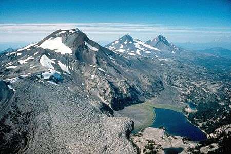 The Three Sisters, looking north | |
| Highest point | |
| Elevation | |
| Prominence | |
| Listing | US most prominent peaks 85th |
| Coordinates | 44°06′12″N 121°46′09″W / 44.103449°N 121.7692058°WCoordinates: 44°06′12″N 121°46′09″W / 44.103449°N 121.7692058°W [4] |
| Geography | |
 Three Sisters Location in Oregon | |
| Location | Lane and Deschutes counties, Oregon, U.S. |
| Parent range | Cascade Range |
| Topo map | USGS South Sister and North Sister |
| Geology | |
| Age of rock | Quaternary |
| Mountain type | Complex volcano, made up of stratovolcanoes and a shield volcano |
| Volcanic arc | Cascade Volcanic Arc |
| Last eruption | 50 BCE (?)[5] |
| Climbing | |
| Easiest route | Hiking or scrambling, plus glacier travel on some routes[6] |
The Three Sisters are a complex volcano of three volcanic peaks of the Cascade Volcanic Arc and the Cascade Range in the U.S. state of Oregon. Each exceeding 10,000 feet (3,000 m) in elevation, they are the third-, fourth-, and fifth-highest peaks in the state of Oregon, and are located in the Three Sisters Wilderness, about 10 miles (16 km) south of the nearest town of Sisters. Diverse species of flora and fauna inhabit the area on and around the mountains, which is subject to frequent snowfall, occasional rain, and extreme temperature differences between seasons. The mountains, particularly South Sister, are popular for climbing and scrambling.
Although they are often grouped together and seen as one unit, the three mountains evolved under differing geologic situations, and the petrologic composition of each mountain can vary significantly. Whereas North Sister is extinct and Middle Sister is dormant, South Sister last erupted about 2,000 years ago and still could erupt, threatening life within the region. After satellite imagery detected tectonic uplifting near South Sister in 2000, the United States Geological Survey made plans to improve monitoring in the immediate area.
Geography and geology

The Three Sisters are located on the boundaries of Lane and Deschutes counties and the Willamette and Deschutes national forests in the U.S. state of Oregon, about 10 miles (16 km) south of the nearest town of Sisters.[7] The three peaks, the third-, fourth-, and fifth-highest peaks in Oregon,[8] have 15 named glaciers among them, nearly half of the 35 named glaciers in Oregon. The Sisters were named Faith, Hope, and Charity by early settlers, but "these names have not prevailed", and instead they are named North Sister, Middle Sister, and South Sister.[9][10]
A complex volcano that extends for 20 miles (32 km),[9] the Three Sisters are located at latitude 44.103° N and longitude 121.768° W.[11] Part of the Cascade Volcanic Arc and the Cascade Range,[12] the volcanoes formed during separate time periods from several varieties of magma, and the amount of rhyolite found in the lava of the younger two mountains is unusual relative to nearby volcanoes.[9] Like other Cascade volcanoes, the Three Sisters were fed by magma chambers produced by the subduction of the Juan de Fuca Plate under the western edge of the North American Plate.[12] They were also affected by the changing atmosphere of the Pleistocene epoch, a geologic period during which an Ice Age occurred where glaciers ate away at mountains as they retreated.[13] Specifically, Three Sisters join several other volcanoes in the eastern segment of the Cascade Range known as the High Cascades, which trends from north–south.[12]
The Three Sisters form the centerpiece of a region of closely grouped volcanic peaks, an exception to the typical 40-to-60-mile (64 to 97 km) spacing between volcanoes elsewhere in the Cascades. These nearby peaks include Belknap Crater, Mount Washington, Black Butte, and Three Fingered Jack to the north, and Broken Top and Mount Bachelor to the south.[14] The region was active in the Pleistocene epoch, with eruptions between 700,000 and 170,000 years ago from an explosively active complex known as the Tumalo volcanic center. Basaltic lava flows from North Sister overlay the newest Tumalo pyroclastic deposits, placing the age of North Sister, the eldest, at less than 170,000 years.[15][16]
Wilderness and climate
The Three Sisters Wilderness covers an area of 281,190 acres (1,137.9 km2), making it the second-largest wilderness area in Oregon. Created by the U.S. Congress in 1964, it borders the Mount Washington Wilderness to the north and shares a southern edge with the Waldo Lake Wilderness. The Three Sisters Wilderness includes 260 miles (420 km) of trails, in addition to many forests, lakes, waterfalls, and streams, such as the source of Whychus Creek.[17] More specifically, the Three Sisters and Broken Top account for about a third of the Three Sisters Wilderness—an area known as the Alpine Crest Region. Rising from about 5,200 feet (1,600 m) to 10,358 feet (3,157 m) in elevation, it features the wilderness area's most-frequented glaciers, lakes, and meadows.[18]
Weather in the area varies because of separation created by the mountain barrier. The west is wetter and the east is drier, and precipitation increases with elevation. The moisture, falling mostly as winter snow, originates from warm air pockets over the Pacific Ocean and cools as it ascends the mountains. In the western section, precipitation ranges from 80 to 125 inches (200 to 320 cm) annually, varying from 40 to 80 inches (100 to 200 cm) in the east. Temperature extremes reach 80 to 90 °F (27 to 32 °C) in summers and −20 to −30 °F (−29 to −34 °C) during the winters.[19]
In the wilderness, part of the National Wilderness Preservation System, motor vehicles and means of transport are prohibited. These include bicycles, wagons, motorboats, and helicopters. From Memorial Day to October 31, permits are required for entry to the wilderness.[20]
Flora and fauna
While Douglas fir and ponderosa pine trees predominate in the western and eastern parts of the Cascades, respectively,[21][22] flora in the Three Sisters Wilderness also consists of lodgepole pine, Pacific silver fir, subalpine fir, western hemlock,[8] western white pine, Englemann spruce, and western redcedar. White fir, once a common species in the area, has declined due to recent blights of mountain pine beetle.[23] At higher altitudes, alpine meadows are common,[8] and they feature the following flowers: lupine, red Indian paintbrush, heather, arnica, larkspur, sunflowers, columbines, and many other genera. Also common at high altitudes are mountain hemlock and whitebark pine trees.[8][23]
The local fauna of the Three Sisters includes fish such as brook and rainbow trout,[8] birds such as blue and ruffed grouse, and larger species like the Columbian black-tailed deer, mule deer, Roosevelt elk, and American black bear. In addition to predator bobcats, cougars, and coyotes, raccoons, martens, weasels, and American minks live throughout the Three Sisters area.[23]
Peaks
North Sister

North Sister, also known as "Faith," is the oldest and most eroded of the three, with towering rock pinnacles and glaciers. A stratovolcano atop an ancient shield volcano named Little Brother,[24][25] North Sister is 5 miles (8.0 km) wide.[25] Consisting primarily of basaltic andesite, it is more mafic (rich in magnesium and iron) than the other two volcanoes.[26] Its deposits are rich in palagonite and red and black cinders, and grow progressively more iron-rich with decreasing age.[25] North Sister's lava flows demonstrate similar composition throughout its eruptive history, which lasted for a long period of time.[26] Estimates place the volcano's last eruption at more than 100,000 years ago, so the volcano is considered extinct.[27] The North Sister possesses more dikes than any similar Cascade peak, and many dikes were pushed aside by the intrusion of a 980-foot (300 m)-wide plug dome that now forms the mountain's summits of Prouty Peak and the South Horn. The remainder of the peak is chiefly loose debris held in place by the dike system.[28]
North Sister has not erupted since the late Pleistocene.[16] Extensive erosion exposed the volcanic edifice, including magma pathways such as dikes and sills.[26] At one point, the volcano stood more than 11,000 feet (3,400 m) in elevation, but this erosion claimed a quarter to a third of its original volume.[29]
Middle Sister

Middle Sister also known as "Hope," is a stratovolcano consisting primarily of basalt, but it also has erupted andesite, dacite, and rhyodacite.[30] The smallest and most poorly-studied of the trio, it is the middle in age,[16] the most recent flows dating to 14,000 years ago, slightly older than South Sister's.[28] Thick and rich in dacite, the flows extended from the northern and southern sides. They stand in contrast to older, andesitic lava remains that reach as far as 4.35 miles (7.00 km) from the volcano's base.[31]
The mountain has a cone shape with the eastern side lost to glaciation but the western portion nearly intact.[29] The Hayden and Diller glaciers continue to cut into the east face, while the Renfrew Glacier sits on the northwestern slope. The large but retreating Collier Glacier descends along the north side of Middle Sister, cutting into North Sister's west side.[32] Erosion from Pleistocene and Holocene glaciation exposed a plug near the center of Middle Sister.[31]
South Sister

South Sister, also known as "Charity," is the youngest and tallest volcano of the trio. The eruptive products range from basaltic andesite to rhyolite and rhyodacite.[16][33] It is a stratovolcano overlying an older shield structure, no more than 50,000 years old,[34] and last erupted about 2,000 years ago.[5] The first such episode, termed the Rock Mesa eruptive cycle, first spread tephra from flank vents from the south and southwest flanks, followed by a thick rhyolite lava flow. The second cycle, the Devils Hill eruptive cycle, was similar in result, but was caused by the intrusion of a dike of new silicic magma that erupted from about 20 vents on the southeast side and from a smaller line on the north side.[35]
Unlike its sister peaks,[36] South Sister has an uneroded summit crater about 1⁄4 mile (0.40 km) in diameter that holds a small crater lake known as Teardrop Pool, the highest lake in Oregon.[37] The slopes of South Sister have a number of small glaciers, including the Lewis, Clark, Lost Creek and Prouty glaciers near the crater rim.[38]
Climbing and recreation
The Three Sisters are a popular climbing destination for hikers and mountaineers. The United States Forest Service requires permits for use from Memorial Day until the beginning of September, and dogs must be kept on leashes on the Green Lakes, Moraine Lakes, South Sister, Soda Creek, Todd Lake, and Crater Ditch trails from July 15 through September 15. Horses are prohibited, and ice axes are required during the winter climbing season for safety reasons.[39]
Due to extensive erosion, which causes rockfall, North Sister is the most dangerous climb of the three volcanic peaks.[40] However, one of its peaks, Little Brother, can be scrambled.[41] The first recorded ascent of North Sister was made by six people, including Oregon politicians George Lemuel Woods and James McBride, in 1857, according to a story published in Overland Monthly in 1870.[42][43] Today, the common trail lasts 11 miles (18 km) round-trip, gaining 3,165 feet (965 m) in elevation and lasting about 6–7 hours for the average climber. After passing through forest, lava flows, and meadows, from the summit scramblers can see various cinder cones as well as North Sister and nearby volcanoes.[41]
Middle Sister can also be scrambled, for a round-trip of 16.4 miles (26.4 km) and an elevation gain of 4,757 feet (1,450 m). The trip lasts about 12 hours, beginning with a route through dense forest and ending on Middle Sister's southern summit. In addition to views of North Sister, the summit offers sights of South Sister, Hayden Glacier, and other Cascade Volcanoes including Mount Hood.[44]
The standard climbing route up the south ridge of South Sister runs for 12.6 miles (20.3 km) round-trip, and rises from 5,446 feet (1,660 m) at the trailhead to 10,358 feet (3,157 m) at its summit. Traveling over cinder cones, domes, and lava flows, the hike does not become demanding until the last mile as it ascends to the summit.[45] In his book Into the Wild, Jon Krakauer notes that his first climb of South Sister with his father inspired him to pursue mountaineering. Popular starting points are the Green Lakes and Devils Lake trailheads.[46] Although this path does not require any technical skills or much in the way of mountaineering knowledge, many environmental dangers remain the same, and rescue operations are common during the climbing season.[47]
Recent history and potential hazards
Neither North nor Middle Sister is likely to resume volcanic activity,[36] while South Sister could become active. If South Sister were to erupt, it would pose a threat to nearby life. The proximal danger zone extends from 1.24 to 6 miles (2.00 to 9.66 km) from the volcano's summits.[48] Tephra would accumulate to 1 to 2 inches (25 to 51 mm) in the city of Bend, and lahars (volcanically induced mudflows) and pyroclastic flows would run down the flanks of the mountain, threatening any life in their paths.[16]
South Sister was found to be potentially active when in 2000, satellite imagery showed a deforming tectonic uplift 3 miles (4.8 km) west of the mountain. The ground began to bulge in late 1997, when magma started to pool about 4 miles (6.4 km) underground.[49] Scientists were concerned that the volcano was awakening. A map at the Lava Lands Visitor Center of the Newberry National Volcanic Monument south of Bend shows the extent of the uplift, which reaches a maximum of 11 inches (28 cm). In 2004 an earthquake swarm occurred with an epicenter in the area of uplift, and the hundreds of small earthquakes subsided after several days. By 2007 the uplift had slowed somewhat, though the area was still considered potentially active.[50] In February 2013, scientists determined that the uplift had slowed to a rate of about 0.3 inches (7.6 mm) per year, compared to up to 2 inches (51 mm) per year in the early 2000s.[49] Because of the uplift at South Sister, the United States Geological Survey planned to increase monitoring of the Three Sisters and their vicinity by installing a global positioning system (GPS) receiver, sampling airborne and ground-based gases, and adding seismometers.[51]
See also
| Wikimedia Commons has media related to Three Sisters (Oregon). |
Notes
- 1 2 "South Sister, Oregon". Peakbagger.com. Retrieved 2008-04-02.
- 1 2 "Middle Sister, Oregon". Peakbagger.com. Retrieved 2008-04-02.
- 1 2 "North Sister, Oregon". Peakbagger.com. Retrieved 2008-04-02.
- ↑ "South Sister". Geographic Names Information System. United States Geological Survey.
- 1 2 "South Sister". Global Volcanism Program. Smithsonian Institution. Retrieved 2008-04-02.
- ↑ Bishop 2004, pp. 139–142.
- ↑ Richard, Terry (2010-08-28). "Three Sisters loop offers one of Oregon's most scenic backpack trips". OregonLive.com. Advance Internet. Retrieved 2013-08-13.
- 1 2 3 4 5 "Three Sisters Wilderness". U.S. Forest Service. Retrieved 2013-08-13.
- 1 2 3 "Geology and History Summary for Three Sisters". U.S. Geological Survey, Cascades Volcano Observatory. Retrieved 2014-02-26.
- ↑ McArthur 1974, p. 544.
- ↑ "Three Sisters". U.S. Geological Survey, Cascades Volcano Observatory. Retrieved 2014-08-13.
- 1 2 3 Joslin 2005, p. 30.
- ↑ Joslin 2005, pp. 30–31.
- ↑ Harris 2005, p. 179.
- ↑ Harris 2005, pp. 182–183.
- 1 2 3 4 5 Sherrod, David R.; Edward M. Taylor; Mark L. Ferns; William E. Scott; Richard M. Conrey; Gary A. Smith (2004). "Geologic Map of the Bend 30-×60-Minute Quadrangle, Central Oregon" (PDF). Geologic Investigations Series I–2683. U.S. Geological Survey. p. 11. Retrieved 2014-10-03.
- ↑ "Three Sisters Wilderness: General". Wilderness.net. U.S. Forest Service and the University of Montana. Retrieved 2014-08-15.
- ↑ Joslin 2005, p. 34.
- ↑ Joslin 2005, pp. 32–33.
- ↑ "Three Sisters Wilderness: Area Management". Wilderness.net. U.S. Forest Service and the University of Montana. Retrieved 2014-08-15.
- ↑ "West Cascade Range Crest, Oregon and Washington: The Pacific Coast Old-Growth Forest". U.S. Forest Service. Retrieved 2014-08-19.
- ↑ "East of Cascade Range Crest, Oregon and Washington: Old Growth Ponderosa Pine Forests". U.S. Forest Service. Retrieved 2014-08-19.
- 1 2 3 "Three Sisters Wilderness". SummitPost. 2010-09-15. Retrieved 2014-08-14.
- ↑ "Dynamic Map Three Sisters". National Atlas of the United States. U.S. Department of the Interior. 2013-01-14. Retrieved 2014-08-14.
- 1 2 3 Wood 1992, p. 184.
- 1 2 3 "Eruption History for North Sister". U.S. Geological Survey. 2013-11-15. Retrieved 2014-08-14.
- ↑ "Oregon Volcanoes – North Sister Volcano". U.S. Forest Service. 2004-03-25. Archived from the original on 2011-05-12.
- 1 2 Harris 2005, pp. 182–184.
- 1 2 Joslin 2005, p. 35.
- ↑ "Oregon Volcanoes – Middle Sister Volcano". U.S. Forest Service. 2004-03-25. Archived from the original on 2011-05-16.
- 1 2 Wood 1992, p. 185.
- ↑ Harris 2005, pp. 186–187.
- ↑ "Oregon Volcanoes – South Sister Volcano". U.S. Forest Service. 2004-03-25. Archived from the original on 2011-05-12.
- ↑ Harris 2005, p. 189.
- ↑ Harris 2005, p. 190.
- 1 2 Joslin 2005, p. 37.
- ↑ Harris 2005, pp. 187–188.
- ↑ Harris 2005, p. 192.
- ↑ "South Sister Climber Trail". U.S. Forest Service. Retrieved 2014-08-15.
- ↑ Smoot 1993, p. 137.
- 1 2 Bond 2005, pp. 59–61.
- ↑ "Story of First Ascent of North Sister is Related". Eugene Register-Guard. 1942-01-04. p. 9. Retrieved 2015-04-26.
- ↑ Mrs. F. F. Victor (March 1870). "Trail-Making in the Oregon Mountains". Overland Monthly. 4 (3): 201–213. Retrieved 2015-04-26.
- ↑ Bond 2005, pp. 61–64.
- ↑ Bishop 2004, p. 139.
- ↑ Harris 2005, p. 199.
- ↑ Frick-Wright, Peter (2009-10-16). "South Sister climb deserves more respect". OregonLive.com. Advance Internet. Retrieved 2014-02-26.
- ↑ Scott 2001, p. 8.
- 1 2 "Bulge at Oregon's South Sister volcano barely growing". The Register-Guard. Eugene, Oregon. Associated Press. 2013-02-05. Retrieved 2013-05-26.
- ↑ "Three Sisters, Oregon Information Statement". U.S. Geological Survey. 2007-04-11. Retrieved 2008-04-02.
- ↑ "Three Sisters: Index of Monthly Reports". Global Volcanism Program. Smithsonian Institution. 2013. Retrieved 2014-08-15.
References
- Bishop, Ellen M.; John E. Allen (2004). Hiking Oregon's Geology. Seattle, Washington: Mountaineers Books. ISBN 978-0-89886-847-0.
- Bond, Barbara I. (2005). 75 Scrambles in Oregon: Best Non-Technical Ascents. Seattle, Washington: Mountaineers Books. ISBN 978-0-89886-550-9.
- Harris, Stephen L. (2005). "Chapter 13: The Three Sisters". Fire Mountains of the West: The Cascade and Mono Lake Volcanoes (Third ed.). Missoula, Montana: Mountain Press Publishing Company. ISBN 0-87842-511-X.
- Joslin, Les (2005). The Wilderness Concept and the Three Sisters Wilderness: Deschutes and Willamette National Forests, Oregon. Bend, Oregon: Wilderness Associates. ISBN 978-0-9647167-4-2.
- McArthur, Lewis A. (1974). Oregon Geographic Names (Fourth ed.). Portland, Oregon: Oregon Historical Society. ISBN 0-87595-102-3.
- Scott, W.E.; Iverson, R.M.; Schilling, S.P.; Fisher, B.J. (2001). "Volcano Hazards in the Three Sisters Region, Oregon". Open-File Report 99-437. U.S. Geological Survey. Retrieved 2008-05-01.
- Smoot, Jeff (1993). Climbing the Cascade Volcanoes. Guilford, Connecticut: Globe Pequot Press. ISBN 1-56044-889-X.
- "South Sister". NGS data sheet. U.S. National Geodetic Survey. Retrieved 2008-04-02.
- Wood, Charles A.; Kienle, Jurgen, eds. (1992). Volcanoes of North America: United States and Canada. Cambridge, England: Cambridge University Press. ISBN 978-0-521-43811-7.
| British Columbia |  | |
|---|---|---|
| Washington | ||
| Oregon | ||
| California | ||