Delano Peak
| Delano Peak | |
|---|---|
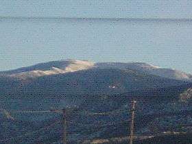 Delano Peak on January 1, 2006 | |
| Highest point | |
| Elevation | 12,174 ft (3,711 m) NAVD 88[1] |
| Prominence | 4,689 ft (1,429 m) [2] |
| Listing |
|
| Coordinates | 38°22′09″N 112°22′17″W / 38.369194964°N 112.371398381°WCoordinates: 38°22′09″N 112°22′17″W / 38.369194964°N 112.371398381°W [1] |
| Geography | |
| Location | Beaver / Piute counties, Utah, U.S. |
| Parent range | Tushar Mountains |
| Topo map | USGS Delano Peak |
Delano Peak is the highest point in the Tushar Mountains of south-central Utah. The Tushars are the third-highest range in the state, after the Uinta Mountains and the La Sal Range, though Delano itself is surpassed in height by at least thirty-one other Utah peaks.
Located in the Fishlake National Forest, Delano Peak is the highest point in both Beaver and Piute counties. The mountain is named for Columbus Delano (1809–1896), Secretary of the Interior during the Grant administration.[4]
Geography
Delano Peak is located just east of Beaver, Utah and can be seen clearly from I-70 and I-15.
References
- 1 2 "Delano Peak M 5". NGS data sheet. U.S. National Geodetic Survey. Retrieved 2016-04-12.
- ↑ "Delano Peak, Utah". Peakbagger.com. Retrieved 2008-11-01.
- ↑ "Utah County High Points". Peakbagger.com. Retrieved 2016-04-18.
- ↑ "Delano Peak (UT)". SummitPost.org. Retrieved 2011-05-09.
External links
![]() Media related to Delano Peak at Wikimedia Commons
Media related to Delano Peak at Wikimedia Commons
This article is issued from Wikipedia - version of the 12/2/2016. The text is available under the Creative Commons Attribution/Share Alike but additional terms may apply for the media files.