Sierra Blanca (New Mexico)
| Sierra Blanca Peak | |
|---|---|
 | |
| Highest point | |
| Elevation | 11,981 ft (3,652 m) NAVD 88[1] |
| Prominence | 5,533 ft (1,686 m) [2] |
| Listing | |
| Coordinates | 33°22′28″N 105°48′31″W / 33.374323178°N 105.808719667°WCoordinates: 33°22′28″N 105°48′31″W / 33.374323178°N 105.808719667°W [1] |
| Geography | |
 Sierra Blanca Peak Location in south central New Mexico | |
| Location | Lincoln / Otero counties, New Mexico, U.S. |
| Topo map | USGS Sierra Blanca Peak |
| Geology | |
| Age of rock | 26 to 38 million years |
| Mountain type | Stratovolcano complex |
| Climbing | |
| Easiest route | Hike south from ski area |
_3D_version_1.gif)
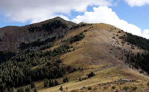
Sierra Blanca (also called the White Mountains) is a range of volcanic mountains in Lincoln and Otero counties of the south-central region of the U.S. state of New Mexico. This range has the highest mountain in Southern New Mexico and the seventh-highest peak in the state.[3] The range is about 40 miles (64 km) from north to south and 20 miles (32 km) wide.
It is dominated by Sierra Blanca Peak (White Peak), whose highest point is at 11,981 feet (3,652 m).[1] The peak is located on the Mescalero Apache Indian Reservation, 10 miles (16 km) west-northwest of Ruidoso and 30 miles (48 km) north-northeast of Alamogordo.
Geography
The majority of the Sierra Blanca range is within the Lincoln National Forest, and part of this is protected as the White Mountain Wilderness Area. Much of the southern half of the range, including the summit of Sierra Blanca Peak, is within the Mescalero Apache Indian Reservation. The peak is sacred to the Mescalero Apache Tribe, and requires a permit from them for access. To the south, across the valley of the Rio Tularosa, lie the Sacramento Mountains. To the north is Carrizozo Mountain, and to the northeast lie the Capitan Mountains. On the west side, the range rises high above the Tularosa Basin.
The range serves as the headwaters for the Rio Ruidoso, Rio Tularosa, and Rio Bonito, as well as numerous arroyos draining into the Tularosa Basin. These include Nogal Arroyo at the north end of the range.
The peak can be seen for many miles, particularly within the Tularosa Basin. It is visible from as far away as Sandia Crest near Albuquerque and is the highest point in southern New Mexico. It is one of the southernmost points at which alpine ecosystems occur in the United States. Rising more than 8,000 feet (2,400 m) above the adjacent Tularosa Basin, it has the highest prominence in the state.[4]
The eastern foothills of the Sierra Blanca range include the town of Ruidoso. The area has a number of popular hiking and camping destinations.
Sierra Blanca Peak is the towering backdrop and snow-maker for Ski Apache, the southernmost major ski resort in North America. The peak of Sierra Blanca is located on the Mescalero Apache Indian Reservation. Ski Apache is located mostly on land within the Lincoln National Forest and is operated as a concession under contract to the Forest Service by the Mescalero Apache Tribe's Inn of the Mountain Gods.[5]
Volcanology
Sierra Blanca is a massive complex of volcanic rocks, including pyroclastic materials, lava flows, and intrusions. An ancient and heavily eroded volcanic pile, it is the largest mid-Tertiary volcanic complex east of the Rio Grande, with an estimated volume of erupted products of 185 cubic miles (770 km3). Eruptions began about 38 million years ago, and extended over a twelve-million-year period. Most of the eruptions produced voluminous lava flows and breccias, with numerous intrusive dikes emplaced throughout the complex. The final activity produced the intrusions which form the present-day Sierra Blanca Peak. Following the volcanic period, the range's topography was modified by Pleistocene glaciation, block faulting, and erosion.
See also
References
- 1 2 3 "Sierra Blanca". NGS data sheet. U.S. National Geodetic Survey. Retrieved 2013-02-10.
- ↑ "Sierra Blanca Peak, New Mexico". Peakbagger.com. Retrieved 2013-02-10.
- ↑ "Sierra Blanca". Geographic Names Information System. United States Geological Survey. Retrieved 2013-02-10.
- ↑ "New Mexico Peaks with 2000 feet of Prominence". Peakbagger.com. Retrieved 2013-02-10.
- ↑ "Inn of the Mountain Gods Resort and Casino". Mescalero Apache tribe. Retrieved 2013-02-10.
- New Mexico Museum of Natural History and Science: Volcanoes of New Mexico and "Sierra Blanca Volcano". Retrieved 2007-03-26.
External links
- "Sierra Blanca Peak". Geographic Names Information System. United States Geological Survey.
- "Village of Ruidoso Tourism Office".
- "Ski Apache resort".
- "Inn of the Mountain Gods "Inn of the Mountain Gods Resort and Casino".
Santa Fe (capital) | |
| Topics |
|
| Society | |
| Regions | |
| Cities | |
| Counties | |