Borah Peak
| Borah Peak | |
|---|---|
 August 2009 | |
| Highest point | |
| Elevation | 12,662 ft (3,859 m) |
| Prominence | 5,982 ft (1,823 m) [1] |
| Listing | |
| Coordinates | 44°08′15″N 113°46′52″W / 44.1373891°N 113.78110123°WCoordinates: 44°08′15″N 113°46′52″W / 44.1373891°N 113.78110123°W [2] |
| Geography | |
 Borah Peak Idaho, U.S. | |
| Location | Custer County, Idaho, U.S. |
| Parent range | Lost River Range |
| Topo map | USGS Borah Peak |
| Climbing | |
| First ascent | 1912 by T.M. Bannon[3] |
| Easiest route | Scramble |
Borah Peak (also known as Mount Borah or Beauty Peak) is the highest mountain in the U.S. state of Idaho[4] and one of the most prominent peaks in the contiguous states.[5] It is located in the central section of the Lost River Range, within the Challis National Forest in eastern Custer County.
The mountain was nameless until it was discovered to be higher than Hyndman Peak, previously regarded as the state's highest point. In February 1934, the U.S. Geological Survey named it for William Borah,[6] the prominent senior U.S. Senator from Idaho, who had served for nearly 27 years at the time and was dean of the Senate. An outspoken isolationist, the "Lion of Idaho" ran for president two years later in 1936, but did not win the Republican nomination, and died in office in 1940.[7]
1983 earthquake

The 1983 Borah Peak earthquake occurred on October 28 at 8:06:09 local time in the Lost River Range at Borah Peak in central Idaho, United States, measuring 6.9 on the moment magnitude scale. Mount Borah rose about 1 foot (30 cm) and the Lost River Valley in that vicinity dropped about 8 feet (2.4 m).[8] The peak was scarred on the western side, and the mark is still visible. Two children in Challis were the only fatalities of the quake, struck by falling masonry while walking to elementary school.
Climbing
The normal route involves ascending 5,262 vertical feet (1,604 m) from the trailhead to the summit in just over 3.5 miles (5.6 km). This route on the southwest ridge, the most popular route, is a strenuous hike for the most part until one reaches a Class 4 arête just before the main summit crest. This point is known as Chickenout Ridge as many people will abort the attempt once they see the hazards up close. In the cooler seasons this crossing usually involves a traverse over snow, with steeply slanting slopes on either side. An ice axe, and the ability to use it, is recommended for this section when icy.
Borah Peak's north face is one of Idaho's only year-round snow climbs and provides a much greater challenge than the normal route. The face features a number of grade II class 5 routes on mixed terrain.
Three climbers have died on Borah Peak. Two climbers ascending the northwest ridge in 1977 were killed in an avalanche. Another climber in 1987 lost his life on a glissade during descent.[3]
 View from the summit
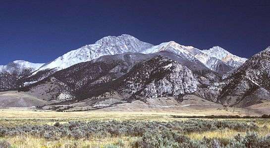 Borah Peak, looking east
See also
References
- ↑ "Borah Peak, Idaho". Peakbagger.com. Retrieved 2008-04-08.
- ↑ "Beauty Reset". NGS data sheet. U.S. National Geodetic Survey. Retrieved 2008-04-08.
- 1 2 "Borah Peak". IdahoSummits.com. Retrieved 2008-12-27.
- ↑ "Elevations and Distances in the United States". United States Geological Survey. April 29, 2005. Archived from the original on 2008-01-16. Retrieved 2009-03-28.
- ↑ "USA Lower 48 Top 100 Peaks by Prominence". Peakbagger.com. Retrieved 2012-05-04.
- ↑ "Named for solon: Idaho's highest mountain be called "Borah Peak"". Lewiston Morning Tribune. Idaho. Associated Press. February 12, 1934. p. 1.
- ↑ "Idaho's highest peak eternal memorial to Borah". Lewiston Morning Tribune. Idaho. January 26, 1940. p. 1.
- ↑ "Geologic Activity - Craters Of The Moon National Monument & Preserve (U.S. National Park Service)". www.nps.gov. Retrieved 2016-08-21.
External links
- Mount Borah Climbing Guide - photos of the normal route
- Borah Peak Trip Report
Faulting information: http://geology.gsapubs.org/content/12/11/664.abstract